|
Milton, New Zealand
Milton, formerly known as Tokomairiro or Tokomairaro, is a town of over 2,000 people, located on State Highway 1, 50 kilometres to the south of Dunedin in Otago, New Zealand. It lies on the floodplain of the Tokomairaro River, one branch of which loops past the north and south ends of the town. This river gives its name to many local features, notably the town's only secondary school, Tokomairiro High School. Founded as a milling town in the 1850s, there has long been dispute as to the naming of the settlement. The town's streets are named for prominent British poets, and it is possible that the town's original intended name of Milltown became shortened by association with the poet of the same name. It is equally possible, however, that the name Milton inspired the choice of poets' names for the streets. History Milton's early history was strongly affected by the discovery of gold by Gabriel Read at Gabriel's Gully close to the nearby township of Lawrence. As Milton stood ... [...More Info...] [...Related Items...] OR: [Wikipedia] [Google] [Baidu] |
Regions Of New Zealand
New Zealand is divided into sixteen regions () for local government purposes. Eleven are administered by regional councils (the top tier of local government), and five are administered by unitary authorities, which are territorial authorities (the second tier of local government) that also perform the functions of regional councils. The Chatham Islands Council is not a region but is similar to a unitary authority, authorised under its own legislation. Current regions History and statutory basis The regional councils are listed in Part 1 of Schedule 2 of the Local Government Act 2002, along with reference to the ''Gazette'' notices that established them in 1989. The Act requires regional councils to promote sustainable developmentthe social, economic, environmental and cultural well-being of their communities. The current regions and most of their councils came into being through a local government reform in 1989 that took place under the Local Government Act 1974. The r ... [...More Info...] [...Related Items...] OR: [Wikipedia] [Google] [Baidu] |
Gabriel's Gully
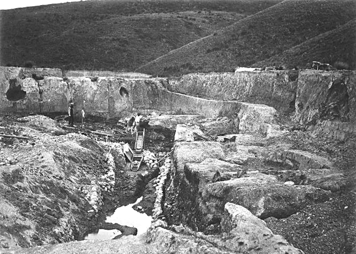
Gabriel's Gully is a locality in Otago, New Zealand, three kilometres from Lawrence township and close to the Tuapeka River. It was the site of New Zealand's first major gold rush. The discovery of gold at Gabriel's Gully by Gabriel Read on 25 May 1861 led to the Central Otago goldrush. While gold had been found in Otago before, this rush was beyond expectation, with the population of the gold field rising from almost nothing to around 11,500 within a year, twice that of Dunedin at the time.''Whykickamoocow - curious New Zealand place names'' - McCloy, Nicola, Random House New Zealand, 2006 It also stimulated overseas interest in the new colony. In May 1911, the jubilee of the discovery of gold in Gabriel's Gully was held in Lawrence, with around 2,000 people attending, including surviving miners. Gabriel's Gully today is now part of the Gabriels Gully Historic Reserve, and is managed by the Department of Conservation An environmental ministry is a national or subnati ... [...More Info...] [...Related Items...] OR: [Wikipedia] [Google] [Baidu] |
Green Island, New Zealand
Green Island is a suburb of Dunedin, New Zealand. Not an actual island, this former borough takes its name from the Green Island bush, uncleared native forest extending from the valley where the community is centred over the hills towards the coast. The name of the nearby offshore island — Green Island (Okaihe) — was used to identify the bush and, thus, also lent its name to the mainland suburb. Green Island suburb Under the 1989 local government reforms, the city of Dunedin and its surrounding region was grouped into a territorial authority called Dunedin City. Under this system, Green Island is officially an outer suburb within this territorial authority. Green Island is on State Highway 1, about west-southwest of the Octagon, Dunedin's city centre. Along with neighbouring Abbotsford, it is the westernmost suburb within Dunedin City's main urban area. Green Island's main economy is based on light and small scale heavy industry. Prior to 1950 Green Island, and neighbou ... [...More Info...] [...Related Items...] OR: [Wikipedia] [Google] [Baidu] |
Main South Line
The Main South Line, sometimes referred to as part of the South Island Main Trunk Railway, is a railway line that runs north and south from Lyttelton in New Zealand through Christchurch and along the east coast of the South Island to Invercargill via Dunedin. It is one of the most important railway lines in New Zealand and was one of the first to be built, with construction commencing in the 1860s. At Christchurch, it connects with the Main North Line to Picton, the other part of the South Island Main Trunk. Construction Construction of the Main South Line falls into two main sections: from Christchurch through southern Canterbury to Otago's major city of Dunedin; and linking the southern centres of Dunedin and Invercargill, improving communication in southern Otago and large parts of Southland. Construction of the first section of the line began in 1865 and the whole line was completed on 22 January 1879. Christchurch-Dunedin section The Canterbury provincial govern ... [...More Info...] [...Related Items...] OR: [Wikipedia] [Google] [Baidu] |
Railway
Rail transport (also known as train transport) is a means of transport that transfers passengers and goods on wheeled vehicles running on rails, which are incorporated in Track (rail transport), tracks. In contrast to road transport, where the vehicles run on a prepared flat surface, rail vehicles (rolling stock) are directionally guided by the tracks on which they run. Tracks usually consist of steel rails, installed on Railroad tie, sleepers (ties) set in track ballast, ballast, on which the rolling stock, usually fitted with metal wheels, moves. Other variations are also possible, such as "slab track", in which the rails are fastened to a concrete foundation resting on a prepared subsurface. Rolling stock in a rail transport system generally encounters lower friction, frictional resistance than rubber-tyred road vehicles, so passenger and freight cars (carriages and wagons) can be coupled into longer trains. The rail transport operations, operation is carried out by a ... [...More Info...] [...Related Items...] OR: [Wikipedia] [Google] [Baidu] |
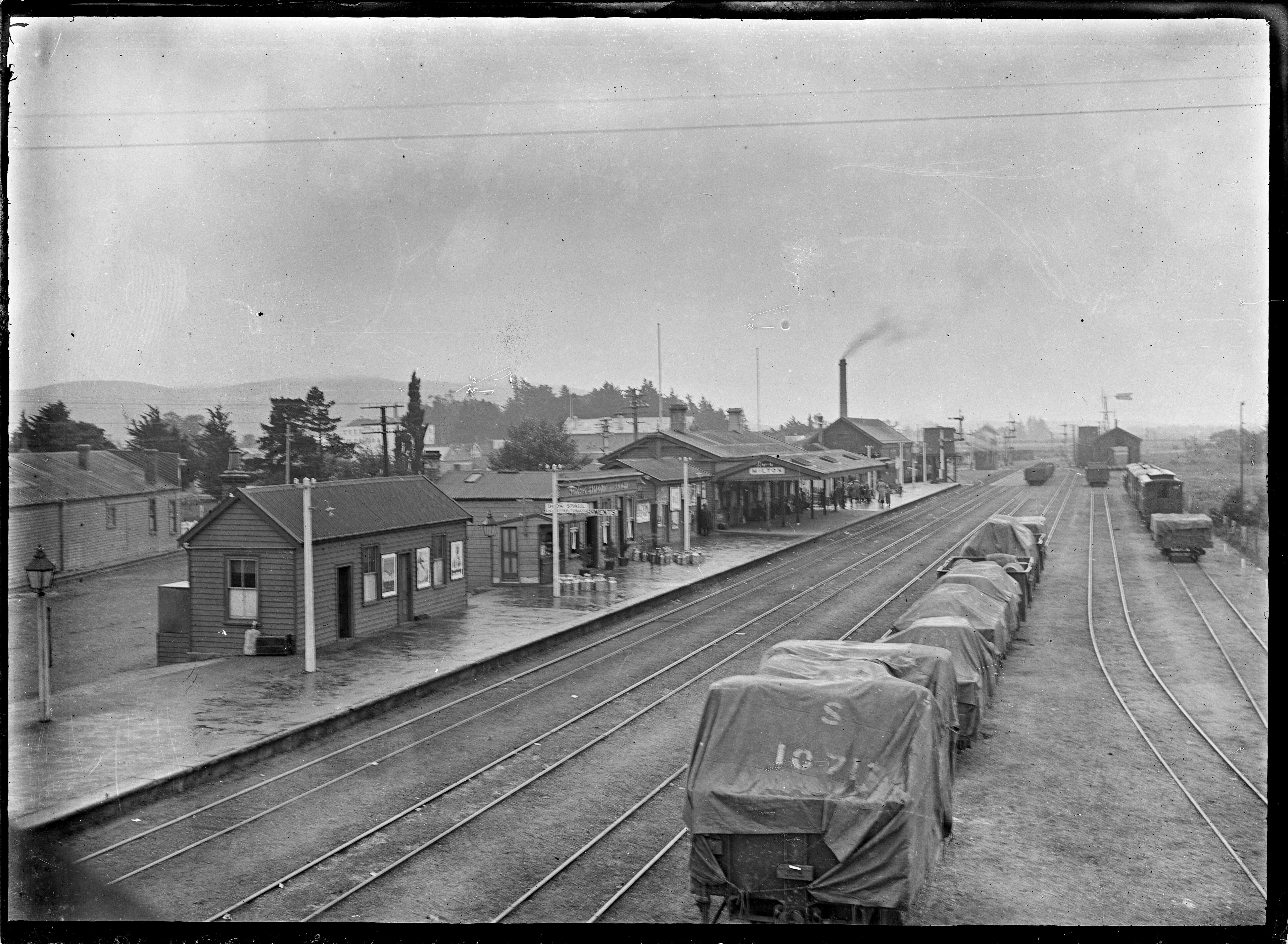
Milton Railway Station ATLIB 313102
Milton may refer to: Names * Milton (surname), a surname (and list of people with that surname) ** John Milton (1608–1674), English poet * Milton (given name) ** Milton Friedman (1912–2006), Nobel laureate in Economics, author of '' Free to Choose'' Places Australia * Milton, New South Wales * Milton, Queensland, a suburb of Brisbane ** Milton Courts, a tennis centre ** Milton House, Milton, a heritage-listed house ** Milton railway station, Brisbane ** Milton Reach, a reach of the Brisbane River ** Milton Road, an arterial road in Brisbane Canada * Milton, Newfoundland and Labrador * Milton, Nova Scotia in the Region of Queens Municipality * Milton, Ontario ** Milton line, a commuter train line ** Milton GO Station * Milton (electoral district), Ontario ** Milton (provincial electoral district), Ontario * Beaverton, Ontario a community in Durham Region and renamed as Beaverton in 1835 * Rural Municipality of Milton No. 292, Saskatchewan New Zealand * Milton, ... [...More Info...] [...Related Items...] OR: [Wikipedia] [Google] [Baidu] |
Balclutha, New Zealand
Balclutha ( mi, Iwikatea) is a town in South Otago, lying towards the end of the Clutha River, on the east coast of the South Island of New Zealand. It is about halfway between Dunedin and Gore on the Main South Line railway, State Highway 1 and the Southern Scenic Route. Balclutha has a population of (as of ), and is the largest town in South Otago. The Clutha District Council is based in Balclutha. The major service centre for the fertile farming region around the lower reaches of the Clutha River, it is also the nearest large town to the Catlins, a scenic region of native forest, wildlife, and rugged coastline. History Known locally as "Clutha", Balclutha's name – and that of the river on which it stands – reflects the Scottish origin of the town's settlement. The name comes from Scottish Gaelic and would be spelt Baile Chluaidh in that language; this translates into English as "Town on the Clyde". James McNeil from Bonn Hill, Dumbartonshire, Scotland, who is ... [...More Info...] [...Related Items...] OR: [Wikipedia] [Google] [Baidu] |
Telephone
A telephone is a telecommunications device that permits two or more users to conduct a conversation when they are too far apart to be easily heard directly. A telephone converts sound, typically and most efficiently the human voice, into electronic signals that are transmitted via cables and other communication channels to another telephone which reproduces the sound to the receiving user. The term is derived from el, τῆλε (''tēle'', ''far'') and φωνή (''phōnē'', ''voice''), together meaning ''distant voice''. A common short form of the term is ''phone'', which came into use early in the telephone's history. In 1876, Alexander Graham Bell was the first to be granted a United States patent for a device that produced clearly intelligible replication of the human voice at a second device. This instrument was further developed by many others, and became rapidly indispensable in business, government, and in households. The essential elements of a telephone are ... [...More Info...] [...Related Items...] OR: [Wikipedia] [Google] [Baidu] |
Terminating Vista
In urban design, a terminating vista is a building or monument that stands at the end or in the middle of a road, so that when one is looking up the street the view ends with the site. Function Terminating vistas are considered an important method of adding aesthetic appeal to a city, and to emphasize important structures or monuments. Common terminating vistas include government buildings, war memorials, courthouses and other important structures. Standing at the end of a street adds grandeur to a structure, and legislature and palaces are thus often placed in such a locale. Also, especially on east-west streets, terminating vistas provide sunshade for the pedestrian. The important disadvantage of terminating vistas is that they make traffic more complicated and prevent a simple grid system of city blocks. To accommodate them, large traffic circles or other techniques have to be employed to get traffic around the monument. Cities on a grid system such as New York City thus ... [...More Info...] [...Related Items...] OR: [Wikipedia] [Google] [Baidu] |
Robert Lawson (architect)
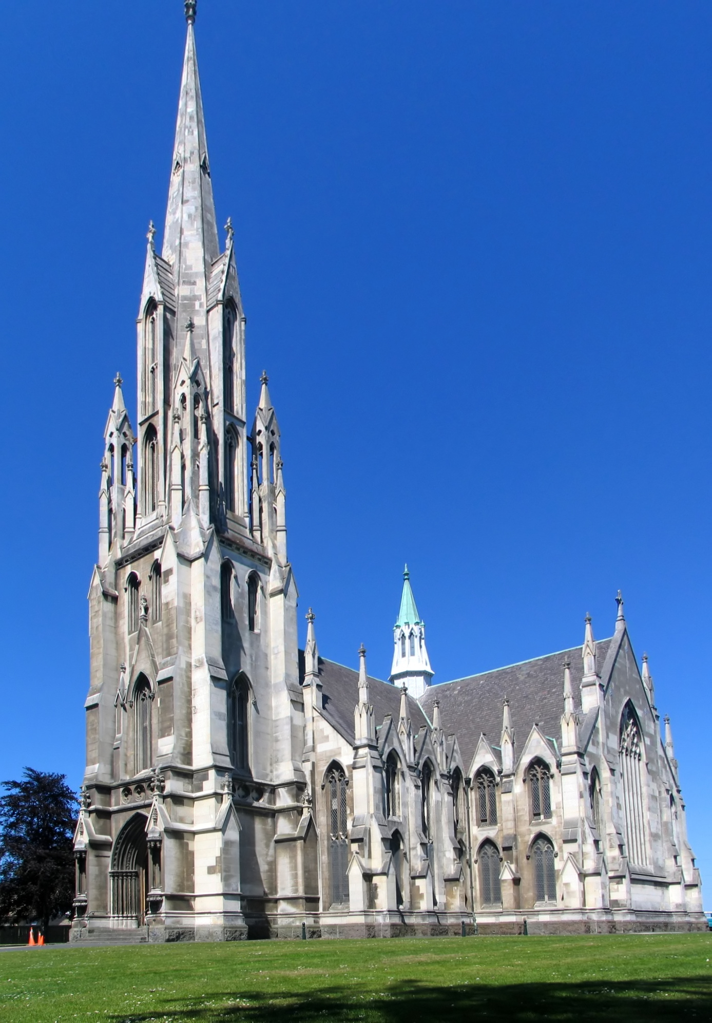
Robert Arthur Lawson (1 January 1833 – 3 December 1902) was one of New Zealand's pre-eminent 19th century architects. It has been said he did more than any other designer to shape the face of the Victorian era architecture of the city of Dunedin. He is the architect of over forty churches, including Dunedin's First Church for which he is best remembered, but also other buildings, such as Larnach Castle, a country house, with which he is also associated. Born at Newburgh, in Fife, Scotland, he emigrated in 1854 to Australia and then in 1862 to New Zealand. He died aged 69 in Canterbury, New Zealand. Lawson is acclaimed for his work in both the Gothic revival and classical styles of architecture. He was prolific, and while isolated buildings remain in Scotland and Australia, it is in the Dunedin area that most surviving examples can now be found. Today he is held in high esteem in his adopted country. However, at the time of his death his reputation was at a low ... [...More Info...] [...Related Items...] OR: [Wikipedia] [Google] [Baidu] |
Presbyterian Church Of Aotearoa New Zealand
The Presbyterian Church of Aotearoa New Zealand (PCANZ) is a major Christian denomination in New Zealand. A part of the Reformed tradition, it is the largest Presbyterian denomination in New Zealand, and known for its relatively progressive stance on doctrine and social issues in comparison with smaller Presbyterian churches in the country. Presbyterianism was introduced to New Zealand by early 19th century settlers, particularly from Scotland and Ireland. It was historically most prevalent in the Otago region. The PCANZ was formed in 1901 with the amalgamation of southern and northern Presbyterian churches. It claims around 29,000 members. History The Presbyterian Church of New Zealand formed in October 1901 with the amalgamation of churches in the Synod of Otago and Southland (which had a largely Free Church heritage) with those north of the Waitaki River. Unlike other major Christian churches, the Presbyterians did not send missionaries to New Zealand. Presbyterians had by ... [...More Info...] [...Related Items...] OR: [Wikipedia] [Google] [Baidu] |
Gothic Architecture
Gothic architecture (or pointed architecture) is an architectural style that was prevalent in Europe from the late 12th to the 16th century, during the High and Late Middle Ages, surviving into the 17th and 18th centuries in some areas. It evolved from Romanesque architecture and was succeeded by Renaissance architecture. It originated in the Île-de-France and Picardy regions of northern France. The style at the time was sometimes known as ''opus Francigenum'' (lit. French work); the term ''Gothic'' was first applied contemptuously during the later Renaissance, by those ambitious to revive the architecture of classical antiquity. The defining design element of Gothic architecture is the pointed or ogival arch. The use of the pointed arch in turn led to the development of the pointed rib vault and flying buttresses, combined with elaborate tracery and stained glass windows. At the Abbey of Saint-Denis, near Paris, the choir was reconstructed between 1140 and 114 ... [...More Info...] [...Related Items...] OR: [Wikipedia] [Google] [Baidu] |


.jpg)