|
Mianzimu
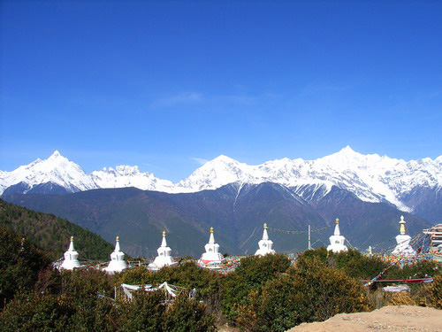
Mianzimu (缅茨姆) is a summit in the Meili Xue Shan of Yunnan province, China. At , it is the fourth highest peak in the range (after Kawagebo Kawa Garbo or Khawa Karpo (; also transcribed as Kawadgarbo, Khawakarpo, Moirig Kawagarbo, Kawa Karpo or Kha-Kar-Po), as it is known by local residents and pilgrims, or Kawagebo Peak (), is the highest mountain in the Chinese province of Yunnan. ..., Cogar Laka and Nairi Denka), and is located at the southern end of the range. It is regarded as one of the world's most beautiful mountains. References {{coord missing, Yunnan Mountains of Yunnan Geography of Dêqên Tibetan Autonomous Prefecture ... [...More Info...] [...Related Items...] OR: [Wikipedia] [Google] [Baidu] |
Meili Xue Shan
Meili Xue Shan (Chinese:梅里雪山, translation: "Mainri snowy range") or Mainri Snow Mountains (Tibetan: སྨན་རི།) is a mountain range in the Chinese province of Yunnan. It lies close to the northwestern boundary of the province and is bounded by the Salween River on the west and the Mekong on the east. The Meili are subrange of the larger Nu Mountains, themselves a constituent range of the Hengduan group. The crest of the range rises to over 6,000 metres (20,000 ft) above sea level, making for impressive prominence over the river valleys to the east and west, which are between 1,500 metres (4,900 ft) and 1,900 metres (6,200 ft) in elevation. The highest peak is Kawagarbo, which rises to 6,740 metres (22,110 ft). Kawagarbo is considered sacred for Tibetan Buddhists. Other significant peaks include Mianzimu, Cogar Laka and Jiariren-an. Because of restrictions and dangerous conditions, none of the major peaks in the range have ever been summited. Name In Tibet, ... [...More Info...] [...Related Items...] OR: [Wikipedia] [Google] [Baidu] |
Kawagebo
Kawa Garbo or Khawa Karpo (; also transcribed as Kawadgarbo, Khawakarpo, Moirig Kawagarbo, Kawa Karpo or Kha-Kar-Po), as it is known by local residents and pilgrims, or Kawagebo Peak (), is the highest mountain in the Chinese province of Yunnan. It is located on the border between Dêqên County, Yunnan, and the counties of Zogang and Zayü of the Tibet Autonomous Region. It rises about west of Shengping (升平镇), the seat of Dêqên County, which lies on China National Highway 214. What is now Dêqên County has been part of Yunnan since the 1720s, when the current border with Tibet was established by the early Qing Dynasty. Kawagarbo is one of the most sacred peaks in the Tibetan world Keith Dowman. 1997. The Sacred Life of Tibet. San Francisco, California, USA: Thorsons. and is often referred to as Nyainqênkawagarbo to show its sacredness and avoid ambiguousness with the other Kawagarbo in the Anung-Derung-speaking Gongshan County. Geography Kawagarbo is the high p ... [...More Info...] [...Related Items...] OR: [Wikipedia] [Google] [Baidu] |
Yunnan
Yunnan , () is a landlocked Provinces of China, province in Southwest China, the southwest of the People's Republic of China. The province spans approximately and has a population of 48.3 million (as of 2018). The capital of the province is Kunming. The province borders the Chinese provinces of Guizhou, Sichuan, autonomous regions of Guangxi, and Tibet Autonomous Region, Tibet as well as Southeast Asian countries: Vietnam, Laos, and Myanmar. Yunnan is China's fourth least developed province based on disposable income per capita in 2014. Yunnan is situated in a mountainous area, with high elevations in the northwest and low elevations in the southeast. Most of the population lives in the eastern part of the province. In the west, the altitude can vary from the mountain peaks to river valleys by as much as . Yunnan is rich in natural resources and has the largest diversity of plant life in China. Of the approximately 30,000 species of Vascular plant, higher plants in China, Yu ... [...More Info...] [...Related Items...] OR: [Wikipedia] [Google] [Baidu] |
China
China, officially the People's Republic of China (PRC), is a country in East Asia. It is the world's most populous country, with a population exceeding 1.4 billion, slightly ahead of India. China spans the equivalent of five time zones and borders fourteen countries by land, the most of any country in the world, tied with Russia. Covering an area of approximately , it is the world's third largest country by total land area. The country consists of 22 provinces, five autonomous regions, four municipalities, and two Special Administrative Regions (Hong Kong and Macau). The national capital is Beijing, and the most populous city and financial center is Shanghai. Modern Chinese trace their origins to a cradle of civilization in the fertile basin of the Yellow River in the North China Plain. The semi-legendary Xia dynasty in the 21st century BCE and the well-attested Shang and Zhou dynasties developed a bureaucratic political system to serve hereditary monarchies, or dyna ... [...More Info...] [...Related Items...] OR: [Wikipedia] [Google] [Baidu] |
Cogar Laka
''Cogar'' (; "Whisper") is an Irish television documentary series, shown on the Irish language channel TG4. It focuses on people who have been "ignored" or are at the margins of society. ''Cogar'' was first broadcast in 2000, the first episode looking at Dublin's bicycle couriers. Episodes Notable episodes *2002: ''Paddy Fitz, Fear an Hata'' ("Paddy Fitz, the Man with the Hat"): on the storyteller Paddy Fitzpatrick *2006: ''Ar Thóir Hy Brasil'' ("In Search of Hy-Brazil"), a documentary on the mythical island *2008: an episode on Irish Community Care Manchester *2011: ''Buabhaill ar na Bánta'' ("Where the Buffalo Roam"), about a water buffalo farmer in County Cork *2011: an episode on Cork's Hadji Bey sweetshop *2011: ''Éamonn Ó Cathain – An Fear Iarainn'' (" Eamonn Keane, the Ironman"), covering a County Mayo weightlifter *2014: ''Bliain an tSneachta Mhóir'' ("Year of the Big Snow"), on the 1946–47 heavy snowfall *2015: Episode on the four Irish American baseball-pla ... [...More Info...] [...Related Items...] OR: [Wikipedia] [Google] [Baidu] |
Nairi Denka
Nairi ( classical hy, Նայիրի, ''Nayiri'', reformed: Նաիրի, ''Nairi''; , also ''Na-'i-ru'') was the Akkadian name for a region inhabited by a particular group (possibly a confederation or league) of tribal principalities in the Armenian Highlands, approximately spanning the area between modern Diyabakır and Lake Van and the region west of Lake Urmia. Nairi has sometimes been equated with Nihriya, known from Mesopotamian, Hittite, and Urartian sources. However, its co-occurrence with Nihriya within a single text may argue against this. Prior to the Bronze Age collapse, the Nairi tribes were considered a force strong enough to contend with both Assyria and Hatti. If Nairi and Nihriya are to be identified, then the region was the site of the Battle of Nihriya (c. 1230 BCE), the culminating point of the hostilities between Hittites and Assyrians for control over the remnants of the former kingdom of Mitanni. The first kings of Urartu referred to their kingdom as ''Na ... [...More Info...] [...Related Items...] OR: [Wikipedia] [Google] [Baidu] |
Mountains Of Yunnan
A mountain is an elevated portion of the Earth's crust, generally with steep sides that show significant exposed bedrock. Although definitions vary, a mountain may differ from a plateau in having a limited summit area, and is usually higher than a hill, typically rising at least 300 metres (1,000 feet) above the surrounding land. A few mountains are isolated summits, but most occur in mountain ranges. Mountains are formed through tectonic forces, erosion, or volcanism, which act on time scales of up to tens of millions of years. Once mountain building ceases, mountains are slowly leveled through the action of weathering, through slumping and other forms of mass wasting, as well as through erosion by rivers and glaciers. High elevations on mountains produce colder climates than at sea level at similar latitude. These colder climates strongly affect the ecosystems of mountains: different elevations have different plants and animals. Because of the less hospitable terrain and ... [...More Info...] [...Related Items...] OR: [Wikipedia] [Google] [Baidu] |


