|
Menagissey
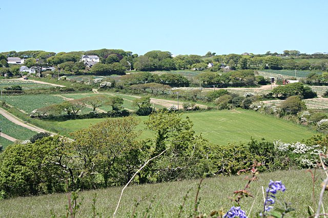
Menagissey is a Hamlet (place), hamlet in Cornwall, England, United Kingdom. It is half-a-mile south of Mount Hawke about three miles (5 km) north-northeast of Redruth in the civil parish of St Agnes, Cornwall, St Agnes. It is included in the Mount Hawke and Portreath (electoral division), Mount Hawke and Portreath division on Cornwall Council. It consists of cottages, bungalows and several farms above a steep valley. Into Cornwall website; Menagissey; retrieved April 2010 References Hamlets in Cornwall {{Cornwall-geo-stub ...[...More Info...] [...Related Items...] OR: [Wikipedia] [Google] [Baidu] |
St Agnes, Cornwall
St Agnes ( kw, Breanek) is a civil parish and a large village on the north coast of Cornwall, UK. The village is about five miles (8 km) north of Redruth and ten miles (16 km) southwest of Newquay. ''and'' An electoral ward exists stretching as far south as Blackwater. The population at the 2011 census was 7,565. The village of St Agnes, a popular coastal tourist spot, lies on a main road between Redruth and Perranporth. It was a prehistoric and modern centre for mining of copper, tin and arsenic until the 1920s. Local industry has also included farming, fishing and quarrying, and more recently tourism. The St Agnes district has a heritage of industrial archaeology and much of the landscape is of considerable geological interest. There are also stone-age remains in the parish. The manor of Tywarnhaile was one of the 17 Antiqua maneria of the Duchy of Cornwall. Geography St Agnes, on Cornwall's north coast along the Atlantic Ocean, is in the Pydar hundred ... [...More Info...] [...Related Items...] OR: [Wikipedia] [Google] [Baidu] |
Mount Hawke
Mount Hawke is a village in Cornwall, United Kingdom. It is situated approximately west-northwest of Truro, north-northeast of Redruth, and south of St Agnes. The village is in a former mining area in the administrative civil parish of St Agnes. It has a school, Mount Hawke Community Primary School, a post office and various shops. The settlements bordering Mount Hawke are Banns (northwest) and Menagissey (south); Porthtowan is further away westward. The village is represented on Cornwall Council by the electoral division of Mount Hawke and Portreath. The population as of the 2011 census was 4,401. Churches Mount Hawke ecclesiastical parish was created in 1847 from part of the parish of Perranzabuloe and a smaller part of the parish of Illogan. Before this date, Mount Hawke was enumerated under St Agnes. The parish has been in the Hundred of Powder and the Truro Registration District since its creation. It is in the rural deanery of Powder and the archdeaconry o ... [...More Info...] [...Related Items...] OR: [Wikipedia] [Google] [Baidu] |
Mount Hawke And Portreath (electoral Division)
Mount Hawke and Portreath ( Cornish: ) was an electoral division of Cornwall in the United Kingdom which returned one member to sit on Cornwall Council between 2009 and 2021. It was abolished at the 2021 local elections, and was split between the divisions of St Agnes, Illogan and Portreath, Perranporth, and Redruth North. Councillors Extent The division covered the villages of Portreath, Porthtowan and Mount Hawke as well as the hamlets of Menagissey, Cambrose and Banns. Parts of Mawla and Wheal Rose were also included, with both being split between the divisions of Mount Hawke & Portreath and Redruth North. The division was minorly affected by boundary changes at the 2013 election. From 2009 to 2013, the division covered 2134.7 hectares; from 2013 to 2021, it covered 2135.2 hectares. Election results 2017 election 2013 election 2009 election References Electoral divisions of Cornwall Council {{UKward-geo-stu ... [...More Info...] [...Related Items...] OR: [Wikipedia] [Google] [Baidu] |
The Fields Of Menagissey - Geograph
''The'' () is a grammatical article in English, denoting persons or things that are already or about to be mentioned, under discussion, implied or otherwise presumed familiar to listeners, readers, or speakers. It is the definite article in English. ''The'' is the most frequently used word in the English language; studies and analyses of texts have found it to account for seven percent of all printed English-language words. It is derived from gendered articles in Old English which combined in Middle English and now has a single form used with nouns of any gender. The word can be used with both singular and plural nouns, and with a noun that starts with any letter. This is different from many other languages, which have different forms of the definite article for different genders or numbers. Pronunciation In most dialects, "the" is pronounced as (with the voiced dental fricative followed by a schwa) when followed by a consonant sound, and as (homophone of the archai ... [...More Info...] [...Related Items...] OR: [Wikipedia] [Google] [Baidu] |
Hamlet (place)
A hamlet is a human settlement that is smaller than a town or village. Its size relative to a Parish (administrative division), parish can depend on the administration and region. A hamlet may be considered to be a smaller settlement or subdivision or satellite entity to a larger settlement. The word and concept of a hamlet has roots in the Anglo-Norman settlement of England, where the old French ' came to apply to small human settlements. Etymology The word comes from Anglo-Norman language, Anglo-Norman ', corresponding to Old French ', the diminutive of Old French ' meaning a little village. This, in turn, is a diminutive of Old French ', possibly borrowed from (West Germanic languages, West Germanic) Franconian languages. Compare with modern French ', Dutch language, Dutch ', Frisian languages, Frisian ', German ', Old English ' and Modern English ''home''. By country Afghanistan In Afghanistan, the counterpart of the hamlet is the Qila, qala (Dari language, Dari: ... [...More Info...] [...Related Items...] OR: [Wikipedia] [Google] [Baidu] |
Cornwall
Cornwall (; kw, Kernow ) is a historic county and ceremonial county in South West England. It is recognised as one of the Celtic nations, and is the homeland of the Cornish people. Cornwall is bordered to the north and west by the Atlantic Ocean, to the south by the English Channel, and to the east by the county of Devon, with the River Tamar forming the border between them. Cornwall forms the westernmost part of the South West Peninsula of the island of Great Britain. The southwesternmost point is Land's End and the southernmost Lizard Point. Cornwall has a population of and an area of . The county has been administered since 2009 by the unitary authority, Cornwall Council. The ceremonial county of Cornwall also includes the Isles of Scilly, which are administered separately. The administrative centre of Cornwall is Truro, its only city. Cornwall was formerly a Brythonic kingdom and subsequently a royal duchy. It is the cultural and ethnic origin of the Cornish dias ... [...More Info...] [...Related Items...] OR: [Wikipedia] [Google] [Baidu] |
Redruth
Redruth ( , kw, Resrudh) is a town and civil parishes in Cornwall, civil parish in Cornwall, England. The population of Redruth was 14,018 at the 2011 census. In the same year the population of the Camborne-Redruth urban area, which also includes Carn Brea, Redruth, Carn Brea, Illogan and several satellite villages, stood at 55,400 making it the largest conurbation in Cornwall. Redruth lies approximately at the junction of the Great Britain road numbering scheme, A393 and A3047 roads, on the route of the old London to Land's End trunk road (now the A30 road, A30), and is approximately west of Truro, east of St Ives, Cornwall, St Ives, north east of Penzance, Cornwall, Penzance and north west of Falmouth, Cornwall, Falmouth. Camborne and Redruth together form the largest urban area in Cornwall and before local government reorganisation were an Urban district (Great Britain and Ireland), urban district. Toponymy The name Redruth derives from its older Cornish name, ''Rhy ... [...More Info...] [...Related Items...] OR: [Wikipedia] [Google] [Baidu] |
Civil Parish
In England, a civil parish is a type of administrative parish used for local government. It is a territorial designation which is the lowest tier of local government below districts and counties, or their combined form, the unitary authority. Civil parishes can trace their origin to the ancient system of ecclesiastical parishes, which historically played a role in both secular and religious administration. Civil and religious parishes were formally differentiated in the 19th century and are now entirely separate. Civil parishes in their modern form came into being through the Local Government Act 1894, which established elected parish councils to take on the secular functions of the parish vestry. A civil parish can range in size from a sparsely populated rural area with fewer than a hundred inhabitants, to a large town with a population in the tens of thousands. This scope is similar to that of municipalities in Continental Europe, such as the communes of France. However, ... [...More Info...] [...Related Items...] OR: [Wikipedia] [Google] [Baidu] |
Cornwall Council
Cornwall Council ( kw, Konsel Kernow) is the unitary authority for Cornwall in the United Kingdom, not including the Isles of Scilly, which has its own unitary council. The council, and its predecessor Cornwall County Council, has a tradition of large groups of independent councillors, having been controlled by independents in the 1970s and 1980s. Since the 2021 elections, it has been under the control of the Conservative Party. Cornwall Council provides a wide range of services to the approximately half a million people who live in Cornwall. In 2014 it had an annual budget of more than £1 billion and was the biggest employer in Cornwall with a staff of 12,429 salaried workers. It is responsible for services including: schools, social services, rubbish collection, roads, planning and more. History Establishment of the unitary authority On 5 December 2007, the Government confirmed that Cornwall was one of five councils that would move to unitary status. This was enacted by st ... [...More Info...] [...Related Items...] OR: [Wikipedia] [Google] [Baidu] |


.png)

