|
Mandji
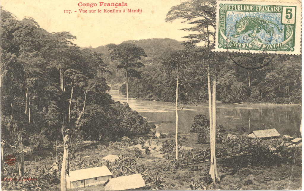
Lastoursville or Mandji is a city in east-central Gabon, lying on the Ogooué River, the Trans-Gabon Railway and the N3 road. It was founded as a slave depot named ''Mandji'', renamed ''Maadiville'' in 1883 and finally took its current name for François Rigail de Lastours in 1886. It grew around palm oil production and as an administrative centre, and soon became a major missionary centre. The town is also known for its caves. The town lies at an elevation of 206 m. Caves Occupying a 90-sq-km site, there are more than 40 caves identified, located in dense primary rainforest close to town. Traces of human activity dates back 7000 years, when the caves were used in rituals. World Heritage Status The caves were added to the UNESCO World Heritage A World Heritage Site is a landmark or area with legal protection by an international convention administered by the United Nations Educational, Scientific and Cultural Organization (UNESCO). World Heritage Sites are de ... [...More Info...] [...Related Items...] OR: [Wikipedia] [Google] [Baidu] |
Departments Of Gabon
The provinces of Gabon are divided into forty-nine departments. The departments are listed below, by province (capitals in parentheses): Estuaire Province *Komo Department (Kango) *Komo-Mondah Department (Ntoum) *Noya Department (Cocobeach) * Komo-Océan Department ( Ndzomoe) * Libreville (department & capital city) The Department of Cap Estérias ( Cap Estérias) was deleted in 2013. Haut-Ogooué Province *Djoue Department ( Onga) * Djououri-Aguilli Department (Bongoville) * Lekoni-Lekori Department ( Akiéni) * Lekoko Department ( Bakoumba) * Leboumbi-Leyou Department ( Moanda) * Mpassa Department (Franceville) * Plateaux Department ( Leconi) * Sebe-Brikolo Department ( Okondja) * Ogooué-Létili Department ( Boumango) * Lékabi-Léwolo Department ( Ngouoni) * Bayi-Brikolo Department ( Aboumi) Moyen-Ogooué Province * Abanga-Bigne Department ( Ndjole) * Ogooué et des Lacs Department (Lambaréné) Ngounié Province * Boumi-Louetsi Department ( Mbigou) * D ... [...More Info...] [...Related Items...] OR: [Wikipedia] [Google] [Baidu] |
Provinces Of Gabon
Gabon (; ; snq, Ngabu), officially the Gabonese Republic (french: République gabonaise), is a country on the west coast of Central Africa. Located on the equator, it is bordered by Equatorial Guinea to the northwest, Cameroon to the north, the Republic of the Congo on the east and south, and the Gulf of Guinea to the west. It has an area of nearly and its population is estimated at million people. There are coastal plains, mountains (the Cristal Mountains and the Chaillu Massif in the centre), and a savanna in the east. Since its independence from France in 1960, the sovereign state of Gabon has had three presidents. In the 1990s, it introduced a multi-party system and a democratic constitution that aimed for a more transparent electoral process and reformed some governmental institutions. With petroleum and foreign private investment, it has the fourth highest HDI in the region (after Mauritius, Seychelles and South Africa) and the fifth highest GDP per capita (PPP) in ... [...More Info...] [...Related Items...] OR: [Wikipedia] [Google] [Baidu] |
World Heritage
A World Heritage Site is a landmark or area with legal protection by an international convention administered by the United Nations Educational, Scientific and Cultural Organization (UNESCO). World Heritage Sites are designated by UNESCO for having cultural, historical, scientific or other form of significance. The sites are judged to contain "cultural and natural heritage around the world considered to be of outstanding value to humanity". To be selected, a World Heritage Site must be a somehow unique landmark which is geographically and historically identifiable and has special cultural or physical significance. For example, World Heritage Sites might be ancient ruins or historical structures, buildings, cities, deserts, forests, islands, lakes, monuments, mountains, or wilderness areas. A World Heritage Site may signify a remarkable accomplishment of humanity, and serve as evidence of our intellectual history on the planet, or it might be a place of great natural beauty. As ... [...More Info...] [...Related Items...] OR: [Wikipedia] [Google] [Baidu] |
UNESCO
The United Nations Educational, Scientific and Cultural Organization is a specialized agency of the United Nations (UN) aimed at promoting world peace and security through international cooperation in education, arts, sciences and culture. It has 193 member states and 12 associate members, as well as partners in the non-governmental, intergovernmental and private sector. Headquartered at the World Heritage Centre in Paris, France, UNESCO has 53 regional field offices and 199 national commissions that facilitate its global mandate. UNESCO was founded in 1945 as the successor to the League of Nations's International Committee on Intellectual Cooperation.English summary). Its constitution establishes the agency's goals, governing structure, and operating framework. UNESCO's founding mission, which was shaped by the Second World War, is to advance peace, sustainable development and human rights by facilitating collaboration and dialogue among nations. It pursues this objective t ... [...More Info...] [...Related Items...] OR: [Wikipedia] [Google] [Baidu] |
Cave
A cave or cavern is a natural void in the ground, specifically a space large enough for a human to enter. Caves often form by the weathering of rock and often extend deep underground. The word ''cave'' can refer to smaller openings such as sea caves, rock shelters, and grottos, that extend a relatively short distance into the rock and they are called ''exogene'' caves. Caves which extend further underground than the opening is wide are called ''endogene'' caves. Speleology is the science of exploration and study of all aspects of caves and the cave environment. Visiting or exploring caves for recreation may be called ''caving'', ''potholing'', or ''spelunking''. Formation types The formation and development of caves is known as ''speleogenesis''; it can occur over the course of millions of years. Caves can range widely in size, and are formed by various geological processes. These may involve a combination of chemical processes, erosion by water, tectonic forces, microorgani ... [...More Info...] [...Related Items...] OR: [Wikipedia] [Google] [Baidu] |
Missionary
A missionary is a member of a Religious denomination, religious group which is sent into an area in order to promote its faith or provide services to people, such as education, literacy, social justice, health care, and economic development.Thomas Hale 'On Being a Missionary' 2003, William Carey Library Pub, . In the Bible translations into Latin, Latin translation of the Bible, Jesus, Jesus Christ says the word when he sends the disciples into areas and commands them to preach the gospel in his name. The term is most commonly used in reference to Christian missions, but it can also be used in reference to any creed or ideology. The word ''mission'' originated in 1598 when Jesuits, the members of the Society of Jesus sent members abroad, derived from the Latin (nominative case, nom. ), meaning 'act of sending' or , meaning 'to send'. By religion Buddhist missions The first Buddhist missionaries were called "Dharma Bhanaks", and some see a missionary charge in the symbolis ... [...More Info...] [...Related Items...] OR: [Wikipedia] [Google] [Baidu] |
Administrative Centre
An administrative center is a seat of regional administration or local government, or a county town, or the place where the central administration of a commune is located. In countries with French as administrative language (such as Belgium, Luxembourg, Switzerland and many African countries), a (, plural form , literally 'chief place' or 'main place'), is a town or city that is important from an administrative perspective. Algeria The capital of an Algerian province is called a chef-lieu. The capital of a district, the next largest division, is also called a chef-lieu, whilst the capital of the lowest division, the municipalities, is called agglomération de chef-lieu (chef-lieu agglomeration) and is abbreviated as A.C.L. Belgium The chef-lieu in Belgium is the administrative centre of each of the ten provinces of Belgium. Three of these cities also give their name to their province ( Antwerp, Liège and Namur). France The chef-lieu of a département is known as the ''pr ... [...More Info...] [...Related Items...] OR: [Wikipedia] [Google] [Baidu] |
Palm Oil
Palm oil is an edible vegetable oil derived from the mesocarp (reddish pulp) of the fruit of the oil palms. The oil is used in food manufacturing, in beauty products, and as biofuel. Palm oil accounted for about 33% of global oils produced from oil crops in 2014. Palm oils are easier to stabilize and maintain quality of flavor and consistency in processed foods, so are frequently favored by food manufacturers. On average globally, humans consumed 7.7 kg (17 lb) of palm oil per person in 2015. Demand has also increased for other uses, such as cosmetics and biofuels, creating more demand on the supply encouraging the growth of palm oil plantations in tropical countries. The use of palm oil has attracted the concern of environmental groups due to deforestation in the tropics where palms are grown, and has been cited as a factor in social problems due to allegations of human rights violations among growers. An industry group formed in 2004 to create more sustainable and et ... [...More Info...] [...Related Items...] OR: [Wikipedia] [Google] [Baidu] |
Slavery
Slavery and enslavement are both the state and the condition of being a slave—someone forbidden to quit one's service for an enslaver, and who is treated by the enslaver as property. Slavery typically involves slaves being made to perform some form of work while also having their location or residence dictated by the enslaver. Many historical cases of enslavement occurred as a result of breaking the law, becoming indebted, or suffering a military defeat; other forms of slavery were instituted along demographic lines such as race. Slaves may be kept in bondage for life or for a fixed period of time, after which they would be granted freedom. Although slavery is usually involuntary and involves coercion, there are also cases where people voluntarily enter into slavery to pay a debt or earn money due to poverty. In the course of human history, slavery was a typical feature of civilization, and was legal in most societies, but it is now outlawed in most countries of the w ... [...More Info...] [...Related Items...] OR: [Wikipedia] [Google] [Baidu] |
Ogooué-Lolo Province
The Ogooué-Lolo Province is one of the nine provinces of Gabon, slightly southeast of central Gabon. The regional capital is Koulamoutou, a city of approximately 16,000 people. It is the ninth largest city in Gabon and the home of slightly more than one-third of the provincial population. * Area: 25,380 km² * 2-letter abbreviation/HASC: GA-OL * ISO 3166-2: GA-07 * Population (''2013''): 65,771 Its length runs from the 3 S to 2 N and from 10 E to 11 E. To the south, Ogooué-Lolo borders the Niari Region of the Republic of the Congo. Domestically, it borders the following provinces: * Ngounié – west-southwest * Moyen-Ogooué – northwest, at a quadripoint * Ogooué-Ivindo – north and northwest * Haut-Ogooué – east Departments Ogooué-Lolo is divided into 4 departments: * Lolo-Bouenguidi Department (Koulamoutou) * Lombo-Bouenguidi Department ( Pana) * Mouloundou Department (Lastoursville Lastoursville or Mandji is a city in east-central Gabon, lying on t ... [...More Info...] [...Related Items...] OR: [Wikipedia] [Google] [Baidu] |
N3 Road (Gabon)
The N3 road is one of the national highways of Gabon. It connects to the east of the country along the centre. Towns located along the highway include: * Alembe * Kazamabika * Lastoursville * Moanda *Franceville Franceville is one of the four largest cities in Gabon, with a population of 110,568 at the 2013 census. It lies on the Mpassa River and at the end of the Trans-Gabon Railway and the N3 road. It grew from a village named Masuku when Pierre Savor ... National highways in Gabon {{Africa-road-stub ... [...More Info...] [...Related Items...] OR: [Wikipedia] [Google] [Baidu] |


_(10004827914).jpg)

