|
Lojing
The Lojing Autonomous Sub-District (Malay: ''Jajahan Kecil Lojing'', Jawi: ججاهن كچيل لوجيڠ), or colloquially known as the Lojing Highlands, is a mountainous region in Gua Musang District, Kelantan, Malaysia. It is located next to the famed Cameron Highlands in Pahang, along the Second East-West Highway . Administration In 2010 Lojing was made an autonomous sub-district (Jajahan Kecil Lojing). Several state and federal agencies will open their branches there following the arrangement; municipal works remain under the responsibility of Gua Musang. It is divided into seven communes: *Balar *Blau *Hau *Hendrop *Kuala Betis *Sigar *Tuel Geography and demographics Perched up high in the Titiwangsa Mountains, Lojing Highlands is rich in flora and fauna and is famed for its biodiversity. Its well preserved pristine hills and jungles are popular eco-tourist attraction. There are many species of high-quality tropical hardwood such as teak, mahogany, chengal and mer ... [...More Info...] [...Related Items...] OR: [Wikipedia] [Google] [Baidu] |
Gua Musang District
Gua Musang ( Jawi: ڬوا موسڠ; Chinese: 话望生, Kelantanese: ''Guo Musae'') is a town, district and parliamentary constituency in southern Kelantan, Malaysia. It is the largest district in Kelantan. Gua Musang is administered by the Gua Musang District Council. Gua Musang district is bordered by the state of Pahang to the south, Terengganu to the east, Perak to the west and the Kelantanese districts of Kuala Krai and Jeli to the north. It is a small railway town about 140 km south of state capital Kota Bharu. Gua Musang is represented by Tengku Razaleigh Hamzah in the Dewan Rakyat. The town lies on the KTM East Coast Line, from Tumpat, near the border with Thailand, to Gemas, Negeri Sembilan. The Lojing Autonomous Sub-District (Jajahan Kecil Lojing) is in the western part of Gua Musang constituency. Geography Gua Musang literally means " Civet Cat Cave". On the eastern side of this town stands Bukit Gua Musang, a barren hill of rocks and deceptive stone-steps r ... [...More Info...] [...Related Items...] OR: [Wikipedia] [Google] [Baidu] |
Kelantan
Kelantan (; Jawi: ; Kelantanese Malay: ''Klate'') is a state in Malaysia. The capital is Kota Bharu and royal seat is Kubang Kerian. The honorific name of the state is ''Darul Naim'' (Jawi: ; "The Blissful Abode"). Kelantan is located in the north-eastern corner of the peninsula. Kelantan, which is said to translate as the "Land of Lightning" (see alternate theories below), is an agrarian state with green paddy fields, rustic fishing villages and casuarina-lined beaches. Kelantan is home to some of the most ancient archaeological discoveries in Malaysia, including several prehistoric aboriginal settlements. Due to Kelantan's relative isolation and largely rural lifestyle, Kelantanese culture differs somewhat from Malay culture in the rest of the peninsula; this is reflected in the cuisine, arts and the unique Kelantanese Malay language, which is unintelligible even for some speakers of standard Malay. Kelantan is positioned in the north-east of the Malay Peninsula. It is bor ... [...More Info...] [...Related Items...] OR: [Wikipedia] [Google] [Baidu] |
Districts Of Malaysia
Districts (Malay: '' Daerah''; ''Jajahan'' in Kelantan) are a type of administrative division below the state level in Malaysia. An administrative district is administered by a lands and district office (''pejabat daerah dan tanah'') which is headed by district officer (''pegawai daerah''). Classification In Peninsular Malaysia, a district is a subdivision of a state. A '' mukim'' (commune, sub-district or parish) is a subdivision of a district. In recent years, a mukim is however of less importance with respect to the administration of land; for land administrative purposes, major cities (e.g. Petaling Jaya) are given an equal status with mukim. The state of Perlis is not divided into districts due to its size, but straight to the mukim level. The Federal Territories are also not divided into districts; however Kuala Lumpur is divided into several mukim for land administration purposes. Putrajaya is divided into ''precincts''. In East Malaysia, a district is a subdivision ... [...More Info...] [...Related Items...] OR: [Wikipedia] [Google] [Baidu] |
Mount Yong Belar
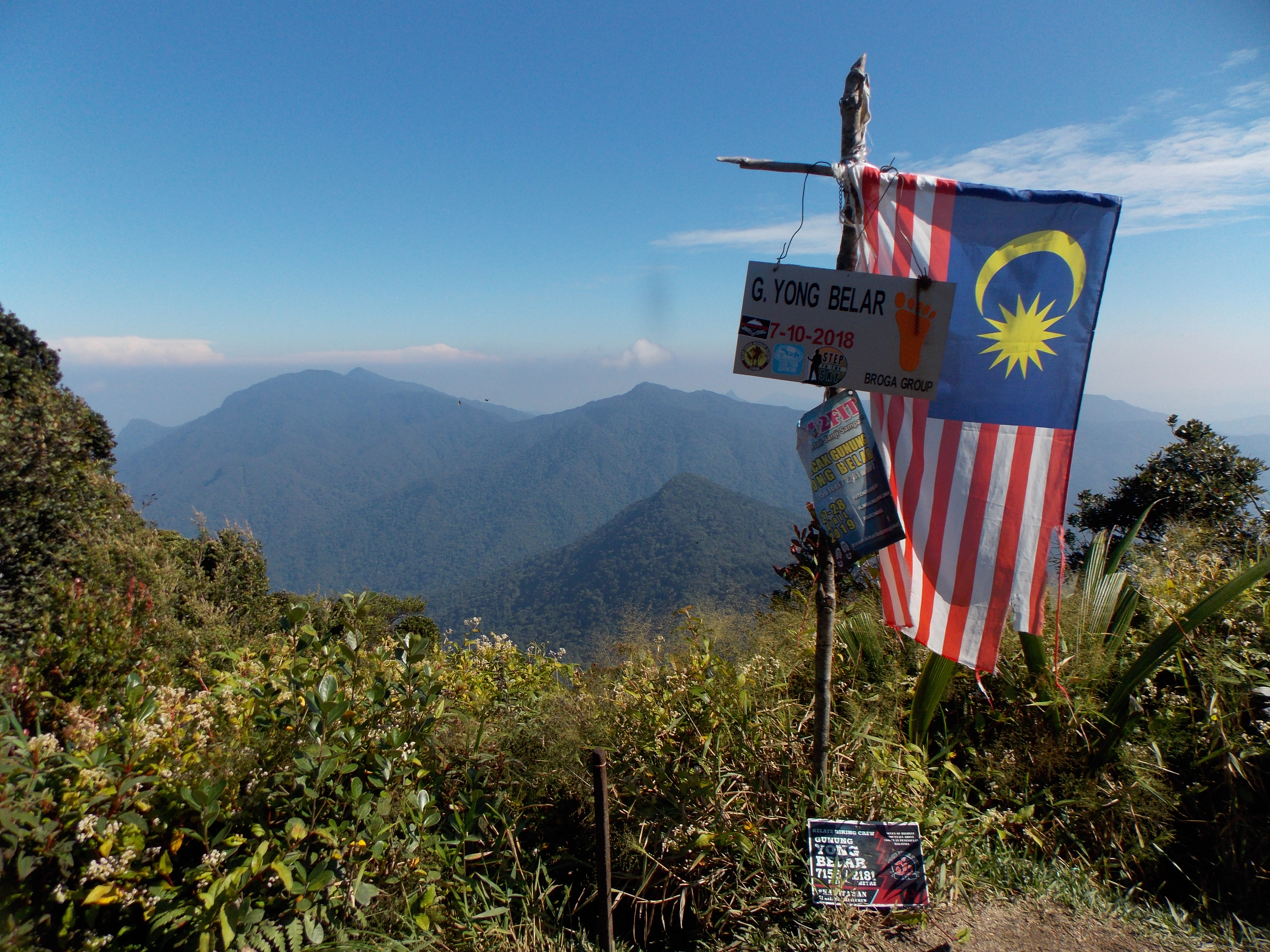
Mount Yong Belar ( ms, Gunung Yong Belar, Jawi: ڬونوڠ يوڠ بلار) is a mountain on the border of the states Kelantan and Perak in the Titiwangsa Mountains of Malaysia. Its summit is above sea level, making it the highest mountain in the state of Kelantan, and the third highest in Peninsular Malaysia, behind Mounts Tahan and Korbu, the latter being located 8 km south. See also * List of mountains of Malaysia * List of Ultras of Southeast Asia This is a list of all the ultra-prominent peaks (with topographic prominence greater than 1,500 metres) in Mainland Southeast Asia. All values below are given in metres. Patkai-Chin Hills Indo-Malayan System Malay Peninsula Annamite Range ... References External links "Gunung Yong Belar, Malaysia" on Peakbagger Yong Belar Yong Belar Titiwangsa Mountains {{Perak-geo-stub ... [...More Info...] [...Related Items...] OR: [Wikipedia] [Google] [Baidu] |
Cameron Highlands
The Cameron Highlands ( ms, Tanah Tinggi Cameron, , ta, கேமரன் மலை) is a district in Pahang, Malaysia, occupying an area of . To the north, its boundary touches that of Kelantan; to the west, it shares part of its border with Perak. Situated at the northwestern tip of Pahang, Cameron Highlands is approximately east from Ipoh, roughly north from Kuala Lumpur or about from Kuantan, the capital of Pahang. It is the smallest municipality in the state. Surveyed by the government geologist and explorer William Cameron''Straits Times Weekly Issue'', 22 November 1886, Page 1 in 1885, the outpost consists of three mukims (subdistricts), namely Ringlet, Tanah Rata and Ulu Telom. Its eight settlements are Ringlet, Tanah Rata (the administrative centre), Brinchang, the Bertam Valley, Kea Farm, Tringkap, Kampung Kuala Terla, Kampung Raja and Blue Valley. All are nestled at elevations ranging from to above sea level. Developed in the 1930s, the tableland is one o ... [...More Info...] [...Related Items...] OR: [Wikipedia] [Google] [Baidu] |
Jawi Script
Jawi (; ace, Jawoë; Kelantan-Pattani Malay, Kelantan-Pattani: ''Yawi''; ) is a writing system used for writing several languages of Southeast Asia, such as Acehnese language, Acehnese, Banjar language, Banjarese, Kerinci language, Kerinci, Maguindanao language, Maguindanaon, Malay language, Malay, Minangkabau language, Minangkabau, Tausug language, Tausūg, and Ternate language, Ternate. Jawi is based on the Arabic script, consisting of all of the original 31 Arabic letters, and six additional letters constructed to fit the phonemes native to Malay, and an additional phoneme used in foreign loanwords, but not found in Classical Arabic, which are ''ca'' ( ), ''nga'' ( ), ''pa'' ( ), ''ga'' ( ), ''va'' ( ), and ''nya'' ( ). Jawi was developed from the Spread of Islam in Southeast Asia, advent of Islam in the Maritime Southeast Asia, supplanting the earlier Brahmic scripts used during Hindu-Buddhist era. The oldest evidence of Jawi writing can be found on the 14th century Tere ... [...More Info...] [...Related Items...] OR: [Wikipedia] [Google] [Baidu] |
Titiwangsa Mountains
The Titiwangsa Mountains (Malay: ''Banjaran Titiwangsa,'' بنجرن تيتيوڠسا, ), also known as ''"Banjaran Besar"'' (Big Range) by locals, is the chain of mountains that forms the backbone of the Malay Peninsula. The northern section of the range is in southern Thailand, where it is known as Sankalakhiri Range ( th, ทิวเขาสันกาลาคีรี, ). The range acts as a natural divider, dividing Peninsular Malaysia, as well as southernmost Thailand, into east and west coast regions. It is also the source of some major rivers of Peninsular Malaysia such as the Pahang, Perak, Kelantan, Klang and Muar. The length of mountain range is about 480 km from north to south. Geology The Titiwangsa Range is part of a suture zone that runs north-south, starting in Thailand at the Nan-Uttaradit suture zone (partly coincident with the Dien Bien Phu fault), and extending south towards Peninsular Malaysia ( Bentong- Raub suture zone). The western half of ... [...More Info...] [...Related Items...] OR: [Wikipedia] [Google] [Baidu] |
Second East-West Highway
The second (symbol: s) is the unit of time in the International System of Units (SI), historically defined as of a day – this factor derived from the division of the day first into 24 hours, then to 60 minutes and finally to 60 seconds each (24 × 60 × 60 = 86400). The current and formal definition in the International System of Units ( SI) is more precise:The second ..is defined by taking the fixed numerical value of the caesium frequency, Δ''ν''Cs, the unperturbed ground-state hyperfine transition frequency of the caesium 133 atom, to be when expressed in the unit Hz, which is equal to s−1. This current definition was adopted in 1967 when it became feasible to define the second based on fundamental properties of nature with caesium clocks. Because the speed of Earth's rotation varies and is slowing ever so slightly, a leap second is added at irregular intervals to civil time to keep clocks in sync with Earth's rotation. Uses Analog clocks and watches often have ... [...More Info...] [...Related Items...] OR: [Wikipedia] [Google] [Baidu] |
Map Of Lojing Sub-district, Kelantan
A map is a symbolic depiction emphasizing relationships between elements of some space, such as objects, regions, or themes. Many maps are static, fixed to paper or some other durable medium, while others are dynamic or interactive. Although most commonly used to depict geography, maps may represent any space, real or fictional, without regard to context or scale, such as in brain mapping, DNA mapping, or computer network topology mapping. The space being mapped may be two dimensional, such as the surface of the earth, three dimensional, such as the interior of the earth, or even more abstract spaces of any dimension, such as arise in modeling phenomena having many independent variables. Although the earliest maps known are of the heavens, geographic maps of territory have a very long tradition and exist from ancient times. The word "map" comes from the , wherein ''mappa'' meant 'napkin' or 'cloth' and ''mundi'' 'the world'. Thus, "map" became a shortened term referring to ... [...More Info...] [...Related Items...] OR: [Wikipedia] [Google] [Baidu] |
Shorea
Fruit of a ''Shorea'' species ''Shorea'' is a genus of about 196 species of mainly rainforest trees in the family Dipterocarpaceae. The genus is named after Sir John Shore, the governor-general of the British East India Company, 1793–1798. The timber of trees of the genus is sold under the common names lauan, luan, lawaan, meranti, seraya, balau, bangkirai, and Philippine mahogany. Taxonomy ''Shorea'' fossils (linked with the modern sal, ''S. robusta'', which is still a dominant tree species in Indian forests) are known from as early as the Eocene of Gujarat, India. They are identifiable by the amber fossils formed by their Dammar gum, dammar resin. Other fossils include a Miocene-aged fossilized fruit from the same region; this fruit most closely resembles the extant ''Shorea macroptera, S. macroptera'' of the Malay Peninsula. Description ''Shorea'' spp. are native to Southeast Asia, from northern India to Malaysia, Indonesia, and the Philippines. In west Malesia and th ... [...More Info...] [...Related Items...] OR: [Wikipedia] [Google] [Baidu] |
Teak
Teak (''Tectona grandis'') is a tropical hardwood tree species in the family Lamiaceae. It is a large, deciduous tree that occurs in mixed hardwood forests. ''Tectona grandis'' has small, fragrant white flowers arranged in dense clusters (panicles) at the end of the branches. These flowers contain both types of reproductive organs ( perfect flowers). The large, papery leaves of teak trees are often hairy on the lower surface. Teak wood has a leather-like smell when it is freshly milled and is particularly valued for its durability and water resistance. The wood is used for boat building, exterior construction, veneer, furniture, carving, turnings, and other small wood projects. ''Tectona grandis'' is native to south and southeast Asia, mainly Bangladesh, India, Indonesia, Malaysia, Myanmar, Thailand and Sri Lanka, but is naturalised and cultivated in many countries in Africa and the Caribbean. Myanmar's teak forests account for nearly half of the world's naturally occurring teak. ... [...More Info...] [...Related Items...] OR: [Wikipedia] [Google] [Baidu] |


