|
List Of Sovereign States In 1775
Sovereign states A * Adal ‚Äì Adal Sultanate * Algiers ‚Äì Sultanate of Algiers *Alipura ‚Äì Alipura * ‚Äì Principality of Andorra * Anhalt ‚Äì Principality of Anhalt * Annam ‚Äì Empire of Annam *Ansbach ‚Äì Principality of Ansbach * Arakan ‚Äì Kingdom of Arakan * ‚Äì Asante Union *Assam ‚Äì Kingdom of Assam * Atjeh ‚Äì Aceh Sultanate * Austria ‚Äì Archduchy of Austria B * Baden ‚Äì Margraviate of Baden * ‚Äì Kingdom of Bali *Bamana ‚Äì Bamana Empire * Banten ‚Äì Sultanate of Banten * Bavaria ‚Äì Duchy of Bavaria * ‚Äì Benin Empire * Bhonsle ‚Äì Kingdom of Bhonsle *Bhutan ‚Äì Kingdom of Bhutan * Bornu ‚Äì Bornu Empire * ‚Äì Sultanate of Brunei * ‚Äì Brunswick-Wolfenb√ºttel * Bukhara ‚Äì Khanate of Bukhara * Burma ‚Äì Kingdom of Burma C * Carnatic ‚Äì Kingdom of Carnatic *Cayor ‚Äì Kingdom of Cayor *Champa ‚Äì Kingdom of Champa * Champasak ‚Äì Kingdom of Champasak *China ‚Äì Great Qing Empire *Cologne ‚Äì Electorate of Cologne *Comancheria ‚Äì N âm ân â â Sookobit â * Cospaia ... [...More Info...] [...Related Items...] OR: [Wikipedia] [Google] [Baidu] |
Adal Sultanate
The Adal Sultanate, or the Adal Empire or the øAdal or the Bar Sa øad dƒ´n (alt. spelling ''Adel Sultanate, ''Adal ''Sultanate'') () was a medieval Sunni Muslim Empire which was located in the Horn of Africa. It was founded by Sabr ad-Din II after the fall of the Sultanate of Ifat. The kingdom flourished circa 1415 to 1577.. The sultanate and state were established by the local inhabitants of Zeila. or the Harar plateau. At its height, the polity under Sultan Badlay controlled the territory stretching from Somaliland to the port city of Suakin in Sudan. The Adal Empire maintained a robust commercial and political relationship with the Ottoman Empire. Etymology Adal is believed to be an abbreviation of Havilah. Eidal or Aw Abdal, was the Emir of Harar in the eleventh century. In the thirteenth century, the Arab writer al-Dimashqi refers to the Adal Sultanate's capital, Zeila, by its Somali name "Awdal" ( so, "Awdal"). The modern Awdal region of Somaliland, which was p ... [...More Info...] [...Related Items...] OR: [Wikipedia] [Google] [Baidu] |
Denmark–Norway
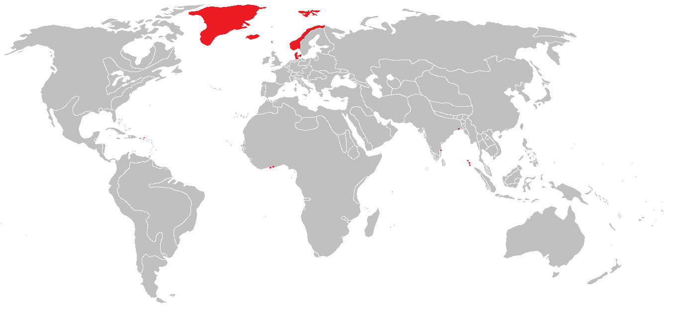
Denmark–Norway (Danish and Norwegian: ) was an early modern multi-national and multi-lingual real unionFeldbæk 1998:11 consisting of the Kingdom of Denmark, the Kingdom of Norway (including the then Norwegian overseas possessions: the Faroe Islands, Iceland, Greenland, and other possessions), the Duchy of Schleswig, and the Duchy of Holstein.Feldbæk 1998:21f, 125, 159ff, 281ff The state also claimed sovereignty over three historical peoples: Frisians, Gutes and Wends.Feldbæk 1998:21 Denmark–Norway had several colonies, namely the Danish Gold Coast, the Nicobar Islands, Serampore, Tharangambadi, and the Danish West Indies.Feldbæk 1998:23 The union was also known as the Dano-Norwegian Realm (''Det dansk-norske rige''), Twin Realms (''Tvillingerigerne'') or the Oldenburg Monarchy (''Oldenburg-monarkiet'') The state's inhabitants were mainly Danes, Norwegians and Germans, and also included Faroese, Icelanders and Inuit in the Norwegian overseas possessions, a Sami minori ... [...More Info...] [...Related Items...] OR: [Wikipedia] [Google] [Baidu] |
Dendi Kingdom
The Dendi (or Dandi, Dendiganda) was a former province of the Songhai Empire. Its centers today are the cities of Gaya in Niger, Kamba in Nigeria and Malanville in Benin Dendi Kingdom Under the Songhai empire, Dendi had been the easternmost province, governed by the prestigious ''Dendi-fari'' ("governor of the eastern front"). Some of the Askia dynasty and its followers fled to here after the defeated by the invading Saadi dynasty of Morocco at the Battle of Tondibi and at another battle seven months later. There, they resisted Moroccan Invaders and maintained the tradition of the Songhai with the same Askia rulers and its newly established capital as Lulami. The first ruler who was Askia Ishaq II was deposed by his brother Muhammad Gao, who was in turn murdered on the order of the Moroccan pasha. The Moroccans then appointed Sulayman as puppet king ruling the Niger between Djenné and Gao. South of Tillaberi the Songhai resistance against Morocco continued under Askia Nuh, a ... [...More Info...] [...Related Items...] OR: [Wikipedia] [Google] [Baidu] |
Crimean Khanate
The Crimean Khanate ( crh, , or ), officially the Great Horde and Desht-i Kipchak () and in old European historiography and geography known as Little Tartary ( la, Tartaria Minor), was a Crimean Tatars, Crimean Tatar state existing from 1441 to 1783, the longest-lived of the Turkic khanates that succeeded the empire of the Golden Horde. Established by Hacı I Giray in 1441, it was regarded as the direct heir to the Golden Horde and to Cumania, Desht-i-Kipchak. In 1783, violating the 1774 Treaty of Küçük Kaynarca (which had guaranteed non-interference of both Russia and the Ottoman Empire in the affairs of the Crimean Khanate), the Russian Empire Annexation of Crimea by the Russian Empire, annexed the khanate. Among the European powers, only France came out with an open protest against this act, due to the longstanding Franco-Ottoman alliance. Naming and geography Crimean khans, considering their state as the heir and legal successor of the Golden Horde and Desht-i Kipchak, ... [...More Info...] [...Related Items...] OR: [Wikipedia] [Google] [Baidu] |
Republic Of Cospaia
The Republic of Cospaia (local dialect: ''Republica de' Cošpäja'') was a small state within modern-day Italy, located in northern Umbria, independent from 1440 to 1826. It was located in what is now the hamlet (''frazione'') of Cospaia in the comune of San Giustino in the Province of Perugia. History It unexpectedly gained independence in 1440 after Pope Eugene IV, embroiled in a struggle with the Council of Basel, made a sale of territory to the Republic of Florence. By error, a small strip of land went unmentioned in the sale treaty and its inhabitants declared themselves independent. The misunderstanding arose from the fact that, about 500 meters from the stream that was to establish the demarcation (simply called "Rio"), there was another stream with the same name. The delegates of the Florentine republic considered the "Rio" which was located further north as the new delimitation, whereas the delegates of the Papal States considered it the one further south. Thus a sort of ... [...More Info...] [...Related Items...] OR: [Wikipedia] [Google] [Baidu] |
Comancheria
The Comancheria or Comancher√≠a (Comanche: N âm ân â â Sookobit â, 'Comanche land') was a region of New Mexico, west Texas and nearby areas occupied by the Comanche before the 1860s. Historian Pekka H√§m√§l√§inen has argued that the Comancheria formed an empire at its peak, and this view has been echoed by other non-Comanche historians. Geography The area was vaguely defined and shifted over time but generally was described as bordered to the south by the Balcones Fault, just north of San Antonio, Texas, continuing north along the Cross Timbers to encompass a northern area that included the Cimarron River and the upper Arkansas River east of the Rocky Mountains. Comancher√≠a was bordered along the west by the Mescalero Ridge and the Pecos River, continuing north along the edge of the Spanish settlements in Santa Fe de Nuevo M√©xico. It also included West Texas, the Llano Estacado, the Texas Panhandle, the Edwards Plateau (including the Texas Hill Country), Eastern New Mexico, we ... [...More Info...] [...Related Items...] OR: [Wikipedia] [Google] [Baidu] |
Electorate Of Cologne
The Electorate of Cologne (german: Kurfürstentum Köln), sometimes referred to as Electoral Cologne (german: Kurköln, links=no), was an ecclesiastical principality of the Holy Roman Empire that existed from the 10th to the early 19th century. It consisted of the Hochstift — the temporal possessions — of the Archbishop of Cologne, and was ruled by him in his capacity as prince-elector. There were only two other ecclesiastical prince-electors in the Empire: the Electorate of Mainz and the Electorate of Trier. The Archbishop-Elector of Cologne was also Arch-chancellor of Italy (one of the three component titular kingdoms of the Holy Roman Empire, the other two being Germany and Burgundy) and, as such, ranked second among all ecclesiastical and secular princes of the Empire, after the Archbishop-Elector of Mainz, and before that of Trier. The capital of the electorate was Cologne. Conflicts with the citizens of Cologne caused the Elector to move to Bonn. The Free Imperial C ... [...More Info...] [...Related Items...] OR: [Wikipedia] [Google] [Baidu] |
Qing Dynasty
The Qing dynasty ( ), officially the Great Qing,, was a Manchu-led imperial dynasty of China and the last orthodox dynasty in Chinese history. It emerged from the Later Jin dynasty founded by the Jianzhou Jurchens, a Tungusic-speaking ethnic group who unified other Jurchen tribes to form a new "Manchu" ethnic identity. The dynasty was officially proclaimed in 1636 in Manchuria (modern-day Northeast China and Outer Manchuria). It seized control of Beijing in 1644, then later expanded its rule over the whole of China proper and Taiwan, and finally expanded into Inner Asia. The dynasty lasted until 1912 when it was overthrown in the Xinhai Revolution. In orthodox Chinese historiography, the Qing dynasty was preceded by the Ming dynasty and succeeded by the Republic of China. The multiethnic Qing dynasty lasted for almost three centuries and assembled the territorial base for modern China. It was the largest imperial dynasty in the history of China and in 1790 the f ... [...More Info...] [...Related Items...] OR: [Wikipedia] [Google] [Baidu] |
Kingdom Of Champasak
The Kingdom of Champasak (Lao: ý∫àý∫≥ý∫õý∫≤ý∫™ý∫±ý∫Å …ï√Ýmp√ÝÀês√°k or Bassac, (1713‚Äì1904) was a Lao kingdom under Nokasad, a grandson of King Sourigna Vongsa, the last king of Lan Xang and son-in-law of the Cambodian King Chey Chettha IV. Bassac and the neighboring principalities of Attapeu and Stung Treng emerged as power centers under what was later to be described as the Mandala Southeast Asian political model. History The kingdom was sited on the eastern or Left Bank of the Mekong, south of the Right Bank principality of Khong Chiam where the Mun River joins; and east of where the Mekong makes a sharp bend to the west to return abruptly and flow southeasterly down to what is now Cambodia. Due to scarcity of information from the periods known as the Post-Angkor Period, the Khorat Plateau seems to have been largely depopulated, and Left Bank principalities began to repopulate the Right. In 1718, a Lao emigration in the company of an official in the service of ... [...More Info...] [...Related Items...] OR: [Wikipedia] [Google] [Baidu] |
Champa
Champa (Cham: Í®åÍ©åÍ®õÍ®©; km, ·ûÖ·û∂·ûò·üí·ûî·üâ·û∂; vi, Chi√™m Th√Ýnh or ) were a collection of independent Cham polities that extended across the coast of what is contemporary central and southern Vietnam from approximately the 2nd century AD until 1832, when it was annexed by the Vietnamese Empire under its emperor Minh M·∫°ng. The kingdom was known variously as ''Nagaracampa'' ( sa, ý§®ý§óý§∞ý§öý§Æý•çý§™ý§É), ''Champa'' (Í®åÍ©åÍ®õÍ®©) in modern Cham, and ''Ch√¢mpa'' () in the Khmer inscriptions, ''Chi√™m Th√Ýnh'' in Vietnamese and ''Zh√Ýnch√©ng'' (Mandarin: ÂçÝÂüé) in Chinese records. The Kingdoms of Champa and the Chams contribute profound and direct impacts to the history of Vietnam, Southeast Asia, as well as their present day. Early Champa, evolved from local seafaring Austronesian Chamic Sa Hu·ª≥nh culture off the coast of modern-day Vietnam. The emergence of Champa at the late 2nd century AD shows testimony of early Southeast Asian statecrafting and crucial ... [...More Info...] [...Related Items...] OR: [Wikipedia] [Google] [Baidu] |
Cayor
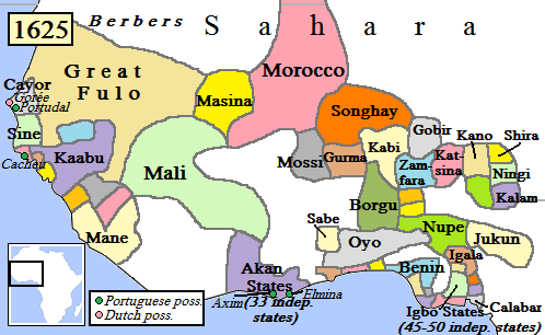
Cayor ( wo, Kajoor; ar, كاجور) was the largest and most powerful kingdom (1549–1879) that split off from the Jolof Empire in what is now Senegal. Cayor was located in northern and central Senegal, southeast of Walo, west of the kingdom of Jolof, and north of Baol and the Kingdom of Sine. History In 1549, the damel (''dammeel'' in Wolof, often translated into European languages as "king") Dece Fu Njogu became independent from Jolof and set Cayor's capital at Mboul. The French, under governor Louis Faidherbe, annexed Cayor in 1868; Cayor re-established independence in 1871. France invaded again and annexed Cayor again in 1879, when it ceased to be a sovereign state. The kingdom was extinguished in its entirety October 6, 1886. In addition to Cayor, the damels also ruled over the Lebou area of Cap-Vert (where modern Dakar is), and they became the " Teignes" (rulers) of the neighboring kingdom of Baol. Traditionally the damel himself was not purely hereditary, but was de ... [...More Info...] [...Related Items...] OR: [Wikipedia] [Google] [Baidu] |


