|
Kinmen Airport
Kinmen Shangyi Airport () is a civilian airport serving Kinmen, Fujian Province, Republic of China. It is located at Jinhu Township of Kinmen County. It was authorized to become a C-class airport under the direct supervision of the Civil Aeronautics Administration, Ministry of Transportation and Communications of the Executive Yuan. It serves an average of 1.2 million passengers every year. With the direct Cross-Strait flights between mainland China and Taiwan being expensive compared to domestic fares for each side respectively, this makes travel via Kinmen with an hourly short thirty-minute ferry ride to Xiamen's Wutong Ferry Terminal, close to Xiamen Gaoqi International Airport, very popular. Check-in facilities for Kinmen Airport flights exists within the Wutong Ferry Terminal to assist in travel from the mainland to Taiwan. History Kinmen Airport was originally established in 1949 in Sihung Village. In June 1951, the Ministry of National Defense ratified TransAsia Airw ... [...More Info...] [...Related Items...] OR: [Wikipedia] [Google] [Baidu] |
Civil Aeronautics Administration (Taiwan)
The Civil Aeronautics Administration (CAA; ) is a government agency of the Ministry of Transportation and Communications of the Republic of China, Taiwan, which is responsible for the regulation of all civil aviation activities. CAA operates the passenger terminals in 18 airports, of which 9 airports are owned by CAA, with the rest owned by the Republic of China Air Force. History The agency was established on January 20, 1947. Organizational structure * Logistic Division * Aerodrome Engineering Division * Air Navigation Facilities Division * Air Traffic Services Division * Flight Standards Division * Air Traffic Division * Planning, Legal and International Affair Division * Civil Service Ethics Office * Budget, Accounting and Statistics Office * Personnel Office * Secretariat * Information Management Office Airports operated by CAA International * Kaohsiung International Airport * Taichung International Airport * Taipei Songshan Airport Domestic * Chiayi Airport * ... [...More Info...] [...Related Items...] OR: [Wikipedia] [Google] [Baidu] |
Elevation
The elevation of a geographic location is its height above or below a fixed reference point, most commonly a reference geoid, a mathematical model of the Earth's sea level as an equipotential gravitational surface (see Geodetic datum § Vertical datum). The term ''elevation'' is mainly used when referring to points on the Earth's surface, while '' altitude'' or '' geopotential height'' is used for points above the surface, such as an aircraft in flight or a spacecraft in orbit, and '' depth'' is used for points below the surface. Elevation is not to be confused with the distance from the center of the Earth. Due to the equatorial bulge, the summits of Mount Everest and Chimborazo have, respectively, the largest elevation and the largest geocentric distance. Aviation In aviation the term elevation or aerodrome elevation is defined by the ICAO as the highest point of the landing area. It is often measured in feet and can be found in approach charts of the aerodrome ... [...More Info...] [...Related Items...] OR: [Wikipedia] [Google] [Baidu] |
Kaohsiung International Airport
Kaohsiung International Airport () is a medium-sized civil airport in Siaogang District, Kaohsiung, Taiwan, also known as Siaogang Airport (). With nearly seven million passengers in 2018, it is the second busiest airport in Taiwan, after Taoyuan. The airport has a single east–west runway and two terminals: one international and one domestic. History Originally built as an Imperial Japanese Army Air Squadron base in 1942 during the Japanese rule era of Taiwan, Kaohsiung Airport retained its military purpose when the Republic of China government first took control of Taiwan in 1945. Due to the need for civil transportation in southern Taiwan, it was demilitarised and converted into a domestic civil airport in 1965, and further upgraded to the status an international airport in 1969, with regular international flights starting in 1972. During the 1970s and 1980s, direct international flights were rare at the airport, with Hong Kong and Tokyo being the only two destinatio ... [...More Info...] [...Related Items...] OR: [Wikipedia] [Google] [Baidu] |
Chiayi Airport
Chiayi Airport () , commonly known as Shueishang Airport (), is an airport in Shuishang Township, Chiayi County, Taiwan. The airport has one runway, and it is used as a civilian airport and is co-located next to Chiayi Air Base. Chiayi Airport is envisioned as a gateway to the Alishan National Scenic Area, a popular tourist destination in Taiwan. Opened in 1976, Chiayi Airport was one of the airports in Taiwan that were severely affected by the opening of the Taiwan High Speed Rail in 2007. Uni Air is the sole operator of scheduled flights to the airport. Although listed as an international airport by the Taiwanese government, the joint use of Chiayi Airport's facilities by the Republic of China Air Force and the lack of complete customs and immigration facilities at the airport restricts the use of the airport by international flights. As such, the airport has no scheduled international flights; it is only served internationally by occasional chartered flights. History A dep ... [...More Info...] [...Related Items...] OR: [Wikipedia] [Google] [Baidu] |
Taipei-Songshan
Taipei Songshan Airport is a regional airport and military airbase located in Songshan District, Taipei, Taiwan. The airport covers an area of . The civilian section of Songshan Airport has scheduled flights to domestic destinations in Taiwan and international destinations including Seoul, Tokyo, and select cities in mainland China. Songshan serves only a small portion of the international flights for Taipei compared to the larger Taoyuan International Airport. Songshan Airport is also the base of certain Republic of China Air Force units as part of the Songshan Air Force Base. The Songshan Base Command's main mission is to serve the President and Vice President of the Republic of China. History The airport was built in 1936 during Japanese rule with its origins as a Japanese military airbase, the , also known as . After World War II, in 1946, it was taken over by the Republic of China Air Force. Before the end of the Chinese Civil War and the establishment of the People's ... [...More Info...] [...Related Items...] OR: [Wikipedia] [Google] [Baidu] |
Taichung Airport
Taichung International Airport () , is an international airport located in Taichung, Taiwan, which is used for both commercial and military purposes. It is also the third international airport in Taiwan, with scheduled services to China, Hong Kong, Japan, Macao, South Korea, Thailand and Vietnam. History Taichung International Airport was constructed during the era of Japanese rule and was named . The United States Air Force (USAF) had been garrisoning the base with two fighter squadrons until the Sino-American Mutual Defense Treaty came into force on March 3, 1955. The airport then expanded in 1954 according to the Sino-American Mutual Defense Treaty, and later renamed Ching Chuan Kang Air Base (CCK) after General Qiu Qingquan. In 1966 the American Air Force established a joint forces air-base at CCK. It was the largest air force base in the Far East at the time, allowing Boeing B-52 Stratofortress bombers to land. During the Vietnam War, CCK became a depot for the USAF. ... [...More Info...] [...Related Items...] OR: [Wikipedia] [Google] [Baidu] |
Mandarin Airlines
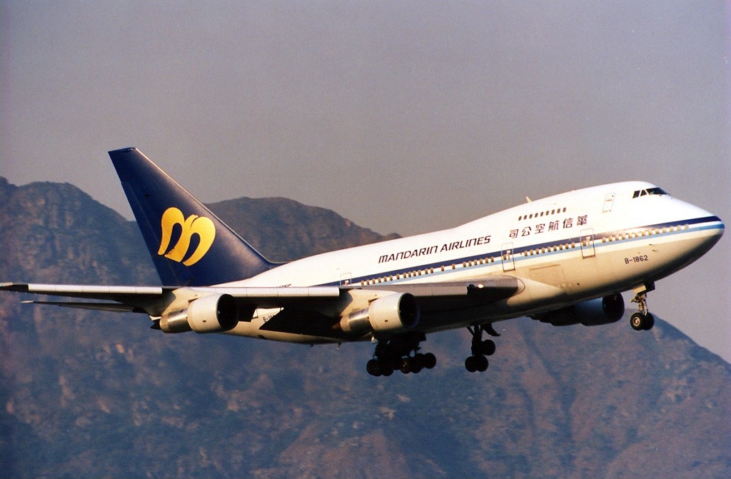
Mandarin Airlines () is a Taiwanese regional airline based in Taipei, Taiwan, whose parent company is China Airlines. The airline operates domestic and regional international flights, while its parent company focuses on international operations. Some charter services are also operated by the company. Its main base is Taipei Songshan Airport, Taichung International Airport and Kaohsiung International Airport. History Mandarin Airlines was established on 1 June 1991, and was initially a joint venture by China Airlines (67%) and Koos Group (33%); the Chinese name of the company is formed by the combination of the two.About Us " ''Mandarin Airlines''. Retrieved on 7 March 2010. The establishment of Mandarin Airlines is closely related to the |
List Of Area Control Centers
Area control centers (ACCs) control IFR air traffic in their flight information region (FIR). The current list of FIRs and ACCs is maintained by the International Civil Aviation Organization (ICAO). Note that the cited ICAO source gives the shapefile coordinates for each FIR, and also its page source gives a list of current ACCs in text form. The following is the alphabetic list of all ACCs and their FIRs : See also * |
CAAC
The Civil Aviation Administration of China (CAAC; ) is the Chinese civil aviation authority under the Ministry of Transport. It oversees civil aviation and investigates aviation accidents and incidents. As the aviation authority responsible for China, it concludes civil aviation agreements with other aviation authorities, including those of the Special administrative regions of China which are categorized as "special domestic." It directly operated its own airline, China's aviation monopoly, until 1988. The agency is headquartered in Dongcheng District, Beijing. The CAAC does not share the responsibility of managing China's airspace with the Central Military Commission under the regulations in the Civil Aviation Law of the People's Republic of China. History On November 2, 1949, shortly after the founding of the People's Republic of China, the CCP Central Committee decided to found the Civil Aviation Agency under the name of the People's Revolutionary Military Commission, ... [...More Info...] [...Related Items...] OR: [Wikipedia] [Google] [Baidu] |
Instrument Landing System
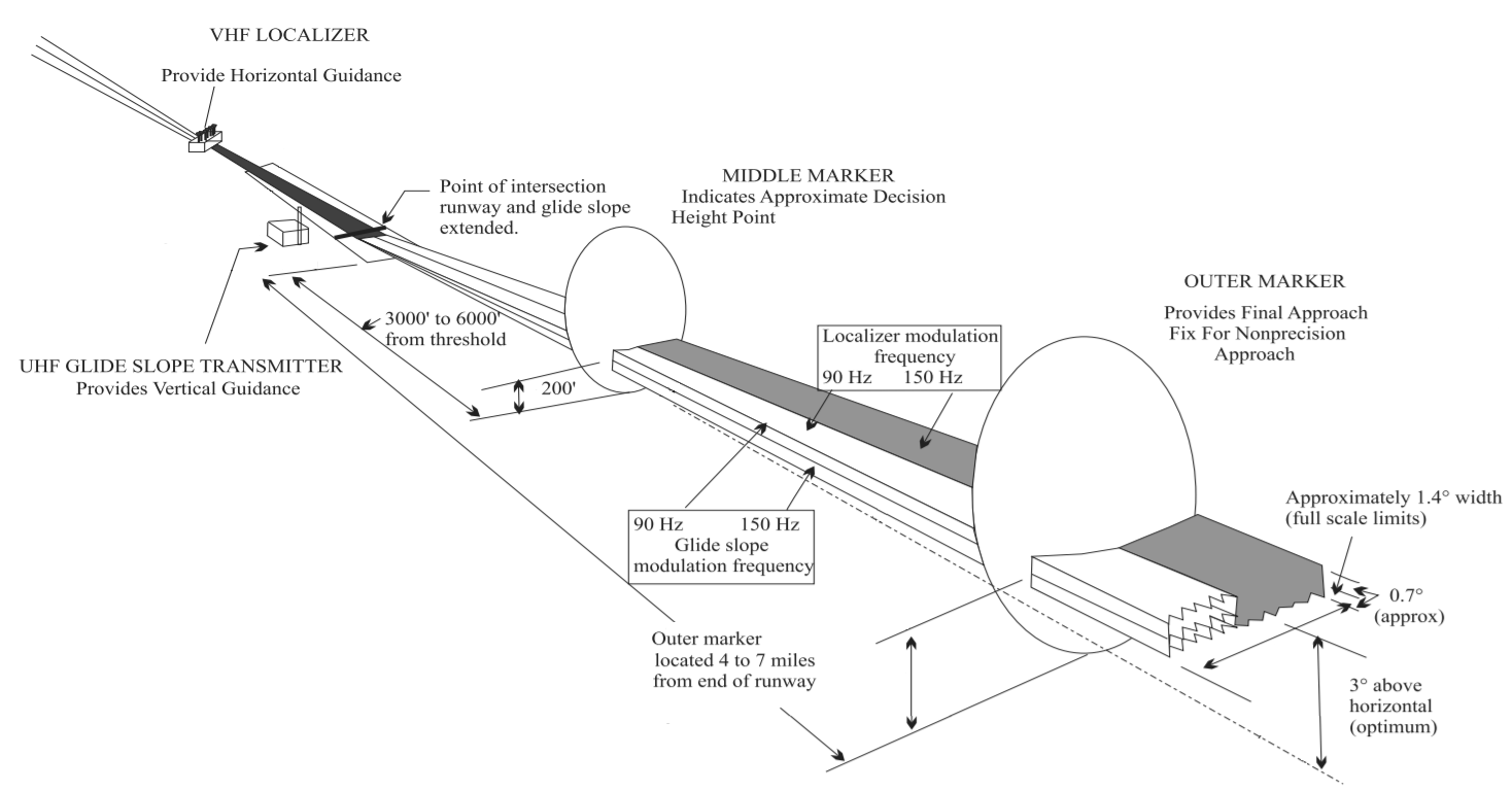
In aviation, the instrument landing system (ILS) is a precision radio navigation system that provides short-range guidance to aircraft to allow them to approach a runway at night or in bad weather. In its original form, it allows an aircraft to approach until it is over the ground, within a of the runway. At that point the runway should be visible to the pilot; if it is not, they perform a missed approach. Bringing the aircraft this close to the runway dramatically increases the range of weather conditions in which a safe landing can be made. Other versions of the system, or "categories", have further reduced the minimum altitudes, runway visual ranges (RVRs), and transmitter and monitoring configurations designed depending on the normal expected weather patterns and airport safety requirements. ILS uses two directional radio signals, the ''localizer'' (108 to 112 MHz frequency), which provides horizontal guidance, and the ''glideslope'' (329.15 to 335 MHz frequenc ... [...More Info...] [...Related Items...] OR: [Wikipedia] [Google] [Baidu] |
Approach Lighting System
An approach lighting system (ALS) is a lighting system installed on the approach end of an airport runway and consisting of a series of lightbars, strobe lights, or a combination of the two that extends outward from the runway end. ALS usually serves a runway that has an instrument approach procedure (IAP) associated with it and allows the pilot to visually identify the runway environment and align the aircraft with the runway upon arriving at a prescribed point on an approach. Modern approach lighting systems are highly complex in their design and significantly enhance the safety of aircraft operations, particularly in conditions of reduced visibility. Operation The required minimum visibilities for instrument approaches is influenced by the presence and type of approach lighting system. In the U.S., a CAT I ILS approach without approach lights will have a minimum required visibility of 3/4 mile, or 4000 foot runway visual range. With a 1400-foot or longer approach light sy ... [...More Info...] [...Related Items...] OR: [Wikipedia] [Google] [Baidu] |


