|
Kajuru
Kajuru ( Adara: Ajure) is a local government area in southern Kaduna State, Nigeria. Its headquarters is in the town of Kajuru. The local government is located on longitude 9° 59'N and 10° 55'N and latitude 7° 34'E and 8° 13'E, with an area of 2,229 km2. History It was carved out of Chikun Local Government Area in March 1997 by the military administration of Gen. Sani Abacha's regime. At creation, it was made up of two traditional districts, Kajuru and Kufana. Additional districts were created, bringing the number to 14 districts (Toro 2001), now 10. Boundaries Kajuru local government shares boundaries with Igabi Local Government Area to the north, Chikun Local Government Area to the west, Kauru Local Government Area to the east, Zangon Kataf Local Government Area and Kachia Local Government Area to the south-west and south respectively. Administrative subdivisions Kajuru Local Government Area consists of 10 subdivisions (second-order administrative divisions), namely: # ... [...More Info...] [...Related Items...] OR: [Wikipedia] [Google] [Baidu] |
Kajuru Castle
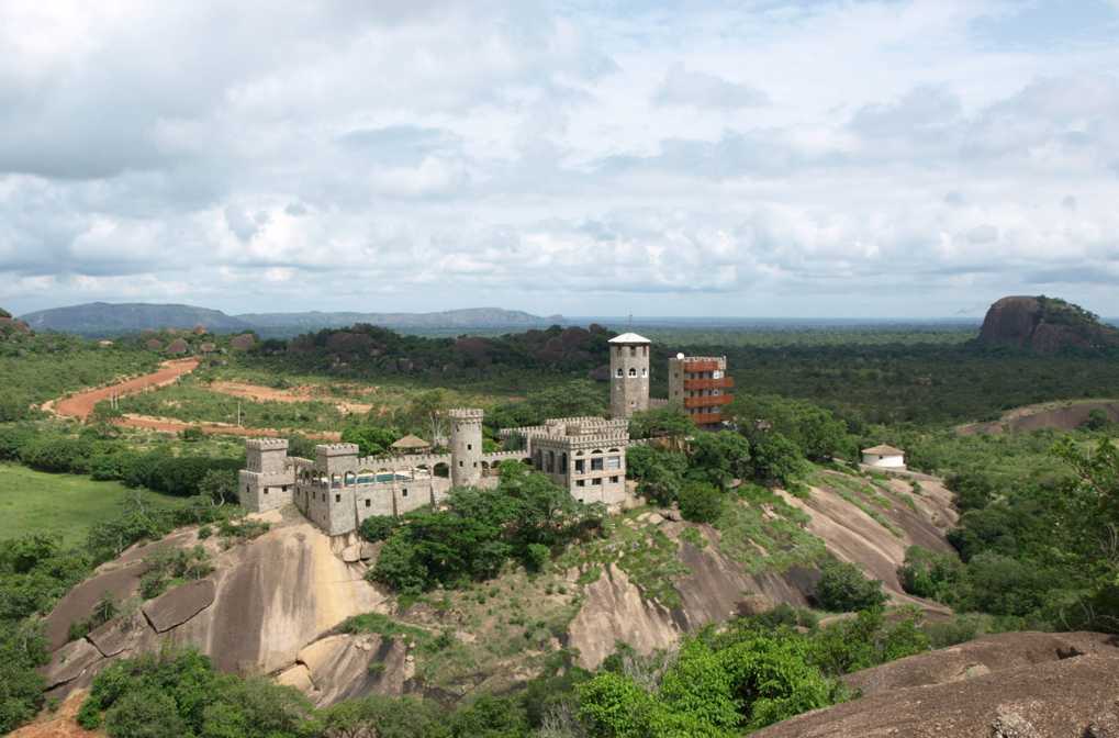
Kajuru Castle is a luxury villa, built between the years 1981 and 1989, at Kajuru (Ajure) village in southern Kaduna State, Nigeria. It was built by a German expatriate in Nigeria, living in Kaduna at the time. The castle is located at about 45 km from Kaduna on a mountaintop in Kajuru (Ajure) village, Kaduna State. Built with 1 meter thick granite stone in a fanciful medieval-inspired Romanesque style, it is adorned with turrets, an armory and a dungeon. The castle is privately owned, and has the capacity to host 150 guests. Architecture The castle is often described as an African version of the Bavarian Castle in a grand 19th-century Romanesque revival style. It has a baronial styled hall, coupled with dungeons and towers lined with crenellated walls. The castle also has a big “knight’s hall” and a landlord (masters) residence and several other rooms over its three floors. Incident On 19 April 2019, unidentified terrorists armed with heavy weapons broke into ... [...More Info...] [...Related Items...] OR: [Wikipedia] [Google] [Baidu] |
Kaduna State
Kaduna State ( ha, Jihar Kaduna جىِهَر كَدُنا; ff, Leydi Kaduna, script=Latn, ; kcg, Sitet Kaduna) is a state in northern Nigeria. The state capital is its namesake, the city of Kaduna which happened to be the 8th largest city in the country as at 2006. Created in 1967 as North-Central State, which also encompassed the modern Katsina State, Kaduna State achieved its current borders in 1987. The fourth largest and third most populous state in the country, Kaduna State is nicknamed the ''Centre of Learning'', owing to the presence of numerous educational institutions of importance within the state such as Ahmadu Bello University. Modern Kaduna State is home to the sites of some of Africa's oldest civilizations, including the Nok civilization that prospered from to .Breunig, Peter. 2014. Nok: African Sculpture in Archaeological Context: p. 21.Fagg, Bernard. 1969. Recent work in west Africa: New light on the Nok culture. World Archaeology 1(1): 41–50. In the 9th ... [...More Info...] [...Related Items...] OR: [Wikipedia] [Google] [Baidu] |
Southern Kaduna
Southern Kaduna (formerly Southern Zaria) is an area inhabited by various non-Hausa peoples living south of Zaria Emirate of Kaduna State. It is located in the Middle Belt region of Nigeria. Southern Kaduna consist of 12 local Government out of Kaduna State 23 Local Government. Some view it as being less of a geographical identity and more of an ethnic identity concept. Subdivisions * Chikun * Jaba * Jema'a * Kachia * Kaduna South * Kagarko * Kajuru * Kaura * Kauru * Lere * Sanga * Zangon Kataf Ethnic composition Southern Kaduna is composed of closely related ethnic groups and several subgroups united by a common culture and history. James (2000) classified these people based on their ethno-linguistic affinities under the topic "The Middle Belt (Composition of the Nok Culture Area)", and grouping the subgroups into the following groups: the Southern kaduna population is estimated to be over 4.5 million people out of the estimated 8.5 million population in Kaduna state ... [...More Info...] [...Related Items...] OR: [Wikipedia] [Google] [Baidu] |
Adara People
Adara people (also Eda and ''Kadara''), are an ethnic group in the Middle Belt who speak the Adara language, a north Plateau languages, Plateau language of Nigeria. Dio Awemi Maisamari is the National president of Adara Development Association (ADA) with his assistant Luke Waziri assistant secretary of the association. Demographics Some estimates place the population of the Adara people at around 381,000. About 55% of the Adara are Christians while some also adhere to Islam. Location Adara people can be found in the sub-saharan African Countries and they are only found in Nigeria. They can be found in Benue State, Benue and some parts of Kaduna state like Kajuru and Kachia local government areas. Communities along the area include Magunguna, Idazo, Ungwan Galadima, Ungwan Guza, Etissi, Ungwan Ma’aji, Ungwan Dantata, Ungwan Araha 1 & 2, Ungwan Goshi, Ungwan Shaban, Ungwan Jibo, Ungwan Maijama’a, Ungwan Sako, Ungwan Maidoki and Ungwan Masaba. Crises Adara people have suffer ... [...More Info...] [...Related Items...] OR: [Wikipedia] [Google] [Baidu] |
Chikun
Chikun is a Local Government Area in central Kaduna State, Nigeria. It has an area of 4,466 km, and had a population of 372,272 as at the 2006 census. Its headquarters is in the town of Kujama. The postal code of the area is 2438000. Boundaries Chikun Local Government Area shares boundaries with Kachia Local Government Area to the south, Kajuru Local Government Area to the east, Kaduna South Local Government Area to the northeast, Igabi Local Government Area to the northeast, Birnin Gwari Local Government Area to the northwest and Niger State to west, respectively. Administrative subdivisions Chikun Local Government Area consists of 12 subdivisions called Wards (second-order administrative divisions), namely: # Chikun # Gwagwada # Kakau # Kujama # Kunai # Kuriga # Narayi # Nassarawa # Rido # Sabon Gari Nassarawa # Sabon Tasha # Yelwa History Chikun Local Government Area derives its name from a Gbagyi village named Chikun in the southeastern part of Kujama. The area was origin ... [...More Info...] [...Related Items...] OR: [Wikipedia] [Google] [Baidu] |
Kachia
Kachia Hausa Fulani and Kadara and Jaba is a Local Government Area in the southern part of Kaduna State, Nigeria. Its headquarters are in the town of Kachia. It has an area of 4,570 km and a population of 252,568 in the 2006 census. The postal code of the area is 802. Boundaries The Kachia Local Government Area shares boundaries with the Zangon Kataf Local Government Area to the east, the Kajuru Local Government Area to the northeast, the Kagarko Local Government Area to the south, the Jaba, Nigeria, Jaba Local Government Area to the southeast, the Chikun Local Government Area to the northwest, and Niger State to west, respectively. Administrative subdivisions The Kachia Local Government Area consists of 12 subdivisions (second-order administrative divisions) or electoral wards, namely: #Agunu #Ankwa #Awon #Bishini #Dokwa #Gidan Tagwai #Gumel #Kachia #Kateri #Kurmin Musa #Kwaturu #Sabon Sarki (Ghiing) Population According to the March 21, 2006 national population census, the ... [...More Info...] [...Related Items...] OR: [Wikipedia] [Google] [Baidu] |
Zangon Kataf
Zangon Kataf (Tyap language, Tyap: Nietcen-A̱fakan) is a Local Government Areas of Nigeria, Local Government Area in Southern Kaduna, southern Kaduna State, Nigeria. Its headquarters is in the town of Zonkwa. It is also a name of a town (Tyap language, Tyap: Nietcen-A̱fakan) in the Atyap Chiefdom, chiefdom of the Atyap. Other towns include: Batadon (Madakiya), Samaru Kataf, Cenkwon (Samaru Kataf), Kamantan, Anchuna Sarki and Kamuru. It has an area of 2,579 km and a population of 318,991 at the 2006 census. The postal code of the area is 802. Geography Landscape In Zangon Kataf LGA, the mountain with the highest peak is Kacecere (Atyecarak) Hill with a height of 1022m and prominence of 98m. Other mountains are: Kankada Hill (1007m), Bako Hill (949m), Madauci Hill (939m), Ashafa Hill (856m), Kabam Hill (814m), and Antang Hill (742m). Bako Hill, however, has the highest prominence of 155m. Climate Zangon Kataf town and environs have an average annual temperature of about , aver ... [...More Info...] [...Related Items...] OR: [Wikipedia] [Google] [Baidu] |
Kauru
Kauru is a Local Government Area in southern Kaduna State, Nigeria. The area is 3,186 km. Its headquarters are in the town of Kauru. The postal code of the area is 811. Boundaries Kauru Local Government Area shares boundaries with Zangon Kataf Local Government Area to the southwest, Kajuru, Igabi and Soba Local Government Areas to the northwest, Kubau Local Government Area to the north, Lere Local Government Area to the northeast, Kaura Local Government Area to the south and Plateau State to southeast, respectively. Administrative subdivisions Kauru Local Government Area consists of 11 subdivisions (second-order administrative divisions), namely: # Badurum # Bital # Damakasuwa # Dawaki # Geshere # Kamaru # Kauru East # Kauru West # Kwassam # Makami # Pari Population Kauru Local Government Area has an area of 2,810 km, with a population density of 106.3/km 016/small> and annual population change of +3.05%/year. Its population was recorded to be 221,276, based on the March 21, ... [...More Info...] [...Related Items...] OR: [Wikipedia] [Google] [Baidu] |
Igbo People
The Igbo people ( , ; also spelled Ibo" and formerly also ''Iboe'', ''Ebo'', ''Eboe'', * * * ''Eboans'', ''Heebo''; natively ) are an ethnic group in Nigeria. They are primarily found in Abia, Anambra, Ebonyi, Enugu, and Imo States. A sizable Igbo population is also found in Delta and Rivers States. Large ethnic Igbo populations are found in Cameroon, Gabon, and Equatorial Guinea, as well as outside Africa. There has been much speculation about the origins of the Igbo people, which are largely unknown. Geographically, the Igbo homeland is divided into two unequal sections by the Niger River—an eastern (which is the larger of the two) and a western section. The Igbo people are one of the largest ethnic groups in Africa. The Igbo language is part of the Niger-Congo language family. Its regional dialects are somewhat mutually intelligible amidst the larger "Igboid" cluster. The Igbo homeland straddles the lower Niger River, east and south of the Edoid and Idomoid gr ... [...More Info...] [...Related Items...] OR: [Wikipedia] [Google] [Baidu] |
Christianity
Christianity is an Abrahamic monotheistic religion based on the life and teachings of Jesus of Nazareth. It is the world's largest and most widespread religion with roughly 2.38 billion followers representing one-third of the global population. Its adherents, known as Christians, are estimated to make up a majority of the population in 157 countries and territories, and believe that Jesus is the Son of God, whose coming as the messiah was prophesied in the Hebrew Bible (called the Old Testament in Christianity) and chronicled in the New Testament. Christianity began as a Second Temple Judaic sect in the 1st century Hellenistic Judaism in the Roman province of Judea. Jesus' apostles and their followers spread around the Levant, Europe, Anatolia, Mesopotamia, the South Caucasus, Ancient Carthage, Egypt, and Ethiopia, despite significant initial persecution. It soon attracted gentile God-fearers, which led to a departure from Jewish customs, and, a ... [...More Info...] [...Related Items...] OR: [Wikipedia] [Google] [Baidu] |
Inselberg
An inselberg or monadnock () is an isolated rock hill, knob, ridge, or small mountain that rises abruptly from a gently sloping or virtually level surrounding plain. In Southern Africa a similar formation of granite is known as a koppie, an Afrikaans word ("little head") from the Dutch diminutive word ''kopje''. If the inselberg is dome-shaped and formed from granite or gneiss, it can also be called a bornhardt, though not all bornhardts are inselbergs. An inselberg results when a body of rock resistant to erosion, such as granite, occurring within a body of softer rocks, is exposed by differential erosion and lowering of the surrounding landscape. Etymology Inselberg The word ''inselberg'' is a loan word from German, and means "island mountain". The term was coined in 1900 by geologist Wilhelm Bornhardt (1864–1946) to describe the abundance of such features found in eastern Africa. At that time, the term applied only to arid landscape features. However, it has sin ... [...More Info...] [...Related Items...] OR: [Wikipedia] [Google] [Baidu] |
Islam
Islam (; ar, ۘالِإسلَام, , ) is an Abrahamic religions, Abrahamic Monotheism#Islam, monotheistic religion centred primarily around the Quran, a religious text considered by Muslims to be the direct word of God in Islam, God (or ''Allah'') as it was revealed to Muhammad, the Muhammad in Islam, main and final Islamic prophet.Peters, F. E. 2009. "Allāh." In , edited by J. L. Esposito. Oxford: Oxford University Press. . (See alsoquick reference) "[T]he Muslims' understanding of Allāh is based...on the Qurʿān's public witness. Allāh is Unique, the Creator, Sovereign, and Judge of mankind. It is Allāh who directs the universe through his direct action on nature and who has guided human history through his prophets, Abraham, with whom he made his covenant, Moses/Moosa, Jesus/Eesa, and Muḥammad, through all of whom he founded his chosen communities, the 'Peoples of the Book.'" It is the Major religious groups, world's second-largest religion behind Christianity, w ... [...More Info...] [...Related Items...] OR: [Wikipedia] [Google] [Baidu] |


.jpg)