|
Kwakoegron
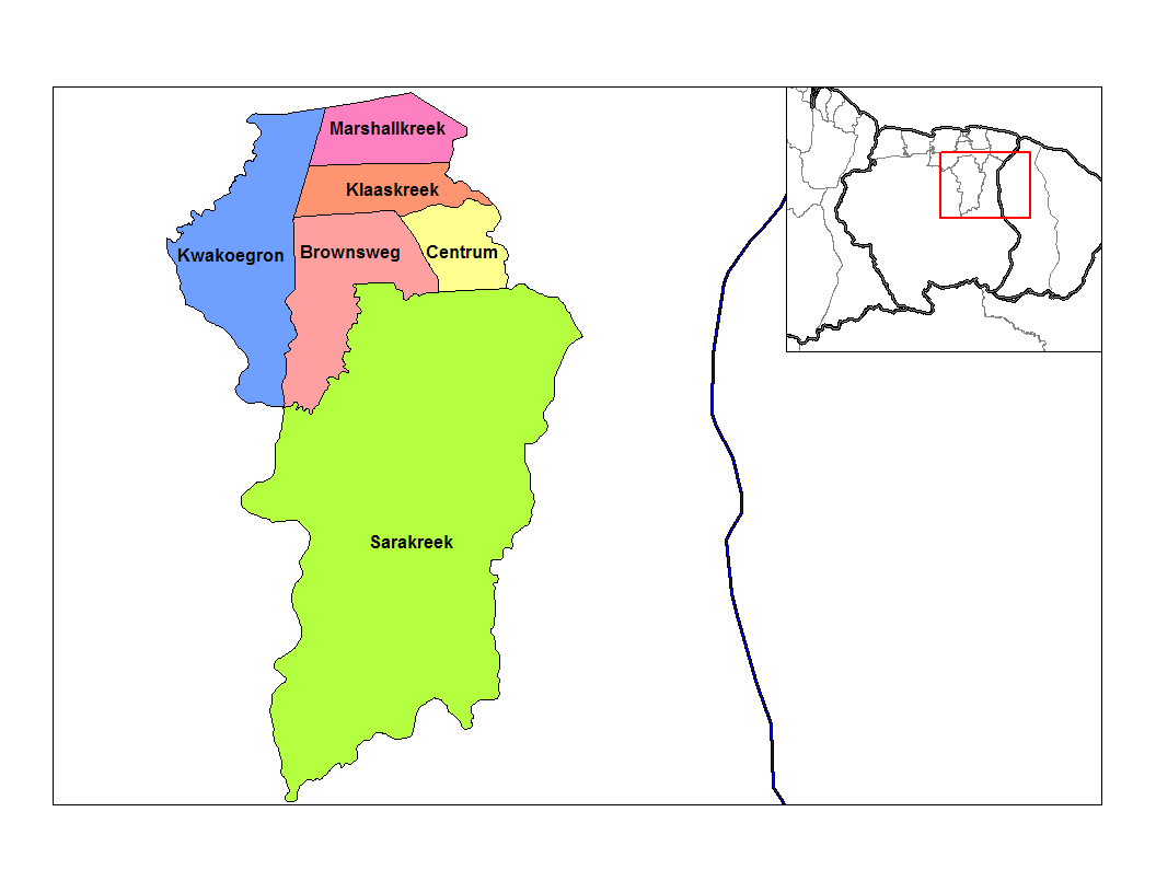
Kwakoegron (land of Kwakoe) is a town and resort in Suriname. It is located inland, due south of Paramaribo. According to the 2012 census it has a population of 263, and is mainly inhabited by Maroons, of the Matawai people. The resort and town are named after Kwakoe, the native word for Wednesday, and grond, the Dutch word for ground. The captain of the resort resides in the village Commisariskondre. Overview Kwakoegron has a school, a clinic, and a holiday resort. The resort can be accessed via a paved side road of the Southern East-West Link In 1910, Kwakoegron was connected to the Lawa Railway which closed in 1987. The Brinckheuvel Nature Reserve is located near the village. See also * Akan names The Akan people of Ghana frequently name their children after the day of the week they were born and the order in which they were born. These "day names" have further meanings concerning the soul and character of the person. Middle names have cons ... References External links ... [...More Info...] [...Related Items...] OR: [Wikipedia] [Google] [Baidu] |
Matawai People
The Matawai (also ''Matuariërs'') are a tribe of Surinamese Maroons. The Matawai were originally part of the Saramaka, and signed a peace agreement with the Dutch colonists in 1762. The tribe split from the Saramaka, and in 1769, they were recognized as a separate tribe. History The origin of the Matawai people is unclear, but oral accounts often mention the plantations Hamburg and Uitkijk. The plantations at the Jodensavanne are a possible source as well. During the 18th century, slaves escaped from the plantations and settled in the interior. According to oral accounts, a group of escaped slaves settled near the Tafelberg in the 1730s. In 1762, a full century before the general emancipation of slaves in Suriname, a group known as the Saramaka signed a peace treaty with the Dutch colonists to acknowledge their territorial rights and trading privileges. After the death of captain Abini, the relationships within the tribe became tense which ultimately resulted in captains Beku an ... [...More Info...] [...Related Items...] OR: [Wikipedia] [Google] [Baidu] |
Brokopondo District
Brokopondo is a district of Suriname. Its capital city is Brokopondo; other towns include Brownsweg and Kwakoegron. The district has a population of 15,909, and an area of 7,364 square kilometres. History The Brokopondo district was established in 1958 out of the former Suriname District. The establishment of the district was related to the 1958 Brokopondo Agreement between the Government of Suriname and Alcoa for the creation of the Brokopondo Reservoir. The Brokopondo Reservoir is a large reservoir near Afobaka which was built between 1961 and 1964, and produces hydroelectric power that provides approximately half of the domestic electrical need. The plan was very controversial, and involved transmigrating many villages that were located in the area and flooded after the construction of the Afobaka Dam. The transmigration concerned 5,000 people which were almost exclusively Maroons. In 1960, the Afobakaweg was constructed to link the reservoir with Paramaribo and the rest o ... [...More Info...] [...Related Items...] OR: [Wikipedia] [Google] [Baidu] |
Brinckheuvel Nature Reserve
The Brinckheuvel Nature Reserve (Dutch: Natuurreservaat Brinckheuvel) is a protected area and nature reserve in Suriname. The reserve is located on the Saramacca River, and is the most southern savannah of the Savannah Belt. The Mindrineti River flows through the reserve. The reserve measures 6,000 hectares, and has been a protected area since 1961. Overview The main reason for protecting the area is the unique Greywacke Greywacke or graywacke (German ''grauwacke'', signifying a grey, earthy rock) is a variety of sandstone generally characterized by its hardness, dark color, and poorly sorted angular grains of quartz, feldspar, and small rock fragments or lit ... landscape of the Sabanpasi type. The reserve contains three hills which are topped with white sand caps: the Brinckheuvel, the Klaiberheuvel and the Loblesheuvel. More than 500 plants species have been collected of which 8 are rare. Animal life has not been well studied, and data is limited to fish. One species of ... [...More Info...] [...Related Items...] OR: [Wikipedia] [Google] [Baidu] |
Lawa Railway
The Lawa Railway (Dutch language, Dutch: ''Lawaspoorweg'' or later ''Landsspoorweg'') was a single-track metre gauge railway in Suriname. It was built during the gold rush in the early 20th century, from the harbour town Paramaribo to Dam at the Sara Creek (river), Sara Creek, but it was not extended to the gold fields at the Lawa River (South America), Lawa River, as originally intended. History Private businessmen came up with the first plans, and the Governor of Suriname Cornelis Lely announced in 1902 that the government would build the railway to ease the exploitation of the gold fields. The track was intended to be more than long, but was built only halfway since the gold fields were not as efficient as hoped for.Armand SnijdersDe flop van Lely.Parbode, Surinames Magazine, 1 April 2008. In 1903 former seamen from Curacao began building the track from Paramaribo to ; this section opened in 1905. They completed the section to Dam at the Sara Creek in 1912. The rail trac ... [...More Info...] [...Related Items...] OR: [Wikipedia] [Google] [Baidu] |
Districts Of Suriname
Suriname is divided into 10 districts ( nl, districten). Overview History The country was first divided up into subdivisions by the Netherlands, Dutch on October 8, 1834, when a Royal Decree declared that there were to be 8 divisions and 2 districts: *Upper Suriname and Torarica *Para *Upper Commewijne *Upper Cottica and Perica *Lower Commewijne *Lower Cottica *Matapica *Saramacca *Coronie (district) *Nickerie (district) The divisions were areas near the capital city, Paramaribo, and the districts were areas further away from the city. In 1927, Suriname's districts were revised, and the country was divided into 7 districts. In 1943, 1948, 1949, 1952 and 1959 further small modifications were made. On October 28, 1966, the districts were redrawn again, into *Nickerie *Coronie *Saramacca *Brokopondo *Para *Suriname *Paramaribo *Commewijne *Marowijne These divisions remained until 1980, when yet again, the borders of the districts were redrawn, however, with the following requir ... [...More Info...] [...Related Items...] OR: [Wikipedia] [Google] [Baidu] |
Köppen Climate Classification
The Köppen climate classification is one of the most widely used climate classification systems. It was first published by German-Russian climatologist Wladimir Köppen (1846–1940) in 1884, with several later modifications by Köppen, notably in 1918 and 1936. Later, the climatologist Rudolf Geiger (1894–1981) introduced some changes to the classification system, which is thus sometimes called the Köppen–Geiger climate classification system. The Köppen climate classification divides climates into five main climate groups, with each group being divided based on seasonal precipitation and temperature patterns. The five main groups are ''A'' (tropical), ''B'' (arid), ''C'' (temperate), ''D'' (continental), and ''E'' (polar). Each group and subgroup is represented by a letter. All climates are assigned a main group (the first letter). All climates except for those in the ''E'' group are assigned a seasonal precipitation subgroup (the second letter). For example, ''Af'' indi ... [...More Info...] [...Related Items...] OR: [Wikipedia] [Google] [Baidu] |
Suriname
Suriname (; srn, Sranankondre or ), officially the Republic of Suriname ( nl, Republiek Suriname , srn, Ripolik fu Sranan), is a country on the northeastern Atlantic coast of South America. It is bordered by the Atlantic Ocean to the north, French Guiana to the east, Guyana to the west, and Brazil to the south. At just under , it is the smallest sovereign state in South America. It has a population of approximately , dominated by descendants from the slaves and labourers brought in from Africa and Asia by the Dutch Empire and Republic. Most of the people live by the country's (north) coast, in and around its capital and largest city, Paramaribo. It is also List of countries and dependencies by population density, one of the least densely populated countries on Earth. Situated slightly north of the equator, Suriname is a tropical country dominated by rainforests. Its extensive tree cover is vital to the country's efforts to Climate change in Suriname, mitigate climate ch ... [...More Info...] [...Related Items...] OR: [Wikipedia] [Google] [Baidu] |
Paramaribo
Paramaribo (; ; nicknamed Par'bo) is the capital and largest city of Suriname, located on the banks of the Suriname River in the Paramaribo District. Paramaribo has a population of roughly 241,000 people (2012 census), almost half of Suriname's population. The historic inner city of Paramaribo has been a UNESCO World Heritage Site since 2002. Name The city is named for the Paramaribo tribe living at the mouth of the Suriname River; the name is from Tupi–Guarani ''para'' "large river" + ''maribo'' "inhabitants". History The name Paramaribo is probably a corruption of the name of an Indian village, spelled Parmurbo in the earliest Dutch sources. This was the location of the first Dutch settlement, a trading post established by Nicolaes Baliestel and Dirck Claeszoon van Sanen in 1613. English and French traders also tried to establish settlements in Suriname, including a French post established in 1644 near present-day Paramaribo. All earlier settlements were abandoned s ... [...More Info...] [...Related Items...] OR: [Wikipedia] [Google] [Baidu] |
Maroon (people)
Maroons are descendants of Africans in the Americas who escaped from slavery and formed their own settlements. They often mixed with indigenous peoples, eventually evolving into separate creole cultures such as the Garifuna and the Mascogos. Etymology ''Maroon'', which can have a more general sense of being abandoned without resources, entered English around the 1590s, from the French adjective , meaning 'feral' or 'fugitive'. (Despite the same spelling, the meaning of 'reddish brown' for ''maroon'' did not appear until the late 1700s, perhaps influenced by the idea of maroon peoples.) The American Spanish word is also often given as the source of the English word ''maroon'', used to describe the runaway slave communities in Florida, in the Great Dismal Swamp on the border of Virginia and North Carolina, on colonial islands of the Caribbean, and in other parts of the New World. Linguist Lyle Campbell says the Spanish word ' means 'wild, unruly' or 'runaway slave'. In ... [...More Info...] [...Related Items...] OR: [Wikipedia] [Google] [Baidu] |
Digital Library For Dutch Literature
The Digital Library for Dutch Literature (Dutch: Digitale Bibliotheek voor de Nederlandse Letteren or DBNL) is a website (showing the abbreviation as dbnl) about Dutch language and Dutch literature. It contains thousands of literary texts, secondary literature and additional information, like biographies, portrayals etcetera, and hyperlinks. The DBNL is an initiative by the DBNL foundation that was founded in 1999 by the Society of Dutch Literature (Dutch: Maatschappij der Nederlandse Letterkunde). Building of the DNBL was made possible by donations, among others, from the Dutch Organization for Scientific Research (Dutch: Nederlandse Organisatie voor Wetenschappelijk Onderzoek or NWO) and the Nederlandse Taalunie. From 2008 to 2012, the editor was René van Stipriaan. The work is done by eight people in Leiden (as of 2013: The Hague), 20 students, and 50 people in the Philippines who scan and type the texts. As of 2020, the library is being maintained by a collaboration of t ... [...More Info...] [...Related Items...] OR: [Wikipedia] [Google] [Baidu] |
East-West Link (Suriname)
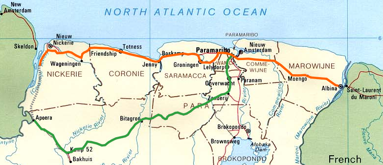
The (northern) East-West Link (Dutch: ''Oost-Westverbinding'') is a road in Suriname between Albina in the eastern part of the country to Nieuw Nickerie in the western part, via the capital city of Paramaribo. The southern East-West Link connects Paramaribo with Apoera via Bitagron. Construction of the road link started in the 1960s. Overview Bridges In recent years, various ferries on the East-West Link route have been replaced with bridges. There is a bridge near Groot Henar spanning the Nickerie River. In 1980, a bridge was built on the Commewijne River near Stolkertsijver. Since 1999, the Coppename Bridge connects Jenny with Boskamp, and since 2000 the Jules Wijdenbosch Bridge connects Paramaribo with Meerzorg. On the southern East-West Link, bailey bridges spanning the Coppename River and Nickerie River were built near Bitagron and Kamp 52 respectively. The bridge spanning the Saramacca River between Hamburg and Uitkijk was opened on 25 June 2011. Reconstruction The ... [...More Info...] [...Related Items...] OR: [Wikipedia] [Google] [Baidu] |
Akan Names
The Akan people of Ghana frequently name their children after the day of the week they were born and the order in which they were born. These "day names" have further meanings concerning the soul and character of the person. Middle names have considerably more variety and can refer to their birth order, twin status, or an ancestor's middle name. This naming tradition is shared throughout West Africa and the African diaspora. During the 18th–19th centuries, enslaved people in the Caribbean from the region that is modern-day Ghana were referred to as Coromantees. Many of the leaders of enslaved people's rebellions had "day names" including Cuffy, Cuffee or Kofi, Cudjoe or Kojo, Quao or Quaw, and Quamina or Kwame/Kwamina. Most Ghanaians have at least one name from this system, even if they also have an English or Christian name. Notable figures with day names include Ghana's first president Kwame Nkrumah and former United Nations Secretary-General Kofi Annan. In the official ort ... [...More Info...] [...Related Items...] OR: [Wikipedia] [Google] [Baidu] |


