|
Karasahr
Karasahr or Karashar ( ug, قاراشەھەر, Qarasheher, 6=Қарашәһәр), which was originally known, in the Tocharian languages as ''Ārśi'' (or Arshi) and Agni or the Chinese derivative Yanqi ( zh, s=焉耆, p=Yānqí, w=Yen-ch'i), is an ancient town on the Silk Road and the capital of Yanqi Hui Autonomous County in the Bayingolin Mongol Autonomous Prefecture, Xinjiang. it had a population of 29,000,www.xzqh.org growing to 31,773 persons in 2006; 16,032 persons of which were Han, 7781 people Hui, 7154 people Uyghur, 628 [...More Info...] [...Related Items...] OR: [Wikipedia] [Google] [Baidu] |
Tarim Basin
The Tarim Basin is an endorheic basin in Northwest China occupying an area of about and one of the largest basins in Northwest China.Chen, Yaning, et al. "Regional climate change and its effects on river runoff in the Tarim Basin, China." Hydrological Processes 20.10 (2006): 2207–2216.online 426 KB) Located in China's Xinjiang region, it is sometimes used synonymously to refer to the southern half of the province, or Nanjiang (), as opposed to the northern half of the province known as Dzungaria or Beijiang. Its northern boundary is the Tian Shan mountain range and its southern boundary is the Kunlun Mountains on the edge of the Tibetan Plateau. The Taklamakan Desert dominates much of the basin. The historical Uyghur name for the Tarim Basin is Altishahr ( Traditional spelling: 六城 or ), which means 'six cities' in Uyghur. Geography and relation to Xinjiang Xinjiang consists of two main geographically, historically, and ethnically distinct regions with different h ... [...More Info...] [...Related Items...] OR: [Wikipedia] [Google] [Baidu] |
Xinjiang
Xinjiang, SASM/GNC: ''Xinjang''; zh, c=, p=Xīnjiāng; formerly romanized as Sinkiang (, ), officially the Xinjiang Uygur Autonomous Region (XUAR), is an autonomous region of the People's Republic of China (PRC), located in the northwest of the country at the crossroads of Central Asia and East Asia. Being the largest province-level division of China by area and the 8th-largest country subdivision in the world, Xinjiang spans over and has about 25 million inhabitants. Xinjiang borders the countries of Mongolia, Russia, Kazakhstan, Kyrgyzstan, Tajikistan, Afghanistan, Pakistan and India. The rugged Karakoram, Kunlun and Tian Shan mountain ranges occupy much of Xinjiang's borders, as well as its western and southern regions. The Aksai Chin and Trans-Karakoram Tract regions, both administered by China, are claimed by India. Xinjiang also borders the Tibet Autonomous Region and the provinces of Gansu and Qinghai. The most well-known route of the historic Silk Road ... [...More Info...] [...Related Items...] OR: [Wikipedia] [Google] [Baidu] |
Yanqi Hui Autonomous County
Yanqi Hui Autonomous County (Uyghur: Qarasheher, Karashahr) is an autonomous county in the Xinjiang Uyghur Autonomous Region and is under the administration of the Bayin'gholin Mongol Autonomous Prefecture. It has an area of . According to the 2002 census, it has a population of 120,000. The Qigexing Buddhist Temple Ruins are located in Yanqi County, about southwest of the town of Yanqi. Administrative division The autonomous county contains four towns and four townships: Towns: *Yanqi Town ( / قاراشەھەر بازىرى), consisting of ten residential communities () and one village, seat of the county government, 29.000 inhabitants (2000); *Qigxin ( / شىگشىن بازىرى), one residential community and nine villages, 12.629 inhabitants (2000); *Yongning ( / يۇڭنىڭ بازىرى), two residential communities and eight villages, 18.235 inhabitants (2000); * Sishilichengzi ( / دەنزىل بازىرى), one residential community and five villages, 8.722 inhabita ... [...More Info...] [...Related Items...] OR: [Wikipedia] [Google] [Baidu] |
Tocharian Languages
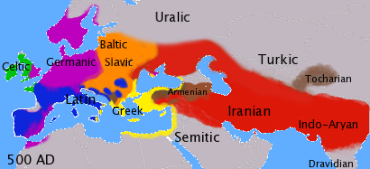
The Tocharian (sometimes ''Tokharian'') languages ( or ), also known as ''Arśi-Kuči'', Agnean-Kuchean or Kuchean-Agnean, are an extinct branch of the Indo-European language family spoken by inhabitants of the Tarim Basin, the Tocharians. The languages are known from manuscripts dating from the 5th to the 8th century AD, which were found in oasis cities on the northern edge of the Tarim Basin (now part of Xinjiang in Northwest China) and the Lop Desert. The discovery of these languages in the early 20th century contradicted the formerly prevalent idea of an east–west division of the Indo-European language family as centum and satem languages, and prompted reinvigorated study of the Indo-European family. Scholars studying these manuscripts in the early 20th century identified their authors with the ''Tokharoi'', a name used in ancient sources for people of Bactria ( Tokharistan). Although this identification is now believed to be mistaken, "Tocharian" remains the usual te ... [...More Info...] [...Related Items...] OR: [Wikipedia] [Google] [Baidu] |
Kaidu River
The Kaidu River (; Uyghur: قايدۇ دەرياسى ;), also known under its ancient name Chaidu-gol, is a river in the Xinjiang Uyghur Autonomous Region of China and an important source of water for the region. The Kaidu River is responsible for many substantial effects on the environment. Affecting the land and its people in many different ways. The sources of the Kaidu River are located on the central southern slopes of the Tian Shan from where it flows through the Yulduz Basin"Xinjiang River Guide" and the Yanqi Basin into for which it is the most important tributary. [...More Info...] [...Related Items...] OR: [Wikipedia] [Google] [Baidu] |
Tocharian A
The Tocharian (sometimes ''Tokharian'') languages ( or ), also known as ''Arśi-Kuči'', Agnean-Kuchean or Kuchean-Agnean, are an extinct branch of the Indo-European language family spoken by inhabitants of the Tarim Basin, the Tocharians. The languages are known from manuscripts dating from the 5th to the 8th century AD, which were found in oasis cities on the northern edge of the Tarim Basin (now part of Xinjiang in Northwest China) and the Lop Desert. The discovery of these languages in the early 20th century contradicted the formerly prevalent idea of an east–west division of the Indo-European language family as centum and satem languages, and prompted reinvigorated study of the Indo-European family. Scholars studying these manuscripts in the early 20th century identified their authors with the ''Tokharoi'', a name used in ancient sources for people of Bactria (Tokharistan). Although this identification is now believed to be mistaken, "Tocharian" remains the usual term for ... [...More Info...] [...Related Items...] OR: [Wikipedia] [Google] [Baidu] |
Lake Bosten
Bosten Lake (, Uyghur: / / ''Baghrash Köli / Baƣrax Kɵli'', Chagatai: ''Bostang'') is a freshwater lake on the northeastern rim of the Tarim Basin, about east of Yanqi and northeast of Korla, Xinjiang, China in the Bayin'gholin Mongol Autonomous Prefecture. Covering an area of about (together with adjacent small lakes), it is the largest lake in Xinjiang and one of the largest inland freshwater lakes in China. Bosten lake receives water inflow from a catchment area of . The lake's Uyghur and Chinese names are sometimes rendered as ''Bosten Hu'', ''Bagrax-hu'', ''Bagrasch-köl'', ''Baghrasch köl'', ''Bagratsch-kul'', ''Bositeng Lake'' or ''Bositeng Hu.'' The Kaidu River is the most important tributary to Lake Bosten, accounting for about 83% of its water inflow, other significant tributaries are the Huangshui Ditch (), the Qingshui River (), and Wulasite River (). An active fishery exists on the lake. Until the early 1970s, two cyprinid species, ''Schizothorax bid ... [...More Info...] [...Related Items...] OR: [Wikipedia] [Google] [Baidu] |
Uyghurs
The Uyghurs; ; ; ; zh, s=, t=, p=Wéiwú'ěr, IPA: ( ), alternatively spelled Uighurs, Uygurs or Uigurs, are a Turkic ethnic group originating from and culturally affiliated with the general region of Central and East Asia. The Uyghurs are recognized as native to the Xinjiang Uyghur Autonomous Region in Northwest China. They are one of China's 55 officially recognized ethnic minorities. The Uyghurs are recognized by the Chinese government as a regional minority and the titular people of Xinjiang. The Uyghurs have traditionally inhabited a series of oases scattered across the Taklamakan Desert within the Tarim Basin. These oases have historically existed as independent states or were controlled by many civilizations including China, the Mongols, the Tibetans and various Turkic polities. The Uyghurs gradually started to become Islamized in the 10th century and most Uyghurs identified as Muslims by the 16th century. Islam has since played an important role in U ... [...More Info...] [...Related Items...] OR: [Wikipedia] [Google] [Baidu] |
Silk Route
The Silk Road () was a network of Eurasian trade routes active from the second century BCE until the mid-15th century. Spanning over 6,400 kilometers (4,000 miles), it played a central role in facilitating economic, cultural, political, and religious interactions between the East and West. The name "Silk Road", first coined in the late 19th century, has fallen into disuse among some modern historians in favor of Silk Routes, on the grounds that it more accurately describes the intricate web of land and sea routes connecting East and Southeast Asia, the Indian subcontinent, Central Asia, the Middle East, East Africa and Europe. The Silk Road derives its name from the highly lucrative trade of silk textiles that were produced almost exclusively in China. The network began with the Han dynasty's expansion into Central Asia around 114 BCE, which largely pacified the once untamed region. Imperial envoy Zhang Qian was commissioned to explore the unknown lands beyond the region i ... [...More Info...] [...Related Items...] OR: [Wikipedia] [Google] [Baidu] |
Indo-European Migrations
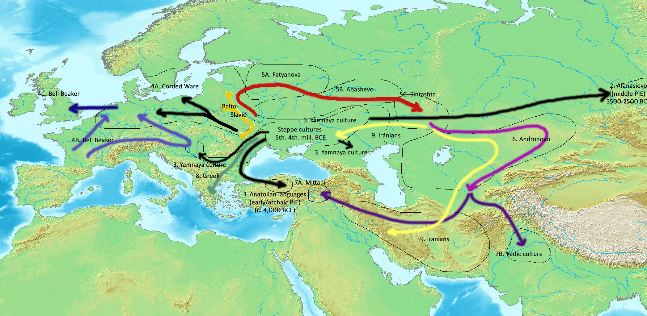
The Indo-European migrations were hypothesized migrations of Proto-Indo-European language (PIE) speakers, and subsequent migrations of people speaking derived Indo-European languages, which took place approx. 4000 to 1000 BCE, potentially explaining how these languages came to be spoken across a large area of Eurasia, from India and Iran, to Europe. While there can be no direct evidence of prehistoric languages, a synthesis of linguistics, archaeology, anthropology and genetics establish both the existence of Proto-Indo-European and the spread of its daughter dialects through migrations of large populations of its speakers, as well as the recruitment of new speakers through emulation of conquering elites. Comparative linguistics describes the similarities between various languages and the laws of systematic change, which allow the reconstruction of ancestral speech (see Indo-European studies). Archaeology traces the spread of artifacts, habitations, and burial sites pr ... [...More Info...] [...Related Items...] OR: [Wikipedia] [Google] [Baidu] |
Tokharistan
Tokharistan (formed from "Tokhara" and the suffix ''-stan'' meaning "place of" in Persian) is an ancient Early Middle Ages name given to the area which was known as Bactria in Ancient Greek sources. In the 7th and 8th century CE, Tokharistan came under the rule of the Chinese Empire, administered by the Protectorate General to Pacify the West. Today, Tokharistan is fragmented between Uzbekistan, Tajikistan and Afghanistan. Names of Tokharistan Several languages have used variations of the word "Tokhara" to designate the region: * Tokharistan may appear in ancient India sources as the Kingdom of Tushara, to the northwest of India. "Tushara" is the Sanskrit word for "snowy" "frigid", and is known to have been used to designate the country of Tukhara. In Sanskrit, it became तुखार (Tukhāra). * In ancient Greek, the name was Tokharoi ( grc, Τόχαροι ) or Thaguroi. * Tochari for Latin historians. * The name "Tokhara" appeared in the 4th century CE, in Buddhist te ... [...More Info...] [...Related Items...] OR: [Wikipedia] [Google] [Baidu] |
Korla
Korla,The official spelling according to also known as Kurla, National Geospatial-Intelligence Agency, United States National Geospatial-Intelligence Agency or from Mandarin Chinese as Ku'erle or Kuerle, is the second largest city in Xinjiang. It is a county-level city and the seat of the Bayingolin Mongol Autonomous Prefecture, the largest prefecture of China. Korla has existed since at least the Han Dynasty. Korla is known for its production of fragrant pears and is a production center for the Tarim oil fields. History Han Dynasty Korla was known as Yuli () (reconstructed pronunciation of first character: *i̯wəd) during the Han Dynasty. Yuli is said in the Hanshu or 'History of the Former Han' (covering the period 125 BCE to 23 CE), to have had 1,200 households, 9,600 individuals and 2,000 people able to bear arms. It also mentions that it adjoined Shanshan and Qiemo (Charchan) to the south. In 61 CE, the Xiongnu led some 30,000 troops from 15 kingdoms including Korla, Ka ... [...More Info...] [...Related Items...] OR: [Wikipedia] [Google] [Baidu] |


.png)
