|
Jacobstow
Jacobstow ( kw, Lannjago) is a civil parish and village in north Cornwall, England, United Kingdom. The village is located east of the A39 road approximately seven miles (11 km) south of Bude.Ordnance Survey: Landranger map sheet 190 ''Bude & Clovelly'' Penhallym in the north of the parish is mentioned (as ''Penhalun'') in the Domesday Book;GENUKI website; Jacobstow Retrieved May 2010 nearby is , site of a medieval manor. The name Jacobstow originates from Saxon times and derives from ''St James'' (Latin ''Jacobus'') and ''holy place''. As well as the church town, oth ... [...More Info...] [...Related Items...] OR: [Wikipedia] [Google] [Baidu] |
St James' Church, Jacobstow
St James’ Church, Jacobstow is a Grade I listed parish church in the Church of England in Jacobstow, Cornwall. History The earliest records date from the 13th century. On the day after Trinity Sunday, 1270, the Bishop admitted to the rectory Richard de Cetrefort, sub-deacon; patron, Sir Henry de Campo Armilfii (Champernowne). In the taxation of Pope Nicholas IV the church of Jacobstow was taxed at £6. About 1297, William, then chaplain of Jacobstow was one of the priests incarcerated in the Royal prison at Launceston Castle, on account of their refusal to surrender half their income to the Royal expenditure. The church dates from the 15th century and replaces an earlier building. The chancel was rebuilt and the nave roof replaced at a cost of £700 in 1886 by architect Otho Bathurst Peter of Launceston. The windows were repaired and reglazed. The church was reseated. The aisle roofs were reslated and releaded, the stonework was cleaned down and repointed. The east and south c ... [...More Info...] [...Related Items...] OR: [Wikipedia] [Google] [Baidu] |
Southcott, Cornwall
Southcott ( kw, Sothdyji) is a hamlet southwest of Jacobstow in north Cornwall, United Kingdom.''Philip's Street Atlas Cornwall''. London: Philip's, 2003; p. 11 It consists of ''Higher'', ''Middle'' and ''Lower'' ''Southcott''. ''Higher Southcott'' now completely borders Jacobstow and ''Lower Southcott'' borders another small hamlet named ''Kent''. At the 2011 census population details were included in the civil parish of Jacobstow Jacobstow ( kw, Lannjago) is a civil parish and village in north Cornwall, England, United Kingdom. The village is located east of the A39 road approximately seven miles (11 km) south of Bude.Ordnance Survey: Landranger map sheet 190 ''Bude .... References External links Hamlets in Cornwall {{Cornwall-geo-stub ... [...More Info...] [...Related Items...] OR: [Wikipedia] [Google] [Baidu] |
Penhallam
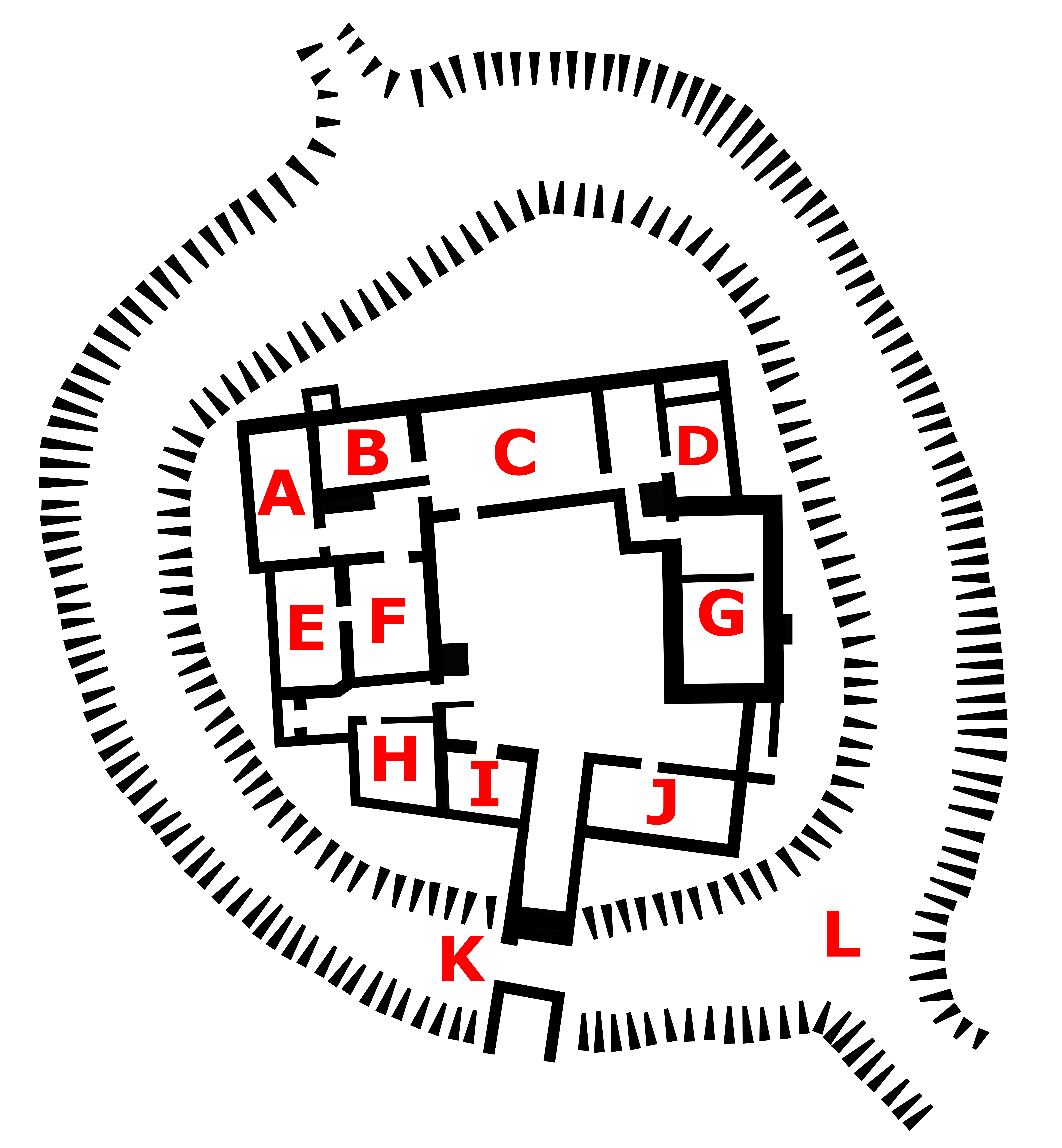
Penhallam is the site of a fortified manor house near Jacobstow in Cornwall, England. There was probably an earlier, 11th-century ringwork castle on the site, constructed by Tryold or his son, Richard fitz Turold in the years after the Norman invasion of 1066. Their descendants, in particular Andrew de Cardinham, created a substantial, sophisticated manor house at Penhallam between the 1180s and 1234, building a quadrangle of ranges facing onto an internal courtyard, surrounded by a moat and external buildings. The Cardinhams may have used the manor house for hunting expeditions in their nearby deer park. By the 14th century, the Cardinham male line had died out and the house was occupied by tenants. The surrounding manor was broken up and the house itself fell into decay and robbed for its stone. Archaeological investigations between 1968 and 1973 uncovered its foundations, unaltered since the medieval period, and the site is now managed by English Heritage and open to visit ... [...More Info...] [...Related Items...] OR: [Wikipedia] [Google] [Baidu] |
Civil Parishes In Cornwall
A civil parishes in England, civil parish is a country subdivision, forming the lowest unit of local government in England, local government in England. There are 218 civil parishes in the ceremonial county of Cornwall, which includes the Isles of Scilly. The county is effectively parished in its entirety; only the unpopulated Wolf Rock, Cornwall, Wolf Rock is unparished. At the United Kingdom Census 2001, 2001 census, there were 501,267 people living in the current parishes, accounting for the whole of the county's population. The final unparished areas of mainland Cornwall, around St Austell, were parished on 1 April 2009 to coincide with the 2009 structural changes to local government in England, structural changes to local government in England. Population sizes within the county vary considerably, Falmouth, Cornwall, Falmouth is the most populous with a population of 26,767, recorded in 2011, and St Michael's Mount the least with 29 residents. The county is governed by two ... [...More Info...] [...Related Items...] OR: [Wikipedia] [Google] [Baidu] |
Degory Wheare
Degory Wheare, also spelt Digory Whear (the first name can be Latinized as Degoreus or Digoreus) (1573 – 1 August 1647) was an historian, the first Camden Professor of Ancient History in the University of Oxford. Life He was born in Jacobstow, Cornwall, at the mansion of Berry Court. He matriculated at Broadgates Hall, Oxford, on 6 July 1593, graduated B.A. on 5 February 1597, and proceeded M.A. on 16 June 1600. He was a contemporary of Francis Rous, a lifelong friend; and he was tutor at Broadgates Hall to John Pym (matriculated 18 May 1599). Another Oxford friend was Charles Fitzgeoffrey. Wheare was admitted on 7 July 1602 as Cornish fellow of Exeter College, Oxford, and became full fellow on 7 July 1603. He was headmaster of Abingdon School from 1605–1606. He resigned his fellowship on 30 April 1608. In that year he went abroad as travelling companion to Grey Brydges, 5th Baron Chandos; and on his return to England Wheare continued to live with him. He was then perm ... [...More Info...] [...Related Items...] OR: [Wikipedia] [Google] [Baidu] |
Canworthy Water
Canworthy Water ( kw, Boskarn) is a settlement in northeast Cornwall, England, United Kingdom. It is situated beside the River Ottery at approximately seven miles (11 km) northeast of Camelford.Ordnance Survey: Landranger map sheet 190 ''Bude & Clovelly'' Canworthy Water is mainly in the civil parish of Warbstow (Detached), with parts north of the River Ottery in Jacobstow Jacobstow ( kw, Lannjago) is a civil parish and village in north Cornwall, England, United Kingdom. The village is located east of the A39 road approximately seven miles (11 km) south of Bude.Ordnance Survey: Landranger map sheet 190 ''Bude ... civil parish. The original village of Canworthy ( kw, Esk) is north of the river Ottery and the more modern, and subsequently larger village, Canworthy Water ( kw, Dowr Karn) is located on the river. References Villages in Cornwall {{Cornwall-geo-stub ... [...More Info...] [...Related Items...] OR: [Wikipedia] [Google] [Baidu] |
Poundstock
Poundstock ( kw, Tregorlann) is a civil parish and a hamlet on the north coast of Cornwall, England, United Kingdom. The hamlet is situated four miles (6.5 km) south of Bude half-a-mile west of the A39 trunk road about one mile from the coast. Poundstock civil parish is in the Registration District of Stratton. It is bounded to the west by the Atlantic Ocean; to the north by Marhamchurch parish, to the east by Week St Mary parish, and to the south by the parishes of Jacobstow and St Gennys. The population of the parish in the 2001 census was 805, increasing to 925 at the 2011 census. An electoral ward bearing the same name also exists with a population at the same census of 3,846. The manor of Poundstock was recorded in the Domesday Book (1086) when it was held by Jovin from Robert, Count of Mortain. Before 1066 it had been held by Gytha who paid tax for one virgate of land but there was one hide of land and land for 6 ploughs. There were 2 ploughs, 1 serf, 1 villein, 3 s ... [...More Info...] [...Related Items...] OR: [Wikipedia] [Google] [Baidu] |
St Gennys
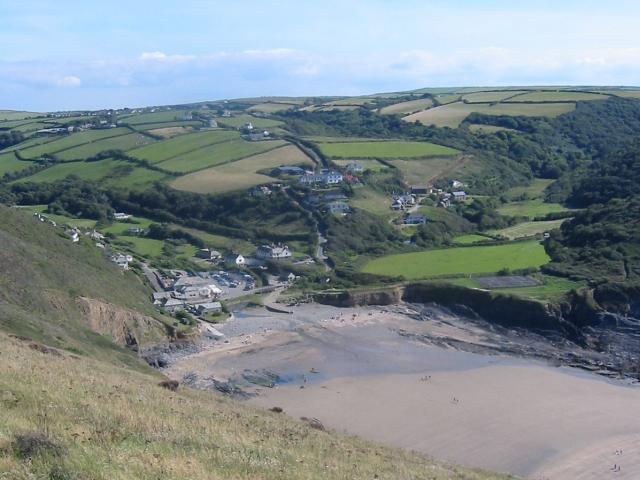
St Gennys ( kw, S. Gwynnas) is a coastal civil parish and small settlement in north Cornwall, England, United Kingdom. The hamlet of St Gennys is about seven miles (11.3 km) southwest of Bude.Ordnance Survey: Landranger map sheet 190 ''Bude & Clovelly'' It is on high ground half-a-mile north of the coastal village of Crackington Haven, the major settlement in the parish. The only other settlements of any size in the parish are Middle Crackington and Higher Crackington both of which are southeast of Crackington Haven, half-a-mile and one mile distant respectively. The population of the parish at the 2011 census was 873. History and geography The name St Gennys is generally thought to derive from 4th Century Christian martyr Saint Genesius although it has been suggested that the commemoration is to the Welsh Saint Gwynws. In either case the name is old and several places in the parish are mentioned in the Domesday Book including Crackington (as ''Crachemua''), Dizzard (a ... [...More Info...] [...Related Items...] OR: [Wikipedia] [Google] [Baidu] |
University Of Oxford
, mottoeng = The Lord is my light , established = , endowment = £6.1 billion (including colleges) (2019) , budget = £2.145 billion (2019–20) , chancellor = The Lord Patten of Barnes , vice_chancellor = Louise Richardson , students = 24,515 (2019) , undergrad = 11,955 , postgrad = 12,010 , other = 541 (2017) , city = Oxford , country = England , coordinates = , campus_type = University town , athletics_affiliations = Blue (university sport) , logo_size = 250px , website = , logo = University of Oxford.svg , colours = Oxford Blue , faculty = 6,995 (2020) , academic_affiliations = , The University of Oxford is a collegiate research university in Oxf ... [...More Info...] [...Related Items...] OR: [Wikipedia] [Google] [Baidu] |
Camden Professor Of Ancient History
The Camden Professorship of Ancient History at the University of Oxford was established in 1622 by English antiquary and historian William Camden, Clarenceux King of Arms, and endowed with the income of the manor of Bexley, becoming the first and oldest chair of history in England. Since 1877 it has been attached to Brasenose College, and since 1910 it has been limited to Roman history. List of Camden Professors of Ancient History List of holders of the chair since its foundation: # Degory Wheare 1622–1647 # Robert Waryng 1647–1648 # Lewis du Moulin 1648–1660 # John Lamphire 1660–1688 # Henry Dodwell 1688–1691 # Charles Aldworth 1691–1720 # Sedgwick Harrison 1720–1727 # Richard Frewin 1727–1761 # John Warneford 1761–1773 # William Scott (later Lord Stowell) 1773–1785 # Thomas Warton 1785–1790 # Thomas Winstanley 1790–1823 # Peter Elmsley 1823–1825 # Edward Cardwell 1825–1861 # George Rawlinson 1861–1889 # Henry Francis Pelham 1889–1907 # Franci ... [...More Info...] [...Related Items...] OR: [Wikipedia] [Google] [Baidu] |
Eden Methodist Chapel - Geograph
Eden may refer to: *Garden of Eden, the "garden of God" described in the Book of Genesis Places and jurisdictions Canada * Eden, Ontario * Eden High School Middle East * Eden, Lebanon, a city and former bishopric * Camp Eden, Iraq Oceania * Eden (New Zealand electorate), a former New Zealand Parliamentary electorate * Eden, New South Wales, Australia ** Electoral district of Eden, an electoral district in New South Wales United Kingdom * Eden, County Antrim, a townland in Northern Ireland *Eden, the names of three townlands in County Londonderry, Northern Ireland: ** Eden, Dungiven parish ** Eden, Learmount parish (County Londonderry portion) ** Eden, Tamlaght O'Crilly parish * Eden, a townland in County Tyrone, Northern Ireland * Eden, High Wycombe, a shopping centre in Buckinghamshire, England * Eden District, Cumbria, England * Eden Project, a visitor attraction in Cornwall, England * Eden Water, a tributary of the River Tweed, Scotland * River Eden, Ken ... [...More Info...] [...Related Items...] OR: [Wikipedia] [Google] [Baidu] |


