|
Ings, Cumbria
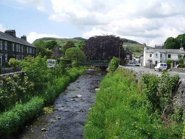
Ings is a village in the South Lakeland district of Cumbria, England. It lies on the course on the River Gowan and A591 road, east of Windermere. Ings is located in the parish of Hugill, historically a part of Westmorland. The Grade II*-listed St Anne's Church is located within the village. See also *Listed buildings in Hugill Hugill is a civil parish in the South Lakeland District of Cumbria, England. It contains nine listed buildings that are recorded in the National Heritage List for England. Of these, two are listed at Grade II*, the middle of the three gr ... References External links Cumbria County History Trust: Hugill(nb: provisional research only – see Talk page) Villages in Cumbria South Lakeland District {{Cumbria-geo-stub ... [...More Info...] [...Related Items...] OR: [Wikipedia] [Google] [Baidu] |
South Lakeland
South Lakeland is a local government district in Cumbria, England. The population of the non-metropolitan district was 102,301 according to the 2001 census, increasing to 103,658 at the 2011 Census. Its council is based in Kendal. It includes much of the Lake District as well as northwestern parts of the Yorkshire Dales. The district was created on 1 April 1974 under the Local Government Act 1972. It was formed from the Kendal borough, Windermere urban district, most of Lakes urban district, South Westmorland Rural District, from Westmorland, Grange and Ulverston urban districts and North Lonsdale Rural District from Lancashire, and Sedbergh Rural District from the West Riding of Yorkshire. In July 2021 the Ministry of Housing, Communities and Local Government announced that in April 2023, Cumbria will be reorganised into two unitary authorities. South Lakeland District Council is to be abolished and its functions transferred to a new authority, to be known as Westmorla ... [...More Info...] [...Related Items...] OR: [Wikipedia] [Google] [Baidu] |
Cumbria
Cumbria ( ) is a ceremonial and non-metropolitan county in North West England, bordering Scotland. The county and Cumbria County Council, its local government, came into existence in 1974 after the passage of the Local Government Act 1972. Cumbria's county town is Carlisle, in the north of the county. Other major settlements include Barrow-in-Furness, Kendal, Whitehaven and Workington. The administrative county of Cumbria consists of six districts ( Allerdale, Barrow-in-Furness, Carlisle, Copeland, Eden and South Lakeland) and, in 2019, had a population of 500,012. Cumbria is one of the most sparsely populated counties in England, with 73.4 people per km2 (190/sq mi). On 1 April 2023, the administrative county of Cumbria will be abolished and replaced with two new unitary authorities: Westmorland and Furness (Barrow-in-Furness, Eden, South Lakeland) and Cumberland ( Allerdale, Carlisle, Copeland). Cumbria is the third largest ceremonial county in England by area. It i ... [...More Info...] [...Related Items...] OR: [Wikipedia] [Google] [Baidu] |
Westmorland And Lonsdale (UK Parliament Constituency)
Westmorland (, formerly also spelt ''Westmoreland'';R. Wilkinson The British Isles, Sheet The British IslesVision of Britain/ref> is a historic county in North West England spanning the southern Lake District and the northern Dales. It had an administrative function from the 12th century until 1974. Between 1974 and 2023 Westmorland lay within the administrative county of Cumbria. In April 2023, Cumbria County Council will be abolished and replaced with two unitary authorities, one of which, Westmorland and Furness, will cover all of Westmorland (as well as other areas), thereby restoring the Westmorland name to a top-tier administrative entity. The people of Westmorland are known as Westmerians. Early history Background At the beginning of the 10th century a large part of modern day Cumbria was part of the Kingdom of Strathclyde, and was known as '' "Scottish Cumberland" ''. The Rere Cross was ordered by Edmund I (r.939-946) to serve as a boundary marker between England ... [...More Info...] [...Related Items...] OR: [Wikipedia] [Google] [Baidu] |
Hugill
Hugill is a civil parish in the South Lakeland district of the English county of Cumbria. Hugill includes the village of Ings and the hamlets of Grassgarth, and Reston plus a large part of the village of Staveley and the west bank of the River Kent north of Barley Bridge. It was formerly a part of the Barony of Kendal. In the 2001 census the parish had a population of 416, increasing at the 2011 census to 446. Approximately 60% of the population live in Staveley or the Kent valley. In the 1870s, Hugill was described as :''The township lies on the Kendal and Windermere railway, 2 miles E of Windermere; and contains the hamlets of Ings, Grass-Garth, and BorwickFold. Reston Scar is a prominent feature in the valley.'' Staveley with Ings Parish Council represents the three civil parishes of Hugill, Nether Staveley and Over Staveley. It has produced two ambitious Parish Plans, which have set out ''"aspirations for the future."'' that are concerned with improving the environme ... [...More Info...] [...Related Items...] OR: [Wikipedia] [Google] [Baidu] |
River Gowan, Cumbria
The River Gowan is a short river in Cumbria, running easterly through the village of Ings before joining the River Kent at Staveley. Etymology It is difficult to determine where the river got its name. In Scottish English, ''gowan'' the name for the common daisy or occasionally the buttercup. It is derived from the original form ''gollan'' which is the marsh marigold, the name was made famous by Robert Burns in a poem originally entitled ''"The Gowan"'' which is now known as ''"To a Mountain Daisy"''. The Lakeland poet William Wordsworth also uses the word gowan to refer to a common wayside flower indicating that the name was used in the area and therefore it is possible that the river got its name from the fact that it flows through many flower meadows on the valley floor. In Scottish Gaelic ''Gowen/Gowan'' can also mean "''blacksmith''". The name may therefore otherwise have come from the Scots Gaelic or from Irish missionaries who are known to have travelled in Cumbria duri ... [...More Info...] [...Related Items...] OR: [Wikipedia] [Google] [Baidu] |
A591 Road
The A591 is a major road in Cumbria, in the north-west of England, which lies almost entirely within the Lake District national park. A 2009 poll by satellite navigation firm Garmin named the stretch of the road between Windermere and Keswick as the most popular road in Britain. The 29.8 mile stretch between Kendal and Keswick was also named the UK's best driving road, according to a specially devised driving ratio formulated by car rental firm Avis. Route The road begins (at its southern end) north-west of junction 36 of the M6 motorway at Brettargh Holt roundabout with the A590 road close to Sizergh Castle. It bypasses the town of Kendal as a dual carriageway, this £1.9m section opened on 29 August 1971. It becomes a busy single carriageway road as it enters the Lake District. It bypasses the town of Windermere, closely following the north-eastern bank of Windermere. It then travels through the centre of Ambleside, follows the northern side of Rydal Water, passes White ... [...More Info...] [...Related Items...] OR: [Wikipedia] [Google] [Baidu] |
Windermere, Cumbria (town)
Windermere () is a town in the civil parish of Windermere and Bowness, in the South Lakeland District of Cumbria, England. In the 2001 census the parish had a population of 8,245, increasing at the 2011 census to 8,359. It lies about half a mile (1 km) east of the lake, Windermere. Although the town Windermere does not touch the lake (it took the name of the lake when the railway line was built in 1847 and the station was called "Windermere"), it has now grown together with the older lakeside town of Bowness-on-Windermere, though the two retain distinguishable town centres. Tourism is popular in the town owing to its proximity to the lake and local scenery. Boats from the piers in Bowness sail around the lake, many calling at Ambleside or at Lakeside where there is a restored railway. Windermere Hotel opened at the same time as the railway. The civil parish contains both towns, the village of Troutbeck Bridge to the north and several hamlets, including Storrs to the so ... [...More Info...] [...Related Items...] OR: [Wikipedia] [Google] [Baidu] |
Westmorland
Westmorland (, formerly also spelt ''Westmoreland'';R. Wilkinson The British Isles, Sheet The British IslesVision of Britain/ref> is a historic county in North West England spanning the southern Lake District and the northern Dales. It had an administrative function from the 12th century until 1974. Between 1974 and 2023 Westmorland lay within the administrative county of Cumbria. In April 2023, Cumbria County Council will be abolished and replaced with two unitary authorities, one of which, Westmorland and Furness, will cover all of Westmorland (as well as other areas), thereby restoring the Westmorland name to a top-tier administrative entity. The people of Westmorland are known as Westmerians. Early history Background At the beginning of the 10th century a large part of modern day Cumbria was part of the Kingdom of Strathclyde, and was known as '' "Scottish Cumberland" ''. The Rere Cross was ordered by Edmund I (r.939-946) to serve as a boundary marker between England an ... [...More Info...] [...Related Items...] OR: [Wikipedia] [Google] [Baidu] |
Listed Buildings In Hugill
Hugill is a civil parish in the South Lakeland District of Cumbria, England. It contains nine listed buildings that are recorded in the National Heritage List for England. Of these, two are listed at Grade II*, the middle of the three grades, and the others are at Grade II, the lowest grade. The parish is in the Lake District National Park and is almost completely rural, the only settlement being the village of Ings. Most of the listed buildings are farmhouses and farm buildings, the others being a country house An English country house is a large house or mansion in the English countryside. Such houses were often owned by individuals who also owned a town house. This allowed them to spend time in the country and in the city—hence, for these peopl ..., a monument, a church, and a school later used as a parish hall. __NOTOC__ Key Buildings References Citations Sources * * * * * * * * * * * {{DEFAULTSORT:Hugill Lists of listed buildings in Cumb ... [...More Info...] [...Related Items...] OR: [Wikipedia] [Google] [Baidu] |
Villages In Cumbria
A village is a clustered human settlement or community, larger than a hamlet but smaller than a town (although the word is often used to describe both hamlets and smaller towns), with a population typically ranging from a few hundred to a few thousand. Though villages are often located in rural areas, the term urban village is also applied to certain urban neighborhoods. Villages are normally permanent, with fixed dwellings; however, transient villages can occur. Further, the dwellings of a village are fairly close to one another, not scattered broadly over the landscape, as a dispersed settlement. In the past, villages were a usual form of community for societies that practice subsistence agriculture, and also for some non-agricultural societies. In Great Britain, a hamlet earned the right to be called a village when it built a church. [...More Info...] [...Related Items...] OR: [Wikipedia] [Google] [Baidu] |


