|
Huayco
A huaico or huayco (from the Quechua ''wayqu'', meaning "depth, valley") is an Andean term for the mudslide and flash flood caused by torrential rains occurring high in the mountains, especially during the weather phenomenon known as ''El Niño''. National forests such as the San Matías–San Carlos Protection Forest were created in Peru to protect vegetation, which reduces runoff, and prevent huaicos. The indigenous Mapuche residents of ''Lo Barnechea'', in present-day Santiago Province, Chile, were called ''Huaicoches'' in their Mapudungun language: ''Huaico'' (flash flood) and ''che'' (people). "''Cabeça d'água''" (lit. "Water head") is a term in Brazil Brazil ( pt, Brasil; ), officially the Federative Republic of Brazil (Portuguese: ), is the largest country in both South America and Latin America. At and with over 217 million people, Brazil is the world's fifth-largest country by area ... describing similar phenomena: During orographic rain, rivers in mounta ... [...More Info...] [...Related Items...] OR: [Wikipedia] [Google] [Baidu] |
Flash Flood
A flash flood is a rapid flooding of low-lying areas: washes, rivers, dry lakes and depressions. It may be caused by heavy rain associated with a severe thunderstorm, hurricane, or tropical storm, or by meltwater from ice or snow flowing over ice sheets or snowfields. Flash floods may also occur after the collapse of a natural ice or debris dam, or a human structure such as a man-made dam, as occurred before the Johnstown Flood of 1889. Flash floods are distinguished from regular floods by having a timescale of fewer than six hours between rainfall and the onset of flooding. Flash floods are a significant hazard, causing more fatalities in the U.S. in an average year than lightning, tornadoes, or hurricanes. Flash floods can also deposit large quantities of sediments on floodplains and can be destructive of vegetation cover not adapted to frequent flood conditions. Causes Flash floods most often occur in dry areas that have recently received precipitation, but they may ... [...More Info...] [...Related Items...] OR: [Wikipedia] [Google] [Baidu] |
Quechua Language
Quechua (, ; ), usually called ("people's language") in Quechuan languages, is an Indigenous languages of the Americas, indigenous language family spoken by the Quechua peoples, primarily living in the Peruvian Andes. Derived from a common ancestral language, it is the most widely spoken Pre-Columbian era, pre-Columbian language family of the Americas, with an estimated 8–10 million speakers as of 2004.Adelaar 2004, pp. 167–168, 255. Approximately 25% (7.7 million) of Peruvians speak a Quechuan language. It is perhaps most widely known for being the main language family of the Inca Empire. The Spanish encouraged its use until the Peruvian War of Independence, Peruvian struggle for independence of the 1780s. As a result, Quechua variants are still widely spoken today, being the co-official language of many regions and the second most spoken language family in Peru. History Quechua had already expanded across wide ranges of the central Andes long before the expansion of the ... [...More Info...] [...Related Items...] OR: [Wikipedia] [Google] [Baidu] |
Andes
The Andes, Andes Mountains or Andean Mountains (; ) are the longest continental mountain range in the world, forming a continuous highland along the western edge of South America. The range is long, wide (widest between 18°S – 20°S latitude), and has an average height of about . The Andes extend from north to south through seven South American countries: Venezuela, Colombia, Ecuador, Peru, Bolivia, Chile, and Argentina. Along their length, the Andes are split into several ranges, separated by intermediate depressions. The Andes are the location of several high plateaus—some of which host major cities such as Quito, Bogotá, Cali, Arequipa, Medellín, Bucaramanga, Sucre, Mérida, El Alto and La Paz. The Altiplano plateau is the world's second-highest after the Tibetan plateau. These ranges are in turn grouped into three major divisions based on climate: the Tropical Andes, the Dry Andes, and the Wet Andes. The Andes Mountains are the highest m ... [...More Info...] [...Related Items...] OR: [Wikipedia] [Google] [Baidu] |
Mudslide
A mudflow or mud flow is a form of mass wasting involving fast-moving flow of debris that has become liquified by the addition of water. Such flows can move at speeds ranging from 3 meters/minute to 5 meters/second. Mudflows contain a significant proportion of clay, which makes them more fluid than debris flows, allowing them to travel farther and across lower slope angles. Both types of flow are generally mixtures of particles with a wide range of sizes, which typically become sorted by size upon deposition. Mudflows are often called mudslides, a term applied indiscriminately by the mass media to a variety of mass wasting events. Mudflows often start as slides, becoming flows as water is entrained along the flow path; such events are often called flow slides. Other types of mudflows include lahars (involving fine-grained pyroclastic deposits on the flanks of volcanoes) and jökulhlaups (outbursts from under glaciers or icecaps). A statutory definition of "flood-related mudsli ... [...More Info...] [...Related Items...] OR: [Wikipedia] [Google] [Baidu] |
Rain
Rain is water droplets that have condensed from atmospheric water vapor and then fall under gravity. Rain is a major component of the water cycle and is responsible for depositing most of the fresh water on the Earth. It provides water for hydroelectric power plants, crop irrigation, and suitable conditions for many types of ecosystems. The major cause of rain production is moisture moving along three-dimensional zones of temperature and moisture contrasts known as weather fronts. If enough moisture and upward motion is present, precipitation falls from convective clouds (those with strong upward vertical motion) such as cumulonimbus (thunder clouds) which can organize into narrow rainbands. In mountainous areas, heavy precipitation is possible where upslope flow is maximized within windward sides of the terrain at elevation which forces moist air to condense and fall out as rainfall along the sides of mountains. On the leeward side of mountains, desert climates can exi ... [...More Info...] [...Related Items...] OR: [Wikipedia] [Google] [Baidu] |
El Niño
El Niño (; ; ) is the warm phase of the El Niño–Southern Oscillation (ENSO) and is associated with a band of warm ocean water that develops in the central and east-central equatorial Pacific (approximately between the International Date Line and 120°W), including the area off the Pacific coast of South America. The ENSO is the cycle of warm and cold sea surface temperature (SST) of the tropical central and eastern Pacific Ocean. El Niño is accompanied by high air pressure in the western Pacific and low air pressure in the eastern Pacific. El Niño phases are known to last close to four years; however, records demonstrate that the cycles have lasted between two and seven years. During the development of El Niño, rainfall develops between September–November. The cool phase of ENSO is es, La Niña, translation=The Girl, with SSTs in the eastern Pacific below average, and air pressure high in the eastern Pacific and low in the western Pacific. The ENSO cycle, including bo ... [...More Info...] [...Related Items...] OR: [Wikipedia] [Google] [Baidu] |
San Matías–San Carlos Protection Forest
The San Matías–San Carlos Protection Forest (Bosque de Protección San Matías-San Carlos) is a national forest situated in Pasco Region, Peru. It is a forest set aside to preserve the soils and to protect infrastructure, towns, and agricultural grounds against the effects of the water erosion, huaycos, streams or floods. It lies within the Peruvian Yungas and Ucayali moist forests ecoregion An ecoregion (ecological region) or ecozone (ecological zone) is an ecologically and geographically defined area that is smaller than a bioregion, which in turn is smaller than a biogeographic realm. Ecoregions cover relatively large areas of ...s. It also allows for the maintenance and development of the cultural values of the native communities, such as the Ashaninkas, and Amueshas. References See also * Natural and Cultural Peruvian Heritage National forests of Peru Geography of Pasco Region {{SouthAm-protected-area-stub ... [...More Info...] [...Related Items...] OR: [Wikipedia] [Google] [Baidu] |
Peru
, image_flag = Flag of Peru.svg , image_coat = Escudo nacional del Perú.svg , other_symbol = Great Seal of the State , other_symbol_type = Seal (emblem), National seal , national_motto = "Firm and Happy for the Union" , national_anthem = "National Anthem of Peru" , march = "March of Flags" , image_map = PER orthographic.svg , map_caption = , image_map2 = , capital = Lima , coordinates = , largest_city = capital , official_languages = Peruvian Spanish, Spanish , languages_type = Co-official languages , languages = , ethnic_groups = , ethnic_groups_year = 2017 , demonym = Peruvians, Peruvian , government_type = Unitary state, Unitary Semi-presidential system, semi-presidential republic , leader_title1 = President of Peru, President ... [...More Info...] [...Related Items...] OR: [Wikipedia] [Google] [Baidu] |
Mapuche
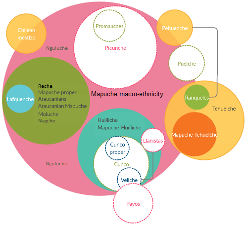
The Mapuche ( (Mapuche & Spanish: )) are a group of indigenous inhabitants of south-central Chile and southwestern Argentina, including parts of Patagonia. The collective term refers to a wide-ranging ethnicity composed of various groups who shared a common social, religious, and economic structure, as well as a common linguistic heritage as Mapudungun speakers. Their habitat once extended from Aconcagua Valley to Chiloé Archipelago and later spread eastward to Puelmapu, a land comprising part of the Argentine pampa and Patagonia. Today the collective group makes up over 80% of the indigenous peoples in Chile, and about 9% of the total Chilean population. The Mapuche are particularly concentrated in the Araucanía region. Many have migrated from rural areas to the cities of Santiago and Buenos Aires for economic opportunities. The Mapuche traditional economy is based on agriculture; their traditional social organization consists of extended families, under the direction of a ... [...More Info...] [...Related Items...] OR: [Wikipedia] [Google] [Baidu] |
Lo Barnechea
Lo Barnechea is a commune located in the northeastern zone of Santiago de Chile, northeastern sector of the province of Santiago and its area corresponds to 48% of this province. Its urban boundaries are: to the north with Los Andes, Chile, Los Andes of the Valparaíso Region, Valparaíso region, to the west with Colina, Chile, Colina, to the southwest with Vitacura and Huechuraba, to the south with Las Condes and to the east with San José de Maipo. It developed around the old rural town of Lo Barnechea. Its population is heterogeneous, as it is inhabited by high and medium-high income families in sectors such as La Dehesa, Los Trapenses and El Arrayán, and also by medium-low and low income families, mainly in the town of Lo Barnechea, Población La Ermita and Cerro Dieciocho. History Lo Barnechea has had a long human occupation for thousands of years. Before the Incas, it was occupied by the Llolleo culture and the Bato tradition, and after them, the Aconcagua culture, the ... [...More Info...] [...Related Items...] OR: [Wikipedia] [Google] [Baidu] |
Santiago Province, Chile
Santiago Province ( es, Provincia de Santiago) is one of the six provinces of the Santiago Metropolitan Region (RM) of central Chile. It encompasses the majority of the population of that region, including 31 of the 36 communities of Greater Santiago. The province spans . Administration As a province, Santiago is a second-level administrative division of Chile. As its capital is also the regional capital, the duties of the provincial delegate are instead carried out by the regional delegate of the Santiago Metropolitan Region who is appointed by the president. Communes The province comprises 32 communes (Spanish: ''comunas''), each governed by a municipality consisting of an alcalde and municipal council. Climate and natural features The climate of the Santiago Province, and generally of the Metropolitan Region is temperate Mediterranean cold, of the kind called ''continental''. Precipitation is concentrated in the winter months, generally as snow over 1000 m above sea level an ... [...More Info...] [...Related Items...] OR: [Wikipedia] [Google] [Baidu] |
Mapudungun Language
Mapuche (, Mapuche & Spanish: , or Mapudungun; from ' 'land' and ' 'speak, speech') is an Araucanian language related to Huilliche spoken in south-central Chile and west-central Argentina by the Mapuche people (from ''mapu'' 'land' and ''che'' 'people'). It is also spelled Mapuzugun and Mapudungu. It was formerly known as Araucanian, the name given to the Mapuche by the Spaniards; the Mapuche avoid it as a remnant of Spanish colonialism. Mapudungun is not an official language of the countries Chile and Argentina, receiving virtually no government support throughout its history. However, since 2013, Mapuche, along with Spanish, has been granted the status of an official language by the local government of Galvarino, one of the many Communes of Chile. It is not used as a language of instruction in either country's educational system despite the Chilean government's commitment to provide full access to education in Mapuche areas in southern Chile. There is an ongoing political d ... [...More Info...] [...Related Items...] OR: [Wikipedia] [Google] [Baidu] |

.png)
.jpg)


