|
Havelland Luch
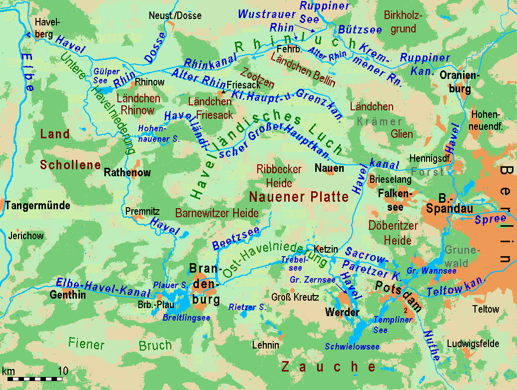
The Havelland Luch (german: Havelländisches Luch) is a lowland area inside a bend of the River Havel west of Berlin, and forms the heart of the Havelland region. Location The '' luch'', a former marshland, lies in a basin that is part of the Berlin ''urstromtal'', a meltwater valley that was formed here during the Weichselian glaciation about 18,000 years ago. It covers an area of about . To the east and northeast the Havelland Luch borders on a region called the '' Ländchen Glien'', to the south on the Nauen Plateau, to the west on the Rathenow moraine region, the '' Ländchen Friesack'' and the Zootzen. To the north it is separated from '' Ländchen Bellin'' by the ''Rhinluch'' region. Geology The Havelland Luch is mainly characterized by fen peat soils and peat soils that dried out after the land was drained. There are large areas where periglacial or fluviatile valley sands reach the surface. Mounds of ground moraine, more than ten metres high, pierce the s ... [...More Info...] [...Related Items...] OR: [Wikipedia] [Google] [Baidu] |
Havelland FHSW
Geographically, the Havelland is the region around which the River Havel flows in a U-shape between Oranienburg to the northeast and Rhinow to the northwest. The northern boundary of the Havelland is formed by the River Rhin and the Rhin Canal. In the history of Brandenburg, the Havelland represents a historic region. In the heart of the Havelland is the Landkreis Havelland, county of the same name. In addition the Havelland includes the south of Ruppin Land with the Rhinluch, the western part of Berlin's Spandau, parts of Potsdam, the town of Brandenburg an der Havel and several villages in the county of Potsdam-Mittelmark. The Tourist Association of Havelland has chosen a rather different boundary. It covers the county of Havelland, the town of Brandenburg an der Havel and the northern part of the county of Potsdam-Mittelmark, including communities south of the Havel river, that belong to the region of Zauche. The writer Theodor Fontane described the Havelland as well as the ... [...More Info...] [...Related Items...] OR: [Wikipedia] [Google] [Baidu] |
Periglacial
Periglaciation (adjective: "periglacial", also referring to places at the edges of glacial areas) describes geomorphic processes that result from seasonal thawing of snow in areas of permafrost, the runoff from which refreezes in ice wedges and other structures. "Periglacial" suggests an environment located on the margin of past glaciers. However, freeze and thaw cycles influence landscapes outside areas of past glaciation. Therefore, periglacial environments are anywhere that freezing and thawing modify the landscape in a significant manner. Tundra is a common ecological community in periglacial areas. History Periglaciation became a distinct subject within the study of geology after Walery Łoziński, a Polish geologist, introduced the term in 1909. Łoziński drew upon the early work of Johan Gunnar Andersson. According to Alfred Jahn, his introduction of his work at the 1910 International Geological Congress held in Stockholm caused significant discussion. In the field trip ... [...More Info...] [...Related Items...] OR: [Wikipedia] [Google] [Baidu] |
Havel Canal
The Havel Canal, or Havelkanal in German, is a canal in the German state of Brandenburg. It provides an alternate route to the River Havel, between Hennigsdorf and Paretz, thus avoiding a passage through the waterways of Berlin between Spandau and Potsdam. Construction of the canal was authorised by the government of East Germany in April 1951. After an extraordinarily short construction period of 13 months, the canal was opened in June 1952, thus allowing East German vessels to avoid transiting parts of the River Havel within the political control of West Berlin West Berlin (german: Berlin (West) or , ) was a political enclave which comprised the western part of Berlin during the years of the Cold War. Although West Berlin was de jure not part of West Germany, lacked any sovereignty, and was under mi .... Besides its political and military advantages, the canal also allowed large vessels to avoid the (then) small lock at Spandau and reduced the distance travelled by . T ... [...More Info...] [...Related Items...] OR: [Wikipedia] [Google] [Baidu] |
Rhin
The Rhin is a long river in Brandenburg, Germany, right tributary to the river Havel. It flows through the city Neuruppin and several lakes. A few kilometres downstream from Rhinow it flows into the Havel, about upstream from where the Havel meets the Elbe. File:Zermuetzel_bridge_Rhin.jpg, In Neuruppin-Zermützel File:Wustrau_Wustrauer_Rhin.jpg, Wustrauer Rhin in Fehrbellin Fehrbellin is a municipality in Germany, located 60 km NW of Berlin. It had 9,310 inhabitants as of 2005, but has since declined to 8,606 inhabitants in 2012. History In 1675, the Battle of Fehrbellin was fought there, in which the troops of ...-Wustrau File:Fehrbellin_Wustrauer_Rhin.jpg, Wustrauer Rhin in Fehrbellin File:Fehrbellin_Wall_bridge.jpg, Bützrhin near Fehrbellin-Wall Rivers of Brandenburg Rivers of Germany {{Brandenburg-river-stub ... [...More Info...] [...Related Items...] OR: [Wikipedia] [Google] [Baidu] |
Grassland
A grassland is an area where the vegetation is dominated by grasses (Poaceae). However, sedge (Cyperaceae) and rush (Juncaceae) can also be found along with variable proportions of legumes, like clover, and other herbs. Grasslands occur naturally on all continents except Antarctica and are found in most ecoregions of the Earth. Furthermore, grasslands are one of the largest biomes on earth and dominate the landscape worldwide. There are different types of grasslands: natural grasslands, semi-natural grasslands, and agricultural grasslands. They cover 31–69% of the Earth's land area. Definitions Included among the variety of definitions for grasslands are: * "...any plant community, including harvested forages, in which grasses and/or legumes make up the dominant vegetation." * "...terrestrial ecosystems dominated by herbaceous and shrub vegetation, and maintained by fire, grazing, drought and/or freezing temperatures." (Pilot Assessment of Global Ecosystems, 2000) * "A ... [...More Info...] [...Related Items...] OR: [Wikipedia] [Google] [Baidu] |
Arable Land
Arable land (from the la, arabilis, "able to be ploughed") is any land capable of being ploughed and used to grow crops.''Oxford English Dictionary'', "arable, ''adj''. and ''n.''" Oxford University Press (Oxford), 2013. Alternatively, for the purposes of agricultural statistics, the term often has a more precise definition: A more concise definition appearing in the Eurostat glossary similarly refers to actual rather than potential uses: "land worked (ploughed or tilled) regularly, generally under a system of crop rotation". In Britain, arable land has traditionally been contrasted with pasturable land such as heaths, which could be used for sheep-rearing but not as farmland. Arable land area According to the Food and Agriculture Organization of the United Nations, in 2013, the world's arable land amounted to 1.407 billion hectares, out of a total of 4.924 billion hectares of land used for agriculture. Arable land (hectares per person) Non-arable land ... [...More Info...] [...Related Items...] OR: [Wikipedia] [Google] [Baidu] |
Land Improvement
Land development is the alteration of landscape in any number of ways such as: * Changing landforms from a natural or semi-natural state for a purpose such as agriculture or House, housing * subdivision (land), Subdividing real estate into Lot (real estate), lots, typically for the purpose of building homes * Real estate development or changing its purpose, for example by converting an unused factory complex into a condominium. Economic aspects In an economic context, land development is also sometimes advertised as land improvement or land amelioration. It refers to investment making land more usable by humans. For accounting purposes it refers to any variety of projects that increase the property value, value of the process . Most are depreciable, but some land improvements are not able to be depreciated because a useful life cannot be determined. Home building and containment are two of the most common and the oldest types of development. In an Urban development, urban context ... [...More Info...] [...Related Items...] OR: [Wikipedia] [Google] [Baidu] |
Paulinenaue
Paulinenaue is a municipality in the Havelland district, in Brandenburg, Germany Germany,, officially the Federal Republic of Germany, is a country in Central Europe. It is the second most populous country in Europe after Russia, and the most populous member state of the European Union. Germany is situated betwe .... Demography References Localities in Havelland {{Brandenburg-geo-stub ... [...More Info...] [...Related Items...] OR: [Wikipedia] [Google] [Baidu] |


