|
Goudier Island
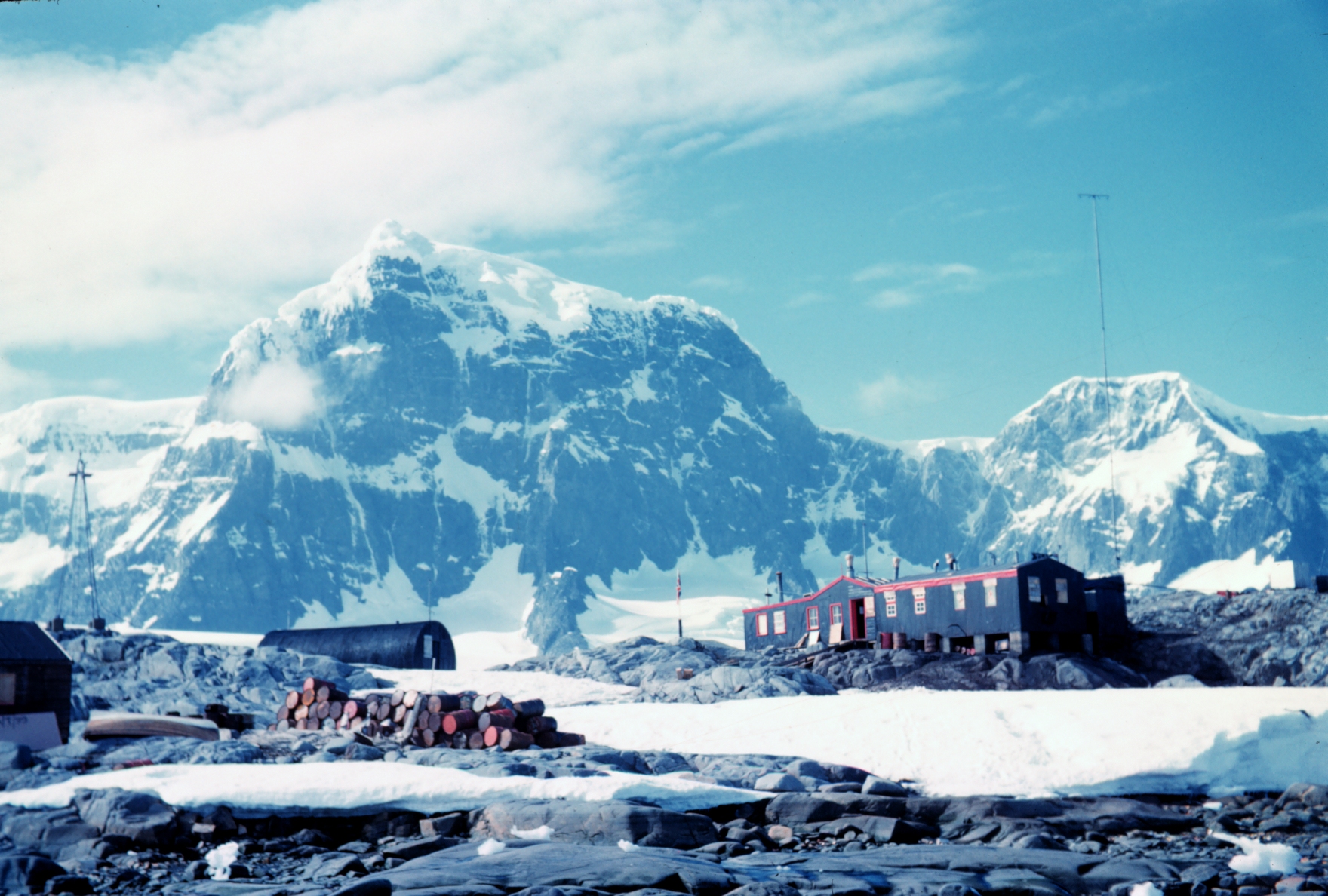
Goudier Island () is a small island with an appearance of bare, polished rock, lying north of Jougla Point in the harbour of Port Lockroy, Wiencke Island, in the Palmer Archipelago. It was discovered by the French Antarctic Expedition, 1903–05, under Jean-Baptiste Charcot, and named after E. Goudier, chief engineer of the expedition ship ''Français''. Operation Tabarin established a research base, station A, on the island in 1944. Research continued until 1962 when operations were transferred to Station F (Faraday station) on the Argentine Islands The Argentine Islands are a group of islands in the Wilhelm Archipelago of Antarctica, situated southwest of Petermann Island, and northwest of Cape Tuxen on Kyiv Peninsula in Graham Land. They were discovered by the French Antarctic Expedition .... It was restored in 1996 and is now one of the most popular tourist attractions in Antarctica. See also * List of Antarctic and subantarctic islands * Sinker Rock References ... [...More Info...] [...Related Items...] OR: [Wikipedia] [Google] [Baidu] |
Port Lockroy
Port Lockroy is a bay forming a natural harbour on the north-western shore of Wiencke Island in the Palmer Archipelago to the west of the Antarctic Peninsula. The Antarctic base with the same name, situated on Goudier Island in this bay, includes the most southerly operational post office in the world. The base was left unstaffed from 2020 to 2022 due to the COVID-19 pandemic, though the museum house remained open to individual visits. On 4 October 2022 it was announced that a team of 4 women had been chosen to return to open the base for the summer 2022/23 season. History The bay was discovered in 1904 and named after Edouard Lockroy, a French politician and Vice President of the Chamber of Deputies, who assisted Jean-Baptiste Charcot in obtaining government funding for his French Antarctic Expedition. The harbour was used for whaling between 1911 and 1931. During World War II, the British military Operation Tabarin established the Port Lockroy Station A on tiny Goudier ... [...More Info...] [...Related Items...] OR: [Wikipedia] [Google] [Baidu] |
Jougla Point
Jougla Point () is a point forming the west side of the entrance to Alice Creek in Port Lockroy, lying on the west side of Wiencke Island, in the Palmer Archipelago, Antarctica. It was discovered and named by the French Antarctic Expedition, 1903–05, under Jean-Baptiste Charcot, who considered it to be a peninsula A peninsula (; ) is a landform that extends from a mainland and is surrounded by water on most, but not all of its borders. A peninsula is also sometimes defined as a piece of land bordered by water on three of its sides. Peninsulas exist on all .... Because of its small size the term point is considered more appropriate. References External linksSecretariat of the Antarctic Treaty Visitor Guidelines and peninsula description Headlands of the Palmer Archipelago {{PalmerArchipelago-geo-stub ... [...More Info...] [...Related Items...] OR: [Wikipedia] [Google] [Baidu] |
Port Lockroy
Port Lockroy is a bay forming a natural harbour on the north-western shore of Wiencke Island in the Palmer Archipelago to the west of the Antarctic Peninsula. The Antarctic base with the same name, situated on Goudier Island in this bay, includes the most southerly operational post office in the world. The base was left unstaffed from 2020 to 2022 due to the COVID-19 pandemic, though the museum house remained open to individual visits. On 4 October 2022 it was announced that a team of 4 women had been chosen to return to open the base for the summer 2022/23 season. History The bay was discovered in 1904 and named after Edouard Lockroy, a French politician and Vice President of the Chamber of Deputies, who assisted Jean-Baptiste Charcot in obtaining government funding for his French Antarctic Expedition. The harbour was used for whaling between 1911 and 1931. During World War II, the British military Operation Tabarin established the Port Lockroy Station A on tiny Goudier ... [...More Info...] [...Related Items...] OR: [Wikipedia] [Google] [Baidu] |
Wiencke Island
Wiencke Island is an island long and from wide, about in area, the southernmost of the major islands of the Palmer Archipelago, lying between Anvers Island to its north across the Neumayer Channel and the west coast of the Antarctic Peninsula to its east across the Gerlache Strait. Description The rocky island is mostly covered by glaciers, snow and ice. Some small rocky beaches lie on the western and northern sides of the island. There, some grasses, moss and lichens can be found. There are three mountain ridges, with Nemo Peak (Antarctica), Nemo Peak, high, to the north-west; Nipple Peak to the north-east; and Luigi Peak, high, to the south-west. Luigi Peak is the island's summit, despite it never having been completely surveyed. Wiencke's northernmost point is Cape Astrup, a bold, dark-colored bluff discovered by the Belgian Antarctic Expedition, 1897–99. It was named by Adrien de Gerlache for Eivind Astrup, Norway, Norwegian Arctic explorer and member of Robert ... [...More Info...] [...Related Items...] OR: [Wikipedia] [Google] [Baidu] |
Palmer Archipelago
Palmer Archipelago, also known as Antarctic Archipelago, Archipiélago Palmer, Antarktiske Arkipel or Palmer Inseln, is a group of islands off the northwestern coast of the Antarctic Peninsula. It extends from Tower Island in the north to Anvers Island in the south. It is separated by the Gerlache and Bismarck straits from the Antarctic Peninsula and Wilhelm Archipelago, respectively. Palmer Archipelago is located at . History Adrien de Gerlache, leader of the Belgian Antarctic Expedition (1897–1899), discovered the archipelago in 1898. He named it Archipelago Palmer for American Captain Nathaniel Palmer, who navigated these waters in 1820. Both Argentina and the United Kingdom The United Kingdom of Great Britain and Northern Ireland, commonly known as the United Kingdom (UK) or Britain, is a country in Europe, off the north-western coast of the continental mainland. It comprises England, Scotland, Wales and North ... have operated research stations there. Islands ... [...More Info...] [...Related Items...] OR: [Wikipedia] [Google] [Baidu] |
French Antarctic Expedition, 1903–05
The French Antarctic Expedition is any of several French expeditions in Antarctica. First expedition In 1772, Yves-Joseph de Kerguelen-Trémarec and the naturalist Jean Guillaume Bruguière sailed to the Antarctic region in search of the fabled Terra Australis. Kerguelen-Trémarec took possession of various Antarctic territories for France, including what would later be called the Kerguelen Islands. In Kerguelen-Trémarec's report to King Louis XV, he greatly overestimated the value of the Kerguelen Islands. The King sent him on a second expedition to Kerguelen in late 1773. When it became clear that these islands were desolate, useless, and not the Terra Australis, he was sent to prison. Second expedition In 1837, during an 1837–1840 expedition across the deep southern hemisphere, Captain Jules Dumont d'Urville sailed his ship ''Astrolabe'' along a coastal area of Antarctica which he later named Adélie Land, in honor of his wife. During the Antarctic part of this expedi ... [...More Info...] [...Related Items...] OR: [Wikipedia] [Google] [Baidu] |
Jean-Baptiste Charcot
Jean-Baptiste-Étienne-Auguste Charcot (15 July 1867 – 16 September 1936), born in Neuilly-sur-Seine, was a French scientist, medical doctor and polar scientist. His father was the neurologist Jean-Martin Charcot (1825–1893). Life Jean-Baptiste Charcot was appointed leader of the French Antarctic Expedition with the ship ''Français'' exploring the west coast of Graham Land from 1904 until 1907. The expedition reached Adelaide Island in 1905 and took pictures of the Palmer Archipelago and Loubet Coast. From 1908 until 1910, another expedition followed with the ship '' Pourquoi Pas ?'', exploring the Bellingshausen Sea and the Amundsen Sea and discovering Loubet Land, Marguerite Bay, Mount Boland and Charcot Island, which was named after his father, Jean-Martin Charcot. anhere./ref> He named Hugo Island after Victor Hugo, the grandfather of his wife, Jeanne Hugo. Later on, Jean-Baptiste Charcot explored Rockall in 1921 and Eastern Greenland and Svalbard from 1925 until 1 ... [...More Info...] [...Related Items...] OR: [Wikipedia] [Google] [Baidu] |
Operation Tabarin
Operation Tabarin was the code name for a secret British expedition to the Antarctic during World War Two, operational 1943–46. Conducted by the Admiralty on behalf of the Colonial Office, its primary objective was to strengthen British claims to sovereignty of the British territory of the Falkland Islands Dependencies (FID), to which Argentina and Chile had made counter claims since the outbreak of war. This was done by establishing permanently occupied bases, carrying out administrative activities such as postal services and undertaking scientific research. The meteorological observations made aided Allied shipping in the South Atlantic Ocean. Following Cabinet approval in January 1943, there was an intensive period of planning, recruitment and procurement, before the expedition left the UK in November 1943, led by Lieutenant-Commander James Marr. Two bases were established in early 1944 – firstly, Base B, at Deception Island, South Shetland Islands, and later the main base, ... [...More Info...] [...Related Items...] OR: [Wikipedia] [Google] [Baidu] |
Vernadsky Research Base
The Vernadsky Research Base ( uk, Антарктична станція Академік Вернадський) is a Ukrainian Antarctic Station at Marina Point on Galindez Island in the Argentine Islands, not far from Kyiv Peninsula. The region is under territorial claims between three countries (see Territorial claims in Antarctica). The single Ukrainian Antarctic station is named after the mineralogist Vladimir Vernadsky (1863–1945) who was the first president of the National Academy of Sciences of Ukraine. A British research base was established in 1947 and transferred to Ukraine in 1996.Akademik Vernadskyi Antarctic station, chronology of events (Станція АКАДЕМ ... [...More Info...] [...Related Items...] OR: [Wikipedia] [Google] [Baidu] |
Argentine Islands
The Argentine Islands are a group of islands in the Wilhelm Archipelago of Antarctica, situated southwest of Petermann Island, and northwest of Cape Tuxen on Kyiv Peninsula in Graham Land. They were discovered by the French Antarctic Expedition, 1903–05, under Jean-Baptiste Charcot, and named by him for the Argentine Republic, in appreciation of that government's support of his expedition. History The British Graham Land Expedition under John Riddoch Rymill was based in the Argentine Islands in 1935 and conducted a thorough survey of them. The expedition built a hut on Winter Island (Antarctica), Winter Island, which was used as their northern base; it was left in place at the end of the expedition, but destroyed circa 1946. The following year, the British Falkland Islands Dependencies Survey established a permanent base on the same site, as "Vernadsky Research Base, Base F" (or "Argentine Islands"); the main building from this base, Wordie House, is now a protected Historic S ... [...More Info...] [...Related Items...] OR: [Wikipedia] [Google] [Baidu] |
Sinker Rock
Sinker Rock () is a rock off the north tip of Goudier Island, near the center of the harbor of Port Lockroy, in the Palmer Archipelago. Rocks were charted in this position by the French Antarctic Expedition, 1903–05, under Charcot. So named by the Falkland Islands Dependencies Survey The British Antarctic Survey (BAS) is the United Kingdom's national polar research institute. It has a dual purpose, to conduct polar science, enabling better understanding of global issues, and to provide an active presence in the Antarctic on ... (FIDS) in 1944 because a sinker was laid near this rock for a boat mooring. Rock formations of the Palmer Archipelago {{PalmerArchipelago-geo-stub ... [...More Info...] [...Related Items...] OR: [Wikipedia] [Google] [Baidu] |


.jpg)
.jpg)