|
French Antarctic Expedition, 1903–05
The French Antarctic Expedition is any of several French expeditions in Antarctica. 1837–1840 In 1837, during an 1837–1840 expedition across the deep southern hemisphere, Captain Jules Dumont d'Urville sailed his ship ''Astrolabe'' along a coastal area of Antarctica which he later named Adélie Land, in honor of his wife. During the Antarctic part of this expedition, Dumont d'Urville team performed the first experiments to determine the approximate position of the South magnetic pole, and landed on Débarquement Rock in the Géologie Archipelago, () just 4 km from the mainland, where he took mineral and animal samples. On his return to France in 1840 he was made rear admiral. 1904–1907 Jean-Baptiste Charcot was appointed leader of a 1904–1907 French Antarctic Expedition, aboard the ship ''Français'', exploring the west coast of Graham Land portion of the Antarctic Peninsula. The expedition reached Adelaide Island in 1905 and took pictures of the Palmer ... [...More Info...] [...Related Items...] OR: [Wikipedia] [Google] [Baidu] |
John Biscoe
John Biscoe (28 April 1794 – 1843) was an English mariner and explorer who commanded the first expedition known to have sighted the areas named Enderby Land and Graham Land along the coast of Antarctica. The expedition also found a number of islands in the vicinity of Graham Land, including the Biscoe Islands that were named after him. Early life Biscoe was born in Enfield, Middlesex, England. In March 1812, aged seventeen, he joined the Royal Navy and served during the 1812–1815 war against the United States. By the time of his discharge in 1815, he had become a justice Master. Thereafter he sailed on board merchant shipping as a mate or master, mostly to the East or West Indies. Southern Ocean expedition, 1830–1833 In 1830, the whaling company Samuel Enderby & Sons appointed Biscoe master of the brig ''Tula'' and leader of an expedition to find new sealing grounds in the Southern Ocean. Accompanied by the cutter ''Lively'', the ''Tula'' left London and by Dec ... [...More Info...] [...Related Items...] OR: [Wikipedia] [Google] [Baidu] |
Nansen Island
Nansen Island () is the largest of the islands lying in Wilhelmina Bay off the west coast of Graham Land, Antarctica. Location Nansen Island is off the Danco Coast on the west side of the Antarctic Peninsula. It is in the northeast of Wilhelmina Bay, to the southeast of Gerlache Strait. Charlotte Bay is to the east. Forbidden Plateau on the mainland is to the south. Discovery and name Nansen Island was discovered by the Belgian Antarctic Expedition (BelgAE; 1897–1899) under Adrien de Gerlache and named for Dr. Fridtjof Nansen, noted Arctic explorer. Features Features and nearby features include: Patcha Point . The south end of Nansen Island. Charted by the BelgAE under Gerlache, 1897-99. Named by the UK Antarctic Place-Names Committee (UK-APC) in 1960 for Jan Patcha, helicopter pilot with the Falkland Islands and Dependencies Aerial Survey Expedition (FIDASE) which photographed this area in 1956-57. Bearing Island . A small island lying midway between Nansen and ... [...More Info...] [...Related Items...] OR: [Wikipedia] [Google] [Baidu] |
Fridtjof Nansen
Fridtjof Wedel-Jarlsberg Nansen (; 10 October 1861 – 13 May 1930) was a Norwegian polymath and Nobel Peace Prize laureate. He gained prominence at various points in his life as an explorer, scientist, diplomat, humanitarian and co-founded the Fatherland League (Norway), Fatherland League. He led the team that made the first crossing of the Greenland interior in 1888, traversing the island on cross-country skis. He won international fame after reaching a record northern latitude of 86°14′ during his Nansen's Fram expedition, ''Fram'' expedition of 1893–1896. Although he retired from exploration after his return to Norway, his techniques of polar travel and his innovations in equipment and clothing influenced a generation of subsequent Arctic and Antarctic expeditions. He was elected an International Member of the American Philosophical Society in 1897. Nansen studied zoology at the Royal Frederick University in Christiania, Norway, Christiania and later worked as a curato ... [...More Info...] [...Related Items...] OR: [Wikipedia] [Google] [Baidu] |
Lavoisier Island
Lavoisier Island is an island long and wide, lying between Rabot and Watkins Islands in the Biscoe Islands, Antarctica. It is separated from Renaud Island and Rabot Island to the northeast by Pendleton Strait, from Watkins Island to the southwest by Lewis Sound, and from Krogh Island to the west-southwest by Vladigerov Passage. Lavoisier Island is named ''Isla Serrano'' by Chile and ''isla Mitre'' by Argentina. The island was first charted by the French Antarctic Expedition, 1903–05, under Jean-Baptiste Charcot, and named "Ile Nansen" after Fridtjof Nansen, Norwegian Arctic explorer. To avoid confusion with Nansen Island (q.v.) in Wilhelmina Bay, the UK-APC recommended in 1960 that the island be renamed for Antoine Laurent Lavoisier, French chemist who pioneered the study of metabolism. Winslow Rock Winslow Rock is a rock close off the east side of Lavoisier Island, Biscoe Islands. Mapped from surveys by Falkland Islands Dependencies Survey The Falkland Islands ... [...More Info...] [...Related Items...] OR: [Wikipedia] [Google] [Baidu] |
Trojan Range
The Trojan Range () is a mountain range rising to , extending northward from Mount Francais along the east side of Iliad Glacier, Anvers Island, in the Palmer Archipelago of the British Antarctic Territory. It was surveyed by the Falkland Islands Dependencies Survey (FIDS) in 1955 and named by the UK Antarctic Place-Names Committee (UK-APC) for the Trojans, one of the opposing sides in the Trojan War in Homer's ''Iliad''. List of geographical features Mountains * Mount Français () is a majestic, snow-covered mountain of 2,760 m, which forms the summit of Anvers Island, standing southeast of the center of the island and 6 miles north of Borgen Bay. It was first seen by the Belgian Antarctic Expedition, who explored the southeast coast of the island in 1898 and later sighted by the French Antarctic Expedition, 1903–05, under Jean-Baptiste Charcot, who named it for the expedition ship '' Francais''. * Mount Hector () is a snow-covered mountain, 2,225 metres, between Moun ... [...More Info...] [...Related Items...] OR: [Wikipedia] [Google] [Baidu] |
Arthur Harbour
Arthur Harbour () is a small harbour entered between Bonaparte Point and Amsler Island on the south-west coast of Anvers Island in the Palmer Archipelago of Antarctica. History Arthur Harbour was roughly charted by the French Antarctic Expedition (1903–1905) under Jean-Baptiste Charcot. It was surveyed in more detail in 1955 by the Falkland Islands Dependencies Survey (FIDS), who established a station near the head of the harbour. It was named by the United Kingdom Antarctic Place-names Committee (UK-APC) in 1956 after Oswald Raynor Arthur, then Governor of the Falkland Islands. Station N Arthur Harbour was the location of the British research Station N, which was active from 28 February 1955 to 10 January 1958. The Station was loaned to the United States government on 2 July 1963. In January 1965, it was converted into a biological laboratory for use by American personnel from nearby Palmer Station. Station N was destroyed by fire on 28 December 1971, while under renovatio ... [...More Info...] [...Related Items...] OR: [Wikipedia] [Google] [Baidu] |
Watkins Island
Watkins Island is a low lying, ice-covered island long, lying southwest of Lavoisier Island in the Biscoe Islands. The island was first mapped by the French Antarctic Expedition under Jean-Baptiste Charcot, 1903–05 and 1908–10, but remained unnamed until resighted by the BGLE under Rymill, 1934–1937. He gave the name Mikkelsen Island after Ejnar Mikkelsen, Danish Arctic explorer. In applying the name, Rymill was unaware of the existence of Mikkelsen Islands southwestward, named in 1908–1910 by Charcot. To avoid confusion of the two, the UK-APC The UK Antarctic Place-Names Committee (or UK-APC) is a United Kingdom government committee, part of the Foreign and Commonwealth Office, responsible for recommending names of geographical locations within the British Antarctic Territory (BAT) and ... recommended in 1952 that the Rymill naming be amended. The new name, Watkins Island, commemorates Gino Watkins, leader of the British Arctic Air Route Expedition, 1930–1931. ... [...More Info...] [...Related Items...] OR: [Wikipedia] [Google] [Baidu] |
Charles Rabot
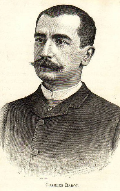
Charles Rabot (26 June 1856 in Nevers в€’ 1 February 1944 in MartignГ©-Ferchaud) was a French geographer, glaciologist, traveler, journalist, lecturer, translation, translator, and explorer. He was also the first person to climb Kebnekaise, the tallest mountain in Sweden, which he accomplished in 1883. He led his first expedition to Spitsbergen in 1882 on the ship ''Petit Paris''. Ten years later, he embarked on a voyage on the ship ''La Mancha'', for a mapping mission, redrawing the map of the glacier Svartisen. He crossed Spitsbergen west to east and surveyed Prins Karls Forland. He was also a passionate ethnographer with the study of some Arctic and Volga peoples to the east and west of the Urals: Chuvash people, Cheremiss, Permiak, Zyrian, Khanty people, Khanty (Ostiaks) and Samoyedic peoples, Samoyeds. He published numerous articles on the above subjects, and also wrote and translated many books on Arctic exploration and sciences. The French base located at Ny-Г…lesund bears ... [...More Info...] [...Related Items...] OR: [Wikipedia] [Google] [Baidu] |
Rabot Island
Rabot Island is an island long and wide, lying south of Renaud Island in the Biscoe Islands. First charted by the French Antarctic Expedition, 1903–05, under Jean-Baptiste Charcot, who named it for Charles Rabot. Originally discovered by John Biscoe John Biscoe (28 April 1794 – 1843) was an English mariner and explorer who commanded the first expedition known to have sighted the areas named Enderby Land and Graham Land along the coast of Antarctica. The expedition also found a number of is .... See also * List of Antarctic islands south of 60° S * Monflier Point, marks the southwest end of Rabot Island * Rodman Passage References External links * Islands of the Biscoe Islands {{Biscoes-geo-stub ... [...More Info...] [...Related Items...] OR: [Wikipedia] [Google] [Baidu] |
President Of France
The president of France, officially the president of the French Republic (), is the executive head of state of France, and the commander-in-chief of the French Armed Forces. As the presidency is the supreme magistracy of the country, the position is the highest office in France. The powers, functions and duties of prior presidential offices, in addition to their relation with the prime minister and government of France, have over time differed with the various constitutional documents since the Second Republic. The president of the French Republic is the co-prince of Andorra, grand master of the Legion of Honour and of the National Order of Merit. The officeholder is also honorary proto-canon of the Archbasilica of Saint John Lateran in Rome, although some have rejected the title in the past. The current president is Emmanuel Macron, who succeeded François Hollande on 14 May 2017 following the 2017 presidential election, and was inaugurated for a second term on 7 May ... [...More Info...] [...Related Items...] OR: [Wikipedia] [Google] [Baidu] |
Г‰mile Loubet
Émile François Loubet (; 30 December 183820 December 1929) was the 45th Prime Minister of France from February to December 1892 and later President of France from 1899 to 1906. Trained in law, he became Mayor (France), mayor of Montélimar, where he was noted as a forceful orator. He was elected to the Chamber of Deputies in 1876 and the Senate in 1885. He was appointed as a Republican minister under Carnot and Ribot. He was briefly Prime Minister of France in 1892. As President, he saw the successful Exposition Universelle (1900), Paris Exhibition of 1900, and the forging of the Entente Cordiale with the United Kingdom of Great Britain and Ireland, resolving their sharp differences over the Boer War and the Dreyfus Affair. Early life Loubet was born on 30 December 1838, the son of a peasant proprietor and Mayor (France), mayor of Marsanne, Drôme, Marsanne (Drôme). Admitted to the Parisian bar in 1862, he took his doctorate in law the next year. He was still a student when h ... [...More Info...] [...Related Items...] OR: [Wikipedia] [Google] [Baidu] |


