|
Gay Street (Baltimore)
Gay Street is a street in Baltimore, Maryland that gets its name from Nicholas Ruxton Gay, who surveyed the area in 1747. It begins at the intersection of East Pratt Street near the Baltimore World Trade Center (at the Inner Harbor) and proceeds north and east through Baltimore until it crosses Orleans Street ( U.S. Route 40) and becomes Ensor Street. According to the Baltimore City web site, the Gay Street corridor escaped the Great Baltimore Fire in 1904. Urban development in the 1970s essentially cut Gay Street in half in east Baltimore. Old Town Mall, a retail strip that spans from Orleans to Aisquith and Monument Streets, was converted from a working street to a pedestrian mall. The street from that point north to Chase Street was essentially paved over, and the land was fitted into the surrounding street grid. Despite the rebuild, there are still a few housing units in the area that still follow the angular path that Gay Street cut through the neighborhood. Just north of ... [...More Info...] [...Related Items...] OR: [Wikipedia] [Google] [Baidu] |
Baltimore
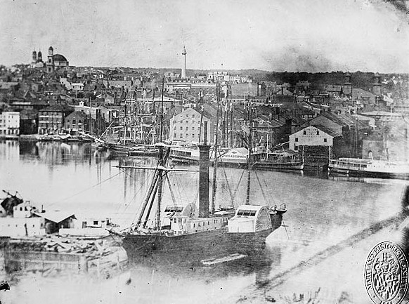
Baltimore ( , locally: or ) is the most populous city in the U.S. state of Maryland, fourth most populous city in the Mid-Atlantic, and the 30th most populous city in the United States with a population of 585,708 in 2020. Baltimore was designated an independent city by the Constitution of Maryland in 1851, and today is the most populous independent city in the United States. As of 2021, the population of the Baltimore metropolitan area was estimated to be 2,838,327, making it the 20th largest metropolitan area in the country. Baltimore is located about north northeast of Washington, D.C., making it a principal city in the Washington–Baltimore combined statistical area (CSA), the third-largest CSA in the nation, with a 2021 estimated population of 9,946,526. Prior to European colonization, the Baltimore region was used as hunting grounds by the Susquehannock Native Americans, who were primarily settled further northwest than where the city was later built. Colonist ... [...More Info...] [...Related Items...] OR: [Wikipedia] [Google] [Baidu] |
Pratt Street
Pratt Street is a major street in Baltimore, Maryland, United States. It forms a one-way pair of streets with Lombard Street that run west–east through downtown Baltimore. For most of their route, Pratt Street is one-way in an eastbound direction, and Lombard Street is one way westbound. Both streets begin in west Baltimore at Frederick Avenue and end in Butcher's Hill at Patterson Park Avenue. Since 2005, these streets have been open to two-way traffic from Broadway until their end at Patterson Park. Although Lombard is also a two-way street from Fulton Avenue to Martin Luther King Jr. Boulevard, Pratt is still one-way eastbound in this area. To the east of Patterson Park, both Pratt and Lombard Streets start again. Pratt continues as a side street from Linwood Avenue until Haven Street. Pratt Street has historic significance as the location of the Baltimore Riot of 1861 The Baltimore riot of 1861 (also called the "Pratt Street Riots" and the "Pratt Street Massacre") ... [...More Info...] [...Related Items...] OR: [Wikipedia] [Google] [Baidu] |
Baltimore, Maryland
Baltimore ( , locally: or ) is the most populous city in the U.S. state of Maryland, fourth most populous city in the Mid-Atlantic, and the 30th most populous city in the United States with a population of 585,708 in 2020. Baltimore was designated an independent city by the Constitution of Maryland in 1851, and today is the most populous independent city in the United States. As of 2021, the population of the Baltimore metropolitan area was estimated to be 2,838,327, making it the 20th largest metropolitan area in the country. Baltimore is located about north northeast of Washington, D.C., making it a principal city in the Washington–Baltimore combined statistical area (CSA), the third-largest CSA in the nation, with a 2021 estimated population of 9,946,526. Prior to European colonization, the Baltimore region was used as hunting grounds by the Susquehannock Native Americans, who were primarily settled further northwest than where the city was later built. Colonis ... [...More Info...] [...Related Items...] OR: [Wikipedia] [Google] [Baidu] |
Maryland
Maryland ( ) is a state in the Mid-Atlantic region of the United States. It shares borders with Virginia, West Virginia, and the District of Columbia to its south and west; Pennsylvania to its north; and Delaware and the Atlantic Ocean to its east. Baltimore is the largest city in the state, and the capital is Annapolis. Among its occasional nicknames are '' Old Line State'', the ''Free State'', and the '' Chesapeake Bay State''. It is named after Henrietta Maria, the French-born queen of England, Scotland, and Ireland, who was known then in England as Mary. Before its coastline was explored by Europeans in the 16th century, Maryland was inhabited by several groups of Native Americans – mostly by Algonquian peoples and, to a lesser degree, Iroquoian and Siouan. As one of the original Thirteen Colonies of England, Maryland was founded by George Calvert, 1st Baron Baltimore, a Catholic convert"George Calvert and Cecilius Calvert, Barons Baltimore" William Hand Browne, ... [...More Info...] [...Related Items...] OR: [Wikipedia] [Google] [Baidu] |
Baltimore World Trade Center
Located on the Inner Harbor of Baltimore, Maryland, the Baltimore World Trade Center is the world's tallest regular pentagonal-based skyscraper (the pentagonal-based JPMorgan Chase Tower in Houston is taller, but is not regular). It was designed by the architectural firm Pei Cobb Freed & Partners, with the principal architects being Henry N. Cobb and Pershing Wong. Planning and design of the building began in April 1966. Construction started in October 1973. The building was completed in January 1977, and its construction cost was of $22 million. Rising above the one-acre plaza where it stands between Pratt Street and the harbor, the building is 30 stories tall when its basement, lobby level and upper utility level are included in the count. Gross floor space covers . Major building components include of office floors, a lobby of , a basement of and of ground level plaza. Significance of building's name The building's name identifies its purpose of accommodating "activities ... [...More Info...] [...Related Items...] OR: [Wikipedia] [Google] [Baidu] |
Inner Harbor
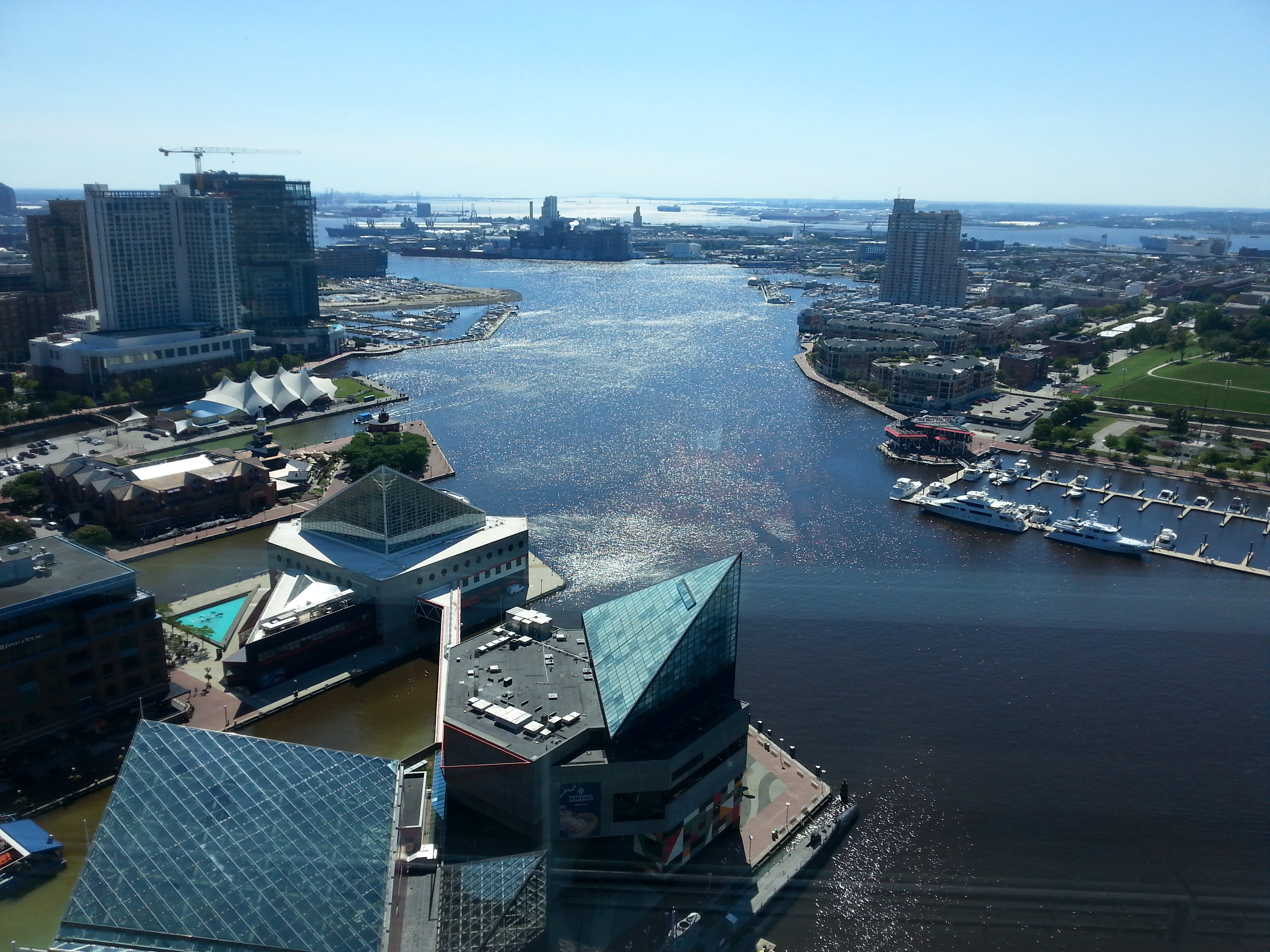
The Inner Harbor is a historic seaport, tourist attraction, and landmark of the city of Baltimore, Maryland. It was described by the Urban Land Institute in 2009 as "the model for post-industrial waterfront redevelopment around the world". The Inner Harbor is located at the mouth of Jones Falls, creating the wide and short northwest branch of the Patapsco River. The district includes any water west of a line drawn between the foot of President Street and the American Visionary Art Museum. The name "Inner Harbor" is used not just for the water but for the surrounding area of the city, with approximate street boundaries of President Street to the east, Lombard Street to the north, Greene Street to the west, and Key Highway on the south. The harbor is within walking distance of Oriole Park at Camden Yards and M&T Bank Stadium. A water taxi connects passengers to Fells Point, Canton, and Fort McHenry. History While Baltimore has been a major U.S. seaport since the 18th cent ... [...More Info...] [...Related Items...] OR: [Wikipedia] [Google] [Baidu] |
Orleans Street (Baltimore)
U.S. Route 40 (US 40) in the U.S. state of Maryland runs from Garrett County, Maryland, Garrett County in Western Maryland to Cecil County, Maryland, Cecil County in the state's northeastern corner. With a total length of , it is the longest numbered highway in Maryland. Almost half of the road concurrency (road), overlaps or parallels with Interstate 68 in Maryland, Interstate 68 (I-68) or Interstate 70 in Maryland, I-70, while the old alignment is generally known as US 40 Alternate, U.S. Route 40 Scenic, US 40 Scenic, or Maryland Route 144 (MD 144). West of Baltimore, in the Piedmont (United States), Piedmont and Appalachian Mountains / Blue Ridge Mountains, Blue Ridge region of the Western Maryland panhandle of the small state, the portions where it does not overlap an Interstate highway are mostly two-lane roads. The portion northeast of Baltimore going toward Wilmington, Delaware, Wilmington in northern Delaware and Philadelphia in southeastern Pennsylvania is a four- ... [...More Info...] [...Related Items...] OR: [Wikipedia] [Google] [Baidu] |
Great Baltimore Fire
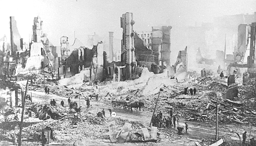
The Great Baltimore Fire raged in Baltimore, Maryland from Sunday, February 7, to Monday, February 8, 1904. More than 1,500 buildings were completely leveled, and some 1,000 severely damaged, bringing property loss from the disaster to an estimated $100 million. 1,231 firefighters helped bring the blaze under control, both professional paid truck and engine companies from the Baltimore City Fire Department (B.C.F.D.) and volunteers from the surrounding counties and outlying towns of Maryland, as well as out-of-state units that arrived on the major railroads. It destroyed much of central Baltimore, including over 1,500 buildings covering an area of some . From North Howard Street in the west and southwest, the flames spread north through the retail shopping area as far as Fayette Street and began moving eastward, pushed along by the prevailing winds. Narrowly missing the new 1900 Circuit Courthouse (now Clarence M. Mitchell, Jr. Courthouse), fire passed the historic Battle Monument ... [...More Info...] [...Related Items...] OR: [Wikipedia] [Google] [Baidu] |
Old Town Mall
The Old Town Mall or Oldtown Mall is a mostly abandoned outdoor pedestrian shopping mall in the Old Town neighborhood of Baltimore, Maryland. The mall contains 64 stores, the majority of which are closed. The area has seen many periods of revival and decline in the past 200 years since its opening, and there are currently plans by developers in the area to revitalize the mall. History Old Town and Gay Street started to become a retail area when the City of Baltimore built the Bel Air Market in 1818. The sixth market to be constructed, Bel Air was designed to be a relief farmers market to serve the increasing commercial operations surrounding the area. The market helped boost business in Old Town, and the area became a diverse, bustling middle-class neighborhood, and the proximity to the city center made it an ideal place for families and downtown workers to live. Isaac Benesch’s Great Store was here. But, when the post-war era beckoned families to the suburbs, Gay Street suff ... [...More Info...] [...Related Items...] OR: [Wikipedia] [Google] [Baidu] |
Monument Street (Baltimore)
This is a list of notable streets in the city of Baltimore, Maryland, United States. A B C D E F G H Heath St. Route 64. (MTA Maryland) K L M N O P R Ramsay st S U W Y Numbered streets In Baltimore, numbered streets are found in the north-central part of the city, mostly in the communities of Charles Village, Hampden, and Waverly. The numbered streets, which run west–east, start with 20th Street (excluding 19½ Street, a short alley crossing Howard Street), which runs parallel to and one block north of North Avenue. The highest numbered street in Baltimore is 43rd Street, which runs from York Road several block east to Marble Hall Road near Cold Spring Lane. The numbered streets correspond with the first two digits in address numbers on north–south streets in this part of the city. See also *List of roads in Baltimore County, Maryland References {{DEFAULTSORT:List Of Streets In Baltimore, Maryland Baltimor ... [...More Info...] [...Related Items...] OR: [Wikipedia] [Google] [Baidu] |
Chase Street
This is a list of notable streets in the city of Baltimore, Maryland, United States. A B C D E F G H Heath St. Route 64. (MTA Maryland) K L M N O P R Ramsay st S U W Y Numbered streets In Baltimore, numbered streets are found in the north-central part of the city, mostly in the communities of Charles Village, Hampden, and Waverly. The numbered streets, which run west–east, start with 20th Street (excluding 19½ Street, a short alley crossing Howard Street), which runs parallel to and one block north of North Avenue. The highest numbered street in Baltimore is 43rd Street, which runs from York Road several block east to Marble Hall Road near Cold Spring Lane. The numbered streets correspond with the first two digits in address numbers on north–south streets in this part of the city. See also * List of roads in Baltimore County, Maryland References {{DEFAULTSORT:List Of Streets In Baltimore, Maryland Baltimore St ... [...More Info...] [...Related Items...] OR: [Wikipedia] [Google] [Baidu] |


