|
Geology Of Quebec
The geology of Quebec involves several different geologic provinces, made up of ancient Precambrian crystalline igneous and metamorphic rock, overlain by younger sedimentary rocks and soils. Most of southern Quebec is dominated by the Grenville Province, while the vast north is divided between the large Superior Province and the Churchill Province to the east, near Labrador. Geologic History, Stratigraphy & Tectonics The Grenville Province, which dominates southern Quebec, particularly the northern shore of the St. Lawrence formed beginning in the Archean, more than 2.5 billion years ago. Geologists subdivide the Grenville Province into the Allochthon along the river itself and the more northern Parautochthon. The Parautochthon is a band running parallel to the Grenville Front, which varies in width from Labrador to northeastern Georgian Bay on Lake Huron. Parautochthonous rocks are made up composed of ancient Archean and Proterozoic rocks that are highly deformed plutonic a ... [...More Info...] [...Related Items...] OR: [Wikipedia] [Google] [Baidu] |
Quebec
Quebec ( ; )According to the Canadian government, ''Québec'' (with the acute accent) is the official name in Canadian French and ''Quebec'' (without the accent) is the province's official name in Canadian English is one of the thirteen provinces and territories of Canada. It is the largest province by area and the second-largest by population. Much of the population lives in urban areas along the St. Lawrence River, between the most populous city, Montreal, and the provincial capital, Quebec City. Quebec is the home of the Québécois nation. Located in Central Canada, the province shares land borders with Ontario to the west, Newfoundland and Labrador to the northeast, New Brunswick to the southeast, and a coastal border with Nunavut; in the south it borders Maine, New Hampshire, Vermont, and New York in the United States. Between 1534 and 1763, Quebec was called ''Canada'' and was the most developed colony in New France. Following the Seven Years' War, Quebec b ... [...More Info...] [...Related Items...] OR: [Wikipedia] [Google] [Baidu] |
Charnockite
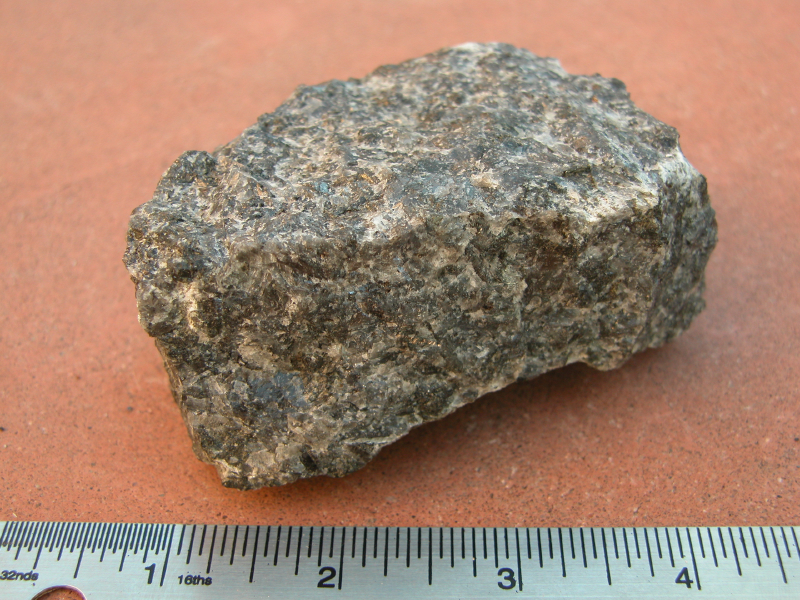
Charnockite () is any orthopyroxene-bearing quartz-feldspar rock formed at high temperature and pressure, commonly found in granulite facies metamorphic regions, ''sensu stricto'' as an endmember of the charnockite series. Charnockite series The ''charnockite suite'' or ''series'' is a particularly widespread form of granofels. Granofels are one of the few non-foliated rocks to form under relatively high temperatures and pressures. This combination is generated only deep in the crust by tectonic forces that operate on a grand scale, so granofels is a product of regional, rather than contact, metamorphism. It is formed mostly from the granite clan of rocks, or occasionally from thoroughly reconstituted clays and shales. It is of wide distribution and great importance in India, Sri Lanka, Madagascar and Africa. It was named by geologist T. H. Holland in 1893 after the tombstone of Job Charnock, in St John's Church in Kolkata, India, which is made of this rock. Composition The c ... [...More Info...] [...Related Items...] OR: [Wikipedia] [Google] [Baidu] |
Anticosti Island
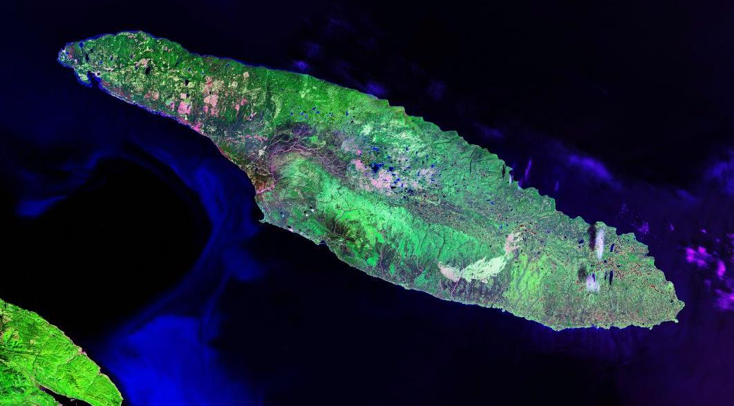
; moe, Notiskuan; mic, Natigostec , sobriquet = , image_name = RiviereHuileAnticosti.jpg , image_caption = Salmon fisherman on Rivière à l'Huile , image_map = , map_alt = , map_size = , map_caption = , pushpin_map = Canada Quebec , pushpin_label = , pushpin_label_position = , pushpin_map_alt = , pushpin_relief = , pushpin_map_caption = , coordinates = , etymology = , location = Gulf of Saint Lawrence , grid_reference = , archipelago = , waterbody = , total_islands = , major_islands = , area_km2 = 7,953 ... [...More Info...] [...Related Items...] OR: [Wikipedia] [Google] [Baidu] |
Nain Province
In Labrador, Canada, the North Atlantic Craton is known as the Nain Province. The Nain geologic province was intruded by the Nain Plutonic Suite, which divides the province into the northern Saglek block and the southern Hopedale, Newfoundland and Labrador, Hopedale block. North Atlantic Craton The North Atlantic Craton is exposed in parts of the coast of Labrador, parts of central Greenland, the Scourian Complex of northwestern Scotland and is unexposed in northern Norway. The North Atlantic Craton fragmented 2450 to 2000 million years ago. When North America and Europe rejoined, the North Atlantic Craton was triangular shaped with each side ; this unit was separated when the Labrador Sea formed 61 to 40 million years ago. The crust of the North Atlantic Craton varies between thick and its rocks are 85% Granite, granitoid gneisses. The Nain Province was intruded by the 1350- to 1290-million-year-old Nain Plutonic Suite; composite anorthosite-granitic intrusions which divide the ... [...More Info...] [...Related Items...] OR: [Wikipedia] [Google] [Baidu] |
James Bay
James Bay (french: Baie James; cr, ᐐᓂᐯᒄ, Wînipekw, dirty water) is a large body of water located on the southern end of Hudson Bay in Canada. Both bodies of water extend from the Arctic Ocean, of which James Bay is the southernmost part. Despite bordering the Canadian provinces of Quebec and Ontario, the bay and the islands within it, the largest of which is Akimiski Island, are politically part of Nunavut. Numerous waterways of the James Bay watershed have been modified with dams or diversion for several major hydroelectric projects. These waterways are also destinations for river-based recreation. Several communities are located near or alongside James Bay, including a number of Aboriginal Canadian communities, such as the Kashechewan First Nation and nine communities affiliated with the Cree of northern Quebec. As with the rest of Hudson Bay, the waters of James Bay routinely freeze over in winter. It is the last part of Hudson Bay to freeze over in winter, and the ... [...More Info...] [...Related Items...] OR: [Wikipedia] [Google] [Baidu] |
Nunavut
Nunavut ( , ; iu, ᓄᓇᕗᑦ , ; ) is the largest and northernmost Provinces and territories of Canada#Territories, territory of Canada. It was separated officially from the Northwest Territories on April 1, 1999, via the ''Nunavut Act'' and the ''Nunavut Land Claims Agreement, Nunavut Land Claims Agreement Act'', which provided this territory to the Inuit for independent government. The boundaries had been drawn in 1993. The creation of Nunavut resulted in the territorial evolution of Canada, first major change to Canada's political map in half a century since the province of Newfoundland and Labrador, Newfoundland was admitted in 1949. Nunavut comprises a major portion of Northern Canada and most of the Arctic Archipelago. Its vast territory makes it the list of the largest country subdivisions by area, fifth-largest country subdivision in the world, as well as North America's second-largest (after Greenland). The capital Iqaluit (formerly Frobisher Bay), on Baffin Islan ... [...More Info...] [...Related Items...] OR: [Wikipedia] [Google] [Baidu] |
Ungava Peninsula
The Ungava Peninsula of Nunavik, Quebec, Canada, is bounded by Hudson Bay to the west, Hudson Strait to the north, and Ungava Bay to the east. This peninsula is part of the Labrador Peninsula, and covers about . Its northernmost point is Cape Wolstenholme, which is also the northernmost point of Quebec. The peninsula is also part of the Canadian Shield, and consists entirely of treeless tundra dissected by large numbers of rivers and glacial lakes, flowing generally east–west in a parallel fashion. The peninsula was not deglaciated until 6,500 years ago (11,500 years after the Last Glacial Maximum) and is believed to have been the prehistoric centre from which the vast Laurentide Ice Sheet spread over most of North America during the last glacial epoch. Climate The climate is extremely cold (''Dfc'' in the Köppen climate classification) because the Labrador Current keeps the region (and all of northern Québec) colder in the summer than other regions at comparable latitude ... [...More Info...] [...Related Items...] OR: [Wikipedia] [Google] [Baidu] |
Superior Craton
The Superior Craton is a stable crustal block covering Quebec, Ontario, and southeast Manitoba in Canada, and northern Minnesota in the United States. It is the biggest craton among those formed during the Archean period. A craton is a large part of the Earth's crust that has been stable and subjected to very little geological changes over a long time. The size of Superior Craton is about 1,572,000 km2. The craton underwent a series of events from 4.3 to 2.57 Ga. These events included the growth, drifting and deformation of both oceanic and continental crusts. Researchers have divided the Superior Craton into many different domains based on rock types and deformation styles. These domains (grouped into western and eastern superior provinces), include the North Superior Superterrane and Wawa Terrane, among others (shown in the table below). Studies on the formation of the Superior Craton varied in progress between the western and the eastern part. For the western part, five ... [...More Info...] [...Related Items...] OR: [Wikipedia] [Google] [Baidu] |
Canadian Shield
The Canadian Shield (french: Bouclier canadien ), also called the Laurentian Plateau, is a geologic shield, a large area of exposed Precambrian igneous and high-grade metamorphic rocks. It forms the North American Craton (or Laurentia), the ancient geologic core of the North American continent. Glaciation has left the area with only a thin layer of soil, through which exposures of igneous bedrock resulting from its long volcanic history are frequently visible. As a deep, common, joined bedrock region in eastern and central Canada, the Shield stretches north from the Great Lakes to the Arctic Ocean, covering over half of Canada and most of Greenland; it also extends south into the northern reaches of the United States. Geographical extent The Canadian Shield is a physiographic division comprising four smaller physiographic provinces: the Laurentian Upland, Kazan Region, Davis and James. The shield extends into the United States as the Adirondack Mountains (connected by the Fro ... [...More Info...] [...Related Items...] OR: [Wikipedia] [Google] [Baidu] |
Gabbro
Gabbro () is a phaneritic (coarse-grained), mafic intrusive igneous rock formed from the slow cooling of magnesium-rich and iron-rich magma into a holocrystalline mass deep beneath the Earth's surface. Slow-cooling, coarse-grained gabbro is chemically equivalent to rapid-cooling, fine-grained basalt. Much of the Earth's oceanic crust is made of gabbro, formed at mid-ocean ridges. Gabbro is also found as plutons associated with continental volcanism. Due to its variant nature, the term ''gabbro'' may be applied loosely to a wide range of intrusive rocks, many of which are merely "gabbroic". By rough analogy, gabbro is to basalt as granite is to rhyolite. Etymology The term "gabbro" was used in the 1760s to name a set of rock types that were found in the ophiolites of the Apennine Mountains in Italy. It was named after Gabbro, a hamlet near Rosignano Marittimo in Tuscany. Then, in 1809, the German geologist Christian Leopold von Buch used the term more restrictively in his descri ... [...More Info...] [...Related Items...] OR: [Wikipedia] [Google] [Baidu] |


