|
Ebinur Lake
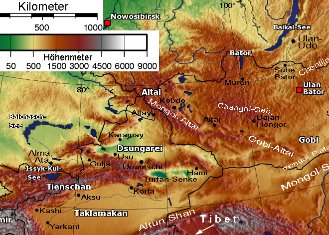
Ebi Lake ( Mongolian: Ev nuur, Middle Mongolian: Ebi; ) is a rift lake in Xinjiang Uyghur Autonomous Region in Northwestern China, near the border of Kazakhstan. Lying at the southeast end of the Dzungarian Gate, Ebi Lake is the center of the catchment of the southwestern part of the Dzungarian Basin The Junggar Basin () is one of the largest sedimentary basins in Northwest China. It is located in Xinjiang, and enclosed by the Tarbagatai Mountains of Kazakhstan in the northwest, the Altai Mountains of Mongolia in the northeast, and the Tian Sh .... The lake previously covered over 1000 km2 (400 miles2) with an average depth of less than 2 meters (6.5 feet). In August 2007, the Chinese government designated the adjoining Aibi Lake wetland as a National Nature Reserve. The high salt concentration (87 g/L) of its water prevents plants and fish from living in the actual lake, though many kinds of fish do live in the mouths of its source rivers. The lake currently covers only 500 km ... [...More Info...] [...Related Items...] OR: [Wikipedia] [Google] [Baidu] |
Bortala Mongol Autonomous Prefecture
Bortala ( mn, Бортал, Mountain:''brown steppe'', ) is an autonomous prefecture for Mongol people in the northern middle of Xinjiang Uyghur Autonomous Region, Western China. It has an area of . Bole is its capital. "Boro tala" comes from the Mongolian language and means "brown steppe". Geography Bortala is located in the southwestern part of the Dzungarian Basin. It occupies a V-shaped basin between the Dzungarian Alatau in the northwest and the Borohoro Mountains in the southwest. The prefecture borders Kazakhstan to the north and west, and has an international border of . To the east it borders Wusu City and Toli County of Tacheng Prefecture; to the south it borders Nilka County, Yining County, and Huocheng County of Ili Kazakh Autonomous Prefecture. The prefecture has two large lakes, Ebi-Nur and Sayram Lake. Administrative divisions Bortala is divided into two county-level cities, Bole and Alashankou; and two counties: Jinghe County and Wenquan County. In addition, ... [...More Info...] [...Related Items...] OR: [Wikipedia] [Google] [Baidu] |
Xinjiang
Xinjiang, SASM/GNC: ''Xinjang''; zh, c=, p=Xīnjiāng; formerly romanized as Sinkiang (, ), officially the Xinjiang Uygur Autonomous Region (XUAR), is an autonomous region of the People's Republic of China (PRC), located in the northwest of the country at the crossroads of Central Asia and East Asia. Being the largest province-level division of China by area and the 8th-largest country subdivision in the world, Xinjiang spans over and has about 25 million inhabitants. Xinjiang borders the countries of Mongolia, Russia, Kazakhstan, Kyrgyzstan, Tajikistan, Afghanistan, Pakistan and India. The rugged Karakoram, Kunlun and Tian Shan mountain ranges occupy much of Xinjiang's borders, as well as its western and southern regions. The Aksai Chin and Trans-Karakoram Tract regions, both administered by China, are claimed by India. Xinjiang also borders the Tibet Autonomous Region and the provinces of Gansu and Qinghai. The most well-known route of the historic Silk Ro ... [...More Info...] [...Related Items...] OR: [Wikipedia] [Google] [Baidu] |
China
China, officially the People's Republic of China (PRC), is a country in East Asia. It is the world's most populous country, with a population exceeding 1.4 billion, slightly ahead of India. China spans the equivalent of five time zones and borders fourteen countries by land, the most of any country in the world, tied with Russia. Covering an area of approximately , it is the world's third largest country by total land area. The country consists of 22 provinces, five autonomous regions, four municipalities, and two Special Administrative Regions (Hong Kong and Macau). The national capital is Beijing, and the most populous city and financial center is Shanghai. Modern Chinese trace their origins to a cradle of civilization in the fertile basin of the Yellow River in the North China Plain. The semi-legendary Xia dynasty in the 21st century BCE and the well-attested Shang and Zhou dynasties developed a bureaucratic political system to serve hereditary monarchies, or dyna ... [...More Info...] [...Related Items...] OR: [Wikipedia] [Google] [Baidu] |
Mongolian Language
Mongolian is the official language of Mongolia and both the most widely spoken and best-known member of the Mongolic language family. The number of speakers across all its dialects may be 5.2 million, including the vast majority of the residents of Mongolia and many of the ethnic Mongol residents of the Inner Mongolia Autonomous Region of the People's Republic of China.Estimate from Svantesson ''et al.'' (2005): 141. In Mongolia, Khalkha Mongolian is predominant, and is currently written in both Cyrillic and traditional Mongolian script. In Inner Mongolia, the language is dialectally more diverse and is written in the traditional Mongolian script. However, Mongols in both countries often use the Latin script for convenience on the Internet. In the discussion of grammar to follow, the variety of Mongolian treated is the standard written Khalkha formalized in the writing conventions and in grammar as taught in schools, but much of what is to be said is also valid for vernacular ... [...More Info...] [...Related Items...] OR: [Wikipedia] [Google] [Baidu] |
Middle Mongol Language
Middle Mongol or Middle Mongolian, was a Mongolic koiné language spoken in the Mongol Empire. Originating from Genghis Khan's home region of Northeastern Mongolia, it diversified into several Mongolic languages after the collapse of the empire. In comparison to Modern Mongolian, it is known to have had no long vowels, different vowel harmony and verbal systems and a slightly different case system. Definition and historical predecessors Middle Mongol is close to Proto-Mongolic, the ancestor language of the modern Mongolic languages, which would to set at the time when Genghis Khan united a number of tribes under his command and formed the Khamag Mongol. The term "Middle Mongol" is somewhat misleading, as what would generally by language naming rules be termed "Old Mongolian" in this terminology is actually Proto-Mongolic. The existence of another ("old") Mongol clan federation in Mongolia during the 12th century is historical, but there is no language material from this period. ... [...More Info...] [...Related Items...] OR: [Wikipedia] [Google] [Baidu] |
Rift Lake
A rift lake is a lake formed as a result of subsidence related to movement on faults within a rift zone, an area of extensional tectonics in the continental crust. They are often found within rift valleys and may be very deep. Rift lakes may be bounded by large steep cliffs along the fault margins. Examples * Lake Baikal, in Siberia * Lake Balaton, in Hungary * The Dead Sea, on the border of Israel, Palestine and Jordan, a pull-apart basin, formed along the Dead Sea Transform. * Ebi Lake in China at the Dzungarian Gate on the border with Kazakhstan * Lake Elsinore, in the Elsinore Trough in Southern California * Lake Hazar, in Turkey * Lake Idaho, a Pliocene rift lake in Idaho * Lake Khuvsgul, northern Mongolia * Limagne, an infilled Paleogene rift lake in France * Lake Lockatong, a rift lake of Triassic age, formed in the Newark Basin. * Lake Malawi, part of East African Rift * The Orcadian Basin, in northern Scotland, had rift lakes that formed during the Middle Devonian.M ... [...More Info...] [...Related Items...] OR: [Wikipedia] [Google] [Baidu] |
Kazakhstan
Kazakhstan, officially the Republic of Kazakhstan, is a transcontinental country located mainly in Central Asia and partly in Eastern Europe. It borders Russia to the north and west, China to the east, Kyrgyzstan to the southeast, Uzbekistan to the south, and Turkmenistan to the southwest, with a coastline along the Caspian Sea. Its capital is Astana, known as Nur-Sultan from 2019 to 2022. Almaty, Kazakhstan's largest city, was the country's capital until 1997. Kazakhstan is the world's largest landlocked country, the largest and northernmost Muslim-majority country by land area, and the ninth-largest country in the world. It has a population of 19 million people, and one of the lowest population densities in the world, at fewer than 6 people per square kilometre (15 people per square mile). The country dominates Central Asia economically and politically, generating 60 percent of the region's GDP, primarily through its oil and gas industry; it also has vast mineral ... [...More Info...] [...Related Items...] OR: [Wikipedia] [Google] [Baidu] |
Dzungarian Gate
The Dzungarian Gate (or Altai Gap or Altay Gap) is a geographically and historically significant mountain pass between China and Central Asia. It has been described as the "one and only gateway in the mountain-wall which stretches from Manchuria to Afghanistan, over a distance of three thousand miles []." Given its association with details in a story related by Herodotus, it has been linked to the location of legendary Hyperborea. The Dzungarian Gate (; kk, Жетісу қақпасы ''Jetısu qaqpasy'' or Жоңғар қақпасы ''Joñğar qaqpasy'') is a straight valley which penetrates the Dzungarian Alatau mountain range along the border between Kazakhstan and Xinjiang, China. It currently serves as a railway corridor between China and the west. Historically, it has been noted as a convenient pass suitable for riders on horseback between the western Eurasian steppe and lands further east, and for its fierce and almost constant winds. In his '' Histories'', Herodotu ... [...More Info...] [...Related Items...] OR: [Wikipedia] [Google] [Baidu] |
Drainage Basin
A drainage basin is an area of land where all flowing surface water converges to a single point, such as a river mouth, or flows into another body of water, such as a lake or ocean. A basin is separated from adjacent basins by a perimeter, the '' drainage divide'', made up of a succession of elevated features, such as ridges and hills. A basin may consist of smaller basins that merge at river confluences, forming a hierarchical pattern. Other terms for a drainage basin are catchment area, catchment basin, drainage area, river basin, water basin, and impluvium. In North America, they are commonly called a watershed, though in other English-speaking places, "watershed" is used only in its original sense, that of a drainage divide. In a closed drainage basin, or endorheic basin, the water converges to a single point inside the basin, known as a sink, which may be a permanent lake, a dry lake, or a point where surface water is lost underground. Drainage basins are similar ... [...More Info...] [...Related Items...] OR: [Wikipedia] [Google] [Baidu] |
Dzungarian Basin
The Junggar Basin () is one of the largest sedimentary basins in Northwest China. It is located in Xinjiang, and enclosed by the Tarbagatai Mountains of Kazakhstan in the northwest, the Altai Mountains of Mongolia in the northeast, and the Tian Shan, Heavenly Mountains (Tian Shan) in the south. The geology of Junggar Basin mainly consists of sedimentary rocks underlain by Igneous rock, igneous and Metamorphic rock, metamorphic basement rocks. The basement of the basin was largely formed during the development of the Pangaea, Pangea supercontinent during complex tectonic events from Precambrian to late Paleozoic time. The basin developed as a series of foreland basins – in other words, basins developing immediately in front of growing mountain ranges – from Permian time to the Quaternary period. The basin's preserved sedimentary records show that the climate during the Mesozoic era was marked by a transition from humid to arid conditions as monsoonal climatic effects waned. The ... [...More Info...] [...Related Items...] OR: [Wikipedia] [Google] [Baidu] |
Lakes Of China
This is a list of lakes of China. Lakes of China include: See also {{Portal, China, Geography, Lakes *List of saltwater lakes of China *Five Lakes (China) *Lake Tianchi Monster Lake Tianchi Monster is the name given to what is said to be a lake monster that lives in Heaven Lake (known as ''Cheonji'' in Korean) located in the peak of Baekdu Mountain within the Baekdudaegan and Changbai mountain ranges encompassing Jilin ... External linksHangzhou West Lake description, photo gallery and maps*https://web.archive.org/web/20030808171438/http://www.hceis.com/ChinaBasic/Lakes/Lakes%20of%20China.htm ... [...More Info...] [...Related Items...] OR: [Wikipedia] [Google] [Baidu] |


