|
East Holme
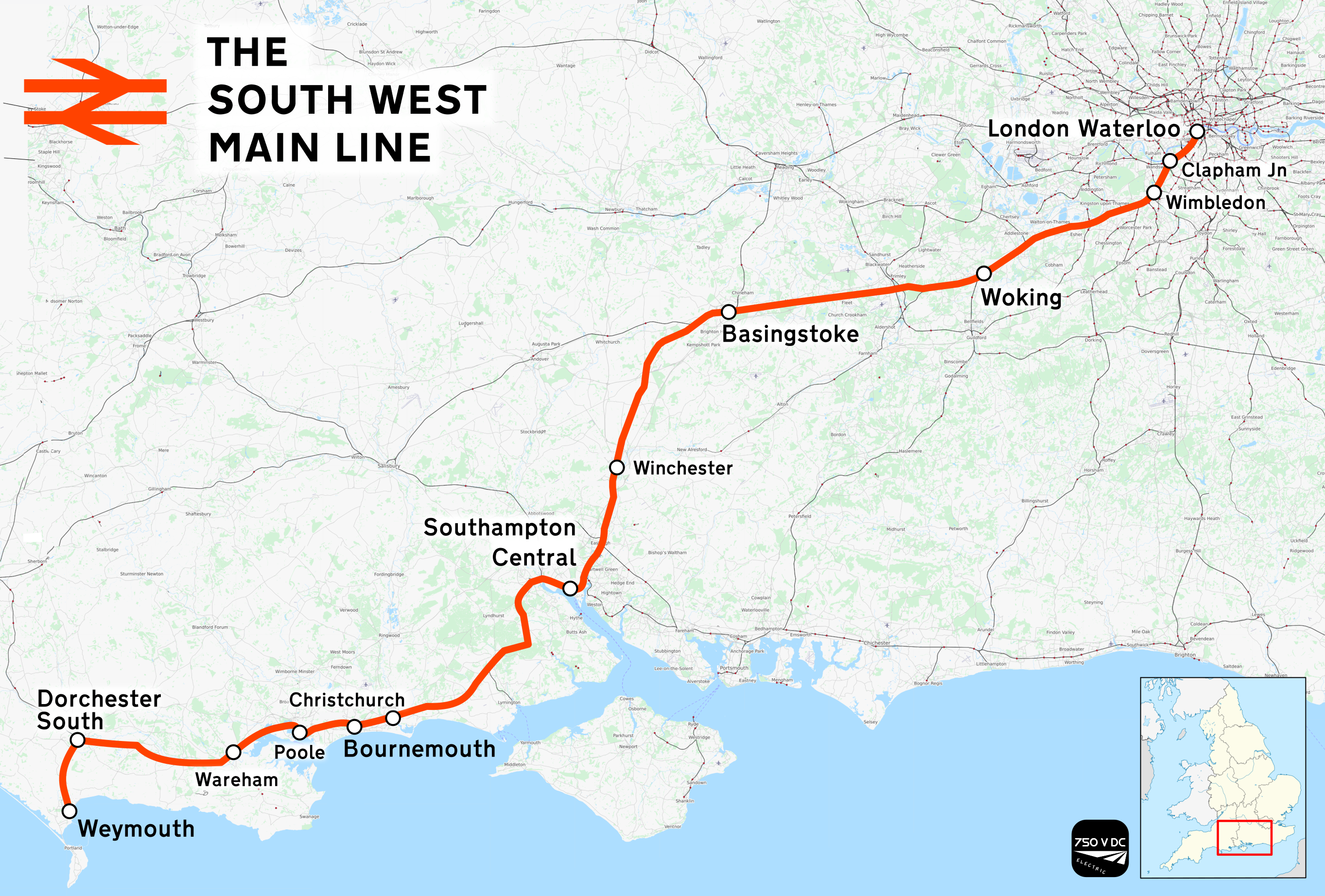
East Holme is a small village and civil parish situated about halfway between Wool and Wareham in Dorset, England. The village is sprawled around a large house called Holme Priory. In 2013 the estimated population of the civil parish was 50. The South West Main Line The South West Main Line (SWML) is a 143-mile (230 km) major railway line between Waterloo station in central London and Weymouth on the south coast of England. A predominantly passenger line, it serves many commuter areas including south we ... from London Waterloo to Weymouth runs through the village and, although the train does not stop, the village contains one of only a few of the remaining manned gate crossings. These have become particularly rare in the area. Parish church East Holme is also fortunate to contain the church of St, John the Evangelist standing rather apart from the rest of the village. The footpath across the park to the church is signposted and crosses in front of the priory, a fine late ... [...More Info...] [...Related Items...] OR: [Wikipedia] [Google] [Baidu] |
Purbeck District
Purbeck was a local government district in Dorset, England. The district was named after the Isle of Purbeck, a peninsula that forms a large proportion of the district's area. However, it extended significantly further north and west than the traditional boundary of the Isle of Purbeck which is the River Frome. The district council was based in the town of Wareham, which is itself north of the Frome. The district was formed under the Local Government Act 1972 on 1 April 1974, from the former municipal borough of Wareham, Swanage urban district and Wareham and Purbeck Rural District. The district and its council were abolished on 1 April 2019, together with the other four districts outside the greater Bournemouth area, to form a new Dorset unitary authority. Its name is recorded in 948 AD as Anglo-Saxon ''Purbicinga'', meaning "of the people of Purbic", where Purbic may be a former Celtic name, or may contain a supposed Anglo-Saxon word *''pur'' or "male lamb". Settlements :''S ... [...More Info...] [...Related Items...] OR: [Wikipedia] [Google] [Baidu] |
Dorset
Dorset ( ; archaically: Dorsetshire , ) is a county in South West England on the English Channel coast. The ceremonial county comprises the unitary authority areas of Bournemouth, Christchurch and Poole and Dorset (unitary authority), Dorset. Covering an area of , Dorset borders Devon to the west, Somerset to the north-west, Wiltshire to the north-east, and Hampshire to the east. The county town is Dorchester, Dorset, Dorchester, in the south. After the Local Government Act 1972, reorganisation of local government in 1974, the county border was extended eastward to incorporate the Hampshire towns of Bournemouth and Christchurch. Around half of the population lives in the South East Dorset conurbation, while the rest of the county is largely rural with a low population density. The county has a long history of human settlement stretching back to the Neolithic era. The Roman conquest of Britain, Romans conquered Dorset's indigenous Durotriges, Celtic tribe, and during the Ear ... [...More Info...] [...Related Items...] OR: [Wikipedia] [Google] [Baidu] |
Wareham, Dorset
Wareham ( ) is a historic market town and, under the name Wareham Town, a civil parish, in the English county of Dorset. The town is situated on the River Frome eight miles (13 km) southwest of Poole. Situation and geography The town is built on a strategic dry point between the River Frome and the River Piddle at the head of the Wareham Channel of Poole Harbour. The Frome Valley runs through an area of unresistant sand, clay and gravel rocks, and much of its valley has wide flood plains and marsh land. At its estuary the river has formed the wide shallow ria of Poole Harbour. Wareham is built on a low dry island between the marshy river plains. The town is situated on the A351 Lytchett Minster-Swanage road, linking Wareham with the A35 and A31 roads and the M27 motorway. Wareham is also the eastern terminus of the A352 road to Dorchester and Sherborne, both roads now bypassing the town centre. The town has a station on the South West Main Line railway, and was form ... [...More Info...] [...Related Items...] OR: [Wikipedia] [Google] [Baidu] |
South Dorset (constituency)
South Dorset is a constituency represented in the House of Commons of the UK Parliament since 2010 by Richard Drax, a Conservative. The constituency was created as a consequence of the Redistribution of Seats Act 1885, although the area covered has changed since then. History Formation The constituency was created as a consequence of the Redistribution of Seats Act 1885. The Act reduced the number of MPs.in Dorset from 10 to 4 (see Redistribution of Seats Act 1885#Redistributed seats: England). It was initially proposed to name the new constituencies after existing boroughs (Shaftesbury, Dorchester, Poole and Bridport) but, following an amendment in the Commons on 14 April 1885, the names were changed to the points of the compass (North Dorset, South Dorset, East Dorset, West Dorset). The South Dorset constituency was divided into 7 polling districts. Dorchester was chosen as the place where the nomination of candidates would take place and the result would be declared. Th ... [...More Info...] [...Related Items...] OR: [Wikipedia] [Google] [Baidu] |
Village
A village is a clustered human settlement or community, larger than a hamlet but smaller than a town (although the word is often used to describe both hamlets and smaller towns), with a population typically ranging from a few hundred to a few thousand. Though villages are often located in rural areas, the term urban village is also applied to certain urban neighborhoods. Villages are normally permanent, with fixed dwellings; however, transient villages can occur. Further, the dwellings of a village are fairly close to one another, not scattered broadly over the landscape, as a dispersed settlement. In the past, villages were a usual form of community for societies that practice subsistence agriculture, and also for some non-agricultural societies. In Great Britain, a hamlet earned the right to be called a village when it built a church. [...More Info...] [...Related Items...] OR: [Wikipedia] [Google] [Baidu] |
Civil Parishes In England
In England, a civil parish is a type of Parish (administrative division), administrative parish used for Local government in England, local government. It is a territorial designation which is the lowest tier of local government below districts of England, districts and metropolitan and non-metropolitan counties of England, counties, or their combined form, the Unitary authorities of England, unitary authority. Civil parishes can trace their origin to the ancient system of Parish (Church of England), ecclesiastical parishes, which historically played a role in both secular and religious administration. Civil and religious parishes were formally differentiated in the 19th century and are now entirely separate. Civil parishes in their modern form came into being through the Local Government Act 1894, which established elected Parish councils in England, parish councils to take on the secular functions of the vestry, parish vestry. A civil parish can range in size from a sparsely ... [...More Info...] [...Related Items...] OR: [Wikipedia] [Google] [Baidu] |
Wool, Dorset
Wool is a large village, civil parish and electoral ward in south Dorset, England. In the 2011 census the parish – which includes Bovington Camp army base to the north – had 2,015 households and a population of 5,310. The village lies at a historic bridging point on the River Frome, halfway between Dorchester and Wareham. Woolbridge Manor House, a 17th-century building, is a prominent feature just outside the village and the location of Tess's honeymoon in Thomas Hardy's '' Tess of the D'Urbervilles''. Other prominent features of the village include the medieval church of Holy Rood, the railway station on the South West Main Line from London Waterloo to Weymouth, and the thatched cottages along Spring Street. The place-name 'Wool' is first attested in Anglo-Saxon Writs from 1002 to 1012, where it appears as ''Wyllon''. In the Domesday Book of 1086 it appears as ''Wille'' and ''Welle'', and as ''Welles'' in 1212 in the Book of Fees. The name means 'springs' in the sense ... [...More Info...] [...Related Items...] OR: [Wikipedia] [Google] [Baidu] |
England
England is a country that is part of the United Kingdom. It shares land borders with Wales to its west and Scotland to its north. The Irish Sea lies northwest and the Celtic Sea to the southwest. It is separated from continental Europe by the North Sea to the east and the English Channel to the south. The country covers five-eighths of the island of Great Britain, which lies in the North Atlantic, and includes over 100 smaller islands, such as the Isles of Scilly and the Isle of Wight. The area now called England was first inhabited by modern humans during the Upper Paleolithic period, but takes its name from the Angles, a Germanic tribe deriving its name from the Anglia peninsula, who settled during the 5th and 6th centuries. England became a unified state in the 10th century and has had a significant cultural and legal impact on the wider world since the Age of Discovery, which began during the 15th century. The English language, the Anglican Church, and Engli ... [...More Info...] [...Related Items...] OR: [Wikipedia] [Google] [Baidu] |
South West Main Line
The South West Main Line (SWML) is a 143-mile (230 km) major railway line between Waterloo station in central London and Weymouth on the south coast of England. A predominantly passenger line, it serves many commuter areas including south western suburbs of London and the conurbations based on Southampton and Bournemouth. It runs through the counties of Surrey, Hampshire and Dorset. It forms the core of the network built by the London and South Western Railway, today mostly operated by South Western Railway. Network Rail refers to it as the South West Main Line. Operating speeds on much of the line are relatively high, with large stretches cleared for up to running. The London end of the line has as many as eight tracks plus the two Windsor Lines built separately, but this narrows to four by and continues this way until Worting Junction west of , from which point most of the line is double track. A couple of miles from the Waterloo terminus, the line runs briefly alongside ... [...More Info...] [...Related Items...] OR: [Wikipedia] [Google] [Baidu] |
Holme Priory
Holme Priory, also known as East Holne Priory, was a priory in Dorset, England. 12th century The priory of Holme, or Holne as it was anciently called, a cell of the Cluniac priory of Montacute in Somerset, was founded towards the middle of the twelfth century by Robert de Lincoln, the son of Alured de Lincoln. The founder, in his charter for the endowment of the new establishment, recites that 'moved by divine instinct to build a house of religion in honour of God' he has given to God and the church of St. Peter of Montacute and the monks serving God there his land which is called Holne, in perpetual alms for the maintenance of thirteen monks, the gift being made with the concurrence of Beuza his wife and Alured his son, by the counsel and consent of the bishop of Salisbury, in the presence of the prior and monks of Montacute, and of Gilbert the monk, 'to whom I afterwards personally gave the place,' for the souls of King Henry, of the donor's father and mother, of himself, his ... [...More Info...] [...Related Items...] OR: [Wikipedia] [Google] [Baidu] |


