|
Demographics Of South Africa
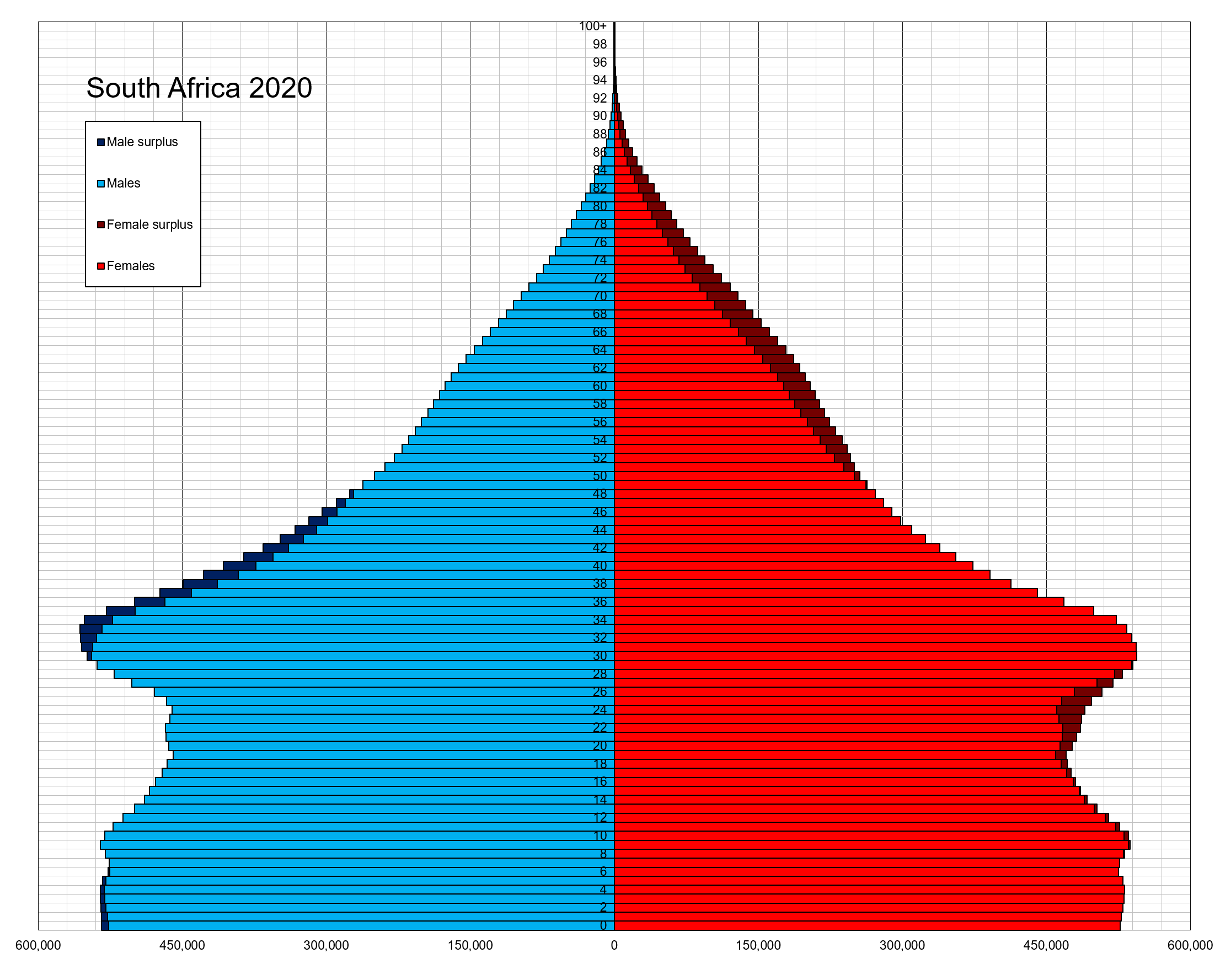
The population of South Africa is about 58.8 million people of diverse origins, cultures, languages, and religions. The South African National Census of 2022 was the most recent census held; the next will be in 2032. In 2011, Statistics South Africa counted 2.1 million foreigners in total. Reports suggest that is an underestimation. The real figure may be as high as five million, including some three million Zimbabweans. History Population Earlier Censuses, 1904 to 2011 1904 Census South African population figures for the 1904 Census.Smuts I: The Sanguine Years 1870–1919, W.K. Hancock, Cambridge University Press, 1962, pg 219 1960 Census Sources: '' Statesman's Year-Book'' 1967–1968; '' Europa Year Book'' 1969 1904-85 national census numbers Bantustan demographics were removed from South African census data during Apartheid and for this reason official figures on the national population of the country during that period will be inaccurate. 1996 Census Source: ... [...More Info...] [...Related Items...] OR: [Wikipedia] [Google] [Baidu] |
South Africa
South Africa, officially the Republic of South Africa (RSA), is the southernmost country in Africa. It is bounded to the south by of coastline that stretch along the South Atlantic and Indian Oceans; to the north by the neighbouring countries of Namibia, Botswana, and Zimbabwe; and to the east and northeast by Mozambique and Eswatini. It also completely enclaves the country Lesotho. It is the southernmost country on the mainland of the Old World, and the second-most populous country located entirely south of the equator, after Tanzania. South Africa is a biodiversity hotspot, with unique biomes, plant and animal life. With over 60 million people, the country is the world's 24th-most populous nation and covers an area of . South Africa has three capital cities, with the executive, judicial and legislative branches of government based in Pretoria, Bloemfontein, and Cape Town respectively. The largest city is Johannesburg. About 80% of the population are Black South Afri ... [...More Info...] [...Related Items...] OR: [Wikipedia] [Google] [Baidu] |
Indian South Africans
Indian South Africans are South Africans who descend from indentured labourers and free migrants who arrived from British India during the late 1800s and early 1900s. The majority live in and around the city of Durban, making it one of the largest "Indian" populated cities outside of India. As a consequence of the policies of apartheid, ''Indian'' (synonymous with ''Asian)'' is regarded as a race group in South Africa. Racial identity During the colonial era, Indians were accorded the same subordinate status in South African society as Blacks were by the white minority, which held the vast majority of political power. During the period of apartheid from 1948 to 1994, Indian South Africans were called and often voluntarily accepted, terms which ranged from "Asians" to "Indians", and were legally classified as being members of a single racial group. Some Indian South Africans believed that these terms were improvements on the negatively defined identity of "Non-White", which ... [...More Info...] [...Related Items...] OR: [Wikipedia] [Google] [Baidu] |
Eastern Cape
The Eastern Cape is one of the provinces of South Africa. Its capital is Bhisho, but its two largest cities are East London and Gqeberha. The second largest province in the country (at 168,966 km2) after Northern Cape, it was formed in 1994 out of the Xhosa homelands or bantustans of Transkei and Ciskei, together with the eastern portion of the Cape Province. The central and eastern part of the province is the traditional home of the indigenous Xhosa people. In 1820 this area which was known as the Xhosa Kingdom began to be settled by Europeans who originally came from England and some from Scotland and Ireland. Since South Africa's early years, many Xhosas believed in Africanism and figures such as Walter Rubusana believed that the rights of Xhosa people and Africans in general, could not be protected unless Africans mobilized and worked together. As a result, the Eastern Cape is home to many anti-apartheid leaders such as Robert Sobukwe, Oliver Tambo, Nelson Mandel ... [...More Info...] [...Related Items...] OR: [Wikipedia] [Google] [Baidu] |
Ciskei
Ciskei (, or ) was a Bantustan for the Xhosa people-located in the southeast of South Africa. It covered an area of , almost entirely surrounded by what was then the Cape Province, and possessed a small coastline along the shore of the Indian Ocean. Under South Africa's policy of apartheid, land was set aside for black peoples in self-governing territories. Ciskei was designated as one of two homelands, or "Bantustans", for Xhosa-speaking people. Xhosa people were forcibly resettled in the Ciskei and Transkei, the other Xhosa homeland. In contrast to the Transkei, which was largely contiguous and deeply rural, and governed by hereditary chiefs, the area that became the Ciskei had initially been made up of a patchwork of "reserves", interspersed with pockets of white-owned farms. In Ciskei, there were elected headmen and a relatively educated working-class populace, but there was a tendency of the region's black residents—who often worked in East London, Queenstown, and Kin ... [...More Info...] [...Related Items...] OR: [Wikipedia] [Google] [Baidu] |
Venda
Venda () was a Bantustan in northern South Africa, which is fairly close to the South African border with Zimbabwe to the north, while to the south and east, it shared a long border with another black homeland, Gazankulu. It is now part of the Limpopo province. Venda was founded as a homeland by the South African government for the Venda people, speakers of the Venda language.Lahiff, p. 55. The United Nations and international community refused to recognise Venda (or any other Bantustan) as an independent state. History Venda was declared self-governing on 1 February 1973,Worldstatesman.com has a chronology of Venda's transition to nominal independence and reintegration into South Africa. with |
Bophuthatswana
Bophuthatswana (, meaning "gathering of the Tswana people"), officially the Republic of Bophuthatswana ( tn, Riphaboliki ya Bophuthatswana; af, Republiek van Bophuthatswana), was a Bantustan (also known as "Homeland"; an area set aside for members of a specific ethnicity) that was declared (nominally) independent by the apartheid regime of South Africa in 1977. However, its independence, like the other Bantustans (Ciskei, Transkei and Venda) was not recognized by any country other than South Africa. Bophuthatswana was the second Bantustan to be declared an independent state, after Transkei. Its territory constituted a scattered patchwork of enclaves spread across what was then Cape Province, Orange Free State and Transvaal. Its seat of government was Mmabatho, which is now a suburb of Mahikeng. On 27 April 1994, it was reintegrated into South Africa with the coming into force of the country's interim constitution. Its territory was distributed between the new provinces of the ... [...More Info...] [...Related Items...] OR: [Wikipedia] [Google] [Baidu] |
Transkei
Transkei (, meaning ''the area beyond he riverKei''), officially the Republic of Transkei ( xh, iRiphabliki yeTranskei), was an unrecognised state in the southeastern region of South Africa from 1976 to 1994. It was, along with Ciskei, a Bantustan for the Xhosa people—and operated as a nominally independent parliamentary democracy. Its capital was Umtata (renamed Mthatha in 2004). Transkei represented a significant precedent and historic turning point in South Africa's policy of apartheid and "separate development"; it was the first of four territories to be declared independent of South Africa. Throughout its existence, it remained an internationally unrecognised, diplomatically isolated, politically unstable ''de facto'' one-party state, which at one point broke relations with South Africa, the only country that acknowledged it as a legal entity. In 1994, it was reintegrated into its larger neighbour and became part of the Eastern Cape province. History Establishment T ... [...More Info...] [...Related Items...] OR: [Wikipedia] [Google] [Baidu] |
Apartheid
Apartheid (, especially South African English: , ; , "aparthood") was a system of institutionalised racial segregation that existed in South Africa and South West Africa (now Namibia) from 1948 to the early 1990s. Apartheid was characterised by an authoritarian political culture based on ''baasskap'' (boss-hood or boss-ship), which ensured that South Africa was dominated politically, socially, and economically by the nation's minority white population. According to this system of social stratification, white citizens had the highest status, followed by Indians and Coloureds, then black Africans. The economic legacy and social effects of apartheid continue to the present day. Broadly speaking, apartheid was delineated into ''petty apartheid'', which entailed the segregation of public facilities and social events, and ''grand apartheid'', which dictated housing and employment opportunities by race. The first apartheid law was the Prohibition of Mixed Marriages ... [...More Info...] [...Related Items...] OR: [Wikipedia] [Google] [Baidu] |
Bantustan
A Bantustan (also known as Bantu homeland, black homeland, black state or simply homeland; ) was a territory that the National Party administration of South Africa set aside for black inhabitants of South Africa and South West Africa (now Namibia), as part of its policy of apartheid. By extension, outside South Africa the term refers to regions that lack any real legitimacy, consisting often of several unconnected enclaves, or which have emerged from national or international gerrymandering.Macmillan DictionaryBantustan, "1. one of the areas in South Africa where black people lived during the apartheid system; 2. SHOWING DISAPPROVAL any area where people are forced to live without full civil and political rights." The term, first used in the late 1940s, was coined from Bantu' (meaning "people" in some of the Bantu languages) and '' -stan'' (a suffix meaning "land" in the Persian language and some Persian-influenced languages of western, central, and southern Asia). It subs ... [...More Info...] [...Related Items...] OR: [Wikipedia] [Google] [Baidu] |
Orange Free State Province
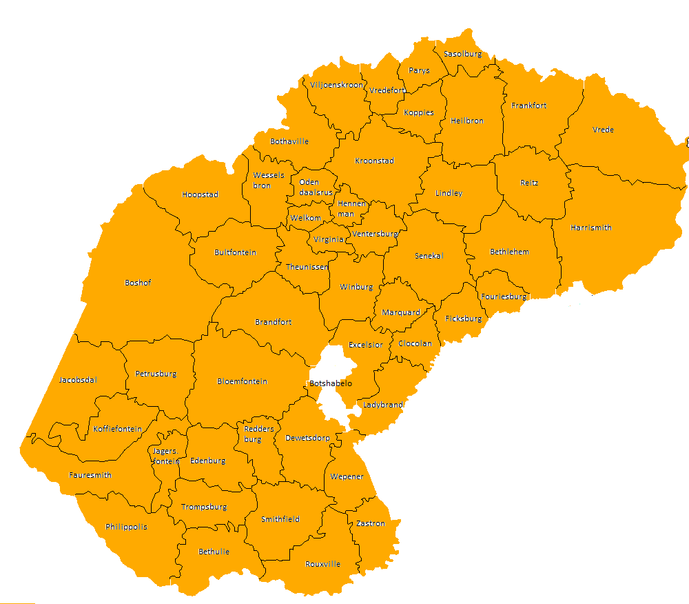
The Province of the Orange Free State ( af, Provinsie Oranje-Vrystaat), commonly referred to as the Orange Free State ( af, Oranje-Vrystaat), Free State ( af, Vrystaat) or by its abbreviation OFS, was one of the four provinces of South Africa from 1910 to 1994. After 27 April 1994 it was dissolved following the first non-racial election in South Africa. It is now called the Free State Province. Its predecessor was the Orange River Colony which in 1902 had replaced the Orange Free State, a Boer republic. Its ''outside'' borders were the same as those of the modern Free State Province; except for the bantustans ("homelands") of QwaQwa and one part of Bophuthatswana, which were contained on land ''inside'' of the provincial Orange Free State borders. Districts in 1991 Districts of the province and population at the 1991 census. * Zastron: 14,122 * Rouxville: 11,904 * Bethulie: 9,333 * Smithfield: 7,946 * Wepener: 12,964 * Dewetsdorp: 13,521 * Reddersburg: 6,070 * Edenburg: 6,96 ... [...More Info...] [...Related Items...] OR: [Wikipedia] [Google] [Baidu] |
Transvaal Province
The Province of the Transvaal ( af, Provinsie van Transvaal), commonly referred to as the Transvaal (; ), was a province of South Africa from 1910 until 1994, when a new constitution subdivided it following the end of apartheid. The name "Transvaal" refers to the province's geographical location to the north of the Vaal River. Its capital was Pretoria, which was also the country's executive capital. History In 1910, four British colonies united to form the Union of South Africa. The Transvaal Colony, which had been formed out of the bulk of the old South African Republic after the Second Boer War, became the Transvaal Province in the new union. Half a century later, in 1961, the union ceased to be part of the Commonwealth of Nations and became the Republic of South Africa. The PWV (Pretoria-Witwatersrand-Vereeniging) conurbation in the Transvaal, centred on Pretoria and Johannesburg, became South Africa's economic powerhouse, a position it still holds today as Gauteng Province ... [...More Info...] [...Related Items...] OR: [Wikipedia] [Google] [Baidu] |
Natal Province
The Province of Natal (), commonly called Natal, was a province of South Africa from May 1910 until May 1994. Its capital was Pietermaritzburg. During this period rural areas inhabited by the black African population of Natal were organized into the bantustan of KwaZulu, which was progressively separated from the province, becoming partially autonomous in 1981. Of the white population, the majority were English-speaking people of British descent, causing Natal to become the only province to vote "No" to the creation of a republic in the referendum of 1960, due to very strong monarchist, pro-British Commonwealth, and anti-secessionist sentiment. In the latter part of the 1980s, Natal was in a state of violence between the Inkatha Freedom Party and the African National Congress, with violence subsidising soon after the first non-racial election in 1994.Taylor, Rupert. "Justice denied: political violence in Kwazulu‐Natal after 1994." African Affairs 101, no. 405 (2002): 473-508. ... [...More Info...] [...Related Items...] OR: [Wikipedia] [Google] [Baidu] |


