|
Donner Party
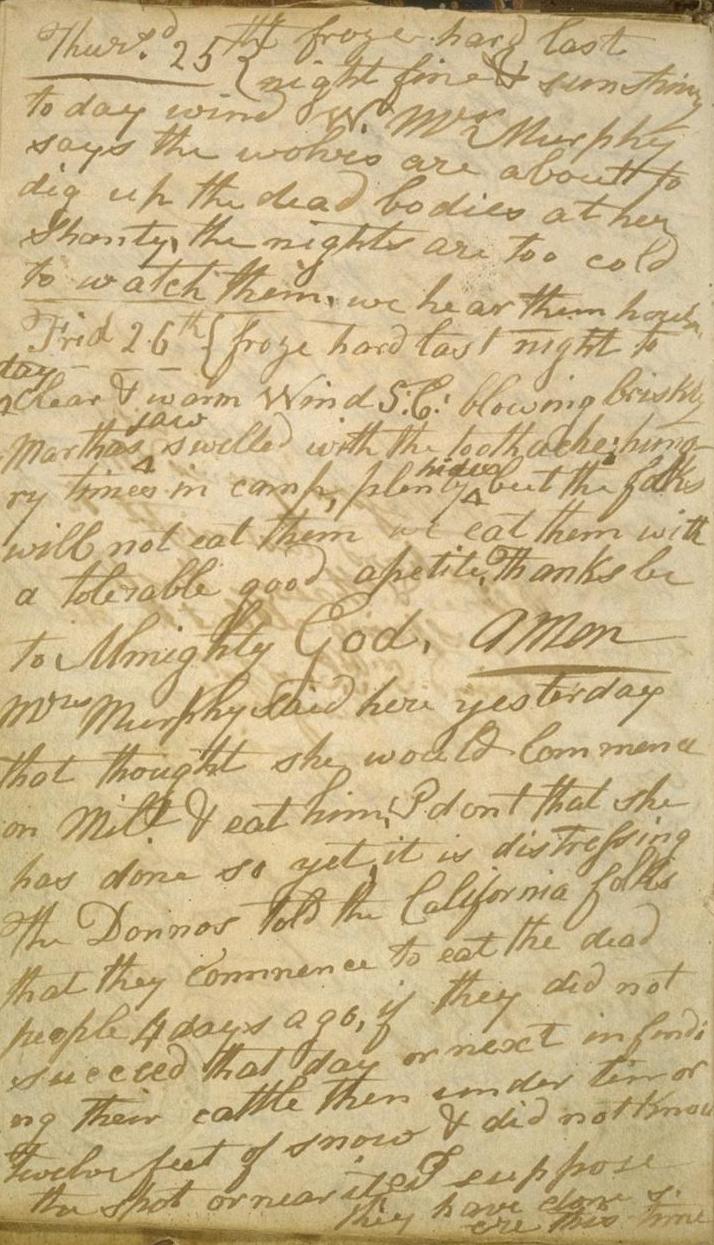
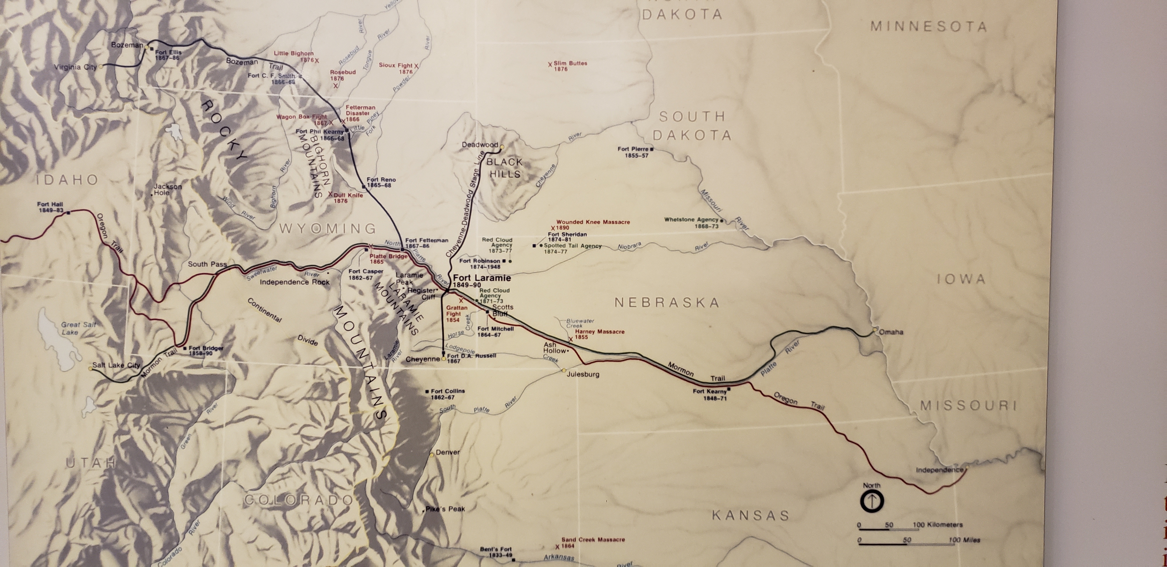
The Donner Party, sometimes called the Donner–Reed Party, was a group of American pioneers who migrated to California interim government, 1846-1850, California in a wagon train from the Midwest. Delayed by a multitude of mishaps, they spent the winter of 1846–1847 snowbound in the Sierra Nevada. Some of the migrants resorted to Human cannibalism, cannibalism to survive, mainly eating the bodies of those who had succumbed to starvation, sickness, or extreme cold, but in one case murdering and eating two Indigenous peoples of California, Native American guides. The Donner Party originated from Springfield, Illinois, and departed Independence, Missouri, on the Oregon Trail in the spring of 1846. The journey west usually took between four and six months, but the Donner Party was slowed after electing to follow a new route called the Hastings Cutoff, which bypassed established trails and instead crossed the Rocky Mountains' Wasatch Range and the Great Salt Lake Desert in present ... [...More Info...] [...Related Items...] OR: [Wikipedia] [Google] [Baidu] |
Nevada
Nevada ( ; ) is a landlocked state in the Western United States. It borders Oregon to the northwest, Idaho to the northeast, California to the west, Arizona to the southeast, and Utah to the east. Nevada is the seventh-most extensive, the 32nd-most populous, and the ninth-least densely populated U.S. state. Nearly three-quarters of Nevada's population live in Clark County, which contains the Las Vegas–Paradise metropolitan area, including three of the state's four largest incorporated cities. Nevada's capital is Carson City. Las Vegas is the largest city in the state. Nevada is officially known as the "Silver State" because of the importance of silver to its history and economy. It is also known as the "Battle Born State" because it achieved statehood during the Civil War (the words "Battle Born" also appear on its state flag); due to the presidency of Abraham Lincoln, the Union benefited immensely from the support of newly awarded statehood by the infusion of t ... [...More Info...] [...Related Items...] OR: [Wikipedia] [Google] [Baidu] |
Idaho
Idaho ( ) is a landlocked U.S. state, state in the Pacific Northwest and Mountain states, Mountain West subregions of the Western United States. It borders Montana and Wyoming to the east, Nevada and Utah to the south, and Washington (state), Washington and Oregon to the west; the state shares a small portion of the Canada–United States border to the north with the Canadian province of British Columbia. Idaho's State capital (United States), state capital and largest city is Boise, Idaho, Boise. With an area of , Idaho is the List of U.S. states and territories by area, 14th-largest state by land area. The state has a population of approximately two million people; it ranks as the List of U.S. states and territories by population, 13th-least populous and the List of U.S. states by population density, seventh-least densely populated of the List of US states, 50 U.S. states. For thousands of years, and prior to European colonization, Idaho had been inhabited by Native American ... [...More Info...] [...Related Items...] OR: [Wikipedia] [Google] [Baidu] |
Ohio
Ohio ( ) is a U.S. state, state in the Midwestern United States, Midwestern region of the United States. It borders Lake Erie to the north, Pennsylvania to the east, West Virginia to the southeast, Kentucky to the southwest, Indiana to the west, and Michigan to the northwest. Of the 50 List of states and territories of the United States, U.S. states, it is the List of U.S. states and territories by area, 34th-largest by area. With a population of nearly 11.9 million, Ohio is the List of U.S. states and territories by population, seventh-most populous and List of U.S. states and territories by population density, tenth-most densely populated state. Its List of capitals in the United States, capital and List of cities in Ohio, most populous city is Columbus, Ohio, Columbus, with the two other major Metropolitan statistical area, metropolitan centers being Cleveland and Cincinnati, alongside Dayton, Ohio, Dayton, Akron, Ohio, Akron, and Toledo, Ohio, Toledo. Ohio is nicknamed th ... [...More Info...] [...Related Items...] OR: [Wikipedia] [Google] [Baidu] |
Lansford Hastings
Lansford Warren Hastings (1819–1870) was an American explorer and Confederate soldier. He is best remembered as the developer of Hastings Cutoff, a claimed shortcut to California across what is now the state of Utah, a factor in the ill-fated Donner Party of 1846. He was a Major in the Confederate States Army during the American Civil War. Early life Born to Dr. Waitstill and Lucinda (Wood) Hastings in Mount Vernon, Ohio, he was a descendant of Thomas Hastings who came from East Anglia in England to the Massachusetts Bay Colony in 1634. Hastings was trained as a lawyer. In 1842, he traveled overland to Oregon. While there, he briefly represented Dr. John McLoughlin, preparing his land claim near Willamette Falls and surveying Oregon City, Oregon (which would become the first incorporated city west of the Rocky Mountains). He left in the spring of 1843 for Alta California, a sparsely populated province of Mexico. By the time he returned to the United States in 1844, he had d ... [...More Info...] [...Related Items...] OR: [Wikipedia] [Google] [Baidu] |
Wyoming
Wyoming ( ) is a landlocked U.S. state, state in the Mountain states, Mountain West subregion of the Western United States, Western United States. It borders Montana to the north and northwest, South Dakota and Nebraska to the east, Idaho to the west, Utah to the southwest, and Colorado to the south. With an estimated population of 587,618 as of 2024, Wyoming is the List of U.S. states and territories by population, least populous state despite being the List of U.S. states and territories by area, 10th largest by area, and it has the List of U.S. states by population density, second-lowest population density after Alaska. The List of capitals in the United States, state capital and List of municipalities in Wyoming, most populous city is Cheyenne, Wyoming, Cheyenne, which had a population of 65,132 in 2020. Wyoming's western half consists mostly of the ranges and rangelands of the Rocky Mountains; its eastern half consists of high-elevation prairie, and is referred to as th ... [...More Info...] [...Related Items...] OR: [Wikipedia] [Google] [Baidu] |
South Pass (Wyoming)
South Pass (elevation and ) is a route across the Continental Divide, in the Rocky Mountains in southwestern Wyoming. It lies in a broad high region, wide, between the nearly Wind River Range to the north and the over Oregon Buttes and arid, saline near-impassable Great Divide Basin to the south. The Pass lies in southwestern Fremont County, approximately SSW of Lander. Though it approaches a mile and a half high, South Pass is the lowest point on the Continental Divide between the Central and Southern Rocky Mountains. The passes furnish a natural crossing point of the Rockies. The historic pass became the route for emigrants on the Oregon, California, and Mormon trails to the West during the 19th century. It was designated as a U.S. National Historic Landmark on January 20, 1961. History Though well known to Native Americans, South Pass was first traversed in 1812 by European American explorers who were seeking a safer way to return from the West Coast than they had ... [...More Info...] [...Related Items...] OR: [Wikipedia] [Google] [Baidu] |
Continental Divide Of The Americas
The Continental Divide of the Americas (also known as the Great Divide, the Western Divide or simply the Continental Divide; ) is the principal, and largely mountainous, hydrological divide of the Americas. The Continental Divide extends from the Bering Strait to the Strait of Magellan, and separates the watersheds that drain into the Pacific Ocean from those river systems that drain into the Atlantic and Arctic Ocean, including those that drain into the Gulf of Mexico, the Caribbean Sea, and Hudson Bay. Although there are many other hydrological divides in the Americas, the Continental Divide is by far the most prominent of these because it tends to follow a line of high peaks along the main ranges of the Rocky Mountains and Andes, at a generally much higher elevation than the other hydrological divisions. Geography Beginning at the westernmost point of the Americas, Cape Prince of Wales, just south of the Arctic Circle, the Continental Divide's geographic path runs th ... [...More Info...] [...Related Items...] OR: [Wikipedia] [Google] [Baidu] |
Manifest Destiny
Manifest destiny was the belief in the 19th century in the United States, 19th-century United States that American pioneer, American settlers were destined to expand westward across North America, and that this belief was both obvious ("''manifest''") and certain ("''destiny''"). The belief is rooted in American exceptionalism, Romantic nationalism, and white nationalism, implying the inevitable spread of republicanism and the American way. It is one of the earliest expressions of American imperialism in the United States. According to historian William Earl Weeks, there were three basic tenets behind the concept: * The assumption of the unique moral virtue of the United States. * The assertion of its mission to redeem the world by the spread of republican government and more generally the "American way of life". * The faith in the nation's divinely ordained destiny to succeed in this mission. Manifest destiny remained heavily divisive in politics, causing constant conflict ... [...More Info...] [...Related Items...] OR: [Wikipedia] [Google] [Baidu] |
California Historical Society Quarterly
The California Historical Society (CHS) was the official historical society A historical society is non-profit organization dedicated to collecting, preserving, interpreting, and promoting the history of a particular place, group of people, or topic. They play a crucial role in promoting historical awareness and understan ... of California, until it dissolved and transferred its collections to the Stanford University Libraries in an agreement that was announced in January 2025. Founded in 1871 by a group of prominent Californian intellectuals at Santa Clara University,Leigh Irvine''A History of the New California'' 1903. the Society was designated as the California state historical society in 1979."About" California Historical Society website Although the Society was based in San Francisco, it hosted exhibits across ... [...More Info...] [...Related Items...] OR: [Wikipedia] [Google] [Baidu] |
Spanish Missions In California
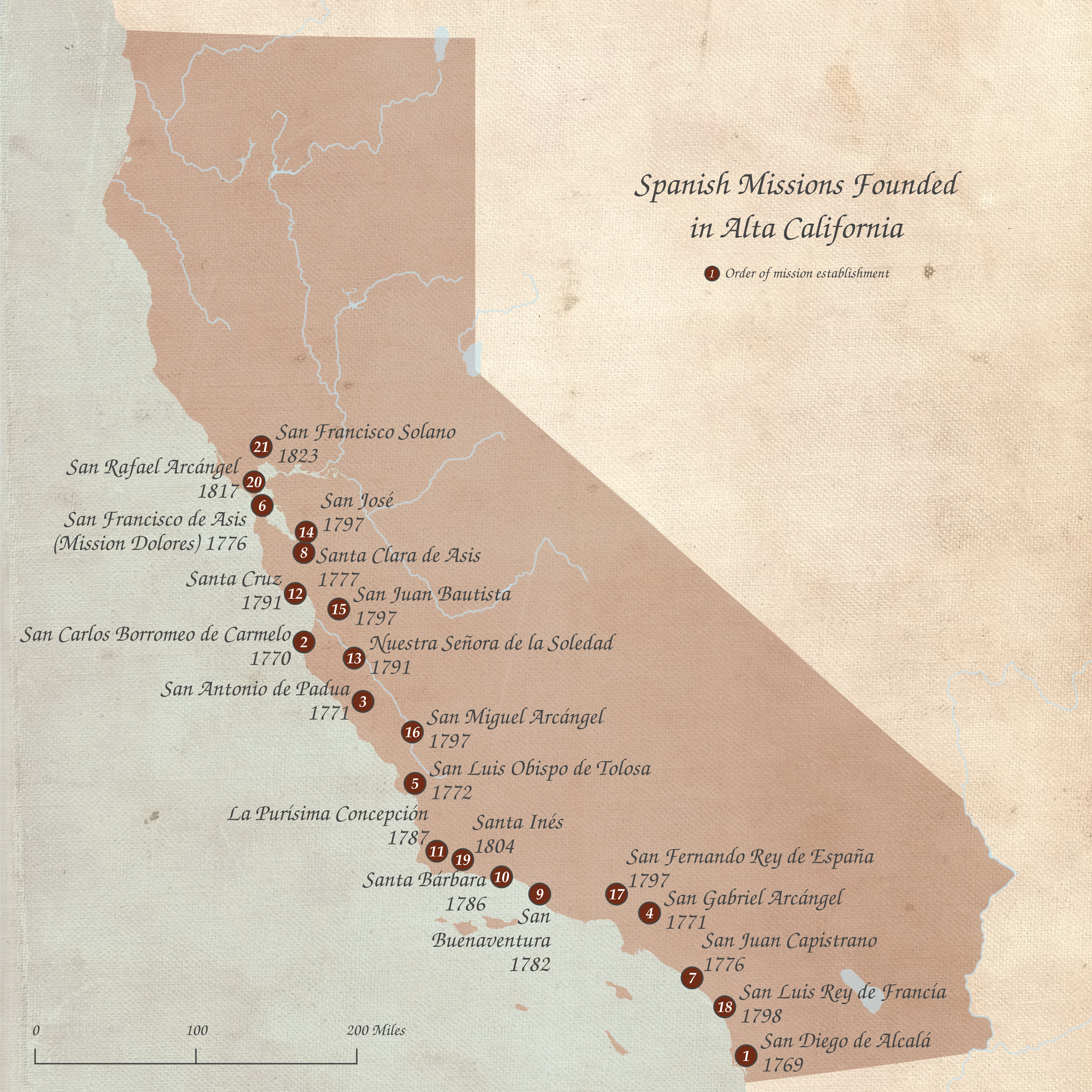
The Spanish missions in California () formed a List of Spanish missions in California, series of 21 religious outposts or missions established between 1769 and 1833 in what is now the U.S. state of California. The missions were established by Catholic priests of the Franciscan order to evangelism, evangelize Indigenous peoples of California, indigenous peoples backed by the military force of the Spanish Empire. The missions were part of the expansion and settlement of New Spain through the formation of Alta California, expanding the empire into the most northern and western parts of Spanish North America. Civilian settlers and soldiers accompanied missionaries and formed settlements like the Pueblo de Los Ángeles. Indigenous peoples of California, Indigenous peoples were forced into settlements called reductions, disrupting their traditional way of life and negatively affecting as many as one thousand villages. European diseases spread in the close quarters of the missions, ca ... [...More Info...] [...Related Items...] OR: [Wikipedia] [Google] [Baidu] |
Oregon Territory
The Territory of Oregon was an organized incorporated territory of the United States that existed from August 14, 1848, until February 14, 1859, when the southwestern portion of the territory was admitted to the United States, Union as the Oregon, State of Oregon. Originally claimed by several countries (see Oregon Country), Spanish "El Orejón" was part of the Territorio de Nutca (1789–1795), later in the 19th century, the region was divided between the British North America, British Empire and the US in 1846. When established, the territory encompassed an area that included the current states of Oregon, Washington (state), Washington, and Idaho, as well as parts of Wyoming and Montana. The capital of the territory was first Oregon City, Oregon, Oregon City, then Salem, Oregon, Salem, followed briefly by Corvallis, Oregon, Corvallis, then back to Salem, which became the state capital upon Oregon's admission to the Union. Background Originally inhabited by Native Americans, ... [...More Info...] [...Related Items...] OR: [Wikipedia] [Google] [Baidu] |


