|
Darwen Tower
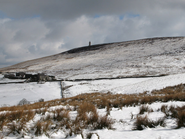
The octagonal Jubilee Tower (officially called Darwen Tower) at grid reference SD678215 on Darwen Hill overlooking the town of Darwen in Lancashire, England, was completed in 1898 to commemorate Queen Victoria's Diamond Jubilee and also to celebrate the victory of the local people for the right to access the moor. It was opened to the public on 24 September 1898. The architect was R. W. Smith-Saville and he modified the plans for the tower slightly. The tower is in height, while Darwen Hill is 1,220 feet (372 metres) above sea-level. Walkers can climb to the top of the tower via the internal staircase to see views of North Yorkshire, Morecambe Bay, Blackpool Tower, Cumbria, the Isle of Man, North Wales, Derbyshire, elsewhere in Lancashire, and surrounding moorland. Background Packmen, peddlers, farmers and labourers used tracks and moorland paths to go about their business. In the 1870s the Lord of the manor Lord of the Manor is a title that, in Anglo-Saxon England, re ... [...More Info...] [...Related Items...] OR: [Wikipedia] [Google] [Baidu] |
Moel Famau
Moel Famau is the highest hill in the Clwydian Range and the highest point (county top) of the county of Flintshire in Wales (both the historic county and the current council area). It lies on the boundary between Denbighshire and Flintshire. The hill, which also gives its name to the Moel Famau country park, has been classed as an Area of Outstanding Natural Beauty since 1985. It is also surrounded by several well-preserved Iron Age hill forts. It is not, as many people think, the highest peak in North-East Wales; this honour goes to Cadair Berwyn. It is also the third-highest peak in the extended AONB of the Clwydian Range and Dee Valley. A northern part of the Offa's Dyke long-distance footpath, one of the UK's most popular National Trails, crosses the summit of Moel Famau and the Jubilee Tower. Loggerheads Country Park is nearby. Name Although historical sources attest to a variety of spellings (such as ''Moel Famma'', ''Moel Vamma'' and ''Moel Fammau''), the only two ... [...More Info...] [...Related Items...] OR: [Wikipedia] [Google] [Baidu] |
Isle Of Man
) , anthem = "O Land of Our Birth" , image = Isle of Man by Sentinel-2.jpg , image_map = Europe-Isle_of_Man.svg , mapsize = , map_alt = Location of the Isle of Man in Europe , map_caption = Location of the Isle of Man (green) in Europe (dark grey) , subdivision_type = Sovereign state , subdivision_name = United Kingdom , established_title = Norse control , established_date = 9th century , established_title2 = Scottish control , established_date2 = 2 July 1266 , established_title3 = English control , established_date3 = 1399 , established_title4 = Revested into British Crown , established_date4 = 10 May 1765 , official_languages = , capital = Douglas , coordinates = , demonym = Manx; Manxman (plural, Manxmen); Manxwoman (plural, Manxwomen) , ethnic_groups = , ethnic_groups_year = 2021 , ethnic_groups_ref = Official census statistics provided by Statistics Isle of Man, Isle of Man Government: * * , religion = , religion_year = 2021 , relig ... [...More Info...] [...Related Items...] OR: [Wikipedia] [Google] [Baidu] |
Monuments And Memorials In Lancashire
A monument is a type of structure that was explicitly created to commemorate a person or event, or which has become relevant to a social group as a part of their remembrance of historic times or cultural heritage, due to its artistic, historical, political, technical or architectural importance. Some of the first monuments were dolmens or menhirs, megalithic constructions built for religious or funerary purposes. Examples of monuments include statues, (war) memorials, historical buildings, archaeological sites, and cultural assets. If there is a public interest in its preservation, a monument can for example be listed as a UNESCO World Heritage Site. Etymology It is believed that the origin of the word "monument" comes from the Greek ''mnemosynon'' and the Latin ''moneo'', ''monere'', which means 'to remind', 'to advise' or 'to warn', however, it is also believed that the word monument originates from an Albanian word 'mani men' which in Albanian language means 'remember ... [...More Info...] [...Related Items...] OR: [Wikipedia] [Google] [Baidu] |
West Pennine Moors
The West Pennine Moors is an area of the Pennines covering approximately of moorland and Reservoir (water), reservoirs in Lancashire and Greater Manchester, England. It is a Site of Special Scientific Interest. The West Pennine Moors are separated from the main Pennine range by the Irwell Valley to the east. The moorland includes Withnell, Anglezarke and Rivington Moors in the extreme west, Darwen and Turton Moors, Oswaldtwistle#Oswaldtwistle Moor, Oswaldtwistle Moors and Holcombe Moors. These moors are lower in height than the main spine of the South Pennines. At , the highest point is at Winter Hill (North West England), Winter Hill. The area is of historical importance with archaeological evidence of human activity from Neolithic times. The area is close to urban areas, the dramatic backdrop to Bolton, Blackburn and Bury, Greater Manchester, Bury and neighbouring towns affording panoramic views across the Lancashire Plain and the Greater Manchester conurbation. The moorland is ... [...More Info...] [...Related Items...] OR: [Wikipedia] [Google] [Baidu] |
Buildings And Structures In Blackburn With Darwen
A building, or edifice, is an enclosed structure with a roof and walls standing more or less permanently in one place, such as a house or factory (although there's also portable buildings). Buildings come in a variety of sizes, shapes, and functions, and have been adapted throughout history for a wide number of factors, from building materials available, to weather conditions, land prices, ground conditions, specific uses, prestige, and aesthetic reasons. To better understand the term ''building'' compare the list of nonbuilding structures. Buildings serve several societal needs – primarily as shelter from weather, security, living space, privacy, to store belongings, and to comfortably live and work. A building as a shelter represents a physical division of the human habitat (a place of comfort and safety) and the ''outside'' (a place that at times may be harsh and harmful). Ever since the first cave paintings, buildings have also become objects or canvasses of much artis ... [...More Info...] [...Related Items...] OR: [Wikipedia] [Google] [Baidu] |
Darwen Tower From Near Tockholes - Geograph
Darwen is a market town and civil parish in the Blackburn with Darwen borough in Lancashire, England. The residents of the town are known as "Darreners". The A666 road passes through Darwen towards Blackburn to the north, Bolton to the south and Pendlebury where it joins the A6, about north-west of Manchester. The population of Darwen stood at 28,046 in the 2011 census. The town comprises five wards and has its own town council. The town stands on the River Darwen, which flows from south to north and is visible only in the outskirts of the town, as within the town centre it runs underground. Toponym Darwen's name is Celtic in origin. In Sub Roman Britain it was within the Brythonic kingdom of Rheged, a successor to the Brigantes tribal territory. The Brythonic language name for oak is ''derw'' and this is etymologically linked to ''Derewent'' (1208), an ancient spelling for the River Darwen. Despite the area becoming part of the Anglo-Saxon Kingdom of Northumbria by the ... [...More Info...] [...Related Items...] OR: [Wikipedia] [Google] [Baidu] |
Lord Of The Manor
Lord of the Manor is a title that, in Anglo-Saxon England, referred to the landholder of a rural estate. The lord enjoyed manorial rights (the rights to establish and occupy a residence, known as the manor house and demesne) as well as seignory, the right to grant or draw benefit from the estate. The title continues in modern England and Wales as a legally recognised form of property that can be held independently of its historical rights. It may belong entirely to one person or be a moiety shared with other people. A title similar to such a lordship is known in French as ''Sieur'' or , in German, (Kaleagasi) in Turkish, in Norwegian and Swedish, in Welsh, in Dutch, and or in Italian. Types Historically a lord of the manor could either be a tenant-in-chief if he held a capital manor directly from the Crown, or a mesne lord if he was the vassal of another lord. The origins of the lordship of manors arose in the Anglo-Saxon system of manorialism. Following the N ... [...More Info...] [...Related Items...] OR: [Wikipedia] [Google] [Baidu] |
Moorland
Moorland or moor is a type of habitat found in upland areas in temperate grasslands, savannas, and shrublands and montane grasslands and shrublands biomes, characterised by low-growing vegetation on acidic soils. Moorland, nowadays, generally means uncultivated hill land (such as Dartmoor in South West England), but also includes low-lying wetlands (such as Sedgemoor, also South West England). It is closely related to heath, although experts disagree on what precisely distinguishes these types of vegetation. Generally, moor refers to highland and high rainfall zones, whereas heath refers to lowland zones which are more likely to be the result of human activity. Moorland habitats mostly occur in tropical Africa, northern and western Europe, and neotropical South America. Most of the world's moorlands are diverse ecosystems. In the extensive moorlands of the tropics, biodiversity can be extremely high. Moorland also bears a relationship to tundra (where the subsoil is permafros ... [...More Info...] [...Related Items...] OR: [Wikipedia] [Google] [Baidu] |
Derbyshire
Derbyshire ( ) is a ceremonial county in the East Midlands, England. It includes much of the Peak District National Park, the southern end of the Pennine range of hills and part of the National Forest. It borders Greater Manchester to the north-west, West Yorkshire to the north, South Yorkshire to the north-east, Nottinghamshire to the east, Leicestershire to the south-east, Staffordshire to the west and south-west and Cheshire to the west. Kinder Scout, at , is the highest point and Trent Meadows, where the River Trent leaves Derbyshire, the lowest at . The north–south River Derwent is the longest river at . In 2003, the Ordnance Survey named Church Flatts Farm at Coton in the Elms, near Swadlincote, as Britain's furthest point from the sea. Derby is a unitary authority area, but remains part of the ceremonial county. The county was a lot larger than its present coverage, it once extended to the boundaries of the City of Sheffield district in South Yorkshire where it cov ... [...More Info...] [...Related Items...] OR: [Wikipedia] [Google] [Baidu] |
North Wales
, area_land_km2 = 6,172 , postal_code_type = Postcode , postal_code = LL, CH, SY , image_map1 = Wales North Wales locator map.svg , map_caption1 = Six principal areas of Wales commonly defined to be North Wales, for policing, fire and rescue, health and regional economy. North Wales ( cy, Gogledd Cymru) is a region of Wales, encompassing its northernmost areas. It borders Mid Wales to the south, England to the east, and the Irish Sea to the north and west. The area is highly mountainous and rural, with Snowdonia National Park ( and the Clwydian Range and Dee Valley (), known for its mountains, waterfalls and trails, wholly within the region. Its population is concentrated in the north-east and northern coastal areas, with significant Welsh-speaking populations in its western and rural areas. North Wales is imprecisely defined, lacking any exact definition or administrative structure. It is commonly defined adminis ... [...More Info...] [...Related Items...] OR: [Wikipedia] [Google] [Baidu] |
Cumbria
Cumbria ( ) is a ceremonial and non-metropolitan county in North West England, bordering Scotland. The county and Cumbria County Council, its local government, came into existence in 1974 after the passage of the Local Government Act 1972. Cumbria's county town is Carlisle, in the north of the county. Other major settlements include Barrow-in-Furness, Kendal, Whitehaven and Workington. The administrative county of Cumbria consists of six districts ( Allerdale, Barrow-in-Furness, Carlisle, Copeland, Eden and South Lakeland) and, in 2019, had a population of 500,012. Cumbria is one of the most sparsely populated counties in England, with 73.4 people per km2 (190/sq mi). On 1 April 2023, the administrative county of Cumbria will be abolished and replaced with two new unitary authorities: Westmorland and Furness (Barrow-in-Furness, Eden, South Lakeland) and Cumberland ( Allerdale, Carlisle, Copeland). Cumbria is the third largest ceremonial county in England by area. It i ... [...More Info...] [...Related Items...] OR: [Wikipedia] [Google] [Baidu] |
Grit Fell
Grit Fell is a lonely hill between Clougha Pike and Ward's Stone in the Forest of Bowland in Lancashire, England. - '''', 13 June 2016 Covered by heather and large bogs, it is difficult walking country. The path from Jubilee Tower in the south is difficult and treacherous, with sheer-sided bogs deep. The path from |


