|
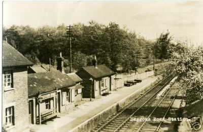
Daggons Road Railway Station
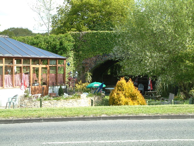
Daggons Road was a railway station serving the village of Alderholt, in Dorset, to the south west of Fordingbridge, in Hampshire. It was one of many casualties of the mass closure of British railway lines in the 1960s and 1970s; the last service was on 2 May 1964. It was on the Salisbury and Dorset Junction Railway, which ran north–south along the River Avon just to the West of the New Forest, connecting Salisbury to the North and Poole Poole () is a large coastal town and seaport in Dorset, on the south coast of England. The town is east of Dorchester and adjoins Bournemouth to the east. Since 1 April 2019, the local authority is Bournemouth, Christchurch and Poole Counc ... to the south. Today, the road through the centre of Alderholt village is still called Station Road, changing to Daggons Road at the point where the line crossed the road. A residential cul-de-sac named Station Yard (previously Daggons Road) occupies the land where the station once stood on th ... [...More Info...] [...Related Items...] OR: [Wikipedia] [Google] [Baidu] |
Daggons Road Station
Bull Hill, Dorset, Daggons and Broxhill are adjoining hamlets (mainly of Alderholt village) notable for planted woodland and tree cultivation south of Cranborne Chase and West Wiltshire Downs AONB in Dorset, England. The nearest town is Fordingbridge, about {{convert, 3, mi ENE Ene or ENE may refer to: Ene * Ene (name), a given name and surname * Ene, a type of hydrocarbon involved in the Ene reaction and the Thiol-ene reaction * -ene'', a suffix used in the names of certain organic compounds (alkenes) * Ene, Spanish .... They are primarily in the civil parish of Alderholt, though some of Bull Hill is in the parishes (secular and ecclesiastic) of Damerham in a north-west projection of Hampshire. The three places have indistinct borders as is normal for hamlets. Demography Sparesly populated, consisting demographically of almost exclusively farmhouses, roadside lines of set back cottages and smallholdings both places have many sources of and one main headwater stre ... [...More Info...] [...Related Items...] OR: [Wikipedia] [Google] [Baidu] |
River Avon, Hampshire
The River Avon () is in the south of England, rising in Wiltshire, flowing through that county's city of Salisbury and then west Hampshire, before reaching the English Channel through Christchurch Harbour in the Bournemouth, Christchurch and Poole conurbation of Dorset. It is sometimes known as the Salisbury Avon or the Hampshire Avon to distinguish it from namesakes across Great Britain. It is one of the rivers in Britain in which the phenomenon of anchor ice has been observed. The Avon is thought to contain more species of fish than any other river in Britain. Long-farmed pastures and planted, arable fields line much of the valley; an indication of the wealth these brought to landowners is in ten large listed houses with statutorily recognised and protected parks. Many prehistoric sites and broader "landscapes" are found on either side of the river, the largest being the World Heritage Site zone of Stonehenge, Avebury and Associated Sites, followed by the Old Sarum knoll for ... [...More Info...] [...Related Items...] OR: [Wikipedia] [Google] [Baidu] |
Railway Stations In Great Britain Opened In 1876
Rail transport (also known as train transport) is a means of transport that transfers passengers and goods on wheeled vehicles running on rails, which are incorporated in tracks. In contrast to road transport, where the vehicles run on a prepared flat surface, rail vehicles (rolling stock) are directionally guided by the tracks on which they run. Tracks usually consist of steel rails, installed on sleepers (ties) set in ballast, on which the rolling stock, usually fitted with metal wheels, moves. Other variations are also possible, such as "slab track", in which the rails are fastened to a concrete foundation resting on a prepared subsurface. Rolling stock in a rail transport system generally encounters lower frictional resistance than rubber-tyred road vehicles, so passenger and freight cars (carriages and wagons) can be coupled into longer trains. The operation is carried out by a railway company, providing transport between train stations or freight customer facil ... [...More Info...] [...Related Items...] OR: [Wikipedia] [Google] [Baidu] |
Former London And South Western Railway Stations
A former is an object, such as a template, gauge or cutting die, which is used to form something such as a boat's hull. Typically, a former gives shape to a structure that may have complex curvature. A former may become an integral part of the finished structure, as in an aircraft fuselage, or it may be removable, being using in the construction process and then discarded or re-used. Aircraft formers Formers are used in the construction of aircraft fuselage, of which a typical fuselage has a series from the nose to the empennage, typically perpendicular to the longitudinal axis of the aircraft. The primary purpose of formers is to establish the shape of the fuselage and reduce the column length of stringers to prevent instability. Formers are typically attached to longerons, which support the skin of the aircraft. The "former-and-longeron" technique (also called stations and stringers) was adopted from boat construction, and was typical of light aircraft built until the ad ... [...More Info...] [...Related Items...] OR: [Wikipedia] [Google] [Baidu] |
Verwood Railway Station
Verwood railway station served the town of Verwood, Dorset, England from 1866 to 1964. History The station was served by the Salisbury and Dorset Junction Railway, a line running north–south, along the River Avon just to the west of the New Forest, connecting Salisbury to the north and Wimborne to the south, meeting the Southampton and Dorchester Railway at West Moors. Unusually, the station had an inn situated in the station yard. Timeline In 1844 the Southampton & Dorchester Railway Company was formed to build a line between the two towns. The route chosen snaked (Castleman's Snake) across the New Forest from Northam to Ringwood, then via Wimborne to Hamworthy (the junction for Poole) before heading on west to Dorchester. Because of the twists and turns the line was nicknamed 'Castleman's Corkscrew' after Charles Castleman, the Wimborne solicitor who was chiefly responsible for the building of the line. This railway was opened on 1 June 1847. On 22 July 186 ... [...More Info...] [...Related Items...] OR: [Wikipedia] [Google] [Baidu] |
Fordingbridge Railway Station
Fordingbridge was a railway station serving Fordingbridge, a small town in Hampshire. It was one of many casualties of the Beeching Axe, mass closure of British railway lines in the 1960s and 1970s. The line was officially closed on 4 May 1964, but as there was no Sunday service the last trains ran on the 2nd. It was served by the Salisbury and Dorset Junction Railway, a line running north–south, along the River Avon, Hampshire, River Avon just to the west of the New Forest, connecting Salisbury to the North and Poole to the south, meeting the Southampton and Dorchester Railway at West Moors. Today, the road leading out of Fordingbridge to Sandleheath, Sandleheath village is still called Station Road; however, the spot where the station once stood is now occupied by a large mill and industrial park. Ashford Road is where the railway cottages are, the road joins onto Station Road. External linksFordingbridge Station on Subterranea Britannica Further reading * Di ... [...More Info...] [...Related Items...] OR: [Wikipedia] [Google] [Baidu] |
Poole
Poole () is a large coastal town and seaport in Dorset, on the south coast of England. The town is east of Dorchester and adjoins Bournemouth to the east. Since 1 April 2019, the local authority is Bournemouth, Christchurch and Poole Council which is a unitary authority. Poole had an estimated population of 151,500 (mid-2016 census estimates) making it the second-largest town in the ceremonial county of Dorset. Together with Bournemouth and Christchurch, the conurbation has a total population of nearly 400,000. Human settlement in the area dates back to before the Iron Age. The earliest recorded use of the town's name was in the 12th century when the town began to emerge as an important port, prospering with the introduction of the wool trade. Later, the town had important trade links with North America and, at its peak during the 18th century, it was one of the busiest ports in Britain. In the Second World War, Poole was one of the main departing points for the Normandy l ... [...More Info...] [...Related Items...] OR: [Wikipedia] [Google] [Baidu] |
Salisbury
Salisbury ( ) is a cathedral city in Wiltshire, England with a population of 41,820, at the confluence of the rivers Avon, Nadder and Bourne. The city is approximately from Southampton and from Bath. Salisbury is in the southeast of Wiltshire, near the edge of Salisbury Plain. Salisbury Cathedral was formerly north of the city at Old Sarum. The cathedral was relocated and a settlement grew up around it, which received a city charter in 1227 as . This continued to be its official name until 2009, when Salisbury City Council was established. Salisbury railway station is an interchange between the West of England Main Line and the Wessex Main Line. Stonehenge is a UNESCO World Heritage Site and is northwest of Salisbury. Name The name ''Salisbury'', which is first recorded around the year 900 as ''Searoburg'' ( dative ''Searobyrig''), is a partial translation of the Roman Celtic name ''Sorbiodūnum''. The Brittonic suffix ''-dūnon'', meaning "fortress" (in reference ... [...More Info...] [...Related Items...] OR: [Wikipedia] [Google] [Baidu] |
New Forest
The New Forest is one of the largest remaining tracts of unenclosed pasture land, heathland and forest in Southern England, covering southwest Hampshire and southeast Wiltshire. It was proclaimed a royal forest by William the Conqueror, featuring in the Domesday Book. It is the home of the New Forest Commoners, whose ancient rights of common pasture are still recognised and exercised, enforced by official verderers and agisters. In the 18th century, the New Forest became a source of timber for the Royal Navy. It remains a habitat for many rare birds and mammals. It is a biological and geological Site of Special Scientific Interest. Several areas are Geological Conservation Review and Nature Conservation Review sites. It is a Special Area of Conservation, a Ramsar site and a Special Protection Area. Copythorne Common is managed by the Hampshire and Isle of Wight Wildlife Trust, Kingston Great Common is a national nature reserve and New Forest Northern Commons is managed b ... [...More Info...] [...Related Items...] OR: [Wikipedia] [Google] [Baidu] |
Beeching Axe
The Beeching cuts (also Beeching Axe) was a plan to increase the efficiency of the nationalised railway system in Great Britain. The plan was outlined in two reports: ''The Reshaping of British Railways'' (1963) and ''The Development of the Major Railway Trunk Routes'' (1965), written by Richard Beeching and published by the British Railways Board. The first report identified 2,363 stations and of railway line for closure, amounting to 55% of stations, 30% of route miles, and 67,700 British Rail positions, with an objective of stemming the large losses being incurred during a period of increasing competition from road transport and reducing the rail subsidies necessary to keep the network running. The second report identified a small number of major routes for significant investment. The 1963 report also recommended some less well-publicised changes, including a switch to the now-standard practice of containerisation for rail freight, and the replacement of some services wit ... [...More Info...] [...Related Items...] OR: [Wikipedia] [Google] [Baidu] |
Alderholt
Alderholt is a large village and civil parish in east Dorset, England; situated west of Fordingbridge. The parish includes the hamlets of Crendell and Cripplestyle. The local travel links are located from the village to Salisbury railway station and to Bournemouth International Airport. The main road running through the village is the B3078 connecting Alderholt to Fordingbridge and Shaftesbury. The village has a population of 3,113 according to the 2001 Census, increasing along with the electoral ward of the same name to 3,171 at the 2011 Census. The village is served by a small Co-operative store, (previously a Spar, until early 2007), veterinary clinic and part-time GP surgery. The village pub iThe Churchill Arms There are three churches in the village: Alderholt Chapel, St James' Church of England, and the Tabernacle Gospel Church. Until mid-2014, Alderholt also had its own independent pet store. The village also has a large recreation ground with a sports and social clu ... [...More Info...] [...Related Items...] OR: [Wikipedia] [Google] [Baidu] |


