|
Chamoli Gopeshwar
Chamoli Gopeshwar is a township in the Garhwal hills and a municipal board within Chamoli district. It is the administrative headquarters of the Chamoli District of Uttarakhand in India. Located above sea level, it is famous for its weather (pleasant most of the year, but very cold in December and January) and its temple Chamoli Gopeshwar is known for his very beautiful temple "Gopinath" one can definitely experience the feeling of being there in Gopinath. Chamoli Gopeshwar has a very beautiful kund that is Vaitrani. Famous places in Chamoli Gopeshwar include Pt. Dindayal Park, Kunds, the Gopinath Temple, and the Telephone Tower House. The only T.B. Hospital in Chamoli District is located in Gopeshwar. A sports stadium is located on a portion of the property making up the police grounds. Major colonies are Pwd Colony, Jal Nigam, Wireless Colony, Police Colony, Kund Colony, Post Office, Basant bihar, Saraswati Bihar, Subhash Nagar, Haldapani, Negwar, Mandir Colony, Teacher Colony ... [...More Info...] [...Related Items...] OR: [Wikipedia] [Google] [Baidu] |
States And Territories Of India
India is a federal union comprising 28 states and 8 union territories, with a total of 36 entities. The states and union territories are further subdivided into districts and smaller administrative divisions. History Pre-independence The Indian subcontinent has been ruled by many different ethnic groups throughout its history, each instituting their own policies of administrative division in the region. The British Raj mostly retained the administrative structure of the preceding Mughal Empire. India was divided into provinces (also called Presidencies), directly governed by the British, and princely states, which were nominally controlled by a local prince or raja loyal to the British Empire, which held ''de facto'' sovereignty ( suzerainty) over the princely states. 1947–1950 Between 1947 and 1950 the territories of the princely states were politically integrated into the Indian union. Most were merged into existing provinces; others were organised into ... [...More Info...] [...Related Items...] OR: [Wikipedia] [Google] [Baidu] |
Gopinath Mandir
Gopinath Temple is an ancient Hindu temple dedicated to Shiva in Gopeshwar, Chamoli District, Uttarakhand, India. It is situated in Gopeshwar village now part of Gopeshwar town. The temple stands out in its architectural proficiency; it is topped by a magnificent dome and the sanctum sanctorum, which is aessible by 24 doors. The remains of broken idols found around the temple testify the existence of several more temples in ancient times. There is a trident, in the courtyard of the temple, about 5 m high, made of eight different metals, which dates back to the 12th century. It boasts the inscriptions attributed to Ashokchalla, the king of Nepal who reigned in the 13th century. Four short inscriptions written in Devanagri, which dates back to a later period, are yet to be deciphered, barring one. Legend is that the trident got fixed in this spot, when Lord Shiva threw it at Lord Kama ''Kama'' (Sanskrit ) means "desire, wish, longing" in Hindu, Buddhist, Jain, and Sikh li ... [...More Info...] [...Related Items...] OR: [Wikipedia] [Google] [Baidu] |
Shiva
Shiva (; sa, शिव, lit=The Auspicious One, Śiva ), also known as Mahadeva (; ɐɦaːd̪eːʋɐ, or Hara, is one of the principal deities of Hinduism. He is the Supreme Being in Shaivism, one of the major traditions within Hinduism. Shiva is known as "The Destroyer" within the Trimurti, the Hindu trinity which also includes Brahma and Vishnu. In the Shaivite tradition, Shiva is the Supreme Lord who creates, protects and transforms the universe. In the goddess-oriented Shakta tradition, the Supreme Goddess ( Devi) is regarded as the energy and creative power (Shakti) and the equal complementary partner of Shiva. Shiva is one of the five equivalent deities in Panchayatana puja of the Smarta tradition of Hinduism. Shiva has many aspects, benevolent as well as fearsome. In benevolent aspects, he is depicted as an omniscient Yogi who lives an ascetic life on Mount Kailash as well as a householder with his wife Parvati and his three children, Ganesha, Kartikeya and A ... [...More Info...] [...Related Items...] OR: [Wikipedia] [Google] [Baidu] |
Kedarnath
Kedarnath is a town and Nagar Panchayat in Rudraprayag district of Uttarakhand, India, known primarily for the Kedarnath Temple. It is approximately 86 kilometres from Rudraprayag, the district headquarter. Kedarnath is the most remote of the four Chota Char Dham pilgrimage sites. It is located in the Himalayas, about above sea level near the Chorabari Glacier, which is the source of the Mandakini river. The town is flanked by snow-capped peaks, most prominently the Kedarnath Mountain. The nearest road head is at Gaurikund about 16 km away. The town suffered extensive destruction during June 2013 from the Flash Floods caused by torrential rains in Uttarakhand state. Etymology The name "Kedarnath" means "the Lord of the Field". It is derived from the Sanskrit words ''kedara'' ("field") and ''natha'' ("lord"). The text ''Kashi Kedara Mahatmya'' states that it is so-called because "the crop of liberation" grows here. History Kedarnath has been a pilgrimage centre since an ... [...More Info...] [...Related Items...] OR: [Wikipedia] [Google] [Baidu] |
Badrinath
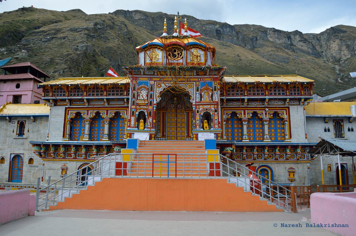
Badrinath is a town and nagar panchayat in Chamoli district in the state of Uttarakhand, India. A Hindu holy place, it is one of the four sites in India's Char Dham Hindu pilgrimage, pilgrimage and is also part of India's Chota Char Dham pilgrimage circuit. It gets its name from the Badrinath Temple. Etymology ''Badri'' refers to "Badrayana", another name for Rishi Vyasa, Ved Vyas who is believed to have resided in this region. It is also known as "Badarikashrama". History Badrinath was re-established as a major pilgrimage site by Adi Shankara in the 8th century. In earlier days, pilgrims used to walk hundreds of miles to visit the Badrinath temple. The temple has been repeatedly destroyed by earthquakes and avalanches. As late as the First World War, the town consisted only of the 20-odd huts used by the temple's staff, but the site drew thousands each year and up to 50,000 on its wikt:duodecennial, duodecennial festivals (every twelve years). In recent years its populari ... [...More Info...] [...Related Items...] OR: [Wikipedia] [Google] [Baidu] |
Rudranath
Rudranath ( sa, रुद्रनाथ) is a Hindu temple dedicated to God Shiva, located in the Garhwal Himalayan mountains in Uttarakhand, India. Located at above sea level, this natural rock temple is situated within a dense forest of rhododendron dwarfs and Alpine pastures. The temple is the third temple to be visited in the Panch Kedar pilgrimage circuit, comprising five Shiva temples in the Garhwal region to be visited in a strict pecking order starting with Kedarnath (Sanskrit: केदारनाथ) at an altitude of 3,583 m (11,755 ft), the Tungnath (तुंगनाथ)(3,680 m or 12,070 ft), Rudranath (रुद्रनाथ) (3,550 m or 11,500 ft), Madhyamaheshwar (मध्यमहेश्वर) (3,490 m or 11,450 ft) and Kalpeshwar (कल्पेश्वर) (2,200 m or 7,200 ft). The face (''mukha'') of god Shiva is worshipped as "Neelakantha Mahadeva" here. The trek starts from Sagar Village which is approximately 3 km away from Gopeshwar. The ... [...More Info...] [...Related Items...] OR: [Wikipedia] [Google] [Baidu] |
Anusuya Devi Temple
Anasuya () is an ascetic, and the wife of Sage Atri in Hinduism. She is the daughter of Devahuti and Sage Kardama in Hindu texts. In the ''Ramayana'', she lives with her husband in a small hermitage on the southern border of the Chitrakuta forest. A pious woman who leads an austere life, she is described as having miraculous powers. Anasuya is the sister of the sage Kapila, who also served as her teacher. She is extolled as ''Sati Anasuya'' (Ascetic Anasuya) and ''Mata Anasuya'' (Mother Anasuya), the chaste wife of Sage Atri. She becomes the mother of Dattatreya, the sage-avatar of Vishnu, Chandra, a form of Brahma, and Durvasa, the irascible sage avatar of Shiva. When Sita and Rama visit her during their exile, Anasuya is very attentive to them, giving the former an unguent that would maintain her beauty forever. Etymology Anasuya is composed of two Sanskrit words: ''ana'' and ''asūya,'' translating to the 'one who is free from jealousy or envy'''. Legend Origin The gene ... [...More Info...] [...Related Items...] OR: [Wikipedia] [Google] [Baidu] |
Tungnath
Tungnath ( IAST:tuņgnāth) is one of the highest Shiva temples in the world and is the highest of the five Panch Kedar temples located in the Rudraprayag district, in the Indian state of Uttarakhand. The Tungnath (literal meaning: Lord of the peaks) mountains form the Mandakini and Alaknanda river valleys. It is located at an altitude of , and just below the peak of Chandrashila. It has a rich legend linked to the Pandavas, heroes of the Mahabharata epic. Legend According to Hindu mythology, Shiva and his consort, Parvati both reside in the Himalayas: Shiva resides at Mount Kailash. Parvati is also called Shailaputri, which means 'Daughter of the Mountain'. Many folk legends related to the Garhwal region, Shiva and the creation of the Panch Kedar temples are narrated. A folk legend about Panch Kedar relates to the Pandavas, the heroes of the Hindu epic Mahabharata. The Pandavas defeated and slayed their cousins — the Kauravas in the epic Kurukshetra war. They wished t ... [...More Info...] [...Related Items...] OR: [Wikipedia] [Google] [Baidu] |
Census
A census is the procedure of systematically acquiring, recording and calculating information about the members of a given population. This term is used mostly in connection with national population and housing censuses; other common censuses include censuses of agriculture, traditional culture, business, supplies, and traffic censuses. The United Nations (UN) defines the essential features of population and housing censuses as "individual enumeration, universality within a defined territory, simultaneity and defined periodicity", and recommends that population censuses be taken at least every ten years. UN recommendations also cover census topics to be collected, official definitions, classifications and other useful information to co-ordinate international practices. The UN's Food and Agriculture Organization (FAO), in turn, defines the census of agriculture as "a statistical operation for collecting, processing and disseminating data on the structure of agriculture, covering th ... [...More Info...] [...Related Items...] OR: [Wikipedia] [Google] [Baidu] |
Humid Subtropical Climate
A humid subtropical climate is a zone of climate characterized by hot and humid summers, and cool to mild winters. These climates normally lie on the southeast side of all continents (except Antarctica), generally between latitudes 25° and 40° and are located poleward from adjacent tropical climates. It is also known as warm temperate climate in some climate classifications. Under the Köppen climate classification, ''Cfa'' and ''Cwa'' climates are either described as humid subtropical climates or warm temperate climates. This climate features mean temperature in the coldest month between (or ) and and mean temperature in the warmest month or higher. However, while some climatologists have opted to describe this climate type as a "humid subtropical climate", Köppen himself never used this term. The humid subtropical climate classification was officially created under the Trewartha climate classification. In this classification, climates are termed humid subtropical when the ... [...More Info...] [...Related Items...] OR: [Wikipedia] [Google] [Baidu] |
National Highway 58 (India, Old Numbering)
This article is about the old number of Delhi-Meerut-Roorkee-Haridwar-Badrinath National Highway. National Highway 58 (NH 58) was a national highway in India before it was renumbered. It linked Ghaziabad in Uttar Pradesh near New Delhi with Badrinath and Mana Pass in Uttarakhand near Indo-Tibet border. The highway started from Mana village north of Badrinath temple and passed through Badrinath, Joshimath, Chamoli, Vishnuprayag, Nandaprayag, Karnaprayag, Rudraprayag, Srinagar, Devprayag, Rishikesh, Haridwar, Roorkee, Muzaffarnagar, Meerut and Modinagar and ended at Ghaziabad, a few km short of Delhi. Of its total length of 538 km, NH 58 traversed 165 km in Uttar Pradesh and 373 km in Uttarakhand. The highway was constructed and maintained by National Highways Authority of India from Delhi to Rishikesh and Border Roads Organisation (BRO) of Indian Army from Rishikesh, where the plains end and the mountains start, to its northernmost end. The highway bypasses Mee ... [...More Info...] [...Related Items...] OR: [Wikipedia] [Google] [Baidu] |


