|
Cyclone Tino
Severe Tropical Cyclone Tino was a tropical cyclone which itself and an associated convergence zone caused significant damage across ten island nations in the South Pacific Ocean during January 2020. First noted as a tropical disturbance during January 11, to the southwest of Honiara in the Solomon Islands, the system gradually developed over the next few days as it moved eastwards in between the Solomon Islands and Vanuatu prior to being named Tino as it approached Fiji during January 16. Continuing to track south-eastward, Tino continued strengthening as it passed near Fiji, bringing copious amounts of rainfall to the area. Whilst losing latitude, the system continued to strengthen and peaked as a category 3 tropical cyclone on January 17, with signs of an eye forming. Shortly after peak intensity, Tino was impacted by high wind shear and decreasing sea surface temperatures, triggering a weakening trend. Tino moved out of the tropics shortly thereafter and became an extr ... [...More Info...] [...Related Items...] OR: [Wikipedia] [Google] [Baidu] |
Solomon Islands
Solomon Islands is an island country consisting of six major islands and over 900 smaller islands in Oceania, to the east of Papua New Guinea and north-west of Vanuatu. It has a land area of , and a population of approx. 700,000. Its capital, Honiara, is located on the largest island, Guadalcanal. The country takes its name from the wider area of the Solomon Islands (archipelago), which is a collection of Melanesian islands that also includes the Autonomous Region of Bougainville (currently a part of Papua New Guinea), but excludes the Santa Cruz Islands. The islands have been settled since at least some time between 30,000 and 28,800 BCE, with later waves of migrants, notably the Lapita people, mixing and producing the modern indigenous Solomon Islanders population. In 1568, the Spanish navigator Álvaro de Mendaña was the first European to visit them. Though not named by Mendaña, it is believed that the islands were called ''"the Solomons"'' by those who later receiv ... [...More Info...] [...Related Items...] OR: [Wikipedia] [Google] [Baidu] |
Oinafa
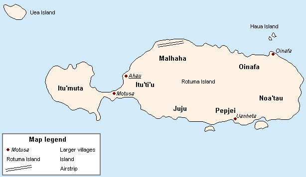
Oinafa is one of the seven districts on the island of in Rotuma, a dependency of Fiji Fiji ( , ,; fj, Viti, ; Fiji Hindi: फ़िजी, ''Fijī''), officially the Republic of Fiji, is an island country in Melanesia, part of Oceania in the South Pacific Ocean. It lies about north-northeast of New Zealand. Fiji consists .... It includes the villages of Oinafa, Lopta, and Paptea. References Districts of Rotuma {{Fiji-geo-stub ... [...More Info...] [...Related Items...] OR: [Wikipedia] [Google] [Baidu] |
Tropical Cyclone Formation Alert
A Tropical Cyclone Formation Alert (TCFA) is a bulletin released by the U.S. Navy-operated Joint Typhoon Warning Center in Honolulu, Hawaii or the Fleet Weather Center in Norfolk, Virginia, warning of the possibility of a tropical cyclone forming from a tropical disturbance that has been monitored. Such alerts are generally always issued when it is fairly certain that a tropical cyclone will form and are not always released before cyclone genesis, particularly if the cyclone appears suddenly. The TCFA consists of several different checks that are performed by the on-duty meteorologist of the system and its surroundings. If the condition being checked is met, a certain number of points are given to the system. Parts of the TCFA Section 1 The first section of the TCFA contains information on the area of the alert as well as the estimated center of the circulation. The estimated maximum sustained winds are provided as well. Section 2 The second section generally contains more specif ... [...More Info...] [...Related Items...] OR: [Wikipedia] [Google] [Baidu] |
Joint Typhoon Warning Center
The Joint typhoon Warning Center (JTWC) is a joint United States Navy – United States Air Force command in Pearl Harbor, Hawaii. The JTWC is responsible for the issuing of tropical cyclone warnings in the North-West Pacific Ocean, South Pacific Ocean, and Indian Ocean for all branches of the U.S. Department of Defense and other U.S. government agencies. Their warnings are intended for the protection of primarily military ships and aircraft as well as military installations jointly operated with other countries around the world. Its U.S. Navy components are aligned with the Naval Meteorology and Oceanography Command. History The origins of the Joint Typhoon Warning Center (JTWC) can be traced back to June 1945, when the Fleet Weather Center/Typhoon Tracking Center was established on the island of Guam, after multiple typhoons, including Typhoon Cobra of December 1944 and Typhoon Connie in June 1945, had caused a significant loss of men and ships. At this time the center ... [...More Info...] [...Related Items...] OR: [Wikipedia] [Google] [Baidu] |
Port Vila
Port Vila (french: Port-Vila), or simply Vila (; french: Vila; bi, Vila ), is the capital and largest city of Vanuatu. It is located on the island of Efate. Its population in the last census (2009) was 44,040, an increase of 35% on the previous census result (29,356 in 1999). In 2009, the population of Port Vila formed 18.8% of the country's population, and 66.9% of the population of Efate. On the south coast of the island of Efate, in Shefa Province, Port Vila is the economic and commercial centre of Vanuatu. The mayor is Erick Puyo Festa, of the Vanua'aku Pati, elected in January 2018; his deputy is Jenny Regenvanu, of the Graun mo Jastis Pati. On 13 March 2015, Port Vila bore extensive damage from Cyclone Pam. Name Locally the town is most commonly referred to simply as "Vila", whether in French or Bislama or in English (not like English "villa"). The name of the area is ''Efil'' in the native South Efate language and ''Ifira'' in neighbouring Mele-Fila languag ... [...More Info...] [...Related Items...] OR: [Wikipedia] [Google] [Baidu] |
Temotu Province
Temotu (or Te Motu, literally "the island" in Polynesian) is the easternmost province of Solomon Islands. The province was formerly known as Santa Cruz Islands Province. It consists, essentially, of two chains of islands which run parallel to each other from the northwest to the southeast. Its area is . Administrative divisions Temotu Province is sub-divided into the following wards: Temotu Province (pop 21,362) * Reef Islands ** Polynesian Outer Islands (353) ** Fenualoa (1,305) ** Nipua/Nopoli (880) ** Lipe/Temua (796) ** Manuopo (1,030) ** Nenumpo (1,163) * Santa Cruz Islands ** Graciosa Bay (1,264) ** North East Santa Cruz (1,843) ** Nanggu/Lord Howe (1,863) ** Nea/Noole (1,770) ** Nevenema (947) ** Luva Station (2,335) ** Neo (1,558) * isolated islands and groups ** Duff Islands (509) ** Utupua (1,168) ** Vanikoro (1,293) ** Tikopia (1,285) Islands The islands or island groups which make up the province are: * Anuta * Duff Islands (including Taumako) * Fatutaka ... [...More Info...] [...Related Items...] OR: [Wikipedia] [Google] [Baidu] |
Eye (cyclone)
The eye is a region of mostly calm weather at the center of tropical cyclones. The eye of a storm is a roughly circular area, typically in diameter. It is surrounded by the ''eyewall'', a ring of towering thunderstorms where the most severe weather and highest winds occur. The cyclone's lowest barometric pressure occurs in the eye and can be as much as 15 percent lower than the pressure outside the storm. In strong tropical cyclones, the eye is characterized by light winds and clear skies, surrounded on all sides by a towering, symmetric eyewall. In weaker tropical cyclones, the eye is less well defined and can be covered by the central dense overcast, an area of high, thick clouds that show up brightly on satellite imagery. Weaker or disorganized storms may also feature an eyewall that does not completely encircle the eye or have an eye that features heavy rain. In all storms, however, the eye is the location of the storm's minimum barometric pressure—where the atmospheric pr ... [...More Info...] [...Related Items...] OR: [Wikipedia] [Google] [Baidu] |
Atmospheric Convection
Atmospheric convection is the result of a parcel-environment instability, or temperature difference layer in the atmosphere. Different lapse rates within dry and moist air masses lead to instability. Mixing of air during the day which expands the height of the planetary boundary layer leads to increased winds, cumulus cloud development, and decreased surface dew points. Moist convection leads to thunderstorm development, which is often responsible for severe weather throughout the world. Special threats from thunderstorms include hail, downbursts, and tornadoes. Overview There are a few general archetypes of atmospheric instability that are used to explain convection (or lack thereof). A necessary (but not sufficient) condition for convection is that the environmental lapse rate (the rate of decrease of temperature with height) is steeper than the lapse rate experienced by a rising parcel of air. When this condition is met, upward-displaced air parcels can become buoyant and th ... [...More Info...] [...Related Items...] OR: [Wikipedia] [Google] [Baidu] |
Fiji Meteorological Service
The Fiji Meteorological Service (FMS) is a Department of the government of Fiji responsible for providing weather forecasts and is based on the grounds of Nadi Airport in Nadi. The current director of Fiji Meteorological Service is Misaeli Funaki. Since 1985, FMS has been responsible for naming and tracking tropical cyclones in the Southwest Pacific region. Current Meteorologists working at FMS have a Graduate Diploma in Meteorology from the Australian Bureau of Meteorology. History Before World War II, weather observations in Fiji were the responsibility of the harbour board and limited to recording various meteorological details at various locations around the island nation. During the 1939 Defence Conference in Wellington, New Zealand, Fiji's capital Suva was identified as the location of an upgraded meteorological service for the Pacific region. As a result, a facility was established at Laucala Bay during 1940, before it was expanded during the following year to support the o ... [...More Info...] [...Related Items...] OR: [Wikipedia] [Google] [Baidu] |
Samoa
Samoa, officially the Independent State of Samoa; sm, Sāmoa, and until 1997 known as Western Samoa, is a Polynesian island country consisting of two main islands (Savai'i and Upolu); two smaller, inhabited islands (Manono Island, Manono and Apolima); and several smaller, uninhabited islands, including the Aleipata Islands (Nu'utele, Nu'ulua, Fanuatapu and Namua). Samoa is located west of American Samoa, northeast of Tonga (closest foreign country), northeast of Fiji, east of Wallis and Futuna, southeast of Tuvalu, south of Tokelau, southwest of Hawaii, and northwest of Niue. The capital city is Apia. The Lapita culture, Lapita people discovered and settled the Samoan Islands around 3,500 years ago. They developed a Samoan language and Samoan culture, Samoan cultural identity. Samoa is a Unitary state, unitary Parliamentary system, parliamentary democracy with 11 Administrative divisions of Samoa, administrative divisions. It is a sovereign state and a member of the ... [...More Info...] [...Related Items...] OR: [Wikipedia] [Google] [Baidu] |
Niue
Niue (, ; niu, Niuē) is an island country in the South Pacific Ocean, northeast of New Zealand. Niue's land area is about and its population, predominantly Polynesian, was about 1,600 in 2016. Niue is located in a triangle between Tonga, Samoa, and the Cook Islands. It is 604 kilometres northeast of Tonga. The island is commonly referred to as "The Rock", which comes from the traditional name "Rock of Polynesia". Niue is one of the world's largest coral islands. The terrain of the island has two noticeable levels. The higher level is made up of a limestone cliff running along the coast, with a plateau in the centre of the island reaching approximately 60 metres (200 feet) above sea level. The lower level is a coastal terrace approximately 0.5 km (0.3 miles) wide and about 25–27 metres (80–90 feet) high, which slopes down and meets the sea in small cliffs. A coral reef surrounds the island, with the only major break in the reef being in the central western c ... [...More Info...] [...Related Items...] OR: [Wikipedia] [Google] [Baidu] |


