|
Coburg
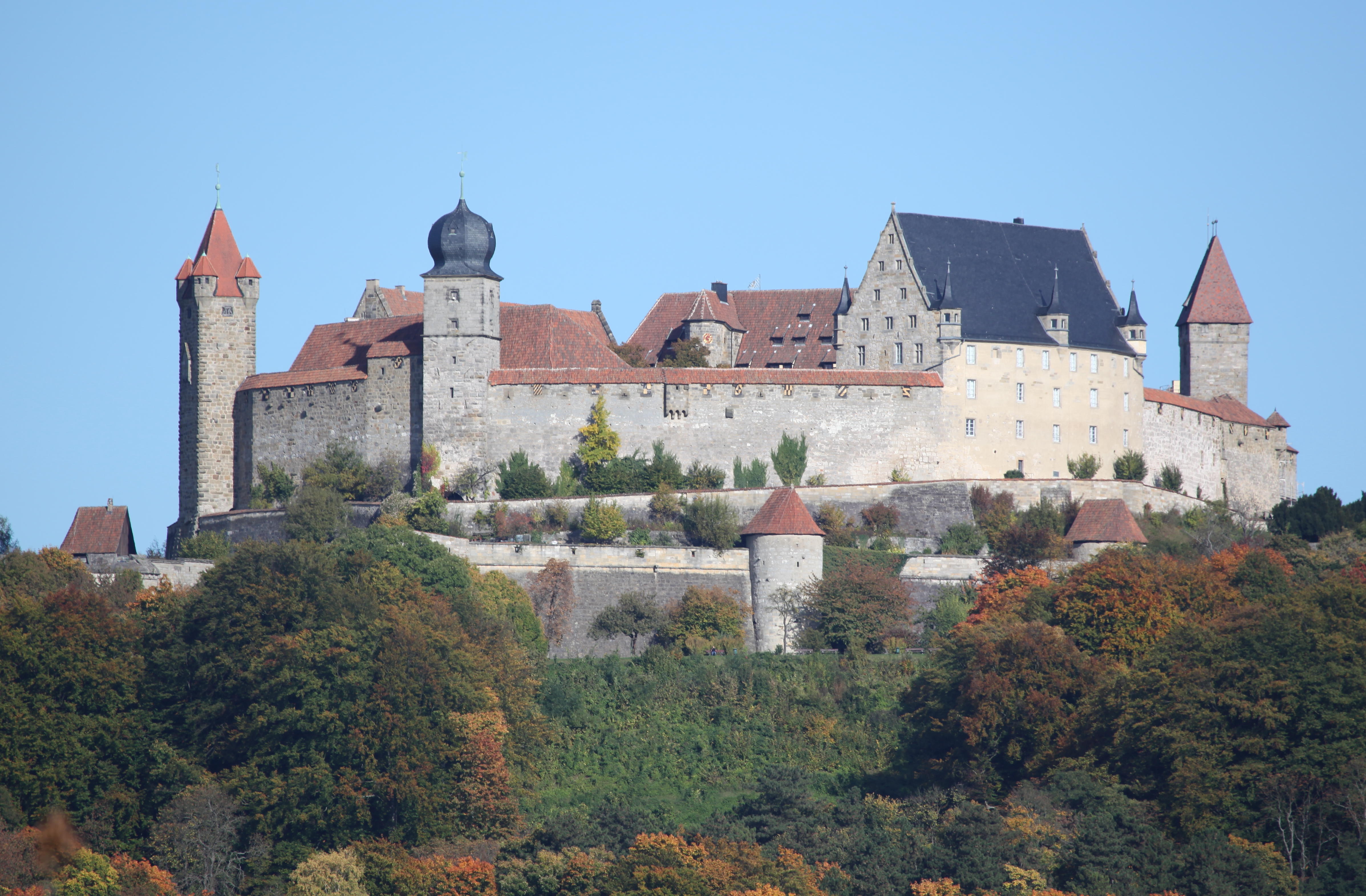
Coburg ( , ) is a Town#Germany, town located on the Itz (river), Itz river in the Upper Franconia region of Bavaria, Germany. Long part of one of the Thuringian states of the Ernestine duchies, Wettin line, it joined Bavaria by popular vote only in 1920. Until the revolution of 1918, it was one of the capitals of the Saxe-Coburg and Gotha, Duchy of Saxe-Coburg and Gotha and the Duchy of Saxe-Coburg-Saalfeld. Through successful dynastic policies, the ruling princely family married into several of the royal families of Europe, most notably in the person of Prince Albert of Saxe-Coburg and Gotha, Prince Albert, who married Queen Victoria in 1840. As a result of these close links with the royal houses of Europe in the late 19th and early 20th centuries, Coburg was frequently visited by the crowned heads of Europe and their families. Coburg is the location of Veste Coburg, one of Germany's largest castles. Today, Coburg's population is close to 41,500. Since it was little damaged in ... [...More Info...] [...Related Items...] OR: [Wikipedia] [Google] [Baidu] |
Saxe-Coburg And Gotha
Saxe-Coburg and Gotha (), or Saxe-Coburg-Gotha ( ), was an Ernestine duchy in Thuringia ruled by a branch of the House of Wettin, consisting of territories in the present-day states of Thuringia and Bavaria in Germany. It lasted from 1826 to 1918. In November 1918, Charles Edward, Duke of Saxe-Coburg and Gotha, was forced to abdicate. In 1920, the northern part of the duchy (since 1918 the Free State of Gotha; culturally and linguistically Thuringian) was merged with six other Thuringian free states to form the Free State of Thuringia: Saxe-Weimar-Eisenach (until 1918 a grand duchy), Saxe-Altenburg and Saxe-Meiningen (until 1918 duchies), Schwarzburg-Rudolstadt and Schwarzburg-Sondershausen (until 1918 principalities), as well as the People's State of Reuss (until 1918 the principalities of Reuss-Gera and Reuss-Greiz). The southern part of the duchy (since 1918 the Free State of Coburg; culturally and linguistically Franconian), as southernmost of the Thuringian st ... [...More Info...] [...Related Items...] OR: [Wikipedia] [Google] [Baidu] |
Duchy Of Saxe-Coburg-Saalfeld
Saxe-Coburg-Saalfeld () was one of the Saxon Duchies held by the Ernestine line of the House of Wettin. Established in 1699, the Saxe-Coburg-Saalfield line lasted until the reshuffle of the Ernestine territories that occurred following the extinction of the Saxe-Gotha line in 1825, in which the Saxe-Coburg-Saalfeld line received Gotha, but lost Saalfeld to Saxe-Meiningen. Saxe-Saalfeld 1680 to 1735 After the Duke of Saxe-Gotha, Ernest the Pious, died on 26 March 1675 in Gotha, the Principality was divided on 24 February 1680 among his seven surviving sons. The lands of Saxe-Saalfeld went to the youngest of them, who became John Ernest IV (1658–1729), the Duke of Saxe-Saalfeld. But the new Principality did not have complete independence. It had to depend on the higher authorities in Gotha for the matters of administration of its three districts, Saalfeld, Grafenthal and Probstzella – the so-called "''Nexus Gothanus''" – because that was the residence of John Ernest's o ... [...More Info...] [...Related Items...] OR: [Wikipedia] [Google] [Baidu] |
Prince Albert Of Saxe-Coburg And Gotha
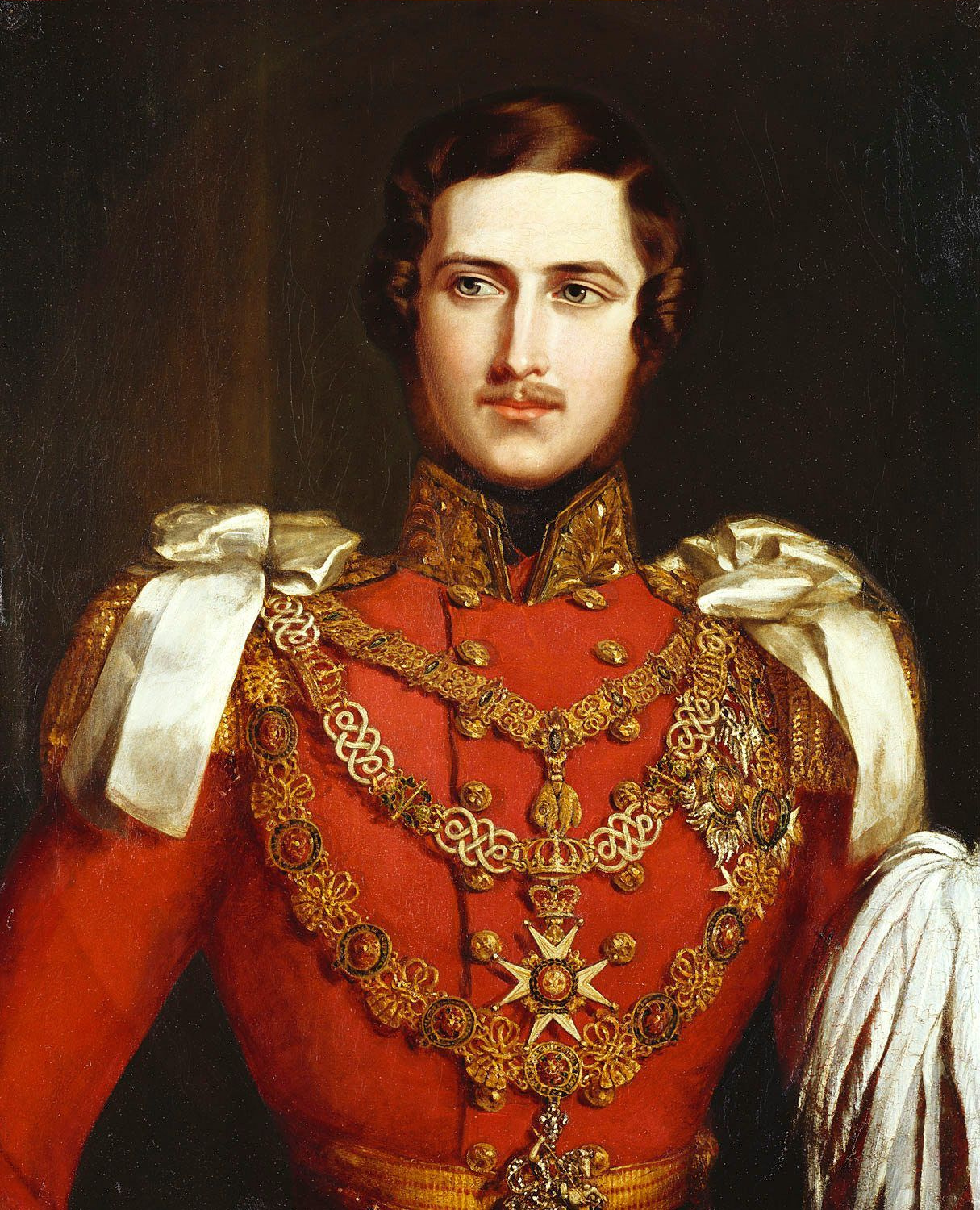
Prince Albert of Saxe-Coburg and Gotha (Franz August Karl Albert Emanuel; 26 August 1819 – 14 December 1861) was the husband of Queen Victoria. As such, he was consort of the British monarch from Wedding of Queen Victoria and Prince Albert, their marriage on 10 February 1840 until Prince Albert of Saxe-Coburg and Gotha#Illness and death, his death in 1861. Victoria granted him the title Prince Consort in 1857. Albert was born in the Saxon duchy of Saxe-Coburg-Saalfeld to a family connected to many of Europe's ruling monarchs. At the age of 20, he married Victoria, his first cousin, with whom he had nine children. Initially, he felt constrained by his role as consort, which did not afford him power or responsibilities. He gradually developed a reputation for supporting public causes, such as educational reform and the abolition of slavery worldwide, and he was entrusted with running the Queen's household, office and estates. He was heavily involved with the organisation of the G ... [...More Info...] [...Related Items...] OR: [Wikipedia] [Google] [Baidu] |
Veste Coburg
The Veste Coburg (Coburg Fortress) is one of the best-preserved medieval fortresses of Germany. It is situated on a hill above the town of Coburg, in the Upper Franconia region of Bavaria. Geography Location Veste Coburg dominates the town of Coburg on Bavaria's border with Thuringia. It is located at an altitude of 464 meters above NHN, or 167 meters above the town. Its size (around 135 meters by 260 meters) represents one of the medium fortresses in Germany. History Early history and Middle Ages The hill on which Veste Coburg stands had been inhabited from the Neolithic to the early Middle Ages, according to studies on results of excavations. The first documentary mention of ''Coburg'' occurs in 1056, in a gift by Richeza of Lotharingia. Richeza gave her properties to Anno II, Archbishop of Cologne, to allow the creation of Saalfeld Abbey in 1071. In 1075, a chapel dedicated to Saint Peter and Saint Paul is mentioned on the fortified Coberg. This document also refers to a ... [...More Info...] [...Related Items...] OR: [Wikipedia] [Google] [Baidu] |
Ernestine Duchies
The Ernestine duchies (), also known as the Saxon duchies (, although the Albertine appanage duchies of Weissenfels, Merseburg and Zeitz were also "Saxon duchies" and adjacent to several Ernestine ones), were a group of small states whose number varied, which were largely located in the present-day German state of Thuringia and governed by dukes of the Ernestine line of the House of Wettin. In 1800, there were seven such duchies (two held in personal unions with others) that collectively totaled 7,693 square kilometers of territory and were populated by 445,000 inhabitants.Wilson, Peter (1998). ''German Armies: War and German Society, 1648–1806.'' London: UCL Press. Page 158. Combined total populations and areas of Gotha and Altenburg. Overview The Saxon duchy began fragmenting in the 15th century as a result of the old German succession law that divided inheritances among all sons. In addition, every son of a Saxon duke inherited the title of duke. Brothers sometimes rule ... [...More Info...] [...Related Items...] OR: [Wikipedia] [Google] [Baidu] |
Queen Victoria
Victoria (Alexandrina Victoria; 24 May 1819 – 22 January 1901) was Queen of the United Kingdom of Great Britain and Ireland from 20 June 1837 until Death and state funeral of Queen Victoria, her death in January 1901. Her reign of 63 years and 216 days, which was List of monarchs in Britain by length of reign, longer than those of any of her predecessors, constituted the Victorian era. It was a period of industrial, political, scientific, and military change within the United Kingdom of Great Britain and Ireland, United Kingdom, and was marked by a great expansion of the British Empire. In 1876, the British parliament voted to grant her the additional title of Empress of India. Victoria was the daughter of Prince Edward, Duke of Kent and Strathearn (the fourth son of King George III), and Princess Victoria of Saxe-Coburg-Saalfeld. After the deaths of her father and grandfather in 1820, she was Kensington System, raised under close supervision by her mother and her Comptrol ... [...More Info...] [...Related Items...] OR: [Wikipedia] [Google] [Baidu] |
Ketschendorf (Coburg)
Ketschendorf is a southern suburb of the city of Coburg in the county of Upper Franconia, in the state of Bavaria in Germany. Geography The village is adjacent to the city of Coburg, along with the Coburger neighborhoods of Creidlitz and Seidmannsdorf as well as the municipalities of Ahorn and Grub am Forst. On June 30, 2010, Ketschendorf had 1631 inhabitants, giving a population density of 911 inhabitants per km ². The place is located above the mouth of the three-mile-long ''Ketschenbach'' etschen Brookat the Itz River, which originates in Seidmannsdorf. The ''Ketschendorfer Straße'' etschendorf Road the connecting route to Coburg, was built between 1786 and 1794 as a state road. Previously it was used as the present High Street. History The first positively documented mention of Ketschendorf is dated from the year 1100. In the copy books (Cartulary) of the Coburg provost of the Benedictine Cloister of Saalfeld, which are preserved in the State Archives of Coburg, ... [...More Info...] [...Related Items...] OR: [Wikipedia] [Google] [Baidu] |
Coburg (district)
Coburg () is a ''Landkreis'' (district) in Bavaria, Germany. It is bounded by (from the east and clockwise) the districts of Kronach, Lichtenfels, Bamberg and Haßberge, and by the state of Thuringia (districts Hildburghausen and Sonneberg). The district surrounds, but does not include the city of Coburg. History The city of Coburg has largely influenced the history of the district. From 1826 to 1918, the region was part of the small duchy of Saxe-Coburg-Gotha (see Thuringia). In a referendum from 1919, the Coburg portion of this state decided to join Bavaria (united in 1920). The present district is identical to that portion but excludes Coburg and the exclave of Königsberg, which is part of Haßberge district. The city of Neustadt was a district-free city until 1972 and was then incorporated into the district. Geography The district is located in the hilly country between the Thuringian Slate Mountains and the Main valley. Economy In 2017 (latest data available) th ... [...More Info...] [...Related Items...] OR: [Wikipedia] [Google] [Baidu] |
Beiersdorf (Coburg)
Beiersdorf (Coburg) is the Western district of the Bavarian city of Coburg Coburg ( , ) is a Town#Germany, town located on the Itz (river), Itz river in the Upper Franconia region of Bavaria, Germany. Long part of one of the Thuringian states of the Ernestine duchies, Wettin line, it joined Bavaria by popular vote only .... With a population of 1,421 on 7,31 km2, it has a population density of 194 per km2. Beiersdorf is the home of the Waldorf school Coburg and the summer residence of the dukes of Coburg, Schloss Callenberg. References Peter Morsbach, Otto Titz: City of Coburg. Ensembles-monuments Archaeological monuments. Monuments in Bavaria. Volume IV.48. Karl M. Lipp Verlag, Munich 2006, Coburg {{Coburg-geo-stub ... [...More Info...] [...Related Items...] OR: [Wikipedia] [Google] [Baidu] |
Thuringian States
The Thuringian states () refers to the following German federal states within the German Reich: *The Grand Duchy of Saxe-Weimar-Eisenach, officially the Grand Duchy of Saxony (''Großherzogtum Sachsen'') from 1903 *The duchies of Saxe-Altenburg, Saxe-Coburg and Gotha and Saxe-Meiningen (''Herzogtum Sachsen-Altenburg, Herzogtum Sachsen-Coburg und Gotha, Herzogtum Sachsen-Meiningen'') *The principalities of Reuss Elder Line (''Fürstentum Reuß Ältere Linie''), Reuss Younger Line (''Fürstentum Reuß Jüngere Linie''), Schwarzburg-Rudolstadt (''Fürstentum Schwarzburg-Rudolstadt'') and Schwarzburg-Sondershausen (''Fürstentum Schwarzburg-Sondershausen'') Territory These lands were bordered to the north and west by Prussian regions, especially the ''Regierungsbezirk'' of Erfurt, but also those of Kassel and Merseburg, in places as enclaves. In addition numerous Prussian exclaves were mixed up among the Thuringian states. These were the county ('' Landkreis'') of Schleusin ... [...More Info...] [...Related Items...] OR: [Wikipedia] [Google] [Baidu] |
Creidlitz
Creidlitz is a southern suburb of 1705 inhabitants (30 June 2010) of the city of Coburg in the county of Upper Franconia in the state of Bavaria in Germany. Geography It is 4 kilometers (2.5 miles) south of Coburg and at the northern edge of the region of '. Creidlitz is bordered by Ahorn in the west, Niederfüllbach in the south, Grub am Forst in the east and by Ketschendorf in the north. History Creidlitz was first mentioned in about 870 as ''Grilizi'', the name is of Slavic origin. It belongs to Bavaria Slavica. On 1 July 1972 Creidlitz merged with the city of Coburg. The last mayor was Hans Blümlein from 1946 to 1972. Transport Car '' Bundesstraße 4'' ederal Highwayruns in the west, while ''Kreisstraße'' istrict RoadCOs 12 goes through the village itself. Railways Creidlitz station is on the Eisenach–Lichtenfels main line, which opened in 1859. In 1900, the Itz Valley Railway from Creidlitz to Rossach via Untersiemau and Großheirath Großheir ... [...More Info...] [...Related Items...] OR: [Wikipedia] [Google] [Baidu] |


