|
Cannock Chase Coalfield
Cannock Chase Coalfield is a coalfield in Staffordshire, England, lying directly under Cannock Chase. It forms a rough triangle between Brereton, Essington and Pelsall. The Cannock Chase Coalfield lies just to the north of the South Staffordshire Coalfield, from which it is separated by the Bentley Fault. The seams under Cannock Chase are much deeper than those in South Staffordshire, being around near Rugeley, compared to around in South Staffordshire. By 1890, the coalfield was producing 3 million tons of coal per year, and by 1933 this had risen to over 5 million tons. The last working coal mine beneath Cannock Chase, Littleton Colliery, was situated in the village of Huntington, Staffordshire Huntington is a civil parish and former mining village in Staffordshire, on the outskirts of Cannock Chase. It lies on the A34 road just north of Cannock and is surrounded by woodland. The village had an estimated population of 3,720 in 2004, ... on the A34 and closed on 3 D ... [...More Info...] [...Related Items...] OR: [Wikipedia] [Google] [Baidu] |
Coalfield
A coalfield is an area of certain uniform characteristics where coal is mined. The criteria for determining the approximate boundary of a coalfield are geographical and cultural, in addition to geological. A coalfield often groups the seams of coal, railroad companies, cultural groups, and watersheds and other geographical considerations. At one time the coalfield designation was an important category in business and industrial discussions. The terminology declined into unimportance as the 20th century progressed, and was probably only referred to by a few small railroads and history buffs by the 1980s. Renewed interest in industrial heritage and coal mining history has brought the old names of the coalfields before a larger audience. Australia New South Wales *Gunnedah Basin coalfields *Hunter Valley coalfields *South Maitland coalfields *Sydney Basin coalfields Queensland *Bowen Basin coalfields *Galilee Basin coalfields *Surat Basin coalfields *Walloon coalfields Victoria ... [...More Info...] [...Related Items...] OR: [Wikipedia] [Google] [Baidu] |
Staffordshire
Staffordshire (; postal abbreviation Staffs.) is a landlocked county in the West Midlands region of England. It borders Cheshire to the northwest, Derbyshire and Leicestershire to the east, Warwickshire to the southeast, the West Midlands County and Worcestershire to the south and Shropshire to the west. The largest settlement in Staffordshire is Stoke-on-Trent, which is administered as an independent unitary authority, separately from the rest of the county. Lichfield is a cathedral city. Other major settlements include Stafford, Burton upon Trent, Cannock, Newcastle-under-Lyme, Rugeley, Leek, and Tamworth. Other towns include Stone, Cheadle, Uttoxeter, Hednesford, Brewood, Burntwood/Chasetown, Kidsgrove, Eccleshall, Biddulph and the large villages of Penkridge, Wombourne, Perton, Kinver, Codsall, Tutbury, Alrewas, Barton-under-Needwood, Shenstone, Featherstone, Essington, Stretton and Abbots Bromley. Cannock Chase AONB is within the county as well as parts of the ... [...More Info...] [...Related Items...] OR: [Wikipedia] [Google] [Baidu] |
England
England is a country that is part of the United Kingdom. It shares land borders with Wales to its west and Scotland to its north. The Irish Sea lies northwest and the Celtic Sea to the southwest. It is separated from continental Europe by the North Sea to the east and the English Channel to the south. The country covers five-eighths of the island of Great Britain, which lies in the North Atlantic, and includes over 100 smaller islands, such as the Isles of Scilly and the Isle of Wight. The area now called England was first inhabited by modern humans during the Upper Paleolithic period, but takes its name from the Angles, a Germanic tribe deriving its name from the Anglia peninsula, who settled during the 5th and 6th centuries. England became a unified state in the 10th century and has had a significant cultural and legal impact on the wider world since the Age of Discovery, which began during the 15th century. The English language, the Anglican Church, and Engli ... [...More Info...] [...Related Items...] OR: [Wikipedia] [Google] [Baidu] |
Cannock Chase
Cannock Chase (), often referred to locally as The Chase, is a mixed area of countryside in the county of Staffordshire, England. The area has been designated as the Cannock Chase Area of Outstanding Natural Beauty and is managed by Forestry England. The Chase gives its name to the Cannock Chase local government district. It is a former Royal forest. Geology With the exception of the southeastern area, the Chase is almost wholly underlain by sandstones and conglomerates of the Chester Formation dating from the Triassic period. Formerly known as the Cannock Chase Formation, these form a part of the Sherwood Sandstone Group. Overlying these rocks in the Rugeley area are the, often pebbly, sandstones of the Helsby Sandstone Formation, formerly referred to in this area as the Bromsgrove Sandstone. Older literature will often refer to the bunter sandstone, a name which geologists no longer apply to the New Red Sandstone of Britain. Southeast of Rugeley Road the bedrock is provide ... [...More Info...] [...Related Items...] OR: [Wikipedia] [Google] [Baidu] |
Brereton, Staffordshire
Brereton is a civil parish and village in the Cannock Chase District in Staffordshire, England. At the 2001 census, the parish had a population of 6,524, increasing to 6,538 at the 2011 Census. History The village was previously a mining community, with several mines in the Brereton area. The Leahall Mine was the largest and last to close of the local mines, all of which have now ceased to operate. Recently part of the mine area has been redeveloped as the Towers Business Park, set around the Towers Point building. A 2,300-home housing development is now planned for the Leahall site. In the village There are several churches within the village. The Brereton Methodist Church, built in 1809, was the first church building in Brereton. There is also the Church of St. Michael's (Church of England). Notable people * Colonel Maurice Buckmaster Colonel Maurice James Buckmaster (11 January 1902 – 17 April 1992) was the leader of the French section of Special Operations Execut ... [...More Info...] [...Related Items...] OR: [Wikipedia] [Google] [Baidu] |
Essington
Essington is a village and civil parish in South Staffordshire, England, located near the city of Wolverhampton and towns of Walsall, Bloxwich, Cannock and Brewood. The villages of Cheslyn Hay, Great Wyrley, Coven, Penkridge and Featherstone are also nearby. The village forms part of the Staffordshire/West Midlands border. History In 1870-1872 the '' Imperial Gazetteer of England and Wales'' described Essington as a township in the parish of Bushbury, with a post office and 187 houses. The population had risen from 644 in 1851 to 976 in 1861, "from the extension of mining operations", and an iron church with room for 260 people had been built in 1858–1859. Village The village of Essington is small and of comparatively recent build, although there are the remains of several moated farmsteads, possibly of iron-age origin, on the land adjacent to the village's current boundaries. There is a public park called Brownshore Lakes (known locally as the pools), which is the site ... [...More Info...] [...Related Items...] OR: [Wikipedia] [Google] [Baidu] |
Pelsall
Pelsall is a village in the Metropolitan Borough of Walsall, West Midlands, England. Forming part of the borough's border with Staffordshire, Pelsall is located 4 miles north of central Walsall, midway between the towns of Bloxwich and Brownhills and 4 miles northwest of Aldridge. The southern edge of Cannock Chase is 6 miles to the north. Pelsall is also 8 miles southwest of Lichfield and 8 miles northeast of Wolverhampton. History Pelsall was first mentioned in a charter of 994, when it was among various lands given to the monastery at ''Heantune'' (Wolverhampton) by Wulfrun, a Mercian noblewoman. At this time it was called ''Peolshalh'', meaning 'a nook' or 'land between two streams belonging to Peol'. The Domesday entry of 1086 describes Pelsall as being waste, still belonging to the church. A chapel of ease was built in about 1311. The medieval population was small and a return of 1563 lists only 14 householders. The original centre the area is now known as Old Town. In 1 ... [...More Info...] [...Related Items...] OR: [Wikipedia] [Google] [Baidu] |
Cannock & Huntington Colliery Co
Cannock () is a town in the Cannock Chase district in the county of Staffordshire, England. It had a population of 29,018. Cannock is not far from the nearby towns of Walsall, Burntwood, Stafford and Telford. The cities of Lichfield and Wolverhampton are also nearby. Cannock lies to the north of the West Midlands conurbation on the M6, A34 and A5 roads, and to the south of The Chase, an Area of Outstanding Natural Beauty (AONB). Cannock is served by a railway station on the Chase Line. The town comprises four district council electoral wards and the Cannock South ward includes the civil parish of Bridgtown, but the rest of Cannock is unparished. History Cannock was in the Domesday Book of 1086. It was called Chnoc c.1130, Cnot in 1156, Canot in 1157, and Canoc in 1198. Cannock is probably Old English cnocc meaning ' hillock', modified by Norman pronunciation by the insertion of a vowel to Canoc. The name may refer to Shoal Hill, north-west of the town. Cannock w ... [...More Info...] [...Related Items...] OR: [Wikipedia] [Google] [Baidu] |
Coal Mine
Coal mining is the process of extracting coal from the ground. Coal is valued for its energy content and since the 1880s has been widely used to generate electricity. Steel and cement industries use coal as a fuel for extraction of iron from iron ore and for cement production. In the United Kingdom and South Africa, a coal mine and its structures are a colliery, a coal mine is called a 'pit', and the above-ground structures are a 'pit head'. In Australia, "colliery" generally refers to an underground coal mine. Coal mining has had many developments in recent years, from the early days of men tunneling, digging and manually extracting the coal on carts to large open-cut and longwall mines. Mining at this scale requires the use of draglines, trucks, conveyors, hydraulic jacks and shearers. The coal mining industry has a long history of significant negative environmental impacts on local ecosystems, health impacts on local communities and workers, and contributes heavily to th ... [...More Info...] [...Related Items...] OR: [Wikipedia] [Google] [Baidu] |
Littleton Colliery
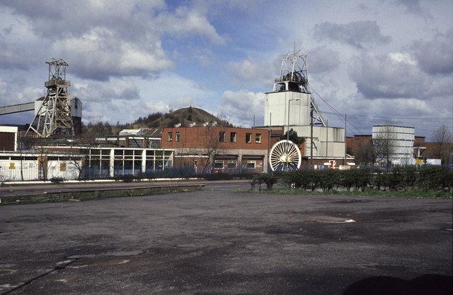
Littleton Colliery was a deep coal mine situated two miles north of Cannock on the A34 in the village of Huntington. The colliery closed on 3 December 1993 and was the last working coal mine on the Cannock Chase Coalfield. History The mine was named after Baron Hatherton Baron Hatherton, of Hatherton in the County of Stafford, is a title in the Peerage of the United Kingdom. It was created in 1835 for the politician Edward Littleton, Chief Secretary for Ireland from 1833 to 1834. Born Edward Walhouse, he assum ... who had assumed the surname Littleton in 1812. First workings at the mine, however, were conducted by the Cannock and Huntingdon Colliery Company in 1877. Upon sinking the first "No. 1" shaft they encountered water at a depth of 438 ft (133 metres) and the shaft became flooded. Lord Hatherton who owned the land on which the colliery was constructed sunk the "No. 2" shaft in 1899 which was completed to a depth of 1,622 ft (494 metres). In the 1960s ... [...More Info...] [...Related Items...] OR: [Wikipedia] [Google] [Baidu] |
Huntington, Staffordshire
Huntington is a civil parish and former mining village in Staffordshire, on the outskirts of Cannock Chase. It lies on the A34 road just north of Cannock and is surrounded by woodland. The village had an estimated population of 3,720 in 2004, increasing to 4,536 at the 2011 Census. The population in Huntington on the 2021 census was 4,715, a 3.94% increase from the decade before. History Early history The name Huntington is possibly Anglo-Saxon in origin, “ton” meaning a hamlet grouped around a hunting lodge in a forest. There is no single source of the settlement's history, but A History of the County of Stafford does provide an important insight into the early period of the village. Although only 4 km from Watling Street, the only Roman evidence found in Huntington was a coin and some pottery found near Cavans Wood in 1950. The Domesday record of 1086 shows the existence of Estendome but this may have been an error by the scribe as in 1198 the name is recorded ... [...More Info...] [...Related Items...] OR: [Wikipedia] [Google] [Baidu] |


