|
Beattock
Beattock is a village in Dumfries and Galloway, Scotland, approximately southwest of Moffat and north of Dumfries. Beattock was historically served by the A74 road and the West Coast Main Line, however the road has since been upgraded to the A74(M) motorway and no longer passes through the village. Beattock railway station was closed in 1972. Beattock Summit is located approximately to the north of the village in the neighbouring administrative area of South Lanarkshire. At it is the highest point on both the M74, and on the West Coast Main Line within Scotland. The poet W. H. Auden's 1936 work Night Mail makes reference to the summit. The Southern Upland Way and the Annandale Way run close to the village. Governance Beattock is in the parliamentary constituency of Dumfriesshire, Clydesdale and Tweeddale, David Mundell is the current Conservative Party member of parliament. Ecclefechan is part of the South Scotland region in the Scottish Parliament, being in the co ... [...More Info...] [...Related Items...] OR: [Wikipedia] [Google] [Baidu] |
Beattock Railway Station
Beattock railway station was a station which served Beattock, in the parish of Kirkpatrick-Juxta in the Scottish county of Dumfries and Galloway. It was served by trains on what is now known as the West Coast Main Line. Following closure in 1972, the nearest station is now at Lockerbie. History Opened by the Caledonian Railway, it became part of the London Midland and Scottish Railway during the Grouping of 1923. It survived the closures in the 1960s, being closed as part of the electrification of the West Coast Main Line, the reason being mentioned by O.S Nock in his book as "the very small amount of traffic currently using it would not warrant the necessary rebuilding and safety improvements to allow electric trains to call."Nock (1974), page 64 Between 1881 and 1964, Beattock was the junction for the branch to Moffat. Just south of Beattock station is the mysterious "Jessie's Tunnel", which intersects the line. There are 3 theories relating to the tunnel and its or ... [...More Info...] [...Related Items...] OR: [Wikipedia] [Google] [Baidu] |
Beattock Summit
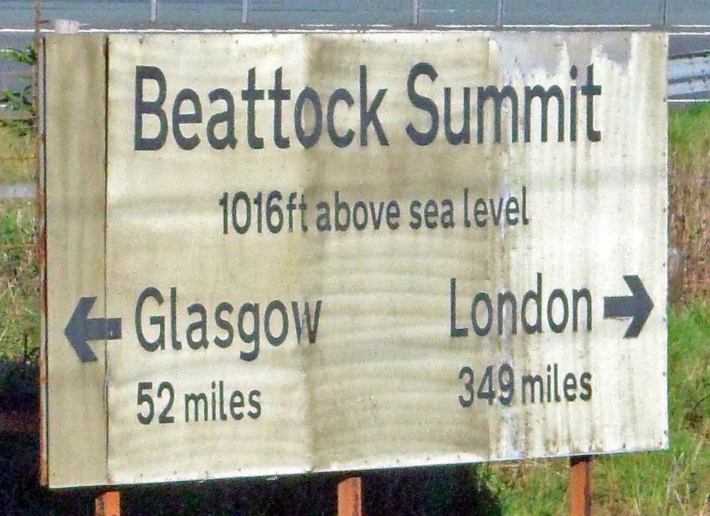
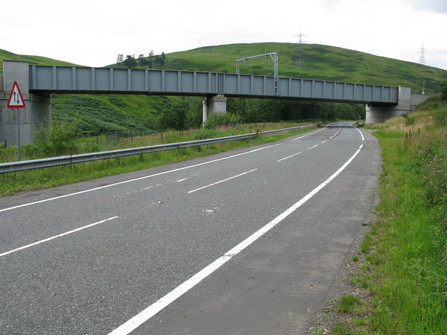
Beattock Summit is the highest point of the West Coast Main Line (WCML) railway and of the A74(M) motorway as they cross between Dumfries and Galloway and South Lanarkshire in south west Scotland. Railway history The highest point on the Caledonian Railway Main Line north of the border (built by the Caledonian Railway and opened on 15 February 1848), it is located 52 miles (83 km) south of Glasgow Central and 349 miles (558 km) north of London Euston stations. The height of the summit is 1,033 feet (315 m) above sea level, which is reached by the adjacent A74(M) motorway. The railway reaches a slightly lower elevation of . The summit is the watershed between the River Clyde to the north and Evan Water, a tributary of the River Annan to the south. The northbound climb has a ascent, with gradients of up to 1 in 69 (1 foot of rising or falling gradient for every 69 feet of distance) which made it a notoriously severe climb in the days of steam ... [...More Info...] [...Related Items...] OR: [Wikipedia] [Google] [Baidu] |
A74 Road
The A74 also known historically as the Glasgow to Carlisle Road, is a formerly major road in the United Kingdom, linking Glasgow in Scotland to Carlisle in the North West of England, passing through Clydesdale, Annandale and the Southern Uplands. A road in this area has existed since Roman Britain, and it was considered one of the most important roads in Scotland, being used as a regular mail service route. The road received a substantial upgrade in the early 19th century under the direction of Thomas Telford, who made significant engineering improvements, including a new route over the Beattock Summit and the Metal Bridge just in England just south of the border. Engineering improvements continued throughout the century and into the 20th, and it became one of the first trunk roads in Britain in 1936. From the 1960s the road started to be replaced by a parallel motorway, largely designated the M74. The last remaining section of all-purpose road on Telford's original align ... [...More Info...] [...Related Items...] OR: [Wikipedia] [Google] [Baidu] |
Night Mail
''Night Mail'' is a 1936 British documentary film directed and produced by Harry Watt and Basil Wright, and produced by the General Post Office (GPO) Film Unit. The 24-minute film documents the nightly postal train operated by the London, Midland and Scottish Railway (LMS) from London to Scotland and the staff who operate it. Narrated by John Grierson and Stuart Legg, the film ends with a "verse commentary" written by W. H. Auden to a score composed by Benjamin Britten. The locomotive featured in the film is LMS Royal Scot Class 6115 ''Scots Guardsman''. ''Night Mail'' premiered on 4 February 1936 at the Cambridge Arts Theatre in Cambridge, England in a launch programme for the venue. Its general release gained critical praise and became a classic of its own kind, much imitated by adverts and modern film shorts. ''Night Mail'' is widely considered a masterpiece of the British Documentary Film Movement. A sequel was released in 1987, entitled ''Night Mail 2''. Synopsis T ... [...More Info...] [...Related Items...] OR: [Wikipedia] [Google] [Baidu] |
Dumfries And Galloway
Dumfries and Galloway ( sco, Dumfries an Gallowa; gd, Dùn Phrìs is Gall-Ghaidhealaibh) is one of 32 unitary council areas of Scotland and is located in the western Southern Uplands. It covers the historic counties of Dumfriesshire, Kirkcudbrightshire, and Wigtownshire, the latter two of which are collectively known as Galloway. The administrative centre and largest settlement is the town of Dumfries. The second largest town is Stranraer, on the North Channel coast, some to the west of Dumfries. Following the 1975 reorganisation of local government in Scotland, the three counties were joined to form a single region of Dumfries and Galloway, with four districts within it. The districts were abolished in 1996, since when Dumfries and Galloway has been a unitary local authority. For lieutenancy purposes, the area is divided into three lieutenancy areas called Dumfries, Wigtown and the Stewartry of Kirkcudbright, broadly corresponding to the three historic counties. ... [...More Info...] [...Related Items...] OR: [Wikipedia] [Google] [Baidu] |
West Coast Main Line
The West Coast Main Line (WCML) is one of the most important railway corridors in the United Kingdom, connecting the major cities of London and Glasgow with branches to Birmingham, Liverpool, Manchester and Edinburgh. It is one of the busiest mixed-traffic railway routes in Europe, carrying a mixture of intercity rail, regional rail, commuter rail and rail freight traffic. The core route of the WCML runs from London to Glasgow for and was opened from 1837 to 1869. With additional lines deviating to Northampton, Birmingham, Manchester, Liverpool and Edinburgh, this totals a route mileage of . The Glasgow–Edinburgh via Carstairs line connects the WCML to Edinburgh, however the main London–Edinburgh route is the East Coast Main Line. Several sections of the WCML form part of the suburban railway systems in London, Coventry, Birmingham, Liverpool, Manchester and Glasgow, with many more smaller commuter stations, as well as providing links to more rural towns. It is one of ... [...More Info...] [...Related Items...] OR: [Wikipedia] [Google] [Baidu] |
Southern Upland Way
The Southern Upland Way is a coast-to-coast long-distance footpath in southern Scotland. The route links Portpatrick in the west and Cockburnspath in the east via the hills of the Southern Uplands. The Way is designated as one of Scotland's Great Trails by NatureScot and is the longest of the 29 Great Trails. The Southern Upland Way meets with seven of the other Great Trails: the Annandale Way, the Berwickshire Coastal Path, the Borders Abbeys Way, the Cross Borders Drove Road, the Mull of Galloway Trail, the Romans and Reivers Route and St Cuthbert's Way. The path is maintained by the local authorities of the two main council areas through which it passes: Dumfries and Galloway Council and Scottish Borders Council; a short section in the Lowther Hills lies in South Lanarkshire.Ordnance Survey ''Landranger'' 1:50000 map. Sheet 78 (Nithsdale & Annandale). It is primarily intended for walkers, but many parts are suitable for mountain bikers; some sections are also su ... [...More Info...] [...Related Items...] OR: [Wikipedia] [Google] [Baidu] |
Moffat
Moffat ( gd, Mofad) is a burgh and parish in Dumfriesshire, now part of the Dumfries and Galloway local authority area in Scotland. It lies on the River Annan, with a population of around 2,500. It was a centre of the wool trade and a spa town. Moffat is around to the southeast of Glasgow, southwest of Edinburgh, northeast of Dumfries and northwest of Carlisle. The Moffat House Hotel, located at the northern end of the High Street, was designed by John Adam. The nearby Star Hotel, a mere 20 ft (6 m) wide, was listed in the Guinness Book of Records as the narrowest hotel in the world. Moffat won the Britain in Bloom contest in 1996. Moffat is home to Moffat toffee. The town is held to be the ancestral seat of Clan Moffat. The Devil's Beef Tub near Moffat was used by the members of Clan Moffat and later the members of Clan Johnstone to hoard cattle stolen in predatory raids. Early tourism as a spa town From 1633 Moffat began to grow from a small villag ... [...More Info...] [...Related Items...] OR: [Wikipedia] [Google] [Baidu] |
M74 Motorway
The A74(M) and M74 form a major motorway in Scotland, connecting it to England. The routes connect the M8 motorway in central Glasgow to the Scottish-English border at Gretna. In conjunction with their southward continuation, the M6 motorway, they form one of the three major cross-border routes between Scotland and England. They are part of the unsigned international E-road network E05. Although the entire route is colloquially referred to as the M74, for more than half its length, south of Abington, the road is officially the A74(M); see '' naming confusion'' below. Route From its junction with the M8 just south of the Kingston Bridge, the newest section passes through the Glasgow districts of Govanhill, Polmadie, Oatlands and parts of the nearby towns of Rutherglen and Cambuslang, on an elevated embankment, with junctions at Kingston, Polmadie Road, Eastfield and Tollcross before connecting to the much older section of the M74. It then runs in a roughly south-easte ... [...More Info...] [...Related Items...] OR: [Wikipedia] [Google] [Baidu] |
Dumfries
Dumfries ( ; sco, Dumfries; from gd, Dùn Phris ) is a market town and former royal burgh within the Dumfries and Galloway council area of Scotland. It is located near the mouth of the River Nith into the Solway Firth about by road from the Anglo-Scottish border and just away from Cumbria by air. Dumfries is the county town of the historic county of Dumfriesshire. Before becoming King of Scots, Robert the Bruce killed his rival the Red Comyn at Greyfriars Kirk in the town on 10 February 1306. The Young Pretender had his headquarters here during a 3-day sojourn in Dumfries towards the end of 1745. During the Second World War, the bulk of the Norwegian Army during their years in exile in Britain consisted of a brigade in Dumfries. Dumfries is nicknamed ''Queen of the South''. This is also the name of the town's professional football club. People from Dumfries are known colloquially in Scots language as ''Doonhamers''. Toponymy There are a number of theories ... [...More Info...] [...Related Items...] OR: [Wikipedia] [Google] [Baidu] |
Annandale Way
The Annandale Way is a hiking trail in Scotland, which is officially designated by NatureScot as one of Scotland's Great Trails. It follows the valley of the River Annan from its source in the Moffat Hills to the sea in the Solway Firth south of the town of Annan. The route, which was established on 12 September 2009, has been designed to be traversable in four to five days as a continuous walk but it also offers several day-walks. Overnight stops can be arranged in small market towns and villages along the route such as Moffat, Johnstonebridge, Lochmaben, Lockerbie, or Annan. The route has been developed by Sulwath Connections and local communities, with the support of local estates and farmers, to help promote Annandale as a new area for walking. Its trailheads are near the Devil's Beef Tub in the Moffat Hills and on the Solway Firth just south of Annan, in Newbie. Route description Way (right edge of the picture) with the Solway Firth and Criffel beyond; which ... [...More Info...] [...Related Items...] OR: [Wikipedia] [Google] [Baidu] |
A74(M) And M74 Motorways
The A74(M) and M74 form a major motorway in Scotland, connecting it to England. The routes connect the M8 motorway in central Glasgow to the Scottish-English border at Gretna. In conjunction with their southward continuation, the M6 motorway, they form one of the three major cross-border routes between Scotland and England. They are part of the unsigned international E-road network E05. Although the entire route is colloquially referred to as the M74, for more than half its length, south of Abington, the road is officially the A74(M); see '' naming confusion'' below. Route From its junction with the M8 just south of the Kingston Bridge, the newest section passes through the Glasgow districts of Govanhill, Polmadie, Oatlands and parts of the nearby towns of Rutherglen and Cambuslang, on an elevated embankment, with junctions at Kingston, Polmadie Road, Eastfield and Tollcross before connecting to the much older section of the M74. It then runs in a roughly sou ... [...More Info...] [...Related Items...] OR: [Wikipedia] [Google] [Baidu] |


