|
Bucegi
The Bucegi Mountains (Romanian: ''Munții Bucegi'' ) are located in central Romania, south of the city of Brașov. They are part of the Southern Carpathians group of the Carpathian Mountains. At , '' Omu'' is its highest point. To the east, the Bucegi Mountains have a very steep slope towards the popular tourist destinations in the Prahova Valley, such as Bușteni and Sinaia. At a higher elevation is the Bucegi Plateau, where wind and rain have turned the rocks into spectacular figures such as the Sphinx and ''Babele''. The Bucegi is believed to be the Dacian holy mountain ''Kogainon'', on which the God Zalmoxis resided in a cave. Name The exact origin of the name "Bucegi" is disputed by philologists. "Buceag" or "bugeac" seems to be the source of the name, a word designating in the language of mountain people both the moss in the forest and the wilderness or the junipers. An archaic version of the name "Bucegi" is "Buceci", name still used today by elders in the mountains, ... [...More Info...] [...Related Items...] OR: [Wikipedia] [Google] [Baidu] |
Southern Carpathians
The Southern Carpathians (also known as the Transylvanian Alps; ro, Carpații Meridionali ; hu, Déli-Kárpátok) are a group of mountain ranges located in southern Romania. They cover the part of the Carpathian Mountains located between the Prahova River in the east and the Timiș and Cerna Rivers in the west. To the south they are bounded by the Balkan mountain range in eastern Serbia. Heights The Southern Carpathians are the second highest group of mountains in the Carpathian Mountain range (after Tatra), reaching heights of over 2,500 meters. Although considerably smaller than the Alps, they are classified as having an alpine landscape. Their high mountain character, combined with great accessibility, makes them popular with tourists and scientists. The highest peaks are: * Moldoveanu Peak, 2,544 metres – Făgăraș Mountains * Negoiu, 2,535 metres – Făgăraș Mountains * Parângu Mare, 2,519 metres – Parâng Mountains * Omu Peak 2,514 metres – Bucegi Mounta ... [...More Info...] [...Related Items...] OR: [Wikipedia] [Google] [Baidu] |
Sphinx (Romania)
The Sphinx ( ro, Sfinxul) is a natural rock formation in the Bucegi Natural Park which is in the Bucegi Mountains of Romania. It is located at an altitude of within the Babele complex of rock formations. The first photo of the ''Great Bucegi Sphinx'' was probably taken in about the year 1900. This photograph was taken from a front position, not from a lateral one, as it usually appears in modern pictures. It only acquired its nickname, referring to the Great Sphinx of Giza, in the year 1936. The image of the sphinx appears when the rock, having an 8 m height and a 12 m width, is observed from a certain angle. The megalith has its clearest outline on 21 November, at the time the sun goes down. In Romanian film The Sphinx features in the 1967 film '' The Dacians'', in which it is a place of sacrifice to the god Zalmoxis. It also plays a significant role in the 1980 film ''Burebista'', in which it is equated with the eponymous ancient Dacian king and the eternity of Romanian iden ... [...More Info...] [...Related Items...] OR: [Wikipedia] [Google] [Baidu] |
Sinaia
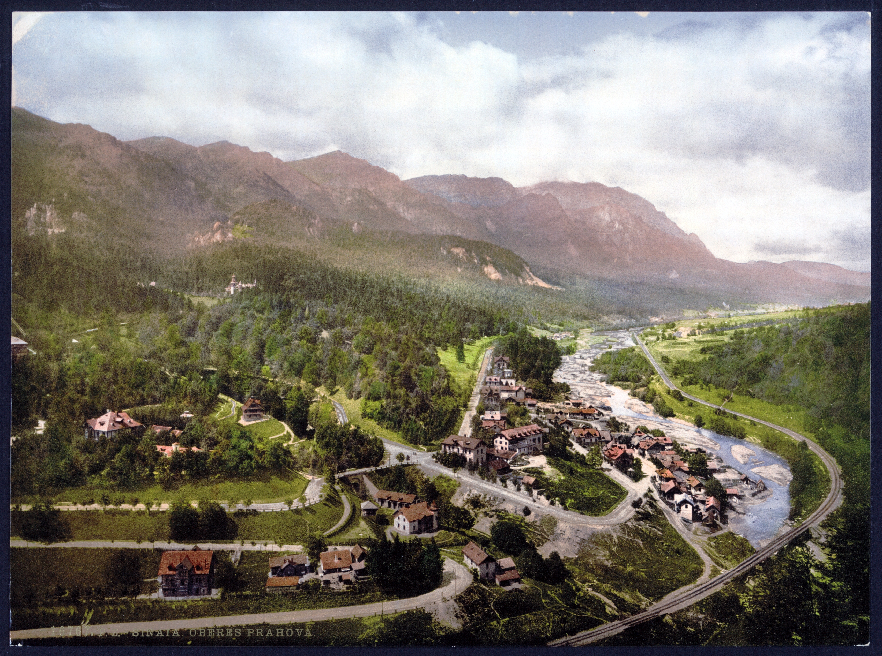
Sinaia () is a town and a mountain resort in Prahova County, Romania. It is situated in the historical region of Muntenia. The town was named after the Sinaia Monastery of 1695, around which it was built. The monastery, in turn, is named after the Biblical Mount Sinai. King Carol I of Romania also built his summer residence, Peleș Castle, in Sinaia in the late nineteenth century. Sinaia is about northwest of Ploiești and south of Brașov, in a mountainous area on the Prahova River valley, just east of the Bucegi Mountains. The town's altitude varies between above mean sea level, above sea level. The city is a popular destination for hiking and winter sports, especially downhill skiing. Among the tourist landmarks, the most important are Peleș Castle, Pelișor Castle, Sinaia Monastery, Sinaia Casino, Sinaia train station, and the Franz Joseph and Saint Anne Cliffs. Sinaia was also the summer residence of the Romanian composer George Enescu, who stayed at the Luminiș villa. ... [...More Info...] [...Related Items...] OR: [Wikipedia] [Google] [Baidu] |
Babele
Babele (meaning ''The old women'') is a name for an area on the Bucegi Mountains plateau in Romania, within the Southern Carpathians. Babele is one of the most popular tourist destinations in the country. The name comes from some mushroom shaped rock formations, the result of erosion and varying hardness of the rock layers. The Bucegi Sphinx (Romania), Sphinx is another rock formation in the same area, named for its sphinx-like appearance. The ''Babele chalet'' is accessible either by cable car from Bușteni or by road. It can also be reached by foot, coming from Bușteni through ''Valea Jepilor'' (Juniper Valley), or from the crest of the Bucegi Mountains, coming from the Piatra Arsă (The Burned Rock) chalet. See also * Seven Natural Wonders of Romania Mountains of Romania Southern Carpathians Tourist attractions in Prahova County Geography of Prahova County {{Romania-geo-stub ... [...More Info...] [...Related Items...] OR: [Wikipedia] [Google] [Baidu] |
Omu Peak
Omu Peak ( ro, Vârful Omu) is a mountain peak of the Bucegi Mountains in Romania. It is located in Brașov, Dâmbovița and Prahova counties A county is a geographic region of a country used for administrative or other purposesChambers Dictionary, L. Brookes (ed.), 2005, Chambers Harrap Publishers Ltd, Edinburgh in certain modern nations. The term is derived from the Old French .... The top of Omu Peak is flat and sprawling; there is a weather station and a tourist shelter (Romanian cabana) Omu (2505 m above sea level), which is the highest mountain shelter in the entire Carpathians. The first wooden shelter was built in 1888 on the initiative of the Transylvanian Carpathian Society. Rebuilt many times, it is now as a stone and wooden building, it offers 30 beds and a buffet. The hostel does not have electricity and running water. It is open from March to November. The top of the mountain is a rock, several meters, which is probably why different sources indicate dif ... [...More Info...] [...Related Items...] OR: [Wikipedia] [Google] [Baidu] |
Bușteni
Bușteni () is a small mountain town in the north of Prahova County, Muntenia, Romania. It is located in the Prahova Valley, at the bottom of the Bucegi Mountains, that have a maximum altitude of . Its name literally means tree-logs in Romanian. One village, Poiana Țapului, is administratively part of the town, formerly a separate commune prior to 1950. According to the 2011 census, it has 8,894 inhabitants. Bușteni's average altitude is . It is one of the most popular mountain resorts in Romania, with year-round tourism opportunities, including skiing and mountain climbing. The town and the surrounding mountains were the site of military confrontations in 1916, during World War I (''see Romania during World War I''). A large commemorative monument (about high), Heroes' Cross (''Crucea Eroilor'') lies atop nearby Caraiman Peak, at nearly . The monument is lighted at night and is visible from virtually everywhere in Bușteni. The main local industries are wood industry and ... [...More Info...] [...Related Items...] OR: [Wikipedia] [Google] [Baidu] |
Carpathian Mountains
The Carpathian Mountains or Carpathians () are a range of mountains forming an arc across Central Europe. Roughly long, it is the third-longest European mountain range after the Urals at and the Scandinavian Mountains at . The range stretches from the far eastern Czech Republic (3%) and Austria (1%) in the northwest through Slovakia (21%), Poland (10%), Ukraine (10%), Romania (50%) to Serbia (5%) in the south. "The Carpathians" European Travel Commission, in The Official Travel Portal of Europe, Retrieved 15 November 2016 The Carpathian ... [...More Info...] [...Related Items...] OR: [Wikipedia] [Google] [Baidu] |
Piatra Craiului Mountains
The Piatra Craiului Mountains (german: Königstein, hu, Királykő-hegység) are a mountain range in the Southern Carpathians in Romania. Its name is translated as ''Kings' Rock'' or ''The Rock of the Prince''. The mountain range is located in Brașov and Argeș counties; it is included in the Piatra Craiului National Park, which covers an area of . The Piatra Craiului mountains form a narrow and saw-like ridge, which is about long. The highest elevation in the massif is the "Vârful La Om" at . The ridge is regarded as one of the most beautiful sites in the Carpathians. The two-day north–south ridge trail is both challenging and rewarding. Starting at either Plaiul Foii in the north-west or Curmătura in the north-east, walkers climb up to the ridge before following a somewhat precarious path along the narrow spine. The descent at the southern end leads into a karst landscape of deep gorges and pitted slopes where water penetrating the rock has carved a series of caves ... [...More Info...] [...Related Items...] OR: [Wikipedia] [Google] [Baidu] |
Rucăr-Bran Pass
The Rucăr-Bran Pass, also called in English the Bran Pass (german: Törzburger Pass, hu, Törcsvári-szoros), is a mountain pass in Romania, linking the counties of Brașov and Argeș. It has some of the most spectacular natural views in Romania, looking over the Bucegi Mountains of the Southern Carpathians. The Pass starts in the commune of Rucăr, Argeș County, and runs for about in a northeasterly direction. The communes of Fundata (including Șirnea village) and Moieciu, both in Brașov County, lie within the Pass, which ends in Bran. National road DN73 runs through the Pass, connecting the city of Pitești, southwest of Rucăr, to the city of Brașov, northeast of Bran. History In 1382, Bran Castle was built by the Transylvanian Saxons of Brașov to defend the Pass from the Ottomans. In the year 1413, a customs post in the Pass was licensed by the ruler of Wallachia. This charged a duty on all goods brought through the Pass. Southwards the usual trade route ran ... [...More Info...] [...Related Items...] OR: [Wikipedia] [Google] [Baidu] |
Prahova County
Prahova County () is a county ( județ) of Romania, in the historical region Muntenia, with the capital city at Ploiești. Demographics In 2011, it had a population of 762,886 and the population density was 161/km². It is Romania's third most populated county (after the Municipality of Bucharest and Iași County), having a population density double that of the country's mean. * Romanians - 97.74% * Romas and others - 2.26% The county received an inflow of population who have moved here due to the industrial development. Geography This county has a total area of 4,716 km². The relief is split in approximately equal parts between the mountains, the hills and the plain. In the North side there are mountains from the southern end of the Eastern Carpathians - the Curvature Carpathians group; and the Bucegi Mountains the Eastern end of the Southern Carpathians group. The two groups are separated by the Prahova River Valley. The south side of the county is a plain, o ... [...More Info...] [...Related Items...] OR: [Wikipedia] [Google] [Baidu] |
Leaota Mountains
The Leaota Mountains are located in central Romania, north of the city Târgovişte. They are part of the Southern Carpathians group of the Carpathian Mountains, and have as neighbours the Bucegi Mountains to the east and Piatra Craiului The Piatra Craiului Mountains (german: Königstein, hu, Királykő-hegység) are a mountain range in the Southern Carpathians in Romania. Its name is translated as ''Kings' Rock'' or ''The Rock of the Prince''. The mountain range is located ... to the west. The 2,133 meters high pyramidal Leaota peak raises in a superb land of dense fir forests, wild animals, few wanderer shepherds, and almost no tourists. Leaota tourist shelter (Romanian cabana) The shelter was built in the 1940s at an altitude of 1.330 meters above sea level. It is currently abandoned, being used sporadically by passing tourists. In 1962 the chalet had running water, electricity generator, permanent buffet and ski slopes arranged nearby. Until 2004, the chalet of the ... [...More Info...] [...Related Items...] OR: [Wikipedia] [Google] [Baidu] |
Prahova Valley
Prahova Valley (Romanian: ''Valea Prahovei'') is the valley where the Prahova river makes its way between the Bucegi and the Baiu Mountains, in the Carpathian Mountains, Romania. It is a tourist region, situated about north of the capital city of Bucharest. World War I During World War I, the area was the site of heavy fighting between Austro-Hungarian and German forces on one side and Romanian forces on the other. The strategic objective of the Central Powers was to reach Bucharest via the shortest route, but they were prevented from doing so by determined Romanian resistance. Geography Geographically, the Prahova river separates the Eastern Carpathians chain from the Southern Carpathians. Historically, the corridor was the most important passageway between the principalities of Wallachia and Transylvania. The DN1 road links Bucharest with the city of Brașov; the planned A3 freeway is currently being built along the Prahova Valley. After failing to take part in the ho ... [...More Info...] [...Related Items...] OR: [Wikipedia] [Google] [Baidu] |


