|
British Imperial Lifeline
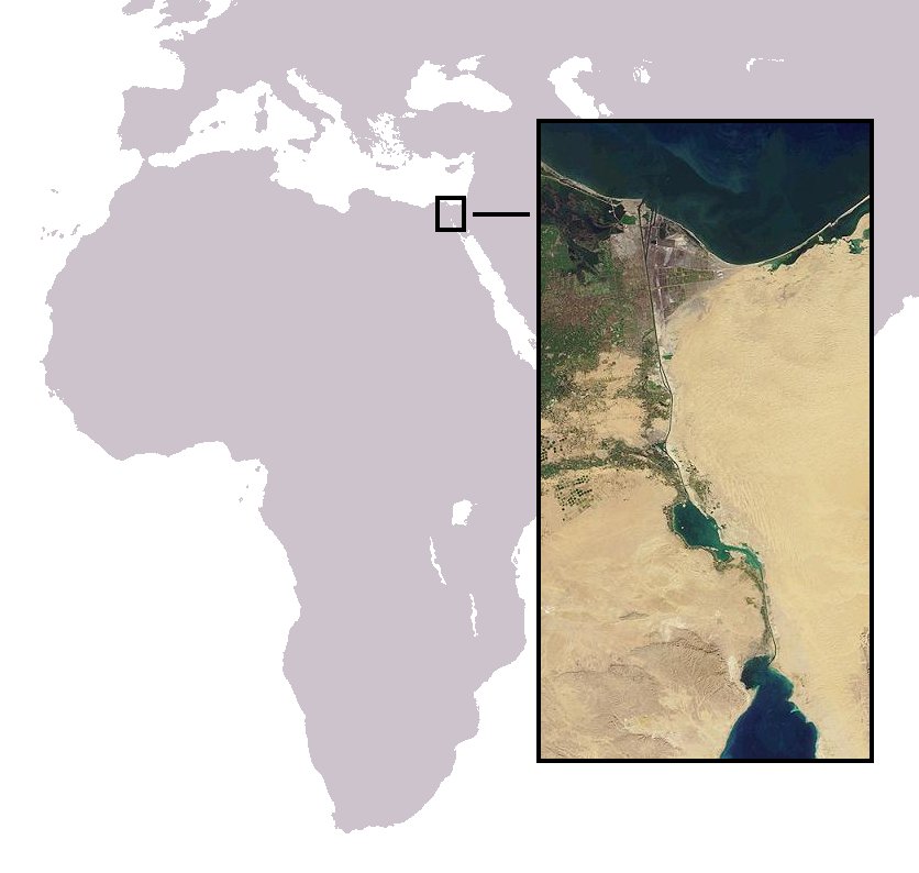
An All-Red Route was, originally, a steamship route used by Royal Mail Ships during the heyday of the British Empire. The name derives from the common practice of colouring the territory of the British Empire red or pink on political maps. It denoted a long-distance route where all the ports of call were in British territories or colonies, emphasising not only the usefulness of the route as a means of connecting the British metropole with the worldwide empire but also the strategic security of being able to connect (and travel between) possessions on the other side of the globe without having to rely on making stops in, or passing through, the territory of another nation. Initially the term was used to apply only to steamship routes (as these were the only practical way of carrying communications between Great Britain and the rest of the Empire), particularly to India via the Suez Canal—a route sometimes referred to as the British Imperial Lifeline. Rail transport was used acros ... [...More Info...] [...Related Items...] OR: [Wikipedia] [Google] [Baidu] |
Steamship
A steamship, often referred to as a steamer, is a type of steam-powered vessel, typically ocean-faring and seaworthy, that is propelled by one or more steam engines that typically move (turn) propellers or paddlewheels. The first steamships came into practical usage during the early 1800s; however, there were exceptions that came before. Steamships usually use the prefix designations of "PS" for ''paddle steamer'' or "SS" for ''screw steamer'' (using a propeller or screw). As paddle steamers became less common, "SS" is assumed by many to stand for "steamship". Ships powered by internal combustion engines use a prefix such as "MV" for ''motor vessel'', so it is not correct to use "SS" for most modern vessels. As steamships were less dependent on wind patterns, new trade routes opened up. The steamship has been described as a "major driver of the first wave of trade globalization (1870–1913)" and contributor to "an increase in international trade that was unprecedented in hu ... [...More Info...] [...Related Items...] OR: [Wikipedia] [Google] [Baidu] |
Suez Crisis
The Suez Crisis, or the Second Arab–Israeli war, also called the Tripartite Aggression ( ar, العدوان الثلاثي, Al-ʿUdwān aṯ-Ṯulāṯiyy) in the Arab world and the Sinai War in Israel,Also known as the Suez War or 1956 War; other names include the ''Sinai war'', ''Suez–Sinai war'', ''1956 Arab–Israeli war'', the Second Arab–Israeli war, ''Suez Campaign'', ''Sinai Campaign'', ''Kadesh Operation'' and ''Operation Musketeer'' was an invasion of Egypt in late 1956 by Israel, followed by the United Kingdom and France. The aims were to regain control of the Suez Canal for the Western powers and to remove Egyptian president Gamal Abdel Nasser, who had just swiftly nationalised the foreign-owned Suez Canal Company, which administered the canal. Israel's primary objective was to re-open the blocked Straits of Tiran. After the fighting had started, political pressure from the United States, the Soviet Union and the United Nations led to a withdrawal by the ... [...More Info...] [...Related Items...] OR: [Wikipedia] [Google] [Baidu] |
Burma
Myanmar, ; UK pronunciations: US pronunciations incl. . Note: Wikipedia's IPA conventions require indicating /r/ even in British English although only some British English speakers pronounce r at the end of syllables. As John Wells explains, the English spellings of both Myanmar and Burma assume a non-rhotic variety of English, in which the letter r before a consonant or finally serves merely to indicate a long vowel: �mjænmɑː, ˈbɜːmə So the pronunciation of the last syllable of Myanmar as ɑːror of Burma as ɜːrməby some speakers in the UK and most speakers in North America is in fact a spelling pronunciation based on a misunderstanding of non-rhotic spelling conventions. The final ''r'' in ''Myanmar'' was not intended for pronunciation and is there to ensure that the final a is pronounced with the broad ''ah'' () in "father". If the Burmese name my, မြန်မာ, label=none were spelled "Myanma" in English, this would be pronounced at the end by all ... [...More Info...] [...Related Items...] OR: [Wikipedia] [Google] [Baidu] |
Sri Lanka
Sri Lanka (, ; si, ශ්රී ලංකා, Śrī Laṅkā, translit-std=ISO (); ta, இலங்கை, Ilaṅkai, translit-std=ISO ()), formerly known as Ceylon and officially the Democratic Socialist Republic of Sri Lanka, is an island country in South Asia. It lies in the Indian Ocean, southwest of the Bay of Bengal, and southeast of the Arabian Sea; it is separated from the Indian subcontinent by the Gulf of Mannar and the Palk Strait. Sri Lanka shares a maritime border with India and Maldives. Sri Jayawardenepura Kotte is its legislative capital, and Colombo is its largest city and financial centre. Sri Lanka has a population of around 22 million (2020) and is a multinational state, home to diverse cultures, languages, and ethnicities. The Sinhalese are the majority of the nation's population. The Tamils, who are a large minority group, have also played an influential role in the island's history. Other long established groups include the Moors, the Burghers ... [...More Info...] [...Related Items...] OR: [Wikipedia] [Google] [Baidu] |
Persian Gulf
The Persian Gulf ( fa, خلیج فارس, translit=xalij-e fârs, lit=Gulf of Persis, Fars, ), sometimes called the ( ar, اَلْخَلِيْجُ ٱلْعَرَبِيُّ, Al-Khalīj al-ˁArabī), is a Mediterranean sea (oceanography), mediterranean sea in Western Asia. The body of water is an extension of the Indian Ocean located between Iran and the Arabian Peninsula.United Nations Group of Experts on Geographical NameWorking Paper No. 61, 23rd Session, Vienna, 28 March – 4 April 2006. accessed October 9, 2010 It is connected to the Gulf of Oman in the east by the Strait of Hormuz. The Shatt al-Arab river delta forms the northwest shoreline. The Persian Gulf has many fishing grounds, extensive reefs (mostly rocky, but also Coral reef, coral), and abundant pearl oysters, however its ecology has been damaged by industrialization and oil spills. The Persian Gulf is in the Persian Gulf Basin, which is of Cenozoic origin and related to the subduction of the Arabian Plate u ... [...More Info...] [...Related Items...] OR: [Wikipedia] [Google] [Baidu] |
Muscat, Oman
Muscat ( ar, مَسْقَط, ) is the Capital (political), capital and most populated city in Oman. It is the seat of the Muscat (governorate), Governorate of Muscat. According to the National Centre for Statistics and Information (NCSI), the total population of Muscat Governorate was 1.4 million as of September 2018. The metropolitan area spans approximately and includes six Provinces of Oman, provinces called . Known since the early 1st century Anno Domini, AD as an important trading port between the Western world, west and the Eastern world, east, Muscat was ruled by various indigenous tribes as well as foreign powers such as the Sassanid Empire, Persians, the Portuguese Empire and the Ottoman Empire at various points in its history. A regional military power in the 18th century, Muscat's influence extended as far as East Africa and Zanzibar. As an important port-town in the Gulf of Oman, Muscat attracted foreign tradesmen and settlers such as the Persians, Baloch people, Bal ... [...More Info...] [...Related Items...] OR: [Wikipedia] [Google] [Baidu] |
Aden
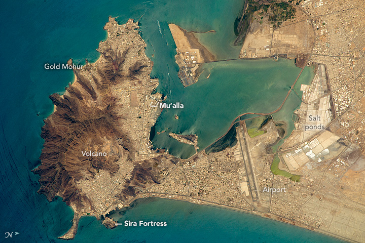
Aden ( ar, عدن ' Yemeni: ) is a city, and since 2015, the temporary capital of Yemen, near the eastern approach to the Red Sea (the Gulf of Aden), some east of the strait Bab-el-Mandeb. Its population is approximately 800,000 people. Aden's natural harbour lies in the crater of a dormant volcano, which now forms a peninsula joined to the mainland by a low isthmus. This harbour, Front Bay, was first used by the ancient Kingdom of Awsan between the 7th to 5th centuries BC. The modern harbour is on the other side of the peninsula. Aden gets its name from the Gulf of Aden. Aden consists of a number of distinct sub-centres: Crater, the original port city; Ma'alla, the modern port; Tawahi, known as "Steamer Point" in the colonial period; and the resorts of Gold Mohur. Khormaksar, on the isthmus that connects Aden proper with the mainland, includes the city's diplomatic missions, the main offices of Aden University, and Aden International Airport (the former British Roy ... [...More Info...] [...Related Items...] OR: [Wikipedia] [Google] [Baidu] |
Port Said
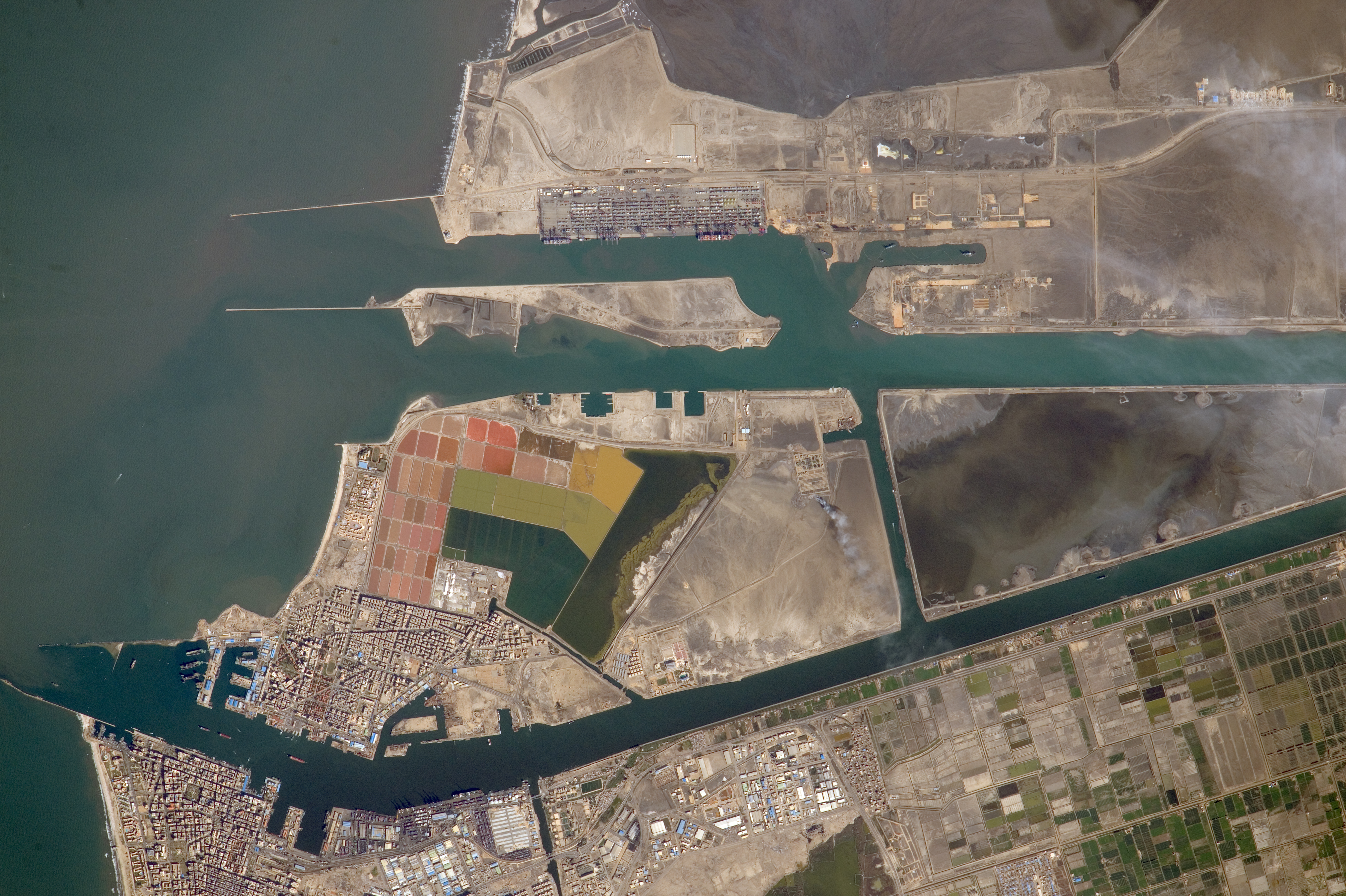
Port Said ( ar, بورسعيد, Būrsaʿīd, ; grc, Πηλούσιον, Pēlousion) is a city that lies in northeast Egypt extending about along the coast of the Mediterranean Sea, north of the Suez Canal. With an approximate population of 603,787 (2010), it is the List of cities and towns in Egypt, fifth-largest city in Egypt. The city was established in 1859 during the building of the Suez Canal. There are numerous old houses with grand balconies on all floors, giving the city a distinctive look. Port Said's twin city is Port Fuad, which lies on the eastern bank of the Suez Canal. The two cities coexist, to the extent that there is hardly any town centre in Port Fuad. The cities are connected by free Ferry, ferries running all through the day, and together they form a metropolitan area with over a million residents that extends both on the African and the Asian sides of the Suez Canal. The only other metropolitan area in the world that also spans two continents is Istanbul. ... [...More Info...] [...Related Items...] OR: [Wikipedia] [Google] [Baidu] |
Alexandria
Alexandria ( or ; ar, ٱلْإِسْكَنْدَرِيَّةُ ; grc-gre, Αλεξάνδρεια, Alexándria) is the second largest city in Egypt, and the largest city on the Mediterranean coast. Founded in by Alexander the Great, Alexandria grew rapidly and became a major centre of Hellenic civilisation, eventually replacing Memphis, in present-day Greater Cairo, as Egypt's capital. During the Hellenistic period, it was home to the Lighthouse of Alexandria, which ranked among the Seven Wonders of the Ancient World, as well as the storied Library of Alexandria. Today, the library is reincarnated in the disc-shaped, ultramodern Bibliotheca Alexandrina. Its 15th-century seafront Qaitbay Citadel is now a museum. Called the "Bride of the Mediterranean" by locals, Alexandria is a popular tourist destination and an important industrial centre due to its natural gas and oil pipelines from Suez. The city extends about along the northern coast of Egypt, and is the largest city on t ... [...More Info...] [...Related Items...] OR: [Wikipedia] [Google] [Baidu] |
Malta
Malta ( , , ), officially the Republic of Malta ( mt, Repubblika ta' Malta ), is an island country in the Mediterranean Sea. It consists of an archipelago, between Italy and Libya, and is often considered a part of Southern Europe. It lies south of Sicily (Italy), east of Tunisia, and north of Libya. The official languages are Maltese and English, and 66% of the current Maltese population is at least conversational in the Italian language. Malta has been inhabited since approximately 5900 BC. Its location in the centre of the Mediterranean has historically given it great strategic importance as a naval base, with a succession of powers having contested and ruled the islands, including the Phoenicians and Carthaginians, Romans, Greeks, Arabs, Normans, Aragonese, Knights of St. John, French, and British, amongst others. With a population of about 516,000 over an area of , Malta is the world's tenth-smallest country in area and fourth most densely populated sovereign cou ... [...More Info...] [...Related Items...] OR: [Wikipedia] [Google] [Baidu] |
Gibraltar
) , anthem = " God Save the King" , song = " Gibraltar Anthem" , image_map = Gibraltar location in Europe.svg , map_alt = Location of Gibraltar in Europe , map_caption = United Kingdom shown in pale green , mapsize = , image_map2 = Gibraltar map-en-edit2.svg , map_alt2 = Map of Gibraltar , map_caption2 = Map of Gibraltar , mapsize2 = , subdivision_type = Sovereign state , subdivision_name = , established_title = British capture , established_date = 4 August 1704 , established_title2 = , established_date2 = 11 April 1713 , established_title3 = National Day , established_date3 = 10 September 1967 , established_title4 = Accession to EEC , established_date4 = 1 January 1973 , established_title5 = Withdrawal from the EU , established_date5 = 31 January 2020 , official_languages = English , languages_type = Spoken languages , languages = , capital = Westside, Gibraltar (de facto) , coordinates = , largest_settlement_type = largest district , l ... [...More Info...] [...Related Items...] OR: [Wikipedia] [Google] [Baidu] |
Southern Britain
England and Wales () is one of the three legal jurisdictions of the United Kingdom. It covers the constituent countries England and Wales and was formed by the Laws in Wales Acts 1535 and 1542. The substantive law of the jurisdiction is English law. The devolved Senedd (Welsh Parliament; cy, Senedd Cymru) – previously named the National Assembly of Wales – was created in 1999 by the Parliament of the United Kingdom under the Government of Wales Act 1998 and provides a degree of self-government in Wales. The powers of the Parliament were expanded by the Government of Wales Act 2006, which allows it to pass its own laws, and the Act also formally separated the Welsh Government from the Senedd. There is no equivalent body for England, which is directly governed by the parliament and government of the United Kingdom. History of jurisdiction During the Roman occupation of Britain, the area of present-day England and Wales was administered as a single unit, except for the ... [...More Info...] [...Related Items...] OR: [Wikipedia] [Google] [Baidu] |


