|
Bolshekolpanskoe Rural Settlement
Bolshekolpanskoe Rural Settlement is a rural settlement in Gatchina Municipal District of the Leningrad Oblast (Leningrad Province) in northern Russia. The Bolshekolpanskoe Rural Settlement contains 16 villages.), the others are villages (russian: деревня); both terms translate to "village", the traditional difference being that selos have a church. The village of Great Kolpany, with a population over 4,000 (2012) would usually be called a "town" in most of the English-speaking world, but Russian does not distinguish between cities and towns (both are called "gorod" (russian: город)) and criteria for town/city status is higher (12,000 inhabitants, usually)., group=note The administrative center is the village of Bolshiye Kolpany (Great Kolpany). Geography The Bolshekolpanskoe Rural Settlement is near the center of the Gatchina District, bordered on the north by the Pudostskim Rural Settlement, on the north-east by the Novyi Svet Rural Settlement and the City of Gatchina ... [...More Info...] [...Related Items...] OR: [Wikipedia] [Google] [Baidu] |
Rural Settlement (Russia)
A rural settlement is a self-governing political division in Russia. A rural settlement is composed of one or more contiguous rural communities: towns, villages, hamlets, farmsteads, exurbs, resorts, villas, stanitsas (Cossack settlements), kishlaks (settlements of Turkic peoples), auls (Caucasian fortified villages), or any other type. Political authority in rural settlements is exercised by the inhabitants, either directly or through elected (or otherwise constituted) bodies. A rural settlement is a constituent part of a municipal district, a political entity created as part of municipal reforms in 2004. Prior to 2004, the district (raion), inherited from the Soviet Union, had been the primary division next lowest below oblast (province). (A municipal district may, in addition to or instead of rural settlements, include urban settlements, which are composed of various urban communitiess.) The term "rural settlement" is also used in its generic sense to denote any rural inhabited ... [...More Info...] [...Related Items...] OR: [Wikipedia] [Google] [Baidu] |
Gatchina
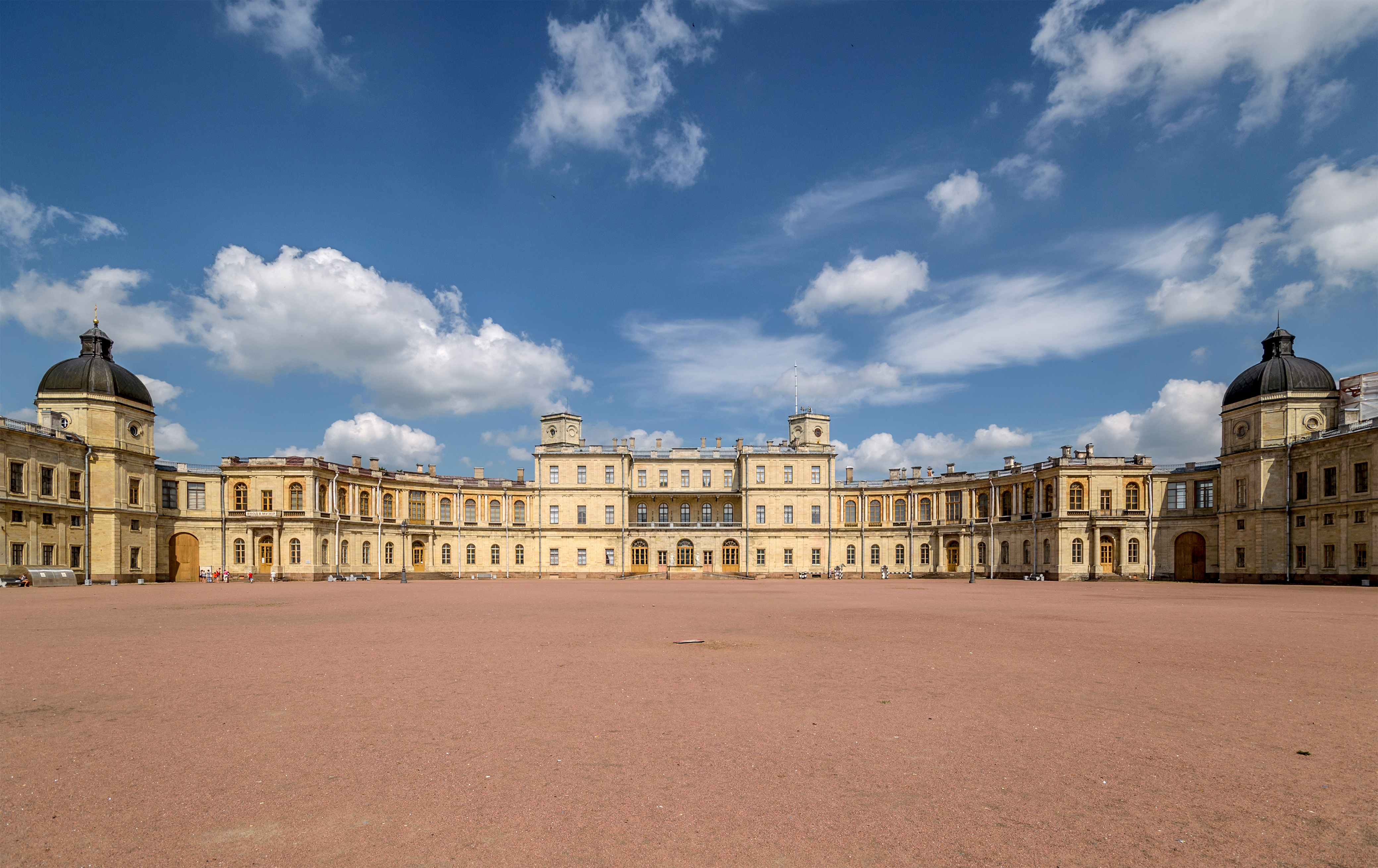
The town of Gatchina ( rus, Га́тчина, , ˈɡatːɕɪnə, links=y) serves as the administrative center of the Gatchinsky District in Leningrad Oblast, Russia. It lies south-south-west of St. Petersburg, along the E95 highway which links Saint Petersburg and Pskov. Population: It was previously known as ''Khotchino'', ''Gatchina'' (until February 14, 1923), ''Trotsk'' (until August 2, 1929), and ''Krasnogvardeysk'' (until January 28, 1944). Gatchina, the largest town in Leningrad Oblast, is best known as the location of the Great Gatchina Palace, one of the main residences of the Russian Imperial Family during the 18th and 19th centuries. The historic center and Gatchina Palace are part of the UNESCO World Heritage Site's "Historic Centre of Saint Petersburg and Related Groups of Monuments". Another popular tourist attraction in Gatchina is the Prioratsky Palace. Gatchina has placed highly in quality-of-life rankings in Russia. History Early ... [...More Info...] [...Related Items...] OR: [Wikipedia] [Google] [Baidu] |
Raion
A raion (also spelt rayon) is a type of administrative unit of several post-Soviet states. The term is used for both a type of subnational entity and a division of a city. The word is from the French (meaning 'honeycomb, department'), and is commonly translated as "district" in English. A raion is a standardized administrative entity across most of the former Soviet Union and is usually a subdivision two steps below the national level, such as a subdivision of an oblast. However, in smaller USSR republics, it could be the primary level of administrative division. After the fall of the Soviet Union, some of the republics kept the ''raion'' (e.g. Azerbaijan, Belarus, Ukraine, Russia, Moldova, Kazakhstan, Kyrgyzstan) while others dropped it (e.g. Georgia, Uzbekistan, Estonia, Lithuania, Latvia, Armenia, Tajikistan, Turkmenistan). In Bulgaria, it refers to an internal administrative subdivision of a city not related to the administrative division of the country as a whole, or, i ... [...More Info...] [...Related Items...] OR: [Wikipedia] [Google] [Baidu] |
Votians
Votians, also referred to as Votes, Vots and Vods ( vot, Vađđalaizõd, et, vadjalased) are a Finnic ethnic group native to historical Ingria, the part of modern-day northwestern Russia that is roughly southwest of Saint Petersburg and east of the Estonian border-town of Narva. The Finnic Votic language spoken by Votians is close to extinction. The language is still spoken in three villages of historical Votia and by an unknown number of speakers in the countryside. The villages are '' Jõgõperä'' (Krakolye), ''Liivcülä'' (Peski), and ''Luuditsa'' (Luzhitsy).Eesti Rahva Muuseum: Vadjalased Votians were one of the founding people of . History ) , la ...[...More Info...] [...Related Items...] OR: [Wikipedia] [Google] [Baidu] |
Izhorians
The Izhorians (russian: Ижо́ра; ижо́рцы; fi, inkerikot; et, isurid; sg. ''ižoralain'', ''inkeroin'', ''ižora'', ''ingermans'', ''ingers'', ''ingrian'', pl. ''ižoralaizet''), along with the Votes, are a Finnic indigenous people native to Ingria. Small numbers can still be found in the western part of Ingria, between the Narva and Neva rivers in northwestern Russia. Although in English oftentimes sharing a common name with the Finns of Ingria, these two groups are distinct from one another. History The history of the Izhorians is bound to the history of Ingria. It is supposed that shortly after 1000 AD the Izhorians moved from Karelia to the west and south-west. In 1478, the Novgorod Republic, where Ingrians had settled, was united with the Grand Duchy of Moscow, and some of the Izhorians were transferred to the east. The establishment of St Petersburg in 1703 had a great influence on Izhorian culture. World War II had the biggest impact on Izhorians, as dev ... [...More Info...] [...Related Items...] OR: [Wikipedia] [Google] [Baidu] |
Ingria
Ingria is a historical region in what is now northwestern European Russia. It lies along the southeastern shore of the Gulf of Finland, bordered by Lake Ladoga on the Karelian Isthmus in the north and by the River Narva on the border with Estonia in the west. The earliest known indigenous European peoples of the region are the now mostly Eastern Orthodox Izhorians and Votians, as well as the Ingrian Finns who descend from the Lutheran Finnish immigrants who settled in the area in the 17th century, when Finland proper and Ingria were both parts of the Swedish Empire. Ingria as a whole never formed a separate state, however North Ingria was an independent state for just under two years in 1919–1920. The Ingrians, understood as the inhabitants of Ingria regardless of ethnicity, can hardly be said to have been a nation, although the Soviet Union recognized their "nationality"; as an ethnic group, the Ingrians proper, Izhorians, are close to extinction together with their langua ... [...More Info...] [...Related Items...] OR: [Wikipedia] [Google] [Baidu] |
Natural Gas
Natural gas (also called fossil gas or simply gas) is a naturally occurring mixture of gaseous hydrocarbons consisting primarily of methane in addition to various smaller amounts of other higher alkanes. Low levels of trace gases like carbon dioxide, nitrogen, hydrogen sulfide, and helium are also usually present. Natural gas is colorless and odorless, so odorizers such as mercaptan (which smells like sulfur or rotten eggs) are commonly added to natural gas supplies for safety so that leaks can be readily detected. Natural gas is a fossil fuel and non-renewable resource that is formed when layers of organic matter (primarily marine microorganisms) decompose under anaerobic conditions and are subjected to intense heat and pressure underground over millions of years. The energy that the decayed organisms originally obtained from the sun via photosynthesis is stored as chemical energy within the molecules of methane and other hydrocarbons. Natural gas can be burned fo ... [...More Info...] [...Related Items...] OR: [Wikipedia] [Google] [Baidu] |
Karst Cave
Karst is a topography formed from the dissolution of soluble rocks such as limestone, dolomite, and gypsum. It is characterized by underground drainage systems with sinkholes and caves. It has also been documented for more weathering-resistant rocks, such as quartzite, given the right conditions. Subterranean drainage may limit surface water, with few to no rivers or lakes. However, in regions where the dissolved bedrock is covered (perhaps by debris) or confined by one or more superimposed non-soluble rock strata, distinctive karst features may occur only at subsurface levels and can be totally missing above ground. The study of ''paleokarst'' (buried karst in the stratigraphic column) is important in petroleum geology because as much as 50% of the world's hydrocarbon reserves are hosted in carbonate rock, and much of this is found in porous karst systems. Etymology The English word ''karst'' was borrowed from German in the late 19th century, which entered German much earlier. ... [...More Info...] [...Related Items...] OR: [Wikipedia] [Google] [Baidu] |
Karst
Karst is a topography formed from the dissolution of soluble rocks such as limestone, dolomite, and gypsum. It is characterized by underground drainage systems with sinkholes and caves. It has also been documented for more weathering-resistant rocks, such as quartzite, given the right conditions. Subterranean drainage may limit surface water, with few to no rivers or lakes. However, in regions where the dissolved bedrock is covered (perhaps by debris) or confined by one or more superimposed non-soluble rock strata, distinctive karst features may occur only at subsurface levels and can be totally missing above ground. The study of ''paleokarst'' (buried karst in the stratigraphic column) is important in petroleum geology because as much as 50% of the world's hydrocarbon reserves are hosted in carbonate rock, and much of this is found in porous karst systems. Etymology The English word ''karst'' was borrowed from German in the late 19th century, which entered German much earlier ... [...More Info...] [...Related Items...] OR: [Wikipedia] [Google] [Baidu] |
Dolomite (rock)
Dolomite (also known as dolomite rock, dolostone or dolomitic rock) is a sedimentary carbonate rock that contains a high percentage of the mineral dolomite, CaMg(CO3)2. It occurs widely, often in association with limestone and evaporites, though it is less abundant than limestone and rare in Cenozoic rock beds (beds less than about 66 million years in age). The first geologist to distinguish dolomite rock from limestone was Belsazar Hacquet in 1778. Most dolomite was formed as a magnesium replacement of limestone or of lime mud before lithification. The geological process of conversion of calcite to dolomite is known as dolomitization and any intermediate product is known as dolomitic limestone. The "dolomite problem" refers to the vast worldwide depositions of dolomite in the past geologic record in contrast to the limited amounts of dolomite formed in modern times. Recent research has revealed sulfate-reducing bacteria living in anoxic conditions precipitate dolomite which ind ... [...More Info...] [...Related Items...] OR: [Wikipedia] [Google] [Baidu] |
Limestone
Limestone ( calcium carbonate ) is a type of carbonate sedimentary rock which is the main source of the material lime. It is composed mostly of the minerals calcite and aragonite, which are different crystal forms of . Limestone forms when these minerals precipitate out of water containing dissolved calcium. This can take place through both biological and nonbiological processes, though biological processes, such as the accumulation of corals and shells in the sea, have likely been more important for the last 540 million years. Limestone often contains fossils which provide scientists with information on ancient environments and on the evolution of life. About 20% to 25% of sedimentary rock is carbonate rock, and most of this is limestone. The remaining carbonate rock is mostly dolomite, a closely related rock, which contains a high percentage of the mineral dolomite, . ''Magnesian limestone'' is an obsolete and poorly-defined term used variously for dolomite, for limes ... [...More Info...] [...Related Items...] OR: [Wikipedia] [Google] [Baidu] |


.jpg)
