|
Bircotes
Bircotes is an area in the civil parish of Harworth Bircotes (with Harworth) in the Bassetlaw district of Nottinghamshire, England on the border with South Yorkshire. The population of the civil parish was 7,948. The local school in the area is Serlby Park Academy. Bircotes was founded in the 1920s, with the discovery of coal during the First World War and the establishment of Harworth Colliery Harworth Colliery was a colliery near the town of Harworth Bircotes in Bassetlaw, Nottinghamshire, England. It was abandoned in 2006 due to troubles at the seam. UK Coal, who owned and maintained the mine, were waiting for a contract to make ... (which has since closed), to provide homes for miners. It was home to one of the last deep-mine pits in the UK. See also * RAF Bircotes References External links Villages in Nottinghamshire Bassetlaw District {{Nottinghamshire-geo-stub ... [...More Info...] [...Related Items...] OR: [Wikipedia] [Google] [Baidu] |
RAF Bircotes
Royal Air Force Bircotes or more simply RAF Bircotes is a former Royal Air Force satellite airfield located within South Yorkshire, England. Although it was named after the town of Bircotes which is in Nottinghamshire. History RAF Bircotes was located next the No. 1 Group RAF, RAF Bomber Command HQ at RAF Bawtry, Bawtry Hall, Bawtry, England. The airfield consisted of a grass strip with a connecting perimeter track with T2, B1 and Bessonneau hangars plus other miscellaneous buildings. The Airfield opened in late 1941 and was used by the Avro Ansons, Vickers Wellingtons, and Avro Manchesters from No. 25 Operational Training Unit RAF (OTU) at nearby RAF Finningley. A variety of training units occupied the airfield including two operational Training units: * Satellite for No. 18 OTU (March 1943 - November 1944) * Satellite for No. 28 OTU (June - July 1944) * Satellite for No. 82 OTU (August - October 1943) * Satellite for No. 16 (Polish) Service Flying Training School ... [...More Info...] [...Related Items...] OR: [Wikipedia] [Google] [Baidu] |
Harworth Bircotes
Harworth Bircotes or Harworth and Bircotes is a town and civil parish in the Bassetlaw district of Nottinghamshire in the East Midlands of England. The parish includes the settlements of Bircotes and Harworth Harworth is an area in the civil parish of Harworth Bircotes (with Bircotes) in the Bassetlaw district in Nottinghamshire, England. It is approximately north of Worksop. The population of the civil parish was 7,948 in the 2011 Census. Hist .... The parish was created on 1 April 1974 out of Harworth parish. Harworth and Bircotes Town Council is the lowest tier of local government. References External linksHarworth Colliery - Miner's Advice Information Template [...More Info...] [...Related Items...] OR: [Wikipedia] [Google] [Baidu] |
Harworth
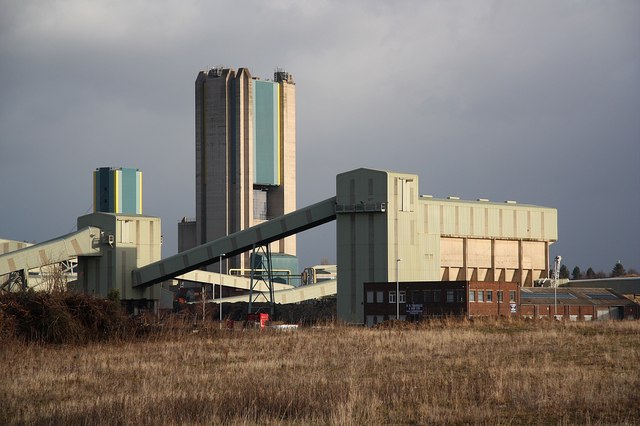
Harworth is an area in the civil parish of Harworth Bircotes (with Bircotes) in the Bassetlaw district in Nottinghamshire, England. It is approximately north of Worksop. The population of the civil parish was 7,948 in the 2011 Census. History The Harworth coal mine opened in 1921 and produced coal for the power stations on the River Trent. A new pit tower was built in 1989 when the pit was at its peak of production but seven years later the colliery was 'mothballed'. In 2015, it was announced that the pit tower would be demolished and the colliery site would be redeveloped for housing which has since been completed. The former freight line and sidings into the colliery have been lifted and left undeveloped. The local football team is called Harworth Colliery F.C. Etymology The town's name is from Old English ''har'' "grey" (compare modern hoary") and ''worth'' (also ''worō'', ''worþ'') "enclosure". Harworth was recorded in the Domesday Book as ''Hareworde''. Notable ... [...More Info...] [...Related Items...] OR: [Wikipedia] [Google] [Baidu] |
Bassetlaw District
Bassetlaw is a local government district in Nottinghamshire, England. The district has four towns: Worksop, Tuxford, Harworth Bircotes and Retford. It is bounded to the north by the Metropolitan Boroughs of Doncaster and Rotherham, the east by West Lindsey, the west by both the Borough of Chesterfield and North East Derbyshire and the south by Mansfield District and Newark and Sherwood. The district is along with Bolsover District, North East Derbyshire and Borough of Chesterfield is a non-constituent member of the Sheffield City Region. History Bassetlaw was created as a non-metropolitan district in 1974 by the merger of the municipal boroughs of Worksop and East Retford and most of Worksop Rural District and East Retford Rural District following the passage of the Local Government Act 1972. Local Government in Nottinghamshire is organised on a two-tier basis, with local district councils such as Bassetlaw District Council responsible for local services suc ... [...More Info...] [...Related Items...] OR: [Wikipedia] [Google] [Baidu] |
Serlby Park Academy
Serlby Park Academy is a mixed all-through school and sixth form located in the twin villages of Bircotes and Harworth in North Nottinghamshire. The school also serves the nearby towns of Serlby, Styrrup, Blyth, Misson, among others. It is part of the Delta Academies Trust, along with several other schools and academies in the area. Facilities As of 2016, the school operates from one purpose built site containing all students from infant and nursery (ages 3–7), primary (ages 7–11), and secondary (ages 11–16) stages of education. Serlby Park is also part of (and one of the sites making up) the Doncaster Collegiate Sixth Form, which provides the education provision for students aged 16–18. Academic performance OFSTED currently rates this school "Good", noting that at the moment the school has 831 registered pupils, with capacity for up to 1230. History The school was established in September 2005 as a result of the amalgamation of three schools Bircotes and Harwor ... [...More Info...] [...Related Items...] OR: [Wikipedia] [Google] [Baidu] |
Nottinghamshire
Nottinghamshire (; abbreviated Notts.) is a landlocked county in the East Midlands region of England, bordering South Yorkshire to the north-west, Lincolnshire to the east, Leicestershire to the south, and Derbyshire to the west. The traditional county town is Nottingham, though the county council is based at County Hall in West Bridgford in the borough of Rushcliffe, at a site facing Nottingham over the River Trent. The districts of Nottinghamshire are Ashfield, Bassetlaw, Broxtowe, Gedling, Mansfield, Newark and Sherwood, and Rushcliffe. The City of Nottingham was administratively part of Nottinghamshire between 1974 and 1998, but is now a unitary authority, remaining part of Nottinghamshire for ceremonial purposes. The county saw a minor change in its coverage as Finningley was moved from the county into South Yorkshire and is part of the City of Doncaster. This is also where the now-closed Doncaster Sheffield Airport is located (formerly Robin Hood Airport) ... [...More Info...] [...Related Items...] OR: [Wikipedia] [Google] [Baidu] |
Harworth Colliery
Harworth Colliery was a colliery near the town of Harworth Bircotes in Bassetlaw, Nottinghamshire, England. It was abandoned in 2006 due to troubles at the seam. UK Coal, who owned and maintained the mine, were waiting for a contract to make it worth investing money to open up a new seam. Bassetlaw has at the moment no working pits; the nearest was Maltby Main Colliery in South Yorkshire which closed in 2013. The mothballing of the pit in 2006 brought an end to 86 years of mining in Bassetlaw. The area has since been redeveloped for retail, industrial and residential. History Work began on sinking the shaft in 1913, when the Northern Union Mining Company was set up. This was with an investment in German equipment and men, but with the start of the First World War (1914-1918) the German workers were interned and the company's assets were impounded by the Government, and so construction was halted. Later in 1917 the pit was bought by Messrs. Barber, Walker & Co. for £80,10 ... [...More Info...] [...Related Items...] OR: [Wikipedia] [Google] [Baidu] |
Bassetlaw (UK Parliament Constituency)
Bassetlaw is a parliamentary constituency in Nottinghamshire, represented in the House of Commons of the UK Parliament since the 2019 general election by Brendan Clarke-Smith, a Conservative. Before that election, the seat had been part of the so-called " red wall", being held by the Labour Party since 1929. Constituency profile The Bassetlaw constituency is mostly rural and covers the north of Nottinghamshire, including the towns of Worksop and Retford. It shares the name with the Bassetlaw district. Parts of the constituency are former coal mining areas. Residents' health and wealth are slightly below the UK average. Boundaries The constituency includes 22 electoral wards from Bassetlaw District Council: *Beckingham, Blyth, Carlton, Clayworth, East Retford East, East Retford North, East Retford South, East Retford West, Everton, Harworth, Langold, Misterton, Ranskill, Sturton, Sutton, Welbeck, Worksop East, Worksop North, Worksop North East, Works ... [...More Info...] [...Related Items...] OR: [Wikipedia] [Google] [Baidu] |
South Yorkshire
South Yorkshire is a ceremonial and metropolitan county in the Yorkshire and Humber Region of England. The county has four council areas which are the cities of Doncaster and Sheffield as well as the boroughs of Barnsley and Rotherham. In Northern England, it is on the east side of the Pennines. Part of the Peak District national park is in the county. The River Don flows through most of the county, which is landlocked. The county had a population of 1.34 million in 2011. Sheffield largest urban centre in the county, it is the south west of the county. The built-up area around Sheffield and Rotherham, with over half the county's population living within it, is the tenth most populous in the United Kingdom. The majority of the county was formerly governed as part of the county of Yorkshire, the former county remains as a cultural region. The county was created on 1 April 1974, under the Local Government Act 1972. It was created from 32 local government districts o ... [...More Info...] [...Related Items...] OR: [Wikipedia] [Google] [Baidu] |
First World War
World War I (28 July 1914 11 November 1918), often abbreviated as WWI, was one of the deadliest global conflicts in history. Belligerents included much of Europe, the Russian Empire, the United States, and the Ottoman Empire, with fighting occurring throughout Europe, the Middle East, Africa, the Pacific, and parts of Asia. An estimated 9 million soldiers were killed in combat, plus another 23 million wounded, while 5 million civilians died as a result of military action, hunger, and disease. Millions more died in genocides within the Ottoman Empire and in the 1918 influenza pandemic, which was exacerbated by the movement of combatants during the war. Prior to 1914, the European great powers were divided between the Triple Entente (comprising France, Russia, and Britain) and the Triple Alliance (containing Germany, Austria-Hungary, and Italy). Tensions in the Balkans came to a head on 28 June 1914, following the assassination of Arch ... [...More Info...] [...Related Items...] OR: [Wikipedia] [Google] [Baidu] |
Villages In Nottinghamshire
A village is a clustered human settlement or community, larger than a hamlet but smaller than a town (although the word is often used to describe both hamlets and smaller towns), with a population typically ranging from a few hundred to a few thousand. Though villages are often located in rural areas, the term urban village is also applied to certain urban neighborhoods. Villages are normally permanent, with fixed dwellings; however, transient villages can occur. Further, the dwellings of a village are fairly close to one another, not scattered broadly over the landscape, as a dispersed settlement. In the past, villages were a usual form of community for societies that practice subsistence agriculture, and also for some non-agricultural societies. In Great Britain, a hamlet earned the right to be called a village when it built a church. [...More Info...] [...Related Items...] OR: [Wikipedia] [Google] [Baidu] |


