|
Batek Island
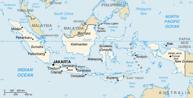
Batek Island or Fatu Sinai is a small uninhabited island located in the Savu Sea, northwest of the island of Timor, off the East Timorese municipality of Oecusse. The sovereignty of the island is disputed between Indonesia and East Timor.GMN TV''Xanana aprezenta progresu negosiasaun fronteira marítima no terrestre ba PN'', 21 January 2022 It is 530 meters long and 420 meters wide, for an area of 13.5 hectares. Its highest point is fifty meters above sea level. East Timor is claiming the island, using a map of 1914 as reference. In 2004, Indonesian Colonel Moesanip said that this claim was abandoned when the East Timorese Minister of Foreign Affairs, José Ramos-Horta, recognized Indonesian sovereignty over the island."Batek island belongs to Indonesia, E Timor FM says", Antara, 18 août 2004. However, East Timorese chief negotiator Xanana Gusmão José Alexandre "Xanana" Gusmão (; born 20 June 1946) is an East Timorese politician. A former rebel, he was the third Presid ... [...More Info...] [...Related Items...] OR: [Wikipedia] [Google] [Baidu] |
Timor
Timor is an island at the southern end of Maritime Southeast Asia, in the north of the Timor Sea. The island is East Timor–Indonesia border, divided between the sovereign states of East Timor on the eastern part and Indonesia on the western part. The Indonesian part, also known as West Timor, constitutes part of the Provinces of Indonesia, province of East Nusa Tenggara. Within West Timor lies an exclave of East Timor called Oecusse District. The island covers an area of . The name is a variant of ''timur'', Malay language, Malay for "east"; it is so called because it lies at the eastern end of the Lesser Sunda Islands. Mainland Australia is less than 500 km away, separated by the Timor Sea. Language, ethnic groups and religion Anthropologists identify eleven distinct Ethnolinguistic group, ethno-linguistic groups in Timor. The largest are the Atoni of western Timor and the Tetum of central and eastern Timor. Most indigenous Timorese languages belong to the Timor� ... [...More Info...] [...Related Items...] OR: [Wikipedia] [Google] [Baidu] |
Savu Sea
The Savu Sea (or the Sawu Sea) ( id, Laut Sawu, pt, Mar de Savu, tet, Tasi Savu) is a small sea within Indonesia named for the island of Savu (Sawu) on its southern boundary. It is bounded by Savu and Rai Jua to the south, the islands of Rote and Timor (split between East Timor and Indonesia) to the east, Flores and the Alor archipelago to the north/northwest, and the island of Sumba to the west/northwest. Between these islands, it flows into the Indian Ocean to the south and west, the Flores Sea to the north, and the Banda Sea to the northeast. The Savu Sea reaches about in depth. It spans about 600 km from west to east, and 200 km from north to south. The largest city on the sea is Kupang, the capital of East Nusa Tenggara province on the island of Timor, with about 450,000 inhabitants. Extent The International Hydrographic Organization (IHO) defines the Savu Sea as being one of the waters of the East Indian Archipelago. The IHO defines its limits as foll ... [...More Info...] [...Related Items...] OR: [Wikipedia] [Google] [Baidu] |
Indonesia
Indonesia, officially the Republic of Indonesia, is a country in Southeast Asia and Oceania between the Indian and Pacific oceans. It consists of over 17,000 islands, including Sumatra, Java, Sulawesi, and parts of Borneo and New Guinea. Indonesia is the world's largest archipelagic state and the 14th-largest country by area, at . With over 275 million people, Indonesia is the world's fourth-most populous country and the most populous Muslim-majority country. Java, the world's most populous island, is home to more than half of the country's population. Indonesia is a presidential republic with an elected legislature. It has 38 provinces, of which nine have special status. The country's capital, Jakarta, is the world's second-most populous urban area. Indonesia shares land borders with Papua New Guinea, East Timor, and the eastern part of Malaysia, as well as maritime borders with Singapore, Vietnam, Thailand, the Philippines, Australia, Palau, and India ... [...More Info...] [...Related Items...] OR: [Wikipedia] [Google] [Baidu] |
East Timor
East Timor (), also known as Timor-Leste (), officially the Democratic Republic of Timor-Leste, is an island country in Southeast Asia. It comprises the eastern half of the island of Timor, the exclave of Oecusse on the island's north-western half, and the minor islands of Atauro and Jaco. Australia is the country's southern neighbour, separated by the Timor Sea. The country's size is . Dili is its capital and largest city. East Timor came under Portuguese influence in the sixteenth century, remaining a Portuguese colony until 1975. Internal conflict preceded a unilateral declaration of independence and an Indonesian invasion and annexation. Resistance continued throughout Indonesian rule, and in 1999 a United Nations–sponsored act of self-determination led to Indonesia relinquishing control of the territory. On 20 May 2002, as ''Timor-Leste'', it became the first new sovereign state of the 21st century. The national government runs on a semi-presidential system, w ... [...More Info...] [...Related Items...] OR: [Wikipedia] [Google] [Baidu] |
Municipalities Of East Timor
A municipality is usually a single administrative division having municipal corporation, corporate status and powers of self-government or jurisdiction as granted by national and regional laws to which it is subordinate. The term ''municipality'' may also mean the governing body of a given municipality. A municipality is a general-purpose administrative subdivision, as opposed to a special district (United States), special-purpose district. The term is derived from French language, French and Latin language, Latin . The English language, English word ''municipality'' derives from the Latin social contract (derived from a word meaning "duty holders"), referring to the Latin communities that supplied Rome with troops in exchange for their own incorporation into the Roman state (granting Roman citizenship to the inhabitants) while permitting the communities to retain their own local governments (a limited autonomy). A municipality can be any political jurisdiction (area), jurisd ... [...More Info...] [...Related Items...] OR: [Wikipedia] [Google] [Baidu] |
Oecusse
Oecusse (also variously ''Oecussi'', ''Ocussi'', ''Oekussi'', ''Oekusi'', ''Okusi'', ''Oé-Cusse''), also known as Oecusse-Ambeno (; ) and formerly just Ambeno, officially the Special Administrative Region Oecusse-Ambeno (), is an exclave, municipality (formerly a district) and the only Special Administrative Region (SAR) of East Timor. Located on the north coast of the western portion of Timor, Oecusse is separated from the rest of East Timor by West Timor, Indonesia, which is part of the province of East Nusa Tenggara. West Timor surrounds Oecusse on all sides except the north, where the exclave faces the Savu Sea. The capital of Oecusse is Pante Macassar, also called ''Oecussi Town'', or formerly, in Portuguese Timor, ''Vila Taveiro''. Originally ''Ambeno'' was the name of the former district and ''Oecussi'' its capital. Etymology ''Oecusse'' is the traditional name of Pante Macassar, the present day capital of the Special Administrative Region, and its environs. The loc ... [...More Info...] [...Related Items...] OR: [Wikipedia] [Google] [Baidu] |
José Ramos-Horta
José Manuel Ramos-Horta (; born 26 December 1949) is an East Timorese politician currently serving as president of East Timor since May 2022. He previously served as president from 20 May 2007 to 20 May 2012. Previously he was Minister of Foreign Affairs from 2002 to 2006 and Prime Minister from 2006 to 2007. He is a co-recipient of the 1996 Nobel Peace Prize, along with Carlos Filipe Ximenes Belo, for working "towards a just and peaceful solution to the conflict in East Timor". As a founder and former member of Fretilin, Ramos-Horta served as the exiled spokesman for the East Timorese resistance during the years of the Indonesian occupation of East Timor (1975–1999). While he continued to work with Fretilin, Ramos-Horta resigned from the party in 1988, becoming an independent politician. After East Timor achieved independence in 2002, Ramos-Horta was appointed as the country's first foreign minister. He served in this position until his resignation on 25 June 2006, amidst ... [...More Info...] [...Related Items...] OR: [Wikipedia] [Google] [Baidu] |
Xanana Gusmão
José Alexandre "Xanana" Gusmão (; born 20 June 1946) is an East Timorese politician. A former rebel, he was the third President of the independent East Timor, serving from 2002 to 2007. He then became its fourth prime minister, serving from 2007"Gusmao sworn in as East Timor PM" , Al Jazeera, 8 August 2007. to 2015. Gusmão holds the office of Minister of Planning and Strategic Investment since stepping down as PM. Early life and career Gusmão was born in , in what was then , to parents of mixed Portu ...[...More Info...] [...Related Items...] OR: [Wikipedia] [Google] [Baidu] |
Islands Of Indonesia
The islands of Indonesia, also known as the Indonesian Archipelago ( id, Kepulauan Indonesia) or Nusantara, may refer either to the islands comprising the country of Indonesia or to the geographical groups which include its islands. History The exact number of islands comprising Indonesia varies among definitions and sources. According to the Law No 9/1996 on Maritime Territory of Indonesia, of 17,508 officially listed islands within the territory of the Republic of Indonesia. According to a geospatial survey conducted between 2007 and 2010 by the National Coordinating Agency for Survey and Mapping (Bakorsurtanal), Indonesia has 13,466 islands. However, according to earlier survey in 2002 by National Institute of Aeronautics and Space (LAPAN), the Indonesian archipelago has 18,307 islands, and according to the CIA ''World Factbook'', there are 17,508 islands. The discrepancy of the numbers of Indonesian islands was because that the earlier surveys include "tidal islands"; s ... [...More Info...] [...Related Items...] OR: [Wikipedia] [Google] [Baidu] |
Islands Of East Timor
An island or isle is a piece of subcontinental land completely surrounded by water. Very small islands such as emergent land features on atolls can be called islets, skerries, cays or keys. An island in a river or a lake island may be called an eyot or ait, and a small island off the coast may be called a holm. Sedimentary islands in the Ganges Delta are called chars. A grouping of geographically or geologically related islands, such as the Philippines, is referred to as an archipelago. There are two main types of islands in the sea: continental islands and oceanic islands. There are also artificial islands (man-made islands). There are about 900,000 official islands in the world. This number consists of all the officially-reported islands of each country. The total number of islands in the world is unknown. There may be hundreds of thousands of tiny islands that are unknown and uncounted. The number of sea islands in the world is estimated to be more than 200,000. The to ... [...More Info...] [...Related Items...] OR: [Wikipedia] [Google] [Baidu] |
Landforms Of East Nusa Tenggara
A landform is a natural or anthropogenic land feature on the solid surface of the Earth or other planetary body. Landforms together make up a given terrain, and their arrangement in the landscape is known as topography. Landforms include hills, mountains, canyons, and valleys, as well as shoreline features such as bays, peninsulas, and seas, including submerged features such as mid-ocean ridges, volcanoes, and the great ocean basins. Physical characteristics Landforms are categorized by characteristic physical attributes such as elevation, slope, orientation, stratification, rock exposure and soil type. Gross physical features or landforms include intuitive elements such as berms, mounds, hills, ridges, cliffs, valleys, rivers, peninsulas, volcanoes, and numerous other structural and size-scaled (e.g. ponds vs. lakes, hills vs. mountains) elements including various kinds of inland and oceanic waterbodies and sub-surface features. Mountains, hills, plateaux, and plains are t ... [...More Info...] [...Related Items...] OR: [Wikipedia] [Google] [Baidu] |


.jpg)