|
Balsas, Maranhão
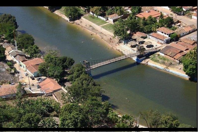
Balsas () is a city in the state of Maranhão, northeast Brazil. It is located in southern Maranhão, 800 km from the capital of the state, São Luís, Maranhão, São Luís. Geography Balsas covers an area of 13,141.64 km2, being the largest municipality in Maranhão. The median elevation of the city is 283 meters (810 ft). Climate Balsas has a Savanna tropical climate. Temperature is hot from April through October. It rains from November through March. Vegetation Cerrado is the typical vegetation of the area. However, due to the advance of agricultural activities, the ecosystems is threatened. Hydrography There are many streams and rivers in the municipality, but the most important is Das Balsas River (Maranhão), Rio Balsas, which crosses the city. Demographics According to 2001 census, Balsas has 60,613 inhabitants. 82.73% live in Urban areas. The infant mortality rate is 35.1 deaths /1,000 live births and life expectancy is 64.1 years. The a ... [...More Info...] [...Related Items...] OR: [Wikipedia] [Google] [Baidu] |
Time In Brazil
Time in Brazil is calculated using standard time, and the country (including its offshore islands) is divided into four standard time zones: Fernando de Noronha time (UTC−02:00), Brasília time (UTC−03:00), Amazon time (UTC−04:00), and Acre time (UTC−05:00). About 93% of the Brazilian population live in Brasília time (UTC−03:00). Time zones Fernando de Noronha time (UTC−02:00) This is the standard time zone only on a few small offshore Atlantic islands. The only such island with a permanent population is Fernando de Noronha, with 3,167 inhabitants (2022 census), 0.0016% of Brazil's population. The other islands ( Trindade and Martim Vaz, Rocas Atoll and Saint Peter and Saint Paul Archipelago) either are totally uninhabited or have small seasonally rotating Brazilian Navy garrisons or teams of scientists. Brasília time (UTC−03:00) The main time zone of Brazil comprises the states in the South, Southeast and Northeast regions (except the small islan ... [...More Info...] [...Related Items...] OR: [Wikipedia] [Google] [Baidu] |
Roman Catholic Diocese Of Balsas
The Roman Catholic Diocese of Balsas () is a diocese located in the city of Balsas in the ecclesiastical province An ecclesiastical province is one of the basic forms of jurisdiction in Christian churches, including those of both Western Christianity and Eastern Christianity, that have traditional hierarchical structures. An ecclesiastical province consist ... of São Luís do Maranhão in Brazil. History * 20 December 1954: Established as Territorial Prelature of Santo Antônio de Balsas from the Diocese of Caxias do Maranhão * 26 October 1981: Promoted as Diocese of Balsas Bishops ;Prelates of Santo Antônio de Balsas * Diego Parodi, M.C.C.I. (1959.05.09 – 1966) *Rino Carlesi, M.C.C.I. (1967.01.12 1981.10.25) ;Bishops of Balsas * Rino Carlesi, M.C.C.I. (1981.10.25 – 1998.04.15) * Gianfranco Masserdotti, M.C.C.I. (1998.04.15 – 2006.09.17) ** Coadjutor bishop 1995–1998 * Enemésio Ângelo Lazzaris, F.D.P. (2007.12.12 – 2020.02.02) * Valentim Fagundes de Me ... [...More Info...] [...Related Items...] OR: [Wikipedia] [Google] [Baidu] |
Balsas Riobalsas
Balsas may refer to: Places * Balsas, Maranhão, Brazil * Balsas, Ecuador ** Balsas Canton * Balsas District, Chachapoyas Province, Peru * Balsas, Guerrero, Mexico Rivers * Balsas River, in Mexico * Balsas River (Panama) * Das Balsas River (other) Other uses * ''Balsas'' (plant), a genus of the Sapindoideae flowering plants * Balsa (ship) A balsa is a boat or ship built by various pre-Columbian South American civilizations constructed from woven reeds of the totora bulrush. They varied in size from small canoe sized personal fishing boats to large ships up to 30 metres long. They ..., reed boats or ships of pre-Columbian South American civilizations See also * Balsa (other) * Balsas dry forests, in Mexico {{disambiguation, geo ... [...More Info...] [...Related Items...] OR: [Wikipedia] [Google] [Baidu] |
Cerrado
The Cerrado () is a vast ecoregion of Tropics, tropical savanna in central Brazil, being present in the states of Goiás, Mato Grosso do Sul, Mato Grosso, Tocantins, Maranhão, Piauí, Bahia, Minas Gerais, São Paulo (state), São Paulo, Paraná (state), Paraná and the Federal District (Brazil), Federal District. The core areas of the Cerrado biome are the Brazilian highlands – the ''Planalto''. The main habitat types of the Cerrado consist of forest savanna, wooded savanna, park savanna and grass, gramineous-woody savanna. The Cerrado also includes savanna wetlands and gallery forests. The second largest of Biomes in Brazil, Brazil's major habitat types, after the Amazon rainforest, Amazonian rainforest, the Cerrado accounts for a full 21 percent of the country's land area (extending marginally into Paraguay and Bolivia). About 75% of the Cerrado’s 2 million km2 is privately owned. Vast amounts of research have shown that the Cerrado is one of the richest of all tropi ... [...More Info...] [...Related Items...] OR: [Wikipedia] [Google] [Baidu] |
São Luís, Maranhão
São Luís (; "Saint Louis") is the capital and largest city of the Brazilian state of Maranhão. The city is located on Upaon-açu Island or Ilha de São Luís, in the Baía de São Marcos (''Saint Mark's Bay''), an extension of the Atlantic Ocean which forms the estuary of Pindaré, Mearim, Itapecuru and other rivers. Its coordinates are 2.53° south, 44.30° west. São Luís has the second largest maritime extension within Brazilian states. Its maritime extension is 640 km (397 miles). The city proper has a population of some 1,037,775 people (2022 IBGE census). The metropolitan area totals 1,536,017, ranked as the 15th largest in Brazil. São Luís, created originally as ''Saint-Louis-de-Maragnan'', is the only Brazilian state capital founded by France (see France Équinoxiale) and it is one of the three Brazilian state capitals located on islands (the others are Vitória and Florianópolis). The historic center of the city (dating from the 17th century) has ... [...More Info...] [...Related Items...] OR: [Wikipedia] [Google] [Baidu] |
UNDP
The United Nations Development Programme (UNDP) is a United Nations agency tasked with helping countries eliminate poverty and achieve sustainable economic growth and human development. The UNDP emphasizes on developing local capacity towards long-term self-sufficiency and prosperity. Based at the headquarters of the United Nations in New York City, it is the largest UN development aid agency, with offices in 177 countries. The UNDP is funded entirely by voluntary contributions from UN member states. Founding The UNDP was founded on 22 November 1965 through the merger of the Expanded Programme of Technical Assistance (EPTA) and the Special Fund in 1958. The rationale was to "avoid duplication of heiractivities". The EPTA was set up in 1949 to support the economic and political aspects of underdeveloped countries while the Special Fund was to enlarge the scope of UN technical assistance. The Special Fund arose from the idea of a Special United Nations Fund for Economic D ... [...More Info...] [...Related Items...] OR: [Wikipedia] [Google] [Baidu] |
Human Development Index
The Human Development Index (HDI) is a statistical composite index of life expectancy, Education Index, education (mean years of schooling completed and expected years of schooling upon entering the education system), and per capita income indicators, which is used to rank countries into four tiers of Human development (humanity), human development. A country scores a higher level of HDI when the life expectancy at birth, lifespan is higher, the education level is higher, and the gross national income GNI (PPP) per capita is higher. It was developed by Pakistani economist Mahbub ul-Haq and was further used to measure a country's development by the United Nations Development Programme (UNDP)'s Human Development Report Office. The 2010 Human Development Report introduced an List of countries by inequality-adjusted Human Development Index, inequality-adjusted Human Development Index (IHDI). While the simple HDI remains useful, it stated that "the IHDI is the actual level of huma ... [...More Info...] [...Related Items...] OR: [Wikipedia] [Google] [Baidu] |
Brazilian Institute Of Geography And Statistics
The Brazilian Institute of Geography and Statistics (; IBGE) is the agency responsible for official collection of statistical, geographic, cartographic, geodetic and environmental information in Brazil. IBGE performs a decennial national census; questionnaires account for information such as age, household income, literacy, education, occupation and hygiene levels. IBGE is a public institute created in 1936 under the name ''National Institute of Statistics''. Its founder and chief proponent was statistician Mário Augusto Teixeira de Freitas. The current name dates from 1938. Its headquarters are located in Rio de Janeiro, and its current president is Marcio Pochmann, replacing Eduardo Rios Neto. It was made a federal agency by Decree-Law No. 161 on February 13, 1967, and is linked to the Ministry of the Economy, inside the Secretariat of Planning, Budget and Management. Structure IBGE has a network of national research and dissemination components, comprising: * 27 ... [...More Info...] [...Related Items...] OR: [Wikipedia] [Google] [Baidu] |
Maranhão
Maranhão () is a States of Brazil, state in Brazil. Located in the country's Northeast Region, Brazil, Northeast Region, it has a population of about 7 million and an area of and it is divided into 217 municipalities. Clockwise from north, it borders on the Atlantic Ocean for 2,243 km and the states of Piauí, Tocantins and Pará. The people of Maranhão have a distinctive accent within the common Northeastern Brazilian dialect. Maranhão is described in literary works such as ''Canção do exílio, Exile Song'' by Gonçalves Dias and ''Casa de Pensão'' by Aluísio Azevedo. The dunes of Lençóis Maranhenses National Park, Lençóis are an important area of environmental preservation. Also of interest is the state capital of São Luís, Maranhão, São Luís, which is a UNESCO World Heritage Site. Another important conservation area is the Parnaíba River delta, between the states of Maranhão and Piauí, with its lagoons, desert dunes and deserted beaches or islands, suc ... [...More Info...] [...Related Items...] OR: [Wikipedia] [Google] [Baidu] |
Democratic Labour Party (Brazil)
The Democratic Labour Party (, PDT) is a political party in Brazil. History The Democratic Labour Party (PDT) was founded in 1979 by left-wing leader Leonel Brizola as an attempt to reorganise the Brazilian left-wing forces during the end of the Brazilian military dictatorship. Many of its members, including Brizola, had been active in the historical Brazilian Labour Party prior to the 1964 coup, which drove into exile or assassinated a number of its prominent members including ousted President João Goulart. Returning from exile in Uruguay, Brizola originally wanted to reclaim the PTB name for his party, but the military government awarded it to a more moderate grouping led by Ivete Vargas, leading to PDT being formed by a large majority of historical PTB members a week later. The PDT joined the Socialist International in 1986. It was the major left-wing party in Brazil until the rise of the Workers' Party (PT) in 1994. The Socialist Youth, founded in 1981, was original ... [...More Info...] [...Related Items...] OR: [Wikipedia] [Google] [Baidu] |
Mayor
In many countries, a mayor is the highest-ranking official in a Municipal corporation, municipal government such as that of a city or a town. Worldwide, there is a wide variance in local laws and customs regarding the powers and responsibilities of a mayor as well as the means by which a mayor is elected or otherwise mandated. Depending on the system chosen, a mayor may be the chief executive officer of the municipal government, may simply chair a multi-member governing body with little or no independent power, or may play a solely ceremonial role. A mayor's duties and responsibilities may be to appoint and oversee municipal managers and employees, provide basic governmental services to constituents, and execute the laws and ordinances passed by a municipal governing body (or mandated by a state, territorial or national governing body). Options for selection of a mayor include direct election by the public, or selection by an elected governing council or board. The term ''mayor ... [...More Info...] [...Related Items...] OR: [Wikipedia] [Google] [Baidu] |


