|
Amsterdam-West
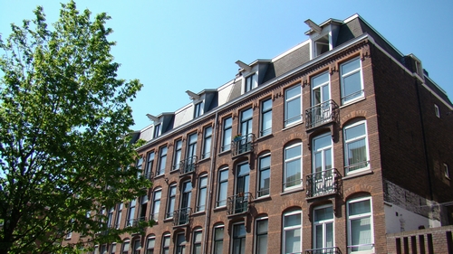
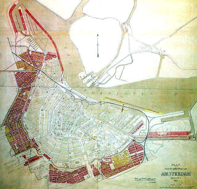
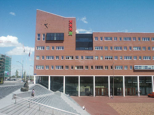
Amsterdam-West () is a borough (Dutch: ''stadsdeel'') of Amsterdam, Netherlands, to the west of the centre of the city. This borough was formed in 2010 through the merging of four former boroughs Oud West, Westerpark, De Baarsjes and Bos en Lommer. This part of Amsterdam was built roughly between the end of the 19th century and 1960. In 2013, the borough had approximately 142,700 inhabitants. With about 14,000 inhabitants per km2, West is also the most densely populated borough of Amsterdam. History The borough of Amsterdam-West consists primarily of the pre-World War II part of Amsterdam to the west of the Singelgracht. The western expansion beyond the 17th-century Amsterdam canal belt started in the last quarter of the 19th century. The first neighborhoods to be built were Spaarndammerbuurt, parts of Zeeheldenbuurt, Staatsliedenbuurt, Kinkerbuurt and Overtoombuurt. These neighborhoods are characterised by ''revolutiebouw'' (literally: 'revolution architecture'): quickly a ... [...More Info...] [...Related Items...] OR: [Wikipedia] [Google] [Baidu] |
De Baarsjes
De Baarsjes () is a district ( nl, wijk) in Amsterdam-West situated west of the city center of Amsterdam, Netherlands. Named after a former hamlet, urban development started in the 1920s. It contains the neighbourhoods Admiralenbuurt, Chassébuurt, Postjesbuurt, and Trompbuurt. Etymology The name comes from the former hamlet De Baarsjes (The Little Perches) that was formed in the 17th century, which in turn derived its name from an inn called De Drie Baarsjes (The Three Little Perches) situated on the eastern border of the present-day district. History Built during the first half of the 20th century along a tram line that brought commuters to the city centre, De Baarsjes was formulated by the architect Hendrik Petrus Berlage who designed the main square Mercatorplein. In 1990, De Baarsjes became a borough ( nl, stadsdeel) of Amsterdam. As it was mostly built before World War II, it was all built to last so when it came to urban renewal in the 1990s, most buildings were ... [...More Info...] [...Related Items...] OR: [Wikipedia] [Google] [Baidu] |
Amsterdam Oud-West
Oud-West is a neighborhood of Amsterdam, Netherlands, roughly covering the area between the Overtoom, a major thoroughfare west of the city centre, and the parallel De Clercqstraat, a shopping street. The exact boundaries are the Vondelpark and the Singelgracht, Hugo de Grootgracht and Kostverlorenvaart canals. The neighbourhood consists of two historically and demographically distinct communities: the Overtoombuurt in the south and the Kinkerbuurt in the north. Oud-West was a separate borough of Amsterdam until the 2010 borough reforms, when it merged with the boroughs of Bos en Lommer, De Baarsjes and Westerpark to form the larger borough of Amsterdam-West. As of 2003, the neighbourhood counts 31,741 inhabitants representing 177 nationalities. The area of Oud-West is approximately 1.70 km² large. Main shopping areas are the Kinkerstraat, De Clercqstraat, Jan Pieter Heijestraat Jan, JaN or JAN may refer to: Acronyms * Jackson, Mississippi (Amtrak station), US, Am ... [...More Info...] [...Related Items...] OR: [Wikipedia] [Google] [Baidu] |
Overtoombuurt
Overtoombuurt is a neighborhood of Amsterdam, Netherlands. Along with the Kinkerbuurt, it is part of the larger neighborhood of Oud-West in the borough of Amsterdam-West. The borough administration distinguishes several smaller areas within the Overtoombuurt: the eastern part north of the Overtoom thoroughfare is called ''Helmersbuurt'', the western section is called ''Cremerbuurt'', while the area south of the Overtoom and adjacent to the Vondelpark The Vondelpark () is a public urban park of 47 hectares (120 acres) in Amsterdam, Netherlands. It is part of the borough of Amsterdam-Zuid and situated west from the Leidseplein and the Museumplein. The park was opened in 1865 and originally na ... is called the ''Vondelparkbuurt''. Overtoom Amsterdam.JPG, The Overtoom thoroughfare. Façade Wilhelmina Gasthuis Amsterdam 1891.jpg, The former Wilhelmina Gasthuis hospital (1891). File:Vondelstraat_79.jpg, Vondelstraat 79. References Amsterdam-West Neighbourhoods of Amster ... [...More Info...] [...Related Items...] OR: [Wikipedia] [Google] [Baidu] |
Kinkerbuurt
Kinkerbuurt () is the neighborhood in Amsterdam, Netherlands. Along with the Overtoombuurt, it is part of the neighborhood of Oud-West in the borough of Amsterdam-West. It was built at the beginning of the twentieth century when Amsterdam was being expanded. Kinkerstraat, the area's main shopping street, was named after Dutch poet and lawyer Johannes Kinker. The borough administration distinguishes several smaller areas within the Kinkerbuurt: the ''Bellamybuurt'', the ''Van Lennepbuurt'' and the ''Da Costabuurt''. Kinkerstraat.jpg, Kinkerstraat Urban nature at Bellamyplein, Amsterdam-W.jpg, Bellamyplein JacobvanLennep2.JPG, Wall poem by Jacob van Lennep Jacob van Lennep (24 March 1802 – 25 August 1868) was a Dutch poet and novelist. Early years He was born in Amsterdam, where his father, David Jacob van Lennep (1774–1853), a scholar and poet, was professor of eloquence and the classical la ... References External links Kinkerbuurt Kinkerbuurt Online Amsterda ... [...More Info...] [...Related Items...] OR: [Wikipedia] [Google] [Baidu] |
Zeeheldenbuurt (Amsterdam)
The Zeeheldenbuurt is a neighbourhood of Amsterdam, Netherlands. Located in the borough Amsterdam-West Amsterdam-West () is a borough (Dutch: ''stadsdeel'') of Amsterdam, Netherlands, to the west of the centre of the city. This borough was formed in 2010 through the merging of four former boroughs Oud West, Westerpark, De Baarsjes and Bos en Lomm ..., it borders directly on the Westelijke Eilanden to the west. It lies between the Westerkanaal and the Westerdok; to the north is Houthaven and the IJ. The neighbourhood is served by the S100 road, and is sometimes confused with the nearby Admiralenbuurt. References * Westerpark, Barren, Sparren en Koperen Knopen. De geschiedenis van stadsdeel Westerpark: Zeehelden-, Spaarndammer-, Staatslieden- en Hugo de Grootbuurt. Door Ton Heijdra, Uitgeverij René de Milliano, Alkmaar 2007. . * De moord-en-brandbuurt, de Amsterdamse Spaarndammer- en Zeeheldenbuurt tussen 1930 en 1960. Door Harry Stork, Uitgeverij Duizend & Een, 2007. . * A ... [...More Info...] [...Related Items...] OR: [Wikipedia] [Google] [Baidu] |
Amsterdam
Amsterdam ( , , , lit. ''The Dam on the River Amstel'') is the Capital of the Netherlands, capital and Municipalities of the Netherlands, most populous city of the Netherlands, with The Hague being the seat of government. It has a population of 907,976 within the city proper, 1,558,755 in the City Region of Amsterdam, urban area and 2,480,394 in the Amsterdam metropolitan area, metropolitan area. Located in the Provinces of the Netherlands, Dutch province of North Holland, Amsterdam is colloquially referred to as the "Venice of the North", for its large number of canals, now designated a World Heritage Site, UNESCO World Heritage Site. Amsterdam was founded at the mouth of the Amstel River that was dammed to control flooding; the city's name derives from the Amstel dam. Originally a small fishing village in the late 12th century, Amsterdam became a major world port during the Dutch Golden Age of the 17th century, when the Netherlands was an economic powerhouse. Amsterdam is th ... [...More Info...] [...Related Items...] OR: [Wikipedia] [Google] [Baidu] |
Westerpark (former Borough)
Westerpark is a former borough (stadsdeel) just northwest of the centre of the city of Amsterdam, Netherlands. As a borough it existed from 1990 till 2010, when it merged with the boroughs Oud-West, Bos en Lommer and De Baarsjes to form the new borough Amsterdam-West. Westerpark comprised the following neighborhoods and areas: * Frederik Hendrikbuurt * Houthaven (former harbour area) * Spaarndammerbuurt * Staatsliedenbuurt * Waterwijk * Zeeheldenbuurt The Zeeheldenbuurt is a neighbourhood of Amsterdam, Netherlands. Located in the borough Amsterdam-West, it borders directly on the Westelijke Eilanden to the west. It lies between the Westerkanaal and the Westerdok; to the north is Houthaven Hout ... * Westerpark (neighborhood) proper including the Westerpark (park) Amsterdam-West Former boroughs of Amsterdam {{NorthHolland-geo-stub ... [...More Info...] [...Related Items...] OR: [Wikipedia] [Google] [Baidu] |
Westerpark (stadsdeel)
Westerpark is a former borough (stadsdeel) just northwest of the centre of the city of Amsterdam, Netherlands. As a borough it existed from 1990 till 2010, when it merged with the boroughs Oud-West, Bos en Lommer and De Baarsjes to form the new borough Amsterdam-West. Westerpark comprised the following neighborhoods and areas: * Frederik Hendrikbuurt * Houthaven (former harbour area) * Spaarndammerbuurt * Staatsliedenbuurt * Waterwijk * Zeeheldenbuurt The Zeeheldenbuurt is a neighbourhood of Amsterdam, Netherlands. Located in the borough Amsterdam-West, it borders directly on the Westelijke Eilanden to the west. It lies between the Westerkanaal and the Westerdok; to the north is Houthaven Hout ... * Westerpark (neighborhood) proper including the Westerpark (park) Amsterdam-West Former boroughs of Amsterdam {{NorthHolland-geo-stub ... [...More Info...] [...Related Items...] OR: [Wikipedia] [Google] [Baidu] |
Bos En Lommer
Bos en Lommer (; English: Wood and Shade) is a neighborhood of Amsterdam, Netherlands. From 1990 to 2010 it was considered a district of the municipality of Amsterdam in the province of North Holland. As of May 1, 2010, it was merged into the new Amsterdam-West borough A borough is an administrative division in various English-speaking countries. In principle, the term ''borough'' designates a self-governing walled town, although in practice, official use of the term varies widely. History In the Middle Ag .... Geographically the district lies west of the historical city center of Amsterdam. On the north side it is bordered by the Haarlemmerweg and Westerpark, and on its south side it is bordered by the Jan van Galenstraat. The eastern areas of the districts is known for hosting the ' Centrale Markthallen'. Neighbourhoods of Amsterdam Former boroughs of Amsterdam {{NorthHolland-geo-stub ... [...More Info...] [...Related Items...] OR: [Wikipedia] [Google] [Baidu] |
Westerpark Gevels
The Westerpark ( en, Western Park) is a public urban park in Amsterdam, Netherlands. The former borough ('' stadsdeel'') of Westerpark is named after the park, as is the current neighborhood. The verdant space of the former Westergasfabriek gasworks along Haarlemmerweg has become a place for cultural avant-garde businesses and events. History From Westerplantsoen to Westerpark Up until the early seventeenth century, the Haarlemmerdijk (also called Spaarndammerdijk) constitutes the only connection between Haarlem and Amsterdam. The dike serves as protection against the IJ, but is subject to breakthroughs and floods. At the north of the dike lies a polder, which is the location of today's Westerpark. Its name, Overbraker Binnenpolder, probably refers to its frequent floods. A few farms are built along this dike between Amsterdam and Sloterdijk, then the first village on the road to Haarlem. In the mid-19th century, Amsterdam struggles with the consequences of the Industrial re ... [...More Info...] [...Related Items...] OR: [Wikipedia] [Google] [Baidu] |
Boroughs Of Amsterdam
The boroughs of Amsterdam ( nl, stadsdelen; literally "''city parts''") are the eight principal subdivisions of the municipality of Amsterdam, Netherlands. Each borough is governed by a directly elected district committee (''bestuurscommissie''). The first Amsterdam boroughs were created in 1981, with other boroughs created in later years. The last area to be granted the status of borough was Amsterdam-Centrum (2002). The existing system of eight boroughs, covering all parts of Amsterdam, is the result of a major borough reform in 2010. The current boroughs have populations of around 80,000 to 150,000, which is equivalent to an average-sized municipality in the Netherlands. Borough government Until 2014, the Amsterdam boroughs had the status of submunicipalities (''deelgemeenten''), a form of government which existed only in Amsterdam and Rotterdam. The borough of Westpoort, however, was governed by the central municipal authorities and therefore not a submunicipality. The submu ... [...More Info...] [...Related Items...] OR: [Wikipedia] [Google] [Baidu] |
Frederik Hendrikplantsoen
Frederik Hendrikplantsoen is a park in Amsterdam West, on the edge of the Jordaan in one of the greenest historic neighbourhoods of Amsterdam. The park is located in the Frederik Hendrikbuurt Frederik Hendrikbuurt is a neighbourhood in the West district of Amsterdam, Netherlands and is situated between the canals Singelgracht and ''Kostverlorenvaart''. The neighbourhood, known locally by the moniker the "Fred", is centred on the Fred ... Neighbourhood and has recently undergone extensive investment and redevelopment in consultation with the local community. It is notable for its sculpture group 'De Stam' or 'The Tribe' by Atelier van Lieshout. History The park was chosen as a prominent location for Amsterdam's Liberation festivities in June 1945. References {{NorthHolland-geo-stub Amsterdam-West Parks in Amsterdam Urban public parks ... [...More Info...] [...Related Items...] OR: [Wikipedia] [Google] [Baidu] |


.jpg)

