Amsterdam-West on:
[Wikipedia]
[Google]
[Amazon]
Amsterdam-West () is a

 The
The


 Until 2014, the Amsterdam boroughs, called ''stadsdelen'' or districts, were governed by a directly elected district council (''deelraad'') as well as a separate district executive board, the members of which were appointed and controlled by the council. Since the 2014 municipal elections, the district councils have been abolished and replaced by smaller, but still directly elected district committees (''bestuurscommissies''). The district committees are elected every four years, on the same day as the city's central

 Amsterdam-West comprises the following neighborhoods and areas:
In the former borough of Westerpark:
*
Borough of Amsterdam-West
{{Neighborhoods of Amsterdam
borough
A borough is an administrative division in various English-speaking countries. In principle, the term ''borough'' designates a self-governing walled town, although in practice, official use of the term varies widely.
History
In the Middle Ag ...
(Dutch: ''stadsdeel'') of Amsterdam
Amsterdam ( , , , lit. ''The Dam on the River Amstel'') is the Capital of the Netherlands, capital and Municipalities of the Netherlands, most populous city of the Netherlands, with The Hague being the seat of government. It has a population ...
, Netherlands
)
, anthem = ( en, "William of Nassau")
, image_map =
, map_caption =
, subdivision_type = Sovereign state
, subdivision_name = Kingdom of the Netherlands
, established_title = Before independence
, established_date = Spanish Netherl ...
, to the west of the centre of the city. This borough was formed in 2010 through the merging of four former boroughs Oud West, Westerpark, De Baarsjes
De Baarsjes () is a district ( nl, wijk) in Amsterdam-West situated west of the city center of Amsterdam, Netherlands. Named after a former hamlet, urban development started in the 1920s. It contains the neighbourhoods Admiralenbuurt, Chassébuur ...
and Bos en Lommer
Bos en Lommer (; English: Wood and Shade) is a neighborhood of Amsterdam, Netherlands. From 1990 to 2010 it was considered a district of the municipality of Amsterdam in the province of North Holland. As of May 1, 2010, it was merged into the new A ...
.
This part of Amsterdam was built roughly between the end of the 19th century and 1960. In 2013, the borough had approximately 142,700 inhabitants. With about 14,000 inhabitants per km2, West is also the most densely populated borough of Amsterdam.
History

borough
A borough is an administrative division in various English-speaking countries. In principle, the term ''borough'' designates a self-governing walled town, although in practice, official use of the term varies widely.
History
In the Middle Ag ...
of Amsterdam-West consists primarily of the pre-World War II
World War II or the Second World War, often abbreviated as WWII or WW2, was a world war that lasted from 1939 to 1945. It involved the vast majority of the world's countries—including all of the great powers—forming two opposin ...
part of Amsterdam
Amsterdam ( , , , lit. ''The Dam on the River Amstel'') is the Capital of the Netherlands, capital and Municipalities of the Netherlands, most populous city of the Netherlands, with The Hague being the seat of government. It has a population ...
to the west of the Singelgracht
The Singelgracht () is the waterway that borders the entire Amsterdam Center and flows along the Nassaukade, Stadhouderskade and Mauritskade.
Formerly the canal and the ramparts on the city side formed the outer defenses of the city.
Name
The n ...
. The western expansion beyond the 17th-century Amsterdam canal belt started in the last quarter of the 19th century. The first neighborhoods to be built were Spaarndammerbuurt
Spaarndammerbuurt is a neighborhood of Amsterdam, Netherlands
)
, anthem = ( en, "William of Nassau")
, image_map =
, map_caption =
, subdivision_type = Sovereign state
, subdivision_name = Kingdom of the Netherlands
, established_ti ...
, parts of Zeeheldenbuurt
The Zeeheldenbuurt is a neighbourhood of Amsterdam, Netherlands. Located in the borough Amsterdam-West, it borders directly on the Westelijke Eilanden to the west. It lies between the Westerkanaal and the Westerdok; to the north is Houthaven
Hout ...
, Staatsliedenbuurt, Kinkerbuurt
Kinkerbuurt () is the neighborhood in Amsterdam, Netherlands. Along with the Overtoombuurt, it is part of the neighborhood of Oud-West in the borough of Amsterdam-West. It was built at the beginning of the twentieth century when Amsterdam was bei ...
and Overtoombuurt
Overtoombuurt is a neighborhood of Amsterdam, Netherlands. Along with the Kinkerbuurt, it is part of the larger neighborhood of Oud-West in the borough of Amsterdam-West. The borough administration distinguishes several smaller areas within the O ...
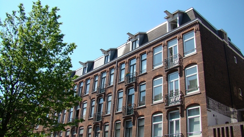
. These neighborhoods are characterised by ''revolutiebouw'' (literally: 'revolution architecture'): quickly and cheaply constructed 19th-century apartment blocks for worker's and middle-class families once considered of substandard quality, but currently in high demand for their charming, urban outlook. Neighbouring areas constructed in the early twentieth century such as Frederik Hendrikbuurt
Frederik Hendrikbuurt is a neighbourhood in the West district of Amsterdam, Netherlands and is situated between the canals Singelgracht and ''Kostverlorenvaart''. The neighbourhood, known locally by the moniker the "Fred", is centred on the Fred ...
, which borders the Frederik Hendrikplantsoen
Frederik Hendrikplantsoen is a park in Amsterdam West, on the edge of the Jordaan in one of the greenest historic neighbourhoods of Amsterdam. The park is located in the Frederik Hendrikbuurt
Frederik Hendrikbuurt is a neighbourhood in the W ...
park tend to be less densely populated and are characterised by the Amsterdam School
The Amsterdam School (Dutch: ''Amsterdamse School'') is a style of architecture that arose from 1910 through about 1930 in the Netherlands. The Amsterdam School movement is part of international Expressionist architecture, sometimes linked ...
of architecture contemporary with Art Nouveau
Art Nouveau (; ) is an international style of art, architecture, and applied art, especially the decorative arts. The style is known by different names in different languages: in German, in Italian, in Catalan, and also known as the Modern ...
and designed to create a total architectural experience, interior and exterior. Between 1990 and 2010, these neighborhoods formed the boroughs
A borough is an administrative division in various English-speaking countries. In principle, the term ''borough'' designates a self-governing walled town, although in practice, official use of the term varies widely.
History
In the Middle Ag ...
of Westerpark and Oud-West.
Between 1920 and 1940, further urban expansion projects known as ''Plan West'' were carried out in western direction on the territory of the former municipality of Sloten. The neighborhoods around Mercatorplein and Surinameplein squares became known as De Baarsjes
De Baarsjes () is a district ( nl, wijk) in Amsterdam-West situated west of the city center of Amsterdam, Netherlands. Named after a former hamlet, urban development started in the 1920s. It contains the neighbourhoods Admiralenbuurt, Chassébuur ...
, which has many examples of Amsterdam School
The Amsterdam School (Dutch: ''Amsterdamse School'') is a style of architecture that arose from 1910 through about 1930 in the Netherlands. The Amsterdam School movement is part of international Expressionist architecture, sometimes linked ...
architecture. From 1990 until 2010, these neighborhoods formed the borough
A borough is an administrative division in various English-speaking countries. In principle, the term ''borough'' designates a self-governing walled town, although in practice, official use of the term varies widely.
History
In the Middle Ag ...
of De Baarsjes
De Baarsjes () is a district ( nl, wijk) in Amsterdam-West situated west of the city center of Amsterdam, Netherlands. Named after a former hamlet, urban development started in the 1920s. It contains the neighbourhoods Admiralenbuurt, Chassébuur ...
. The neighborhood around Hoofddorpplein square became Hoofddorppleinbuurt. In 1990, Hoofddorppleinbuurt was added to the borough
A borough is an administrative division in various English-speaking countries. In principle, the term ''borough'' designates a self-governing walled town, although in practice, official use of the term varies widely.
History
In the Middle Ag ...
of Amsterdam-Zuid
Amsterdam-Zuid (; ''Amsterdam South'') is a borough (''stadsdeel'') of Amsterdam, Netherlands. The borough was formed in 2010 as a merger of the former boroughs Oud-Zuid and Zuideramstel. The borough has almost 138,000 inhabitants (2013). With 8, ...
.
North of these ''Plan West'' neighborhoods, the Bos en Lommer
Bos en Lommer (; English: Wood and Shade) is a neighborhood of Amsterdam, Netherlands. From 1990 to 2010 it was considered a district of the municipality of Amsterdam in the province of North Holland. As of May 1, 2010, it was merged into the new A ...
neighborhood was constructed the 1930s and 1940s. In 2007, this neighborhood was marked ''aandachtswijk'' (disadvantaged neighborhood) by minister for housing Ella Vogelaar
Catharina Pieternella "Ella" Vogelaar (23 December 1949 – 7 October 2019) was a Dutch politician of the Labour Party (PvdA) and trade union leader.
Political career
After graduating from the HBS in Zierikzee she attended the social academy ...
which made national urban renewal funds and programmes available to the area. The city of Amsterdam subsequently decided to apply the same status to De Baarsjes
De Baarsjes () is a district ( nl, wijk) in Amsterdam-West situated west of the city center of Amsterdam, Netherlands. Named after a former hamlet, urban development started in the 1920s. It contains the neighbourhoods Admiralenbuurt, Chassébuur ...
.
Borough government
 Until 2014, the Amsterdam boroughs, called ''stadsdelen'' or districts, were governed by a directly elected district council (''deelraad'') as well as a separate district executive board, the members of which were appointed and controlled by the council. Since the 2014 municipal elections, the district councils have been abolished and replaced by smaller, but still directly elected district committees (''bestuurscommissies''). The district committees are elected every four years, on the same day as the city's central
 municipal council
A municipal council is the legislative body of a municipality or local government area. Depending on the location and classification of the municipality it may be known as a city council, town council, town board, community council, rural counci ...
. Each district committee elects three of its members to form an executive committee (''dagelijks bestuur''). The district committees' jurisdiction is determined by the central municipal council
A municipal council is the legislative body of a municipality or local government area. Depending on the location and classification of the municipality it may be known as a city council, town council, town board, community council, rural counci ...
. Responsibilities delegated to the 2014-2018 district committees include parks and recreation, streets and squares, refuse collection, permits and events, preparation of zoning plans, passports and drivers licenses, and welfare work.
The district committee of Amsterdam-West consists of 15 members. The committee was elected on March 19, 2014. Six political parties are represented on the committee. In April 2014, the committee elected its executive committee. Executive committee Chair is Gerolf Bouwmeester ( D66), the other members are Fenna Ulichki ( GL) and Jeroen van Berkel ( PvdA).
The borough offices (''stadsdeelkantoor'' or district office) of Amsterdam-West are located at Bos en Lommerplein 250 and Baarsjesweg 224.
Neighborhoods

Frederik Hendrikbuurt
Frederik Hendrikbuurt is a neighbourhood in the West district of Amsterdam, Netherlands and is situated between the canals Singelgracht and ''Kostverlorenvaart''. The neighbourhood, known locally by the moniker the "Fred", is centred on the Fred ...
* Houthaven
Houthaven is a neighbourhood of Amsterdam, Netherlands situated in the West borough. Literally meaning "lumber port", Houthaven is a port situated along the IJ in Amsterdam's western port. It is bordered by a dam in the IJ river to the north and t ...
* Spaarndammerbuurt
Spaarndammerbuurt is a neighborhood of Amsterdam, Netherlands
)
, anthem = ( en, "William of Nassau")
, image_map =
, map_caption =
, subdivision_type = Sovereign state
, subdivision_name = Kingdom of the Netherlands
, established_ti ...
* Staatsliedenbuurt
* Waterwijk
* Zeeheldenbuurt
The Zeeheldenbuurt is a neighbourhood of Amsterdam, Netherlands. Located in the borough Amsterdam-West, it borders directly on the Westelijke Eilanden to the west. It lies between the Westerkanaal and the Westerdok; to the north is Houthaven
Hout ...
* Westerpark
In Oud-West:
* Kinkerbuurt
Kinkerbuurt () is the neighborhood in Amsterdam, Netherlands. Along with the Overtoombuurt, it is part of the neighborhood of Oud-West in the borough of Amsterdam-West. It was built at the beginning of the twentieth century when Amsterdam was bei ...
* Overtoombuurt
Overtoombuurt is a neighborhood of Amsterdam, Netherlands. Along with the Kinkerbuurt, it is part of the larger neighborhood of Oud-West in the borough of Amsterdam-West. The borough administration distinguishes several smaller areas within the O ...
In De Baarsjes
De Baarsjes () is a district ( nl, wijk) in Amsterdam-West situated west of the city center of Amsterdam, Netherlands. Named after a former hamlet, urban development started in the 1920s. It contains the neighbourhoods Admiralenbuurt, Chassébuur ...
:
* Admiralenbuurt
* Chassébuurt
* Postjesbuurt
* Trompbuurt
In the former borough of Bos en Lommer
Bos en Lommer (; English: Wood and Shade) is a neighborhood of Amsterdam, Netherlands. From 1990 to 2010 it was considered a district of the municipality of Amsterdam in the province of North Holland. As of May 1, 2010, it was merged into the new A ...
:
* Bos en Lommer
Bos en Lommer (; English: Wood and Shade) is a neighborhood of Amsterdam, Netherlands. From 1990 to 2010 it was considered a district of the municipality of Amsterdam in the province of North Holland. As of May 1, 2010, it was merged into the new A ...
* Kolenkitbuurt
* Landlust
* Sloterdijk (village)
References
External links
Borough of Amsterdam-West
{{Neighborhoods of Amsterdam
West
West or Occident is one of the four cardinal directions or points of the compass. It is the opposite direction from east and is the direction in which the Sunset, Sun sets on the Earth.
Etymology
The word "west" is a Germanic languages, German ...