|
Ambergate Railway Station
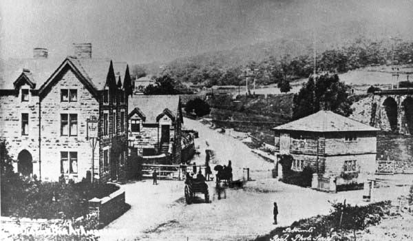
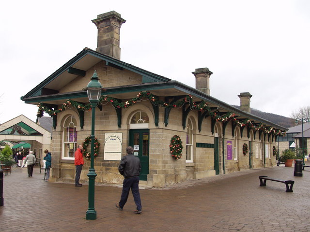
Ambergate railway station is a railway station owned by Network Rail and managed by East Midlands Railway. It serves the village of Ambergate in Derbyshire, England. The station is located on the Derwent Valley Line from Derby to Matlock, which diverges from the Midland Main Line just south of the station at Ambergate Junction. History It has a complicated history. The original station was built for the North Midland Railway in 1840, between Derby and Leeds. It was an ornate building, by Francis Thompson, which would have graced a Lord of the Manor. From Belper the line ran along the Derwent Valley, along a stretch called Broadholme, with four bridges across the river, through Longlands Tunnel, across the River Derwent and Derby road with a magnificent five-arch viaduct. It then entered Hag Wood Tunnel as turned towards the Amber Valley. The station building was just north of this tunnel. Shortly afterwards a proposal was made for an Ambergate, Nottingham, Boston and E ... [...More Info...] [...Related Items...] OR: [Wikipedia] [Google] [Baidu] |
Ambergate
Ambergate is a village in Derbyshire, England, situated where the River Amber joins the River Derwent, and where the A610 road from Ripley and Nottingham joins the A6 that runs along the Derwent valley between Derby to the south and Matlock to the north. Sawmills and Ridgeway are neighbouring hamlets, and Alderwasley, Heage, Nether Heage and Crich are other significant neighbouring settlements. The village forms part of the Heage and Ambergate ward of Ripley Town Council with a population of 5,013 at the 2011 Census. Ambergate is within the Derwent Valley Mills UNESCO World Heritage site, and has historical connections with George Stephenson; Ambergate is notable for its railway heritage and telephone exchange. Ambergate has an active community life, particularly centred on the school, pubs, churches, sports clubs; and annual village carnival which is relatively large and consistent locally, with popular associated events in carnival week and throughout the year. The car ... [...More Info...] [...Related Items...] OR: [Wikipedia] [Google] [Baidu] |
Belper
Belper is a town and civil parishes in England, civil parish in the Non-metropolitan district, local government district of Amber Valley in Derbyshire, England, located about north of Derby on the River Derwent, Derbyshire, River Derwent. As well as Belper itself, the parish also includes the village of Milford, Derbyshire, Milford and the hamlets of Bargate, Derbyshire, Bargate, Blackbrook and Makeney. As of the United Kingdom Census 2011, 2011 Census, the parish had a population of 21,823. Originally a centre for the nail-making industry since Medieval times, Belper expanded during the early Industrial Revolution to become one of the first mill towns with the establishment of several textile mills; as such, it forms part of the Derwent Valley Mills World Heritage Site. History At the time of the Normans, Norman occupation, Belper was part of the land centred on Duffield, Derbyshire, Duffield held by the family of Henry de Ferrers. The Domesday Book of 1086 records a manor of ... [...More Info...] [...Related Items...] OR: [Wikipedia] [Google] [Baidu] |
Manchester, Buxton, Matlock And Midlands Junction Railway
The Manchester, Buxton, Matlock and Midland Junction Railway ran from a junction with the Midland Railway at Ambergate to Rowsley north of Matlock, Derbyshire, Matlock and thence to Buxton. In time it would become part of the Midland Railway's main line between London and Manchester, but it was initially planned as a route from Manchester to the East of England, via the proposed Ambergate, Nottingham, Boston and Eastern Junction Railway which would meet it a little further north along the North Midland line at Ambergate. The Act for a line from just south of Stockport to Ambergate was passed in 1846. Currently, the section north of Millers Dale is open as the Great Rocks Line, Great Rocks freight line, Derby to Matlock still holds passenger services as the Derwent Valley line, Matlock to Rowsley is the Peak Rail heritage line, and Rowsley to Buxton has become the Monsal Trail for cycling, horse riding and walking. Ambergate to Rowsley The initial plan was for "An Act for mak ... [...More Info...] [...Related Items...] OR: [Wikipedia] [Google] [Baidu] |
Rowsley
Rowsley () is a village on the A6 road in the English county of Derbyshire. The population as at the 2011 census was 507. It is at the point where the River Wye flows into the River Derwent and prospered from mills on both. The border of the Peak District National Park runs through the village west of the River Wye and immediately to the north of Chatsworth Road. The Peak District Boundary Walk goes through the village. Overview Notable features are the bridge over the River Derwent, St Katherine's Church, Rowsley and the Grade-II*-listed Peacock hotel, originally built in 1652 as a manor house by John Stevenson, agent to Lady Manners, whose family crest bearing a peacock gives it its name. Both Longfellow and Landseer are said to have stayed there. Nearby is Chatsworth House, home of the Duke and Duchess of Devonshire. It was the site of an extensive motive power depot and marshalling yard, the first being built by the Manchester, Buxton, Matlock and Midlands Junction ... [...More Info...] [...Related Items...] OR: [Wikipedia] [Google] [Baidu] |
Stretton Railway Station
Stretton railway station was a railway station at Stretton, Derbyshire, England built by the North Midland Railway. History Stretton station was first opened in 1841 as Smithy Moor, a year after the line opened, but renamed later in 1841. It is also called "Shelton" in the Railway Guide. It was situated at the Derbyshire summit and the highest point of the line, after the stations at Ambergate and Wingfield, and just before the Clay Cross Tunnel. The first station buildings were of wooden construction, but these were later replaced by brick built station and station master's house. Shortly after this was completed, the station master's house was incorporated into the station building, and a new station master's house was provided. Although this proved adequate at the time by the 1880s, there were petitions to the Midland Railway for better facilities. In May 1888 the Midland Railway requested tenders for the reconstruction of the station buildings at Stretton. The contract w ... [...More Info...] [...Related Items...] OR: [Wikipedia] [Google] [Baidu] |
Wingfield Railway Station
Wingfield railway station served a rural area of Derbyshire, England between 1840 and 1967. History It was built in 1836-40 by the North Midland Railway (NMR) on its line between Derby and Leeds, close to the road between South Wingfield and Oakerthorpe. The station closed in 1967 and the buildings, by Francis Thompson, still stand, but had become derelict until restoration work, funded by a National Lottery grant, began in 2019, with completion expected by 2023. The line adjacent to the station is still in use as part of the Midland Main Line. Thompson designed 13 stations on the NMR, of which Wingfield is the only one to survive as-built. Current status The empty station building and paved forecourt are Grade II* listed due to being one of the earliest surviving railway station buildings, and the only surviving example from the opening of the line. However, it has been listed on Historic England's Heritage at Risk Register for some years as being in a 'very bad' state. In M ... [...More Info...] [...Related Items...] OR: [Wikipedia] [Google] [Baidu] |
Bullbridge Aqueduct
The Bull Bridge Aqueduct was situated on the Cromford Canal, built in 1794, at Bullbridge east of Ambergate along the Amber Valley, where it turned sharply to cross the valley and the Ambergate to Nottingham road. The Cromford canal is in Derbyshire, England. Known officially as the "Amber Aqueduct", it was actually an earthwork bank surmounted by masonry walls across the valley some thirty feet high in places. It was pierced by three arches. One was for the river. The second was an accommodation arch for the houses behind, which are now the small village known as Bullbridge. The main road passed through the third which was the original Bull Bridge. In 1840, George Stephenson engineered the North Midland Railway to intersect the canal at this point on its way from Ambergate to Wingfield and Stretton, towards Clay Cross and Chesterfield. The lines were laid in the space between the river and the road, but were carried on an embankment over the side road leading to Bullbridge ... [...More Info...] [...Related Items...] OR: [Wikipedia] [Google] [Baidu] |
Cromford Canal
The Cromford Canal ran from Cromford to the Erewash Canal in Derbyshire, England with a branch to Pinxton. Built by William Jessop with the assistance of Benjamin Outram, its alignment included four tunnels and 14 locks. From Cromford it ran south following the contour line along the east side of the valley of the Derwent to Ambergate, where it turned eastwards along the Amber valley. It turned sharply to cross the valley, crossing the river and the Ambergate to Nottingham road, by means of an aqueduct at Bullbridge, before turning towards Ripley. From there the Butterley Tunnel took it through to the Erewash Valley. From the tunnel it continued to Ironville, the junction for the branch to Pinxton, and then descended through fourteen locks to meet the Erewash Canal at Langley Mill. The Pinxton Branch became important as a route for Nottinghamshire coal, via the Erewash, to the River Trent and Leicester and was a terminus of the Mansfield and Pinxton Railway. A long sect ... [...More Info...] [...Related Items...] OR: [Wikipedia] [Google] [Baidu] |
Chesterfield, Derbyshire
Chesterfield is a market town and unparished area in the Borough of Chesterfield, Derbyshire, England, north of Derby and south of Sheffield at the confluence of the River Rother and River Hipper. In 2011 the built-up-area subdivision had a population of 88,483, making it the second-largest settlement in Derbyshire, after Derby. The wider borough had a population of 103,801 in 2011. In 2011, the town had a population of 76,753. It has been traced to a transitory Roman fort of the 1st century CE. The name of the later Anglo-Saxon village comes from the Old English ''ceaster'' (Roman fort) and ''feld'' (pasture). It has a sizeable street market three days a week. The town sits on an old coalfield, but little visual evidence of mining remains. The main landmark is the crooked spire of the Church of St Mary and All Saints. History Chesterfield was in the Hundred of Scarsdale. The town received its market charter in 1204 from King John, which constituted the town as a f ... [...More Info...] [...Related Items...] OR: [Wikipedia] [Google] [Baidu] |
Grantham
Grantham () is a market and industrial town in the South Kesteven district of Lincolnshire, England, situated on the banks of the River Witham and bounded to the west by the A1 road. It lies some 23 miles (37 km) south of the Lincoln and 22 miles (35 km) east of Nottingham. The population in 2016 was put at 44,580. The town is the largest settlement and the administrative centre of South Kesteven District. Grantham was the birthplace of the UK Prime Minister Margaret Thatcher. Isaac Newton was educated at the King's School. The town was the workplace of the UK's first warranted female police officer, Edith Smith in 1914. The UK's first running diesel engine was made there in 1892 and the first tractor in 1896. Thomas Paine worked there as an excise officer in the 1760s. The villages of Manthorpe, Great Gonerby, Barrowby, Londonthorpe and Harlaxton form outlying suburbs of the town. Etymology Grantham's name is first attested in the Domesday Book (1086); ... [...More Info...] [...Related Items...] OR: [Wikipedia] [Google] [Baidu] |
Colwick
Colwick ( ) is a village, civil parish, and suburb of the city of Nottingham, in the English ceremonial county of Nottinghamshire. It is situated to the east of Nottingham's city boundary, and forms the Colwick ward within the local government district of Gedling. At the time of the 2011 census, the village had a population of 2,829. History The village is recorded in the Domesday Book of 1086, since when the De-Colwick, Musters and Byron families have all owned the village. The etymology of the place-name is from Old English ''wic'' "specialised industrial farm" with an uncertain first element, possibly ''col'' "coal", although there have never been coal mines in the area. In 1844 there was a gruesome murder at 'Saville's Spinney', then part of Colwick Park and later part of Colwick Woods. William Saville murdered his wife and three children in the woods on Tuesday 21 May. Their bodies were found one day later by John Swinscoe of Carlton who fetched the parish constable ... [...More Info...] [...Related Items...] OR: [Wikipedia] [Google] [Baidu] |
Ambergate, Nottingham, Boston And Eastern Junction Railway
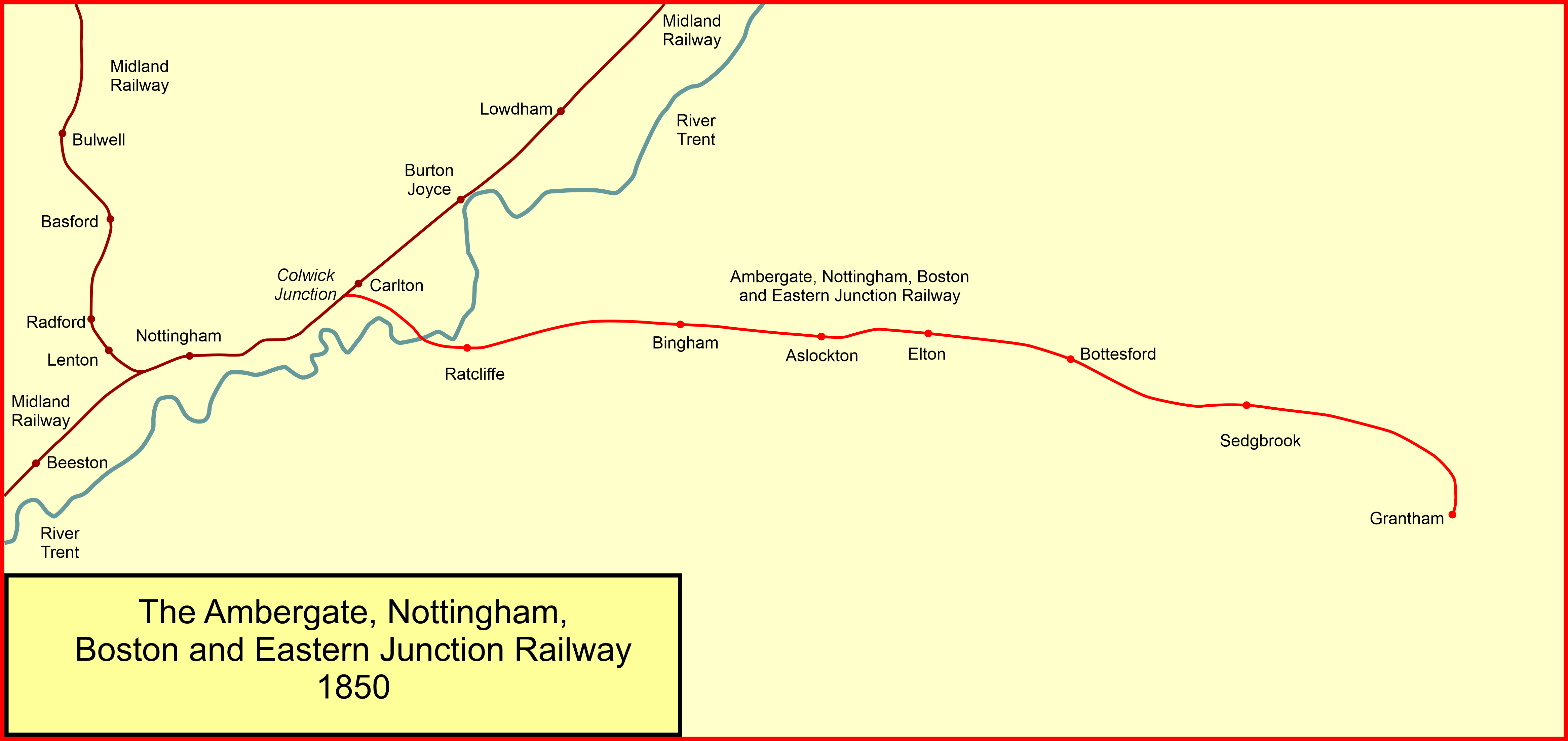
The Ambergate, Nottingham and Boston and Eastern Junction Railway was a British railway company, which hoped to connect Lancashire with the port of Boston, in Lincolnshire. It was authorised in 1846 but was unable to raise much money. It opened a standard gauge line from a junction near Nottingham to Grantham in 1853. At Nottingham it was to rely on the Midland Railway, but that company was hostile and obstructive. The Ambergate company was leased to the Great Northern Railway in 1855, and they built their own Nottingham station, opened in 1857. In 1860 the company changed its name to the Nottingham and Grantham Railway and Canal Company. In 1875 the Great Northern Railway opened a line into Derbyshire and the former Nottingham to Grantham line became an important trunk route, particularly for goods and mineral traffic. The original line from Colwick to Grantham is still in use as the Nottingham–Grantham line. The freight traffic has greatly diminished, but the line is used ... [...More Info...] [...Related Items...] OR: [Wikipedia] [Google] [Baidu] |


.jpg)
