|
Amagerbro
Amagerbro is an area in the northern part of the island Amager and a district in Copenhagen. The area is known as a working class area, and has approximately 20,000 inhabitants. The district has two metro stations, Amagerbro station and Lergravsparken station. Amagerbrogade, a main shopping street, runs through it. The district is bordered by the Amager Fælled nature reserve, the Christianhavn Ramparts and Kløvermarken, the industrial area near Amager Boulevard and Øresundsvej. The main shopping and business area is Amagerbrogade and its sidestreets. Establishments in Amagerbro include Kofoeds School offering assistance to people with social problems, the Sundholm Activity Centre accommodating the homeless for short periods, and The Royal School of Library and Information Science The Royal School of Library and Information Science (abbr. RSLIS, da, Det Informationsvidenskabelige Akademi) is a school under the University of Copenhagen that provides higher education in the ... [...More Info...] [...Related Items...] OR: [Wikipedia] [Google] [Baidu] |
Amagerbrogade
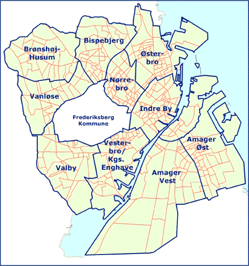
Amagerbrogade is the main shopping street and thoroughfare of the part of Copenhagen, Denmark that is located on the island of Amager . It begins at the end of the causeway which connects Amager to Christianshavn and the city centre on the other side of the harbour, and runs south until it reaches the municipal border with Tårnby where it continues as Amager Landevej. The street marks the border between Amager Vest and Amager Øst, two of the ten official districts of Copenhagen. Amagerbrogade arose when the country road leading in and out of Copenhagen's Amager Gate was urbanized towards the end of the 18th century after the city's old fortifications had been decommissioned and the no-built zone outside them released. It is one of four such ''-bro streets''. History Om the 18th century the road network outside Amager Gate was generally limited and in a poor state. From 1780 to 1790 the main road to Store Magleby and Dragør was upgraded but only a short stretch was cobbled. ... [...More Info...] [...Related Items...] OR: [Wikipedia] [Google] [Baidu] |
Copenhagen
Copenhagen ( or .; da, København ) is the capital and most populous city of Denmark, with a proper population of around 815.000 in the last quarter of 2022; and some 1.370,000 in the urban area; and the wider Copenhagen metropolitan area has 2,057,142 people. Copenhagen is on the islands of Zealand and Amager, separated from Malmö, Sweden, by the Øresund strait. The Øresund Bridge connects the two cities by rail and road. Originally a Viking fishing village established in the 10th century in the vicinity of what is now Gammel Strand, Copenhagen became the capital of Denmark in the early 15th century. Beginning in the 17th century, it consolidated its position as a regional centre of power with its institutions, defences, and armed forces. During the Renaissance the city served as the de facto capital of the Kalmar Union, being the seat of monarchy, governing the majority of the present day Nordic region in a personal union with Sweden and Norway ruled by the Danis ... [...More Info...] [...Related Items...] OR: [Wikipedia] [Google] [Baidu] |
Geography Of Copenhagen
Copenhagen ( or .; da, København ) is the capital and most populous city of Denmark, with a proper population of around 815.000 in the last quarter of 2022; and some 1.370,000 in the urban area; and the wider Copenhagen metropolitan area has 2,057,142 people. Copenhagen is on the islands of Zealand and Amager, separated from Malmö, Sweden, by the Øresund strait. The Øresund Bridge connects the two cities by rail and road. Originally a Viking fishing village established in the 10th century in the vicinity of what is now Gammel Strand, Copenhagen became the capital of Denmark in the early 15th century. Beginning in the 17th century, it consolidated its position as a regional centre of power with its institutions, defences, and armed forces. During the Renaissance the city served as the de facto capital of the Kalmar Union, being the seat of monarchy, governing the majority of the present day Nordic region in a personal union with Sweden and Norway ruled by the Danish ... [...More Info...] [...Related Items...] OR: [Wikipedia] [Google] [Baidu] |
Amager
Amager ( or, especially among older speakers, ) in the Øresund is Denmark's most densely populated island, with more than 212,000 inhabitants (January 2021) a small appendage to Zealand. The protected natural area of ''Naturpark Amager'' (including Kalvebod Fælled) makes up more than one-third of the island's total area of 96 km2. The Danish capital, Copenhagen Municipality, is partly situated on Amager, covering the northern part of the island, which is connected to the much larger island of Zealand by eight bridges and a metro tunnel. Amager also has a connection across the Øresund to Sweden, the Øresund Bridge. Its western part begins with a tunnel from Amager to another Danish island, Peberholm. Copenhagen Airport is located on the island, around from Copenhagen city centre. Amager is the largest island in the Øresund, and the only one with a large population. , 212,661 people lived on the island, including its northern tip, Christianshavn. The northern part is in ... [...More Info...] [...Related Items...] OR: [Wikipedia] [Google] [Baidu] |
Lergravsparken Station
Lergravsparken station is a deep-level Copenhagen Metro station in the East Amager district of Copenhagen, Denmark. It is located on Øresundsvej in a corner of the public park Lergravsparken from which it takes its name. It opened in 2002. History Servicing the M2 line, it was the eastern terminus until the extension of the line to Copenhagen Airport Copenhagen Airport, Kastrup ( da, Københavns Lufthavn, Kastrup, ; ) is an international airport serving Copenhagen, Denmark, Zealand, the Øresund Region, and southern Sweden including Scania. It is the second largest airport in the Nordic ... was finished in late 2007. It is located in fare zone 1. Design The station has bicycle parking facilities. External linksLergravsparken station on www.m.dkLergravsparken station on www.m.dk M2 (Copenhagen Metro) stations Railway stations opened in 2002 2002 establishments in Denmark {{Copenhagen-metro-stub ... [...More Info...] [...Related Items...] OR: [Wikipedia] [Google] [Baidu] |
Metro Station
A metro station or subway station is a station for a rapid transit system, which as a whole is usually called a "metro" or "subway". A station provides a means for passengers to purchase Train ticket, tickets, board trains, and Emergency evacuation, evacuate the system in the case of an emergency. In the United Kingdom, they are known as underground stations, most commonly used in reference to the London Underground. Location The location of a metro station is carefully planned to provide easy access to important urban facilities such as roads, commercial centres, major buildings and other Transport hub, transport nodes. Most stations are located underground, with entrances/exits leading up to ground or street level. The bulk of the station is typically positioned under land reserved for public thoroughfares or Urban park, parks. Placing the station underground reduces the outside area occupied by the station, allowing vehicles and pedestrians to continue using the ground-le ... [...More Info...] [...Related Items...] OR: [Wikipedia] [Google] [Baidu] |
Amager Fælled
Amager Common (Danish: ''Amager Fælled'') is a 223 hectare nature reserve on Amager in Copenhagen Copenhagen ( or .; da, København ) is the capital and most populous city of Denmark, with a proper population of around 815.000 in the last quarter of 2022; and some 1.370,000 in the urban area; and the wider Copenhagen metropolitan ar .... It contains meadows, lakes, forests and a range of wildlife such as Highland cattle. History The area where Amager Common now lies is a former military area. Abandoned in 1964, Amager Common gained protected status in two rounds: ''Kalvebodkilefredningen'' in 1990 and ''Amager Fælled fredningen'' in 1994. Amager Common contained one of Copenhagen's execution sites, with the final execution taking place on April 22, 1845. References Parks in Copenhagen Parks and open spaces in Copenhagen {{CapitalDK-stub ... [...More Info...] [...Related Items...] OR: [Wikipedia] [Google] [Baidu] |
Kløvermarken
Kløvermarken (the Clover Field) is a large green space in the Amager Øst, Amager East district of Copenhagen, Denmark. Originally a military area, it has later been home to both Copenhagen's first air field and a camp for German refugees after World War II. It now features football pitches and other sports facilities as well as a nature centre for children. Kløvermarken is bounded by Uplandsgade, Raffinaderivej and Kløvermarksvej. The area between the park and Stadsgraven, the canal which separates Amager from Christianshavn, is dominated by allotments. History Early history Kløvermarken is the last undeveloped section of Christianshavns Fælled, which used to serve as a military training area. The name Kløvermarken is first seen in 1847. At that time the area reached all the way to the Øresund coast where the Stricker Battery had been constructed in 1801 as the most southernly point on Fortifications of Copenhagen, Copenhagen's fortifications. It was expanded in 1875&ndas ... [...More Info...] [...Related Items...] OR: [Wikipedia] [Google] [Baidu] |
Kofoeds School
Kofoeds School ( da, Kofoeds Skole) in Copenhagen, Denmark, is an organization carrying out social work for adults according to the "social pedagogical" principle of personal and vocational empowerment. The school, founded in 1928, bases its work on Christian and humanitarian principles and among other things, the Danish folk high school movement. It offers education, workshop activities, counseling, accommodation, emergency assistance and relief measures. The aim of the school is to assist people with social problems in improving their social life and relieve them from their underprivileged social situation. The efforts are holistic and the targets tuned to people’s own abilities and qualifications. The school concept Kofoeds School is based on the concept that if people are to be assisted socially, they have to be helped educationally, but the terms education and school are understood in the widest sense, not associated exclusively with narrow vocational qualifications. The con ... [...More Info...] [...Related Items...] OR: [Wikipedia] [Google] [Baidu] |
The Royal School Of Library And Information Science
The Royal School of Library and Information Science (abbr. RSLIS, da, Det Informationsvidenskabelige Akademi) is a school under the University of Copenhagen that provides higher education in the field of library and information science. It has now merged with another department to Department of Communication. It is based in Copenhagen, Denmark. It is a member of iSchools, a consortium directed to understanding the role of information in nature and human culture. There has also been a location in Aalborg, however this campus was shut down in the summer of 2017. History The school was an independent institution from 1956 to 2013. It was founded in 1956 and replaced the Danish State Library School that had been established in 1918. In 1973, RSLIS set up a library school branch in Aalborg. Up to 1969 RSLIS offered a sandwich course leading solely to the qualification of public librarian. Those graduating with the Diploma in public librarianship would take up positions as librarians i ... [...More Info...] [...Related Items...] OR: [Wikipedia] [Google] [Baidu] |

.png)


