|
3rd Maryland Regiment
The 3rd Maryland Regiment was an infantry regiment of the Continental Army during the American Revolutionary War. It served from 1776 to 1783, mostly in the Middle Atlantic Region of the conflict. Background The 3rd Maryland Regiment was organized on 27 March 1776 of eight companies from Anne Arundel, Prince George's, Talbot, Harford and Somerset counties of the colony of Maryland. The regiment was authorized on 16 September 1776 for service with the Continental Army and was assigned on 27 December 1776 to the main element. 1st Maryland Brigade On 22 May 1777 it was assigned to the 1st Maryland Brigade. The regiment was re-organized to nine companies on 12 May 1779. On 5 April 1780 the 1st Maryland Brigade was reassigned to the Southern Department. The regiment was relieved from the 1st Maryland Brigade on 1 January 1781. It was assigned to Gist's Brigade on 24 September 1781 in the main Continental Army. Three days later (27 September 1781) Gist's Brigade was reassi ... [...More Info...] [...Related Items...] OR: [Wikipedia] [Google] [Baidu] |
Continental Congress
The Continental Congress was a series of legislative bodies, with some executive function, for thirteen of Britain's colonies in North America, and the newly declared United States just before, during, and after the American Revolutionary War. The term "Continental Congress" most specifically refers to the First and Second Congresses of 1774–1781 and, at the time, was also used to refer to the Congress of the Confederation of 1781–1789, which operated as the first national government of the United States until being replaced under the Constitution of the United States. Thus, the term covers the three congressional bodies of the Thirteen Colonies and the new United States that met between 1774 and 1789. The First Continental Congress was called in 1774 in response to growing tensions between the colonies culminating in the passage of the Intolerable Acts by the British Parliament. It met for about six weeks and sought to repair the fraying relationship between Britain and t ... [...More Info...] [...Related Items...] OR: [Wikipedia] [Google] [Baidu] |
Battle Of Hobkirk's Hill
The Battle of Hobkirk's Hill (sometimes referred to as the Second Battle of Camden) was a battle of the American Revolutionary War fought on April 25, 1781, near Camden, South Carolina. A small American force under Nathanael Greene occupying Hobkirk's Hill, north of Camden, was attacked by British troops led by Francis Rawdon. After a fierce clash, Greene retreated, leaving Rawdon's smaller force in possession of the hill. Despite the victory, Rawdon soon fell back to Camden and two weeks later found it necessary to abandon Camden and withdraw toward Charleston, South Carolina. The battle was one of four contests in which Greene was defeated, though his overall strategy was successful in depriving the British of all South Carolina except Charleston. The battlefield marker is located at Broad Street and Greene Street two miles north of the center of modern Camden.Greene p. 228-233 Background After the Battle of Guilford Court House, Cornwallis's force was spent and in great need of ... [...More Info...] [...Related Items...] OR: [Wikipedia] [Google] [Baidu] |
George Washington
George Washington (February 22, 1732, 1799) was an American military officer, statesman, and Founding Father who served as the first president of the United States from 1789 to 1797. Appointed by the Continental Congress as commander of the Continental Army, Washington led the Patriot forces to victory in the American Revolutionary War and served as the president of the Constitutional Convention of 1787, which created the Constitution of the United States and the American federal government. Washington has been called the " Father of his Country" for his manifold leadership in the formative days of the country. Washington's first public office was serving as the official surveyor of Culpeper County, Virginia, from 1749 to 1750. Subsequently, he received his first military training (as well as a command with the Virginia Regiment) during the French and Indian War. He was later elected to the Virginia House of Burgesses and was named a delegate to the Continental Congress ... [...More Info...] [...Related Items...] OR: [Wikipedia] [Google] [Baidu] |
Charleston, South Carolina
Charleston is the largest city in the U.S. state of South Carolina, the county seat of Charleston County, and the principal city in the Charleston–North Charleston metropolitan area. The city lies just south of the geographical midpoint of South Carolina's coastline on Charleston Harbor, an inlet of the Atlantic Ocean formed by the confluence of the Ashley, Cooper, and Wando rivers. Charleston had a population of 150,277 at the 2020 census. The 2020 population of the Charleston metropolitan area, comprising Berkeley, Charleston, and Dorchester counties, was 799,636 residents, the third-largest in the state and the 74th-largest metropolitan statistical area in the United States. Charleston was founded in 1670 as Charles Town, honoring King CharlesII, at Albemarle Point on the west bank of the Ashley River (now Charles Towne Landing) but relocated in 1680 to its present site, which became the fifth-largest city in North America within ten years. It remained unincorpor ... [...More Info...] [...Related Items...] OR: [Wikipedia] [Google] [Baidu] |
Maryland
Maryland ( ) is a state in the Mid-Atlantic region of the United States. It shares borders with Virginia, West Virginia, and the District of Columbia to its south and west; Pennsylvania to its north; and Delaware and the Atlantic Ocean to its east. Baltimore is the largest city in the state, and the capital is Annapolis. Among its occasional nicknames are '' Old Line State'', the ''Free State'', and the '' Chesapeake Bay State''. It is named after Henrietta Maria, the French-born queen of England, Scotland, and Ireland, who was known then in England as Mary. Before its coastline was explored by Europeans in the 16th century, Maryland was inhabited by several groups of Native Americans – mostly by Algonquian peoples and, to a lesser degree, Iroquoian and Siouan. As one of the original Thirteen Colonies of England, Maryland was founded by George Calvert, 1st Baron Baltimore, a Catholic convert"George Calvert and Cecilius Calvert, Barons Baltimore" William Hand Browne, ... [...More Info...] [...Related Items...] OR: [Wikipedia] [Google] [Baidu] |
Somerset County, Maryland
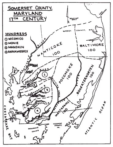
Somerset County is the southernmost county in the U.S. state of Maryland. As of the 2020 census, the population was 24,620, making it the second-least populous county in Maryland. The county seat is Princess Anne. The county was named for Mary, Lady Somerset, the wife of Sir John Somerset and daughter of Thomas Arundell, 1st Baron Arundell of Wardour (c. 1560–1639). She was also the sister of Anne Calvert, Baroness Baltimore (1615–1649), who later lent her name to Anne Arundel County, which was erected in 1650 as the Province of Maryland's third county. Somerset County is located on the state's Eastern Shore. It is included in the Salisbury, MD- DE Metropolitan Statistical Area. The University of Maryland Eastern Shore is located in Princess Anne. History Initial settlements Somerset County was settled and established by English colonists in part due to a response to the Province/Dominion of Virginia passing a law in 1659/1660 requiring Quakers in the colony to convert ... [...More Info...] [...Related Items...] OR: [Wikipedia] [Google] [Baidu] |
Harford County, Maryland
Harford County is located in the U.S. state of Maryland. As of the 2020 census, the population was 260,924. Its county seat is Bel Air. Harford County is included in the Baltimore-Columbia-Towson, MD Metropolitan Statistical Area, which is also included in the Washington-Baltimore-Arlington, DC-MD-VA-WV-PA Combined Statistical Area. History In 1608 the area was settled by Massawomecks and Susquehannocks. The first European to see the area was John Smith in 1608 when he traveled up the Chesapeake Bay from Jamestown. In 1652, the English and Susquehannocks signed a treaty at what is now Annapolis for the area now called Harford County. Harford County was formed on March 22, 1774 from the eastern part of Baltimore County with a population of 13,000 people. On March 22, 1775, Harford County hosted the signers of the Bush Declaration, a precursor document to the American Revolution. On January 22, 1782, Bel Air became the county seat. Havre de Grace, a city incorporated i ... [...More Info...] [...Related Items...] OR: [Wikipedia] [Google] [Baidu] |
Talbot County, Maryland
Talbot County is located in the heart of the Eastern Shore of Maryland in the U.S. state of Maryland. As of the 2020 United States Census, 2020 census, the population was 37,526. Its county seat is Easton, Maryland, Easton. The county was named for Lady Grace Talbot, the wife of Robert Talbot (statesman), Sir Robert Talbot, an Anglo-Ireland, Irish statesman, and the sister of Cecilius Calvert, 2nd Baron Baltimore, Lord Baltimore. Talbot County comprises the Easton, MD Micropolitan Statistical Area, which is also included in the Washington, D.C., Washington–Baltimore–Arlington County, Virginia, Arlington, DC–MD–Virginia, VA–West Virginia, WV–Pennsylvania, PA Baltimore–Washington metropolitan area, Combined Statistical Area. Talbot County is bordered by Queen Anne's County, Maryland, Queen Anne's County to the north, Caroline County, Maryland, Caroline County to the east, Dorchester County, Maryland, Dorchester County to the south, and the Chesapeake Bay to the west. ... [...More Info...] [...Related Items...] OR: [Wikipedia] [Google] [Baidu] |
Prince George's County, Maryland
) , demonym = Prince Georgian , ZIP codes = 20607–20774 , area codes = 240, 301 , founded date = April 23 , founded year = 1696 , named for = Prince George of Denmark , leader_title = Executive , leader_name = Angela D. Alsobrooks ( D) , seat wl = Upper Marlboro , largest city wl = Bowie , area_total_sq_mi = 499 , area_land_sq_mi = 483 , area_water_sq_mi = 16 , area percentage = 3.2 , census yr = 2020 , pop = 967201 , pop_est_as_of = 2021 , population_est = , density_sq_mi = 1900 , district = 4th , district2 = 5th , time zone = Eastern , web = www.princegeorgescountymd.gov Prince George's County (often shortened to PG County) is a county located in the U.S. state of Maryland bordering the eastern portion of Washington, D.C. As of the 2020 U.S. census, the population was 967,201, making it the second-most populous county in Maryland, behind Montgomery County. The 2020 census counted an increase of nearly 104,000 in the previous ten years. Its c ... [...More Info...] [...Related Items...] OR: [Wikipedia] [Google] [Baidu] |
Anne Arundel County, Maryland
Anne Arundel County (; ), also notated as AA or A.A. County, is located in the U.S. state of Maryland. As of the 2020 United States census, its population was 588,261, an increase of just under 10% since 2010. Its county seat is Annapolis, which is also the capital of the state. The county is named for Lady Anne Arundell (c. 1615/1616–1649), a member of the ancient family of Arundells in Cornwall, England, and the wife of Cecilius Calvert, 2nd Baron Baltimore (1605–1675), founder and first lord proprietor of the colony Province of Maryland. Anne Arundel County is included in the Baltimore–Columbia–Towson metropolitan statistical area, which is also included in the Washington–Baltimore–Arlington combined statistical area. History The county was named for Lady Anne Arundell, (1615/1616–1649), the daughter of Thomas Arundell, 1st Baron Arundell of Wardour, members of the ancient family of Arundells in Cornwall, England. She married Cecilius Calvert, second Lord ... [...More Info...] [...Related Items...] OR: [Wikipedia] [Google] [Baidu] |
Map Of Maryland Counties PG AA Talbot Somerset Harford
A map is a symbolic depiction emphasizing relationships between elements of some space, such as objects, regions, or themes. Many maps are static, fixed to paper or some other durable medium, while others are dynamic or interactive. Although most commonly used to depict geography, maps may represent any space, real or fictional, without regard to context or scale, such as in brain mapping, DNA mapping, or computer network topology mapping. The space being mapped may be two dimensional, such as the surface of the earth, three dimensional, such as the interior of the earth, or even more abstract spaces of any dimension, such as arise in modeling phenomena having many independent variables. Although the earliest maps known are of the heavens, geographic maps of territory have a very long tradition and exist from ancient times. The word "map" comes from the , wherein ''mappa'' meant 'napkin' or 'cloth' and ''mundi'' 'the world'. Thus, "map" became a shortened term referring to ... [...More Info...] [...Related Items...] OR: [Wikipedia] [Google] [Baidu] |
American Revolutionary War
The American Revolutionary War (April 19, 1775 – September 3, 1783), also known as the Revolutionary War or American War of Independence, was a major war of the American Revolution. Widely considered as the war that secured the independence of the United States, fighting began on April 19, 1775, followed by the Lee Resolution on July 2, 1776, and the Declaration of Independence on July 4, 1776. The American Patriots were supported by the Kingdom of France and, to a lesser extent, the Dutch Republic and the Spanish Empire, in a conflict taking place in North America, the Caribbean, and the Atlantic Ocean. Established by royal charter in the 17th and 18th centuries, the American colonies were largely autonomous in domestic affairs and commercially prosperous, trading with Britain and its Caribbean colonies, as well as other European powers via their Caribbean entrepôts. After British victory over the French in the Seven Years' War in 1763, tensions between the motherland and he ... [...More Info...] [...Related Items...] OR: [Wikipedia] [Google] [Baidu] |


