|
Warren County, Iowa
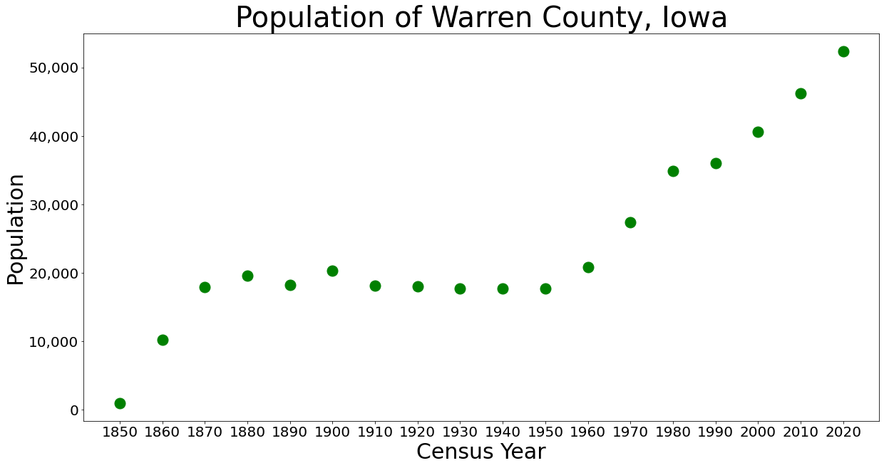
Warren County is a County (United States), county located in the U.S. state of Iowa. As of the 2020 United States census, 2020 census, the population was 52,403. The county seat is Indianola, Iowa, Indianola. Warren County is included in the Des Moines, Iowa, Des Moines–West Des Moines, Iowa, West Des Moines, IA Des Moines metropolitan area, Metropolitan Statistical Area. History Warren County was formed in 1846. It was named after General Joseph Warren, a hero in the American Revolutionary War. The present Warren County Courthouse (Iowa), Warren County Court House was opened in 1939. Geography According to the U.S. Census Bureau, the county has a total area of , of which is land and (0.6%) is water. Major highways * Interstate 35 in Iowa, Interstate 35 * U.S. Route 65 in Iowa, U.S. Highway 65 * U.S. Route 69 in Iowa, U.S. Highway 69 * Iowa Highway 5 * Iowa Highway 28 * Iowa Highway 92 * Iowa Highway 316 Adjacent counties *Polk County, Iowa, Polk County (north) *M ... [...More Info...] [...Related Items...] OR: [Wikipedia] [Google] [Baidu] |
Joseph Warren
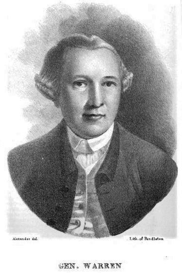
Joseph Warren (June 11, 1741 – June 17, 1775), a Founding Father of the United States, was an American physician who was one of the most important figures in the Patriot (American Revolution), Patriot movement in Boston, Massachusetts, Boston during the early days of the American Revolution, eventually serving as President of the revolutionary Massachusetts Provincial Congress. Warren enlisted Paul Revere and William Dawes on April 18, 1775, to leave Boston and spread the alarm that the British garrison in Boston was setting out to raid the town of Concord, Massachusetts, Concord and arrest rebel leaders John Hancock and Samuel Adams. Warren had been commissioned a major general in the colony's militia shortly before the June 17, 1775 Battle of Bunker Hill. Rather than exercise his rank, Warren chose to participate in the battle as a private (military), private soldier, and was killed in combat when British troops stormed the redoubt atop Breed's Hill. His death, immortali ... [...More Info...] [...Related Items...] OR: [Wikipedia] [Google] [Baidu] |
Elongated Circle 28
Elongation may refer to: * Elongation (astronomy) * Elongation (geometry) * Elongation (plasma physics) * Part of transcription of DNA into RNA of all types, including mRNA, tRNA, rRNA, etc. * Part of translation (biology) of mRNA into proteins * Elongated organisms * Elongation (mechanics) In physics and continuum mechanics, deformation is the change in the shape or size of an object. It has dimension of length with SI unit of metre (m). It is quantified as the residual displacement of particles in a non- rigid body, from an con ..., linear deformation See also * {{disambiguation ... [...More Info...] [...Related Items...] OR: [Wikipedia] [Google] [Baidu] |
White (U
White is the lightest color and is achromatic (having no chroma). It is the color of objects such as snow, chalk, and milk, and is the opposite of black. White objects fully (or almost fully) reflect and scatter all the visible wavelengths of light. White on television and computer screens is created by a mixture of red, blue, and green light. The color white can be given with white pigments, especially titanium dioxide. In ancient Egypt and ancient Rome, priestesses wore white as a symbol of purity, and Romans wore white togas as symbols of citizenship. In the Middle Ages and Renaissance a white unicorn symbolized chastity, and a white lamb sacrifice and purity. It was the royal color of the kings of France as well as the flag of monarchist France from 1815 to 1830, and of the monarchist movement that opposed the Bolsheviks during the Russian Civil War (1917–1922). Greek temples and Roman temples were faced with white marble, and beginning in the 18th c ... [...More Info...] [...Related Items...] OR: [Wikipedia] [Google] [Baidu] |
Madison County, Iowa
Madison County is a county located in the U.S. state of Iowa. As of the 2020 census, the population was 16,548. The county seat is Winterset. Madison County is included in the Des Moines– West Des Moines, IA Metropolitan Statistical Area. Madison County is famous for being the county where John Wayne was born, and for a number of covered bridges. These bridges were featured in Robert James Waller's 1992 novella ''The Bridges of Madison County'', as well as the 1995 film and 2014 musical based on it. History Madison County was formed on January 13, 1846. It has been self-governed since 1849. It was named after James Madison (1751–1836), the fourth President of the United States (between 1809 and 1817). Hiram Hurst was the first European-American settler in Madison County, having come from Missouri about April 15, 1846. Geography According to the U.S. Census Bureau, the county has a total area of , of which is land and (0.2%) is water. Major highways * Intersta ... [...More Info...] [...Related Items...] OR: [Wikipedia] [Google] [Baidu] |
Clarke County, Iowa
Clarke County is a county located in the U.S. state of Iowa. As of the 2020 census, the population was 9,748. The county seat is Osceola. The county was formed in January 1846, one of twelve counties established by legislative action in a comprehensive act. It was named for James Clarke, a Governor of the Iowa Territory. History The first courthouse for Clarke County was a wood frame two–story structure in Osceola. In 1883 it was replaced with a brick structure on former park area in the town square. By the 1950s this building was insufficient, and the present modern structure was completed in 1956. It was added to the National Register of Historic Places in 2018. Geography According to the US Census Bureau, the county has a total area of , of which is land and (0.1%) is water. Adjacent counties *Decatur County (south) * Lucas County (east) * Madison County (northwest) * Union County (west) * Warren County (northeast) Highways * Interstate 35 – runs north–sout ... [...More Info...] [...Related Items...] OR: [Wikipedia] [Google] [Baidu] |
Lucas County, Iowa
Lucas County is a County (United States), county located in the U.S. state of Iowa. As of the 2020 United States census, 2020 census, the population was 8,634. The county seat is Chariton, Iowa, Chariton. The county was formed in 1846 and was named for Robert Lucas (governor), Robert Lucas, a Governor of the Territory. Geography According to the U.S. Census Bureau, the county has a total area of , of which is land and (0.9%) is water. Major highways * U.S. Route 34 in Iowa, U.S. Highway 34 * U.S. Route 65 in Iowa, U.S. Highway 65 * Iowa Highway 14 Adjacent counties *Warren County, Iowa, Warren County (northwest) *Marion County, Iowa, Marion County (northeast) *Monroe County, Iowa, Monroe County (east) *Wayne County, Iowa, Wayne County (south) *Clarke County, Iowa, Clarke County (west) Demographics 2020 census The 2020 census recorded a population of 8,634 in the county, with a population density of . 96.75% of the population reported being of one race. 92.76% were ... [...More Info...] [...Related Items...] OR: [Wikipedia] [Google] [Baidu] |
Marion County, Iowa
Marion County is a county in the U.S. state of Iowa. As of the 2020 census, the population was 33,414. The county seat is Knoxville. It is named for Francis Marion, a brigadier general from South Carolina in the American Revolutionary War. Geography According to the U.S. Census Bureau, the county has a total area of , of which is land and (2.8%) is water. Major highways * Iowa Highway 5 * Iowa Highway 14 * Iowa Highway 92 * Iowa Highway 163 * Iowa Highway 316 Adjacent counties * Jasper County (north) * Mahaska County (east) * Monroe County (southeast) * Lucas County (southwest) * Warren County (west) Demographics 2020 census The 2020 census recorded a population of 33,414 in the county, with a population density of . 96.24% of the population reported being of one race. 91.15% were non-Hispanic White, 0.87% were Black, 2.09% were Hispanic, 0.21% were Native American, 1.20% were Asian, 0.06% were Native Hawaiian or Pacific Islander and 4.41% were some other race or ... [...More Info...] [...Related Items...] OR: [Wikipedia] [Google] [Baidu] |
Polk County, Iowa
Polk County is located in the U.S. state of Iowa. As of the 2020 United States census, 2020 census, the population was 492,401. making it the List of counties in Iowa, most populous county in Iowa, and was estimated to be 505,255 in 2023. It is home to over 15% of the state's residents. The county seat is Des Moines, Iowa, Des Moines, which is also the capital city of Iowa. Polk County is included in the Des Moines–West Des Moines, Iowa, West Des Moines, IA Des Moines metropolitan area, Metropolitan Statistical Area. History On January 13, 1846, the legislative body of the Iowa Territory authorized the creation of twelve counties in the Territory, with general descriptions of their boundaries. On January 17 they further enacted a resolution setting the effective date of the county government for Jasper and Polk Counties as March 1, 1846. Polk County's name referred to United States President James K. Polk, who served from 1845 to 1849. The first courthouse, a two-story struct ... [...More Info...] [...Related Items...] OR: [Wikipedia] [Google] [Baidu] |
Iowa Highway 316
Iowa Highway 316 (Iowa 316) is a spur route in central Iowa. The route begins at Iowa Highway 5 south of Swan, Iowa, Swan and ends at the eastern city limits of Runnells, Iowa, Runnells. Prior to 2003, Iowa 316 extended north to Iowa Highway 163 north of Runnells, but that portion was turned over to Polk County, Iowa, Polk County. The highway's primary purpose is a crossing of the Des Moines River south of Runnells, Iowa, Runnells. Route description Iowa 316 begins at an intersection with Iowa Highway 5 south of Swan, Iowa, Swan. The first are in Warren County, while the next of the road form the Warren County, Iowa, Warren/Marion County, Iowa, Marion county border. it crosses over a BNSF Railway line and turns into Warren County. For the rest of its length, the highway closely parallels these railroad tracks. Iowa 316 in Warren County is bordered to the south and east by the Middle River (Iowa), Middle River and to the north and east by the Des Moi ... [...More Info...] [...Related Items...] OR: [Wikipedia] [Google] [Baidu] |
Elongated Circle 316
Elongation may refer to: * Elongation (astronomy) * Elongation (geometry) * Elongation (plasma physics) * Part of transcription of DNA into RNA of all types, including mRNA, tRNA, rRNA, etc. * Part of translation (biology) of mRNA into proteins * Elongated organisms * Elongation (mechanics) In physics and continuum mechanics, deformation is the change in the shape or size of an object. It has dimension of length with SI unit of metre (m). It is quantified as the residual displacement of particles in a non- rigid body, from an con ..., linear deformation See also * {{disambiguation ... [...More Info...] [...Related Items...] OR: [Wikipedia] [Google] [Baidu] |


