|
Tauber
The Tauber () is a river in Franconia (Baden-Württemberg and Bavaria), Germany. It is a left tributary of the Main and is in length. The name derives from the Celtic word for water (compare: Dover). Course It flows through Rothenburg ob der Tauber, Creglingen, Weikersheim, Bad Mergentheim, Königshofen, Tauberbischofsheim, and flows into the river Main in Wertheim am Main. The Tauber Valley Cycleway is a bicycle path which runs about 101 km along the course of the river. There is a medieval bridge over the river near Rothenburg ob der Tauber. See also *List of rivers of Baden-Württemberg *List of rivers of Bavaria A list of rivers of Bavaria, Germany: A * Aalbach * Abens * Ach * Afferbach * Affinger Bach * Ailsbach * Aisch * Aiterach * Alpbach *Alster * Altmühl * Alz * Amper * Anlauter * Arbach * Arbachgraben * Aschaff * Aschbach * Attel * Aubach, tributa ... References Rivers of Baden-Württemberg Rivers of Bavaria Ansbach (district) Würzburg ... [...More Info...] [...Related Items...] OR: [Wikipedia] [Google] [Baidu] |
Tauberbischofsheim
Tauberbischofsheim () is a German town in the north-east of Baden-Württemberg on the river Tauber with a population of about 13,200. It is the capital of the Main-Tauber (district), Main-Tauber district. It is a popular tourist destination due to its numerous historical buildings, including substantial remains of the medieval town fortifications. Tauberbischofsheim is also known for its fencing#Competitive fencing, fencers, who have won several Olympic Games, Olympic medals and world championships. Geography Location Tauberbischofsheim is located in the ''Tauberfranken'' region of Franconia on the river Tauber. Constituent communities Tauberbischofsheim consists of the main town of Tauberbischofsheim, as well as the ''Ortsteil, Stadtteile'' Dienstadt, Distelhausen, Dittigheim, Dittwar, Hochhausen and Impfingen.Stadt Tauberbischofsheim''Die Stadtteile der Kreisstadt Tauberbischofsheim''. www.tauberbischofsheim.de. Accessed 19 October 2014. The boundaries of these ''Stadtteile'' ... [...More Info...] [...Related Items...] OR: [Wikipedia] [Google] [Baidu] |
Tauber Valley Cycleway
The Tauber Valley Cycleway (), official name in German: ''Liebliches Taubertal (der Klassiker)'', in English ''Lovely Tauber Valley (the Classic)'', also ''Charming Tauber Valley (the Classic)'', is a German bicycle path running about 101 km along the River Tauber in Franconia, Germany. The cycleway runs from Rothenburg ob der Tauber via Bad Mergentheim and Tauberbischofsheim to Wertheim at the confluence of the Tauber and the Main. The path runs along its whole length through the valley of the Tauber and has only gentle ascents. At both ends and along the route there are railway stations.Touristikgemeinschaft Liebliches Taubertal''Radfahren – Der Klassiker''www.liebliches-taubertal.de, 23. May 2015. The General German Bicycle Club (ADFC) rated the trail five stars in 2009, the second path in Germany to receive this award after Main Cycleway.Touristikgemeinschaft Liebliches Taubertal''Fünf Sterne für den "Klassiker"''In: Tauber-Zeitung. www.swp.de. 31 October 2009. ... [...More Info...] [...Related Items...] OR: [Wikipedia] [Google] [Baidu] |
Rothenburg Ob Der Tauber
Rothenburg ob der Tauber () is a town located in the district of Ansbach (district), Ansbach of Mittelfranken (Middle Franconia), the Franconia region of Bavaria, Germany. It is well known for its well-preserved Middle Ages, medieval old town, a destination for tourists from around the world. It is part of the popular Romantic Road through southern Germany. Today it is one of only four towns in Germany that still have completely intact city walls, the other three being Nördlingen, Dinkelsbühl and Berching, all in Bavaria. Rothenburg was a free imperial city (German: Reichsstadt) from the late Middle Ages to 1803. In 1884 Johann Friedrich (von) Hessing (1838–1918) built ''Wildbad Rothenburg o.d.T.'' 1884–1903. Name The name "Rothenburg ob der Tauber" is German language, German for "Red castle above the Tauber", describing the town's location on a plateau overlooking the Tauber River. Rothenburg Castle, in close vicinity to the village and also called ''Alte Burg'' (old cas ... [...More Info...] [...Related Items...] OR: [Wikipedia] [Google] [Baidu] |
Tauber Basin
The Tauber () is a river in Franconia (Baden-Württemberg and Bavaria), Germany. It is a left tributary of the Main and is in length. The name derives from the Celtic word for water (compare: Dover). Course It flows through Rothenburg ob der Tauber, Creglingen, Weikersheim, Bad Mergentheim, Königshofen, Tauberbischofsheim, and flows into the river Main in Wertheim am Main. The Tauber Valley Cycleway is a bicycle path which runs about 101 km along the course of the river. There is a medieval bridge over the river near Rothenburg ob der Tauber. See also *List of rivers of Baden-Württemberg *List of rivers of Bavaria A list of rivers of Bavaria, Germany: A * Aalbach * Abens * Ach * Afferbach * Affinger Bach * Ailsbach * Aisch * Aiterach * Alpbach *Alster * Altmühl * Alz * Amper * Anlauter * Arbach * Arbachgraben * Aschaff * Aschbach * Attel * Aubach, tributa ... References Rivers of Baden-Württemberg Rivers of Bavaria Ansbach (district) Würzburg ... [...More Info...] [...Related Items...] OR: [Wikipedia] [Google] [Baidu] |
Tauber Bridge, Rothenburg Ob Der Tauber
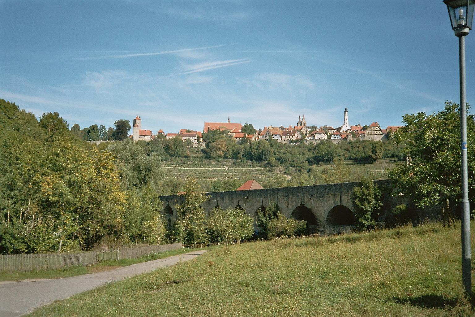
The Tauber Bridge at Rothenburg ob der Tauber is an historic road bridge that spans the Tauber Valley west of the town centre of the Middle Franconian town of Rothenburg ob der Tauber in Bavaria. The structure carries a local link road to Leuzenbronn and the Tauber Valley Way and has a 4.0 metre wide roadway and a 1.0 metre wide footpath. History The double bridge with its two rows of arches, one on top of the other, was probably built around 1330. It lies at the foot of the southwestern valley side below Rothenburg ob der Tauber and was part of a trade route from Augsburg to Würzburg. In terms of building activity, it is known that it was renovated in 1791, after the four upper arches had collapsed the year before. In 1925, the eastern approach to the bridge was widened and, twenty years later. In 1945, the structure was blown up by German troops. Rebuilding commenced in 1955, and took a good year. The rebuilt bridge was opened on 10 November 1956. See also * ... [...More Info...] [...Related Items...] OR: [Wikipedia] [Google] [Baidu] |
Franconia
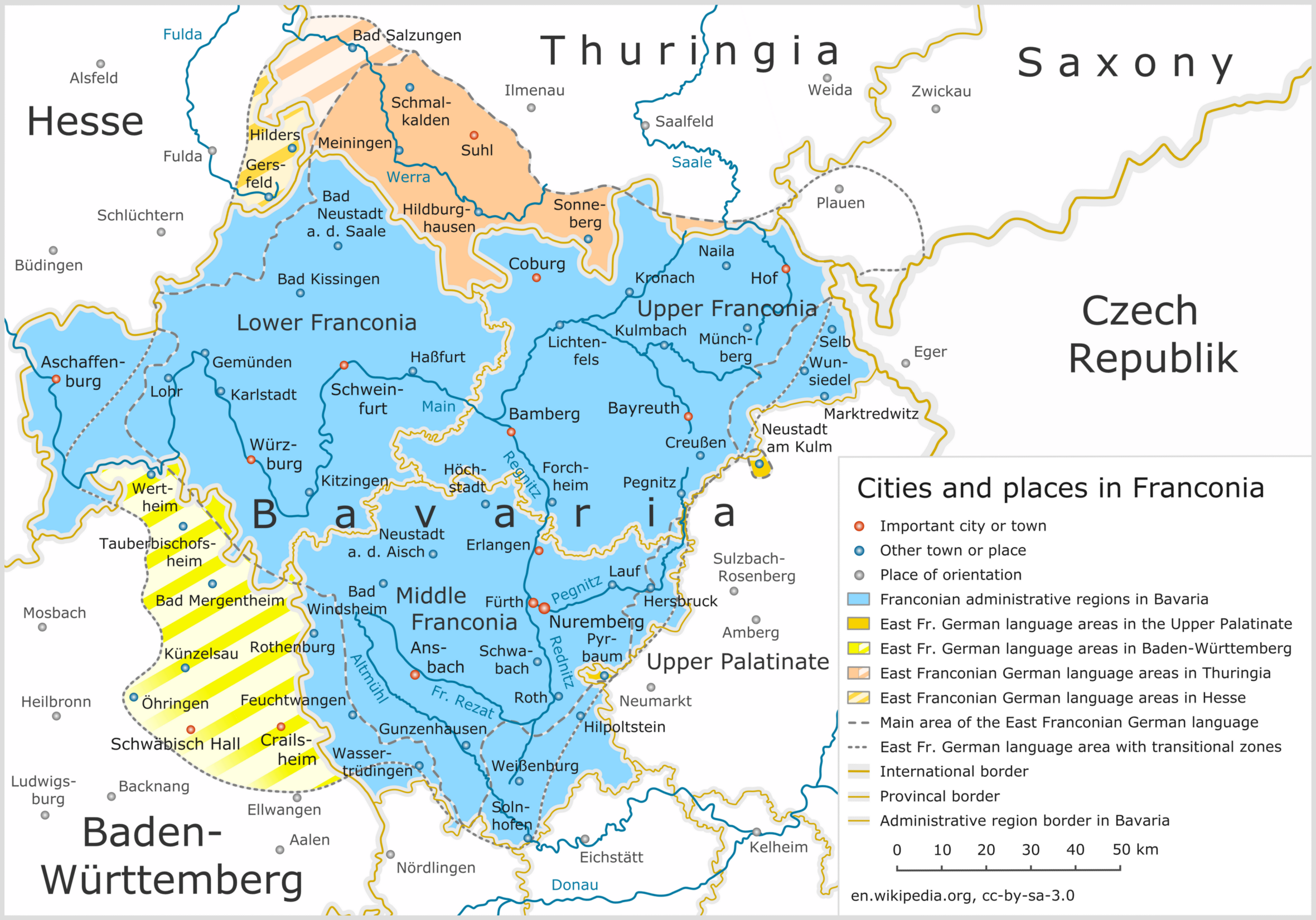
Franconia ( ; ; ) is a geographical region of Germany, characterised by its culture and East Franconian dialect (). Franconia is made up of the three (governmental districts) of Lower Franconia, Lower, Middle Franconia, Middle and Upper Franconia in Bavaria, the adjacent, East Franconian, Franconian-speaking South Thuringia, south of the Thuringian Forest—which constitutes the language boundary between Franconian and Thuringian—and the eastern parts of Heilbronn-Franconia in Baden-Württemberg. Those parts of the Vogtland lying in Saxony (largest city: Plauen) are sometimes regarded as Franconian as well, because the Vogtlandian dialects are mostly East Franconian. The inhabitants of Saxon Vogtland, however, mostly do not consider themselves Franconian. On the other hand, the inhabitants of the Hessian dialect, Hessian-speaking parts of Lower Franconia west of the Spessart (largest city: Aschaffenburg) do consider themselves Franconian, although not speaking the dialect. He ... [...More Info...] [...Related Items...] OR: [Wikipedia] [Google] [Baidu] |
Weikersheim
Weikersheim is a town in the Main-Tauber district of Baden-Württemberg, Germany. History Town rights were granted to Weikersheim in 1313. As one of the seats of the House of Hohenlohe, until 1756 Weikersheim's town center was dominated by Weikersheim Castle, residence of the Hohenlohe-Weikersheim line. During the process of German mediatization from 1806 to 1809, Weikersheim was awarded to the Kingdom of Württemberg, whose government assigned the city to . In 1938, the Oberamt was reorganized as , under whose jurisdiction Weikersheim remained. From 1 January 1972 to 1 January 1975, Weikersheim incorporated eight municipalities. In that time, , and as a result Weikersheim was assigned to the newly created Main-Tauber district. In 2000, the old town and palace were placed under protection as cultural monuments. Geography The township ('' Stadt'') of Weikersheim covers of the Main-Tauber district of Baden-Württemberg, a state of the Federal Republic of Germany. Weikersheim ... [...More Info...] [...Related Items...] OR: [Wikipedia] [Google] [Baidu] |
Wertheim Am Main
Wertheim (; East Franconian German, East Franconian: ''Wärde'') is a town in southwestern Germany, in the state of Baden-Württemberg with a population of around 23,400. It is located on the confluence of the rivers Tauber and Main (river), Main. Wertheim is best known for its landmark castle and medieval town centre. Geography Wertheim is the most northerly town in the state of Baden-Württemberg. It is situated at the confluence of the rivers Tauber and Main, on the Main's left bank. It borders on the Odenwald hills and the Spessart range to the north across the river Main. Wertheim is located in the Main-Tauber district. Neighboring communities The following towns and communities border on Wertheim, listed clockwise starting in the east: Holzkirchen, Upper Bavaria, Holzkirchen, Helmstadt and Neubrunn, Lower Franconia, Neubrunn (all Würzburg (district), district Würzburg, Bavaria), Werbach and Külsheim (both Main-Tauber district), Neunkirchen, Lower Franconia, Neunkirche ... [...More Info...] [...Related Items...] OR: [Wikipedia] [Google] [Baidu] |
List Of Rivers Of Baden-Württemberg
A list of rivers of Baden-Württemberg, Germany: A *Aal (Kocher), Aal *Aalbach (Main), Aalbach *Aalenbach *Ablach (Danube), Ablach *Ach (Blau), Ach *Acher *Adelbach *Aich (river), Aich *Aid (Würm), Aid *Aischbach (Kinzig), Aischbach, tributary of the Kinzig *Aischbach (Körsch), Aischbach, tributary of the Körsch *Aitrach (Danube), Aitrach, tributary of the Danube *Aitrach (Iller), Aitrach, tributary of the Iller *Alb (Upper Rhine), Alb, tributary of the Rhine at Eggenstein-Leopoldshafen *Alb (High Rhine), Alb, tributary of the Rhine at Albbruck *Ammer (Neckar), Ammer *Amorsbach *Andelsbach *Annenbach *Arbach (Neckar), Arbach *Argen *Aschenbach (Mühlbach), Aschenbach *Aspenbach *Avenbach B *Badische Eschach *Bära *Bellamonter Rottum *Berneck (river), Berneck *Biber (Rhine), Biber *Biberbach (Danube), Biberbach *Bibers *Black Kocher *Black Lauter *Blau (Danube), Blau *Blinde Rot *Bollenbach (Argen), Bollenbach *Bottwar *Braunsel *Breg (river), Breg *Brehmbach *Breitenbach (Ech ... [...More Info...] [...Related Items...] OR: [Wikipedia] [Google] [Baidu] |
Lauda-Königshofen
Lauda-Königshofen () is a town in the Main-Tauber (district), Main-Tauber district in Baden-Württemberg, Germany. It is situated on the river Tauber, 7 km southeast of Tauberbischofsheim, and 30 km southwest of Würzburg. Most of the roughly 300 houses in the traditional village of Königshofen date to between the 16th century and mid-19th century, and it is known for the 500+ year-old Königshöfer Messe, an annual festival that attracts 150,000 people over the 10-day festival. Lauda station is at a junction of the Franconia Railway and the Tauber Valley Railway. Districts The 12 districts with population (as of 2001): Area in km2 (as in 2006) Twin towns * Boissy-Saint-Léger (France) * Paks (Hungary) * Rátka (Hungary) Sports * FV Lauda, soccer * Lauda Hornets, American football Notable natives * Johann Gottfried von Aschhausen, (1575–1622), Prince-Bishopric of Bamberg, Prince-Bishop of Bamberg and of Prince-Bishopric of Würzburg, Würzburg * Johann Rudolf Z ... [...More Info...] [...Related Items...] OR: [Wikipedia] [Google] [Baidu] |
Bad Mergentheim
Bad Mergentheim (; Mergentheim until 1926; East Franconian German, East Franconian: ''Märchedol'') is a town in the Main-Tauber-Kreis district in the German state of Baden-Württemberg. It has a population of around 23,000. An officially recognized spa town since 1926, Bad Mergentheim is also known as the headquarters of the Teutonic Order from 1526 until 1809. Geography Subdivisions Since administrative reform in the 1970s the following villages have been part of the municipality: Althausen ''(pop. 600)'', Apfelbach ''(350)'', Dainbach ''(370)'', Edelfingen ''(1,400''; birthplace of the American biochemist Julius Adler (biochemist), Julius Adler), Hachtel ''(360)'', Herbsthausen ''(200)'', Löffelstelzen ''(1,000)'', Markelsheim ''(2,000)'', Neunkirchen ''(1,000)'', Rengershausen ''(480)'', Rot ''(260)'', Stuppach ''(680)'', Wachbach ''(1,300)'' History Mergentheim is mentioned in chronicles as early as 1058, as the residence of the family of the counts of Hohenlohe. The brothe ... [...More Info...] [...Related Items...] OR: [Wikipedia] [Google] [Baidu] |


