|
London, Kiribati
London (Gilbertese: ''Ronton''; historically: ''Londres'') is a village in Kiribati, located on the island of Kiritimati, within the archipelago of Line Islands. It is the administrative capital of Kiritimati. Name London was originally named ''Londres'' by French priest Emmanuel Rougier, who was leasing the island from Britain from 1917 to 1939, and wanted to honor the island's British connection. In 1939, the island reverted to Britain and ''Londres'' was anglicised to London. Its local name, Ronton, is derived from "London" written in Gilbertese according to its phonology. Demographics In 2015, London was inhabited by 1,895 people, making it the second most populous of the four villages on the island. The overwhelming majority of the population of Kiritimati as of 2023 lived in the Tabwakea, Banana, London, or Poland villages. Infrastructure The headquarters of the Ministry of Line and Phoenix Islands Development is located in London. The Port of London is Kiritimati ... [...More Info...] [...Related Items...] OR: [Wikipedia] [Google] [Baidu] |
Kiribati
Kiribati, officially the Republic of Kiribati, is an island country in the Micronesia subregion of Oceania in the central Pacific Ocean. Its permanent population is over 119,000 as of the 2020 census, and more than half live on Tarawa. The state comprises list of islands of Kiribati, 32 atolls and one remote raised coral atoll, raised coral island, Banaba. Its total land area is dispersed over of ocean. The islands' spread straddles the equator and the 180th meridian. The International Date Line goes around Kiribati and swings far to the east, almost reaching 150th meridian west, 150°W. This brings Kiribati's easternmost islands, the southern Line Islands south of Hawaii, into the same day as the Gilbert Islands and places them in the most advanced time zone on Earth: UTC+14:00, UTC+14. Kiribati gained its independence from the United Kingdom, becoming a sovereign state in 1979. The capital, South Tarawa, now the most populated area, consists of a number of islets, connect ... [...More Info...] [...Related Items...] OR: [Wikipedia] [Google] [Baidu] |
Subdivisions Of Kiribati
In Kiribati, there are no longer official administrative divisions but it is possible to divide Kiribati geographically into one isolated island and three archipelagos or island groups: * Banaba – isolated island * Gilbert Islands * Line Islands * Phoenix Islands Kiribati was divided into six districts before gaining independence: * Banaba * Tarawa * Northern Gilbert Islands * Central Gilbert Island * Southern Gilbert Islands * Line Islands Four of the former districts (including Tarawa) lie in the Gilbert Islands, where 90% of the country's population lives. Only three of the Line Islands are inhabited, while the Phoenix Islands are uninhabited apart from Canton Island (20 people) and had no official representation. Banaba itself is sparsely inhabited now (330 people in 2020). There is also a representative non-elected of the Banabans relocated since 1945 to Rabi Island in the country of Fiji. Local councils There are 21 inhabited islands in Kiribati. Each inhabited i ... [...More Info...] [...Related Items...] OR: [Wikipedia] [Google] [Baidu] |
Kiritimati
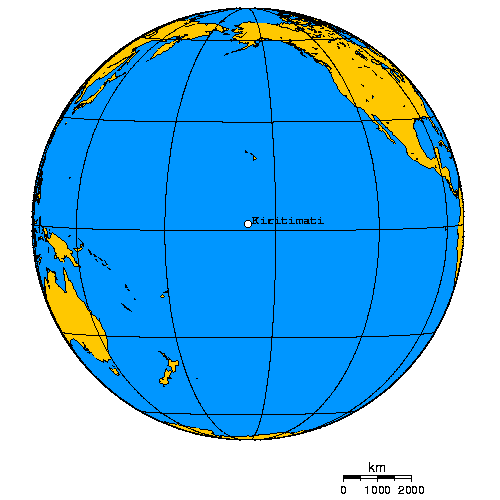
Kiritimati (), also known as Christmas Island, is a Pacific Ocean atoll in the northern Line Islands. It is part of the Republic of Kiribati. The name is derived from the English word "Christmas" written in Gilbertese according to its phonology, in which the combination is pronounced /s/. Kiritimati is one of the world's largest atolls in terms of land area, consisting of about land area and a network of lagoons;. The atoll is about in perimeter, while the lagoon shoreline extends for over . Kiritimati comprises over 70% of the total land area of Kiribati, a country encompassing 33 Pacific atolls and islands. It lies north of the equator, south of Honolulu, and from San Francisco. Kiritimati is in the world's furthest forward time zone, UTC+14, and is therefore one of the first inhabited places on Earth to experience New Year's Day (see also Caroline Atoll, Kiribati). Although it lies east of the 180th meridian, the Republic of Kiribati realigned the International ... [...More Info...] [...Related Items...] OR: [Wikipedia] [Google] [Baidu] |
Gilbertese Language
Gilbertese (), also known as Kiribati (sometimes ''Kiribatese'' or ''Tungaru''), is an Austronesian language spoken mainly in Kiribati. It belongs to the Micronesian branch of the Oceanic languages. The word ''Kiribati'', the current name of the islands, is the local adaptation of the European name "Gilberts" to Gilbertese phonology. Early European visitors, including Commodore John Byron, whose ships happened on Nikunau in 1765, had named some of the islands the Kingsmill or Kings Mill Islands or for the Northern group ''les îles Mulgrave'' in French but in 1820 they were renamed, in French, ''les îles Gilbert'' by Admiral Adam Johann von Krusenstern, after Captain Thomas Gilbert, who, along with Captain John Marshall, had passed through some of these islands in 1788. Frequenting of the islands by Europeans, Americans and Chinese dates from whaling and oil trading from the 1820s, when no doubt Europeans learnt to speak it, as Gilbertese learnt to speak English and other ... [...More Info...] [...Related Items...] OR: [Wikipedia] [Google] [Baidu] |
Line Islands
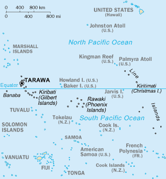
The Line Islands, Teraina Islands or Equatorial Islands () are a chain of 11 atolls (with partly or fully enclosed lagoons, except Vostok and Jarvis) and coral islands (with a surrounding reef) in the central Pacific Ocean, south of the Hawaiian Islands. Eight of the atolls are parts of Kiribati. The remaining three— Jarvis Island, Kingman Reef, and Palmyra Atoll—are territories of the United States grouped with the United States Minor Outlying Islands. The Line Islands, all of which were formed by volcanic activity, are one of the longest island chains in the world, stretching from northwest to southeast. One of them, Starbuck Island, is near the geographic center of the Pacific Ocean (). Another, Kiritimati, has the largest land area of any atoll in the world. Only Kiritimati, Tabuaeran, and Teraina have a permanent population. Besides the 11 confirmed atolls and islands, Filippo Reef is shown on some maps, but its existence is doubted. The International Date L ... [...More Info...] [...Related Items...] OR: [Wikipedia] [Google] [Baidu] |
United Kingdom
The United Kingdom of Great Britain and Northern Ireland, commonly known as the United Kingdom (UK) or Britain, is a country in Northwestern Europe, off the coast of European mainland, the continental mainland. It comprises England, Scotland, Wales and Northern Ireland. The UK includes the island of Great Britain, the north-eastern part of the island of Ireland, and most of List of islands of the United Kingdom, the smaller islands within the British Isles, covering . Northern Ireland shares Republic of Ireland–United Kingdom border, a land border with the Republic of Ireland; otherwise, the UK is surrounded by the Atlantic Ocean, the North Sea, the English Channel, the Celtic Sea and the Irish Sea. It maintains sovereignty over the British Overseas Territories, which are located across various oceans and seas globally. The UK had an estimated population of over 68.2 million people in 2023. The capital and largest city of both England and the UK is London. The cities o ... [...More Info...] [...Related Items...] OR: [Wikipedia] [Google] [Baidu] |
Phonology
Phonology (formerly also phonemics or phonematics: "phonemics ''n.'' [''obsolescent''] 1. Any procedure for identifying the phonemes of a language from a corpus of data. 2. (formerly also phonematics) A former synonym for phonology, often preferred by the American Structuralists and reflecting the importance in structuralist work of phonemics in sense 1.": "phonematics ''n.'' 1. [''obsolete''] An old synonym for phonemics (sense 2).") is the branch of linguistics that studies how languages systematically organize their phonemes or, for sign languages, their constituent parts of signs. The term can also refer specifically to the sound or sign system of a particular language variety. At one time, the study of phonology related only to the study of the systems of phonemes in spoken languages, but now it may relate to any Linguistic description, linguistic analysis either: Sign languages have a phonological system equivalent to the system of sounds in spoken languages. The buil ... [...More Info...] [...Related Items...] OR: [Wikipedia] [Google] [Baidu] |
Tabwakea
Tabwakea is the largest village on the island of Kiritimati, within the archipelago of Line Islands of Kiribati. Name Tabwakea means turtle in Gilbertese language, Gilbertese, which refers to the island's first name given by James Cook, Turtles Island, which later became Christmas Island (Kiritimati). Demographics In 2015, Tabwakea was inhabited by 3,001 people, making it the most populous village in the Line Islands The Line Islands, Teraina Islands or Equatorial Islands () are a chain of 11 atolls (with partly or fully enclosed lagoons, except Vostok and Jarvis) and coral islands (with a surrounding reef) in the central Pacific Ocean, south of the Hawa .... References Populated places in Kiribati Kiritimati {{Kiribati-geo-stub ... [...More Info...] [...Related Items...] OR: [Wikipedia] [Google] [Baidu] |
Banana, Kiribati
Banana is a village in Kiribati, located in the northeast of the island of Kiritimati, within the archipelago of Line Islands. It is located close to Cassidy International Airport. Name In 1962, when over 4,000 American servicemen were on the island as part of Operation Dominic Operation Dominic was a series of 31 nuclear test explosions ("shots") with a total yield conducted in 1962 by the United States in the Pacific. This test series was scheduled quickly, in order to respond in kind to the Soviet resumption of t ..., the village became known as Banana for unclear reasons. Demographics According to the 2015 census, Banana was inhabited by 1,209 people, making it the third most populous of the four villages on the island. This includes 567 children aged 0-17, 529 people aged 18-49, and 113 people over 50 years of age. Social media incident In 2024, a Twitter account (@KiribatiGov) which had successfully impersonated the Kiribati government for some time went ... [...More Info...] [...Related Items...] OR: [Wikipedia] [Google] [Baidu] |
Poland, Kiribati
Poland is a village in Kiribati, located on the westernmost part of the island of Kiritimati, within the archipelago of Line Islands. Name Poland was named in honor of Polish mechanic Stanisław Pełczyński, who greatly improved the island's coconut plantation by introducing a modified irrigation system that could effectively water palm trees during the dry season. Demographics In 2015, Poland was inhabited by 351 people. Infrastructure Poland has a kindergarten, a primary school, and a Catholic church. Climate In 2013, the Ministry of Environment in Warsaw, Poland produced a video featuring the village to highlight its sea level rise The sea level has been rising from the end of the last ice age, which was around 20,000 years ago. Between 1901 and 2018, the average sea level rose by , with an increase of per year since the 1970s. This was faster than the sea level had e ... problem. The video was shown at the COP19. References {{Reflist Populated plac ... [...More Info...] [...Related Items...] OR: [Wikipedia] [Google] [Baidu] |
Ministry Of Line And Phoenix Islands Development
The Ministry for Line and Phoenix Islands Development (MLPID, also known by the portmanteau Linnix; ) is a government ministry of Kiribati, headquartered in London, Kiritimati. It focuses on the development of the Line Islands and Phoenix Islands. The ministry was founded after the 1978 Gilbertese Chief Minister election by Ieremia Tabai. Ministers * Teewe Arobati (1978–1982) * Ieremia Tata (1982–) * Tekinaiti Kateie (1990–1991) * Abureti Takaio * Teiraoi Tetabea (1998–2002) * Tawita Temoku (2003–2016) * Mikarite Temari (2016–) External linksMLPID References Kiribati Kiribati, officially the Republic of Kiribati, is an island country in the Micronesia subregion of Oceania in the central Pacific Ocean. Its permanent population is over 119,000 as of the 2020 census, and more than half live on Tarawa. The st ... Regional ministries {{Kiribati-stub ... [...More Info...] [...Related Items...] OR: [Wikipedia] [Google] [Baidu] |
Port
A port is a maritime facility comprising one or more wharves or loading areas, where ships load and discharge cargo and passengers. Although usually situated on a sea coast or estuary, ports can also be found far inland, such as Hamburg, Manchester and Duluth; these access the sea via rivers or canals. Because of their roles as ports of entry for immigrants as well as soldiers in wartime, many port cities have experienced dramatic multi-ethnic and multicultural changes throughout their histories. Ports are extremely important to the global economy; 70% of global merchandise trade by value passes through a port. For this reason, ports are also often densely populated settlements that provide the labor for processing and handling goods and related services for the ports. Today by far the greatest growth in port development is in Asia, the continent with some of the world's largest and busiest ports, such as Singapore and the Chinese ports of Shanghai and Ningbo-Zhoushan. As ... [...More Info...] [...Related Items...] OR: [Wikipedia] [Google] [Baidu] |


