|
Latchford, Cheshire
Latchford is a suburb and electoral ward of Warrington, in the ceremonial county of Cheshire, England. It is around one mile south-east of Warrington town centre and has a total resident population of 7,856. Latchford is a predominantly residential area, Latchford lies between the River Mersey and the Manchester Ship Canal, and broadly consists of 19th-century terraced housing and some open space. The canal is crossed here by a swing bridge, a high-level road bridge and the now disused Latchford railway viaduct. Its name came from Anglo-Saxon ''Læccford'' meaning "boggy-stream ford". History Latchford was originally a township and chapelry in the ancient parish of Grappenhall, in Cheshire. It was also part of Bucklow Hundred, and was close to the border with Lancashire. In 1866 Latchford became a separate civil parish, on 30 September 1898 the parish was abolished and merged with Warrington. In 1891 the parish had a population of 6225. Between 1894 and 1974, part of Latchfor ... [...More Info...] [...Related Items...] OR: [Wikipedia] [Google] [Baidu] |
United Kingdom Census 2001
A nationwide census, known as Census 2001, was conducted in the United Kingdom on Sunday, 29 April 2001. This was the 20th Census in the United Kingdom, UK census and recorded a resident population of 58,789,194. The 2001 UK census was organised by the Office for National Statistics (ONS) in England and Wales, the General Register Office for Scotland (GROS) and the Northern Ireland Statistics and Research Agency (NISRA). Detailed results by region, council area, ward and ONS coding system, output area are available from their respective websites. Organisation Similar to previous UK censuses, the 2001 census was organised by the three statistical agencies, ONS, GROS, and NISRA, and coordinated at the national level by the Office for National Statistics. The Order in Council#Orders in Council as Statutory Instruments, Orders in Council to conduct the census, specifying the people and information to be included in the census, were made under the authority of the Census Act 1920 in ... [...More Info...] [...Related Items...] OR: [Wikipedia] [Google] [Baidu] |
Civil Parish
In England, a civil parish is a type of administrative parish used for local government. It is a territorial designation which is the lowest tier of local government. Civil parishes can trace their origin to the ancient system of parishes, which for centuries were the principal unit of secular and religious administration in most of England and Wales. Civil and religious parishes were formally split into two types in the 19th century and are now entirely separate. Civil parishes in their modern form came into being through the Local Government Act 1894 ( 56 & 57 Vict. c. 73), which established elected parish councils to take on the secular functions of the parish vestry. A civil parish can range in size from a sparsely populated rural area with fewer than a hundred inhabitants, to a large town with a population in excess of 100,000. This scope is similar to that of municipalities in continental Europe, such as the communes of France. However, unlike their continental Euro ... [...More Info...] [...Related Items...] OR: [Wikipedia] [Google] [Baidu] |
Howley Bridge
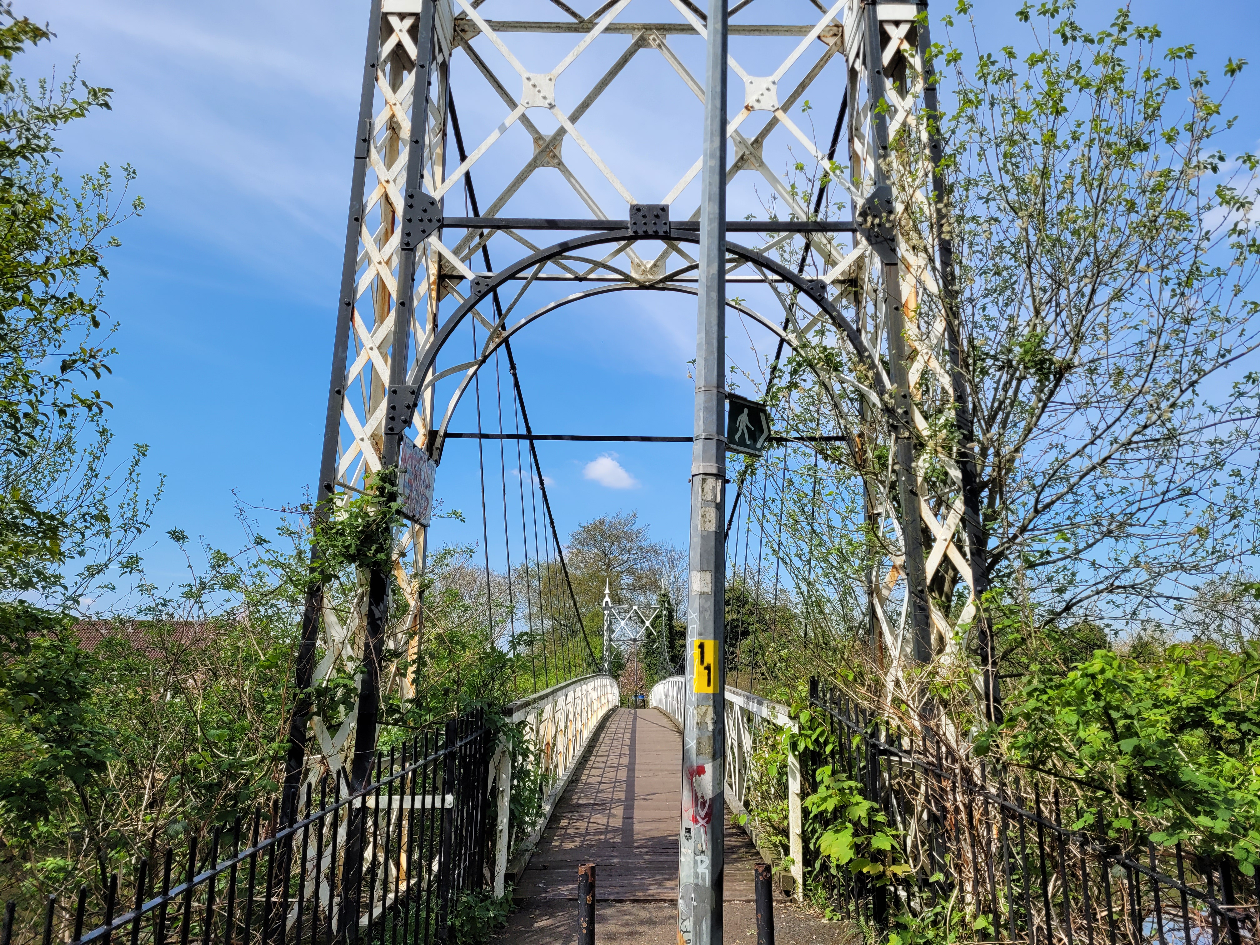
The Howley Bridge is a pedestrian footbridge which spans the River Mersey in Warrington, England. It connects Howley in Warrington to Victoria Park in Latchford. The bridge was constructed in 1912 by the London-based David Rowell & Co. It is a suspension bridge, constructed primarily of wrought iron with steel suspension cables and a timber-planked walkway. The bridge is similar in construction, appearance and properties to other bridges made by the company, such as Daly's Bridge. The Howley Bridge also shares the shakiness for which Daly's Bridge is known. The bridge received maintenance during the construction of the Warrington Flood defences. The bridge is a registered Grade II listed In the United Kingdom, a listed building is a structure of particular architectural or historic interest deserving of special protection. Such buildings are placed on one of the four statutory lists maintained by Historic England in England, H ... building. References {{coord, 53 ... [...More Info...] [...Related Items...] OR: [Wikipedia] [Google] [Baidu] |
Weir
A weir or low-head dam is a barrier across the width of a river that alters the flow characteristics of water and usually results in a change in the height of the water level. Weirs are also used to control the flow of water for outlets of lakes, ponds, and reservoirs. There are many weir designs, but commonly water flows freely over the top of the weir crest before cascading down to a lower level. There is no single definition as to what constitutes a weir. ''Weir'' can also refer to the skimmer found in most in-ground swimming pools, which controls the flow of water pulled into the filtering system. Etymology The word likely originated from Middle English ''were'', Old English ''wer'', a derivative of the root of the verb ''werian,'' meaning "to defend, dam". The German cognate is ''Wehr'', which means the same as English weir. Function Commonly, weirs are used to prevent flooding, measure water discharge, and help render rivers more Navigability, navigable by boat. In ... [...More Info...] [...Related Items...] OR: [Wikipedia] [Google] [Baidu] |
Victoria Of The United Kingdom
Victoria (Alexandrina Victoria; 24 May 1819 – 22 January 1901) was Queen of the United Kingdom of Great Britain and Ireland from 20 June 1837 until Death and state funeral of Queen Victoria, her death in January 1901. Her reign of 63 years and 216 days, which was List of monarchs in Britain by length of reign, longer than those of any of her predecessors, constituted the Victorian era. It was a period of industrial, political, scientific, and military change within the United Kingdom of Great Britain and Ireland, United Kingdom, and was marked by a great expansion of the British Empire. In 1876, the British parliament voted to grant her the additional title of Empress of India. Victoria was the daughter of Prince Edward, Duke of Kent and Strathearn (the fourth son of King George III), and Princess Victoria of Saxe-Coburg-Saalfeld. After the deaths of her father and grandfather in 1820, she was Kensington System, raised under close supervision by her mother and her Comptrol ... [...More Info...] [...Related Items...] OR: [Wikipedia] [Google] [Baidu] |
Victoria Park (Warrington)
Latchford is a suburb and electoral ward of Warrington, in the ceremonial county of Cheshire, England. It is around one mile south-east of Warrington town centre and has a total resident population of 7,856. Latchford is a predominantly residential area, Latchford lies between the River Mersey and the Manchester Ship Canal, and broadly consists of 19th-century terraced housing and some open space. The canal is crossed here by a swing bridge, a high-level road bridge and the now disused Latchford railway viaduct. Its name came from Anglo-Saxon ''Læccford'' meaning "boggy-stream ford". History Latchford was originally a township and chapelry in the ancient parish of Grappenhall, in Cheshire. It was also part of Bucklow Hundred, and was close to the border with Lancashire. In 1866 Latchford became a separate civil parish, on 30 September 1898 the parish was abolished and merged with Warrington. In 1891 the parish had a population of 6225. Between 1894 and 1974, part of Latchfor ... [...More Info...] [...Related Items...] OR: [Wikipedia] [Google] [Baidu] |
Stockton Heath
Stockton Heath is a civil parish and suburb of Warrington, in the Borough of Warrington, Cheshire, England. It is located to the north of the Bridgewater Canal and to the south of the Manchester Ship Canal, which divides Stockton Heath from Latchford and north Warrington. It has a total resident population of 6,396. Victoria Square is at the centre of Stockton Heath and is on the crossroads of the A49 and A56. Until the 1970s, the Victoria Hotel stood on this square but its location has been redeveloped. North of the square is the main shopping area which includes the Forge Shopping Centre, developed on the site of the old forge (Caldwell's). Stockton Heath is home to a number of modern bars and restaurants, as well as traditional public houses. The Red Lion Inn dates back to the early 19th century and the Mulberry Tree on Victoria Square, opened in its present building (replacing earlier premises dating from 1725) in March 190 Since 1988, much of the centre of Stockton Heath ... [...More Info...] [...Related Items...] OR: [Wikipedia] [Google] [Baidu] |
Wrought Iron
Wrought iron is an iron alloy with a very low carbon content (less than 0.05%) in contrast to that of cast iron (2.1% to 4.5%), or 0.25 for low carbon "mild" steel. Wrought iron is manufactured by heating and melting high carbon cast iron in an open charcoal or coke hearth or furnace in a process known as puddling. The high temperatures cause the excess carbon to oxidise, the iron being stirred or puddled during the process in order to achieve this. As the carbon content reduces, the melting point of the iron increases, ultimately to a level which is higher than can be achieved by the hearth, hence the wrought iron is never fully molten and many impurities remain. The primary advantage of wrought iron over cast iron is its malleability - where cast iron is too brittle to bend or shape without breaking, wrought iron is highly malleable, and much easier to bend. Wrought iron is a semi-fused mass of iron with fibrous slag inclusions (up to 2% by weight), which give it ... [...More Info...] [...Related Items...] OR: [Wikipedia] [Google] [Baidu] |
London And North Western Railway
The London and North Western Railway (LNWR, L&NWR) was a British railway company between 1846 and 1922. In the late 19th century, the LNWR was the largest joint stock company in the world. Dubbed the "Premier Line", the LNWR's main line connected four of the largest cities in England; London, Birmingham, Manchester and Liverpool, and, through cooperation with their Scottish partners, the Caledonian Railway also connected Scotland's largest cities of Glasgow and Edinburgh. Today this route is known as the West Coast Main Line. The LNWR's network also extended into Wales and Yorkshire. In 1923, it became a constituent of the London, Midland and Scottish (LMS) railway, and, in 1948, the London Midland Region of British Railways. History The company was formed on 16 July 1846 by the ( 9 & 10 Vict. c. cciv), which authorised the amalgamation of the Grand Junction Railway, London and Birmingham Railway and the Manchester and Birmingham Railway. This move was prompted, in ... [...More Info...] [...Related Items...] OR: [Wikipedia] [Google] [Baidu] |
Local Government Act 1972
The Local Government Act 1972 (c. 70) is an act of the Parliament of the United Kingdom that reformed local government in England and Wales on 1 April 1974. It was one of the most significant acts of Parliament to be passed by the Heath Government of 1970–74. The act took the total number of councils in England from 1,245 to 412 (excluding parish councils), and in Wales to 45. Its pattern of two-tier metropolitan and non-metropolitan county and district councils remains in use today in large parts of England, although the metropolitan county councils were abolished in 1986, and both county and district councils have been replaced with unitary authorities in many areas since the 1990s. In Wales, too, the Act established a similar pattern of counties and districts, but these have since been entirely replaced with a system of unitary authorities. Elections were held to the new authorities in 1973, and they acted as "shadow authorities" until the handover date. Elect ... [...More Info...] [...Related Items...] OR: [Wikipedia] [Google] [Baidu] |


