|
Karabudak, Hınıs
Karabudak is a neighbourhood in the municipality and district of Hınıs, Erzurum Province in Turkey. , Turkey Civil Administration Departments Inventory. Retrieved 12 July 2023. Its population is 36 (2022). It is 170 km from Erzurum city center and 18 km from Hınıs
Hınıs (; ) is a municipality and district of Erzurum Province, Turkey. Its area is 1,367 km2, and its population is 24,680 (2022). Historical monuments in the town include the castle and the Ulu Cami Mosque, said to be built in 1734 by A ... .
Population References |
Mahalle
is an Arabic word variously translated as district, quarter, ward, or neighborhood in many parts of the Arab world, the Balkans, Western Asia, the Indian subcontinent, and nearby nations. History Historically, mahallas were autonomous social institutions built around familial ties and Islamic rituals. Today it is popularly recognised also by non-Muslims as a neighbourhood in large cities and towns. Mahallas lie at the intersection of private family life and the public sphere. Important community-level management functions are performed through mahalle solidarity, such as religious ceremonies, life-cycle rituals, resource management and conflict resolution. It is an official administrative unit in many Middle Eastern countries. The word was brought to the Balkans through Ottoman Turkish ''mahalle'', but it originates in Arabic محلة (''mähallä''), from the root meaning "to settle", "to occupy". In September 2017, a Turkish-based association referred to the historical mahalle ... [...More Info...] [...Related Items...] OR: [Wikipedia] [Google] [Baidu] |
Hınıs
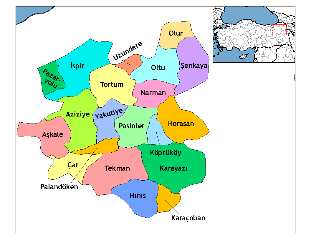
Hınıs (; ) is a municipality and district of Erzurum Province, Turkey. Its area is 1,367 km2, and its population is 24,680 (2022). Historical monuments in the town include the castle and the Ulu Cami Mosque, said to be built in 1734 by Alaeddin, the bey of Muş. The town is populated by Kurds. The district, which is 150 km away from the city of Muş, is very close to Hamurpert Lake, which has an important place in history. Hınıs district is surrounded by the Ak Dağ mountains from the north, Bingöl Mountains from the west and south, and Akdoğan mountains from the south to the east. Hınıs district is neighbors with Tekman and Karayazı districts to the north, Karaçoban district to the east, and Varto, Bulanık and Malazgirt districts of Muş to the south. In addition, the Varto city is only 40 km from Hınıs. Hınıs is a plain district and Hınıs Plain is one of the most fertile plains of the region. Therefore, agriculture and animal husbandry are the m ... [...More Info...] [...Related Items...] OR: [Wikipedia] [Google] [Baidu] |
Erzurum Province
Erzurum Province () is a province and metropolitan municipality in the Eastern Anatolia Region of Turkey. Its area is 25,006 km2, and its population is 749,754 (2022). The capital of the province is the city of Erzurum. It is the fourth largest province in all of Turkey. It is bordered by the provinces of Kars and Ağrı to the east, Muş and Bingöl to the south, Erzincan and Bayburt to the west, Rize and Artvin to the north and Ardahan to the northeast. The governor of the province is Mustafa Çiftçi, appointed in August 2023. The province has a Turkish majority. Geography The surface area of the province of Erzurum is the fourth biggest in Turkey. The majority of the province is elevated. Most plateaus are about above sea level, and the mountainous regions beyond the plateaus are and higher. Depression plains are located between the mountains and plateaus. The southern mountain ranges include the Palandöken Mountains (highest peak Büyük Ejder high) and t ... [...More Info...] [...Related Items...] OR: [Wikipedia] [Google] [Baidu] |
Erzurum
Erzurum (; ) is a List of cities in Turkey, city in eastern Anatolia, Turkey. It is the largest city and capital of Erzurum Province and is 1,900 meters (6,233 feet) above sea level. Erzurum had a population of 367,250 in 2010. It is the site of ancient Theodosiopolis. The city uses the double-headed eagle as its coat-of-arms, a motif that has been a common symbol throughout Anatolia since the Bronze Age. Erzurum has winter sports facilities, hosted the 2011 Winter Universiade, and the 2023 Winter Deaflympics (in March 2024). Name and etymology The city was originally known in Armenian language, Armenian as Karno K'aghak' (), meaning city of Karin, to distinguish it from the district of Karin (wikt:Կարին, Կարին). It is presumed its name was derived from a local tribe called the Karenitis. Darbinian, M. "Erzurum," Armenian Soviet Encyclopedia. Yerevan: Armenian Academy of Sciences, 1978, vol. 4, p. 93. An alternate theory contends that a local princely family, the Kams ... [...More Info...] [...Related Items...] OR: [Wikipedia] [Google] [Baidu] |
Turkish Statistical Institute
Turkish Statistical Institute (commonly known as TurkStat; or TÜİK) is the Turkish government agency commissioned with producing official statistics on Turkey, its population, resources, economy, society, and culture. It was founded in 1926 and headquartered in Ankara. Formerly named as the State Institute of Statistics (Devlet İstatistik Enstitüsü (DİE)), the institute was renamed as the Turkish Statistical Institute on November 18, 2005. See also * List of Turkish provinces by life expectancy References External linksOfficial website of the institute National statistical services Statistical Statistics (from German language, German: ', "description of a State (polity), state, a country") is the discipline that concerns the collection, organization, analysis, interpretation, and presentation of data. In applying statistics to a s ... Organizations established in 1926 Organizations based in Ankara {{Sci-org-stub ... [...More Info...] [...Related Items...] OR: [Wikipedia] [Google] [Baidu] |


