|
Galičica
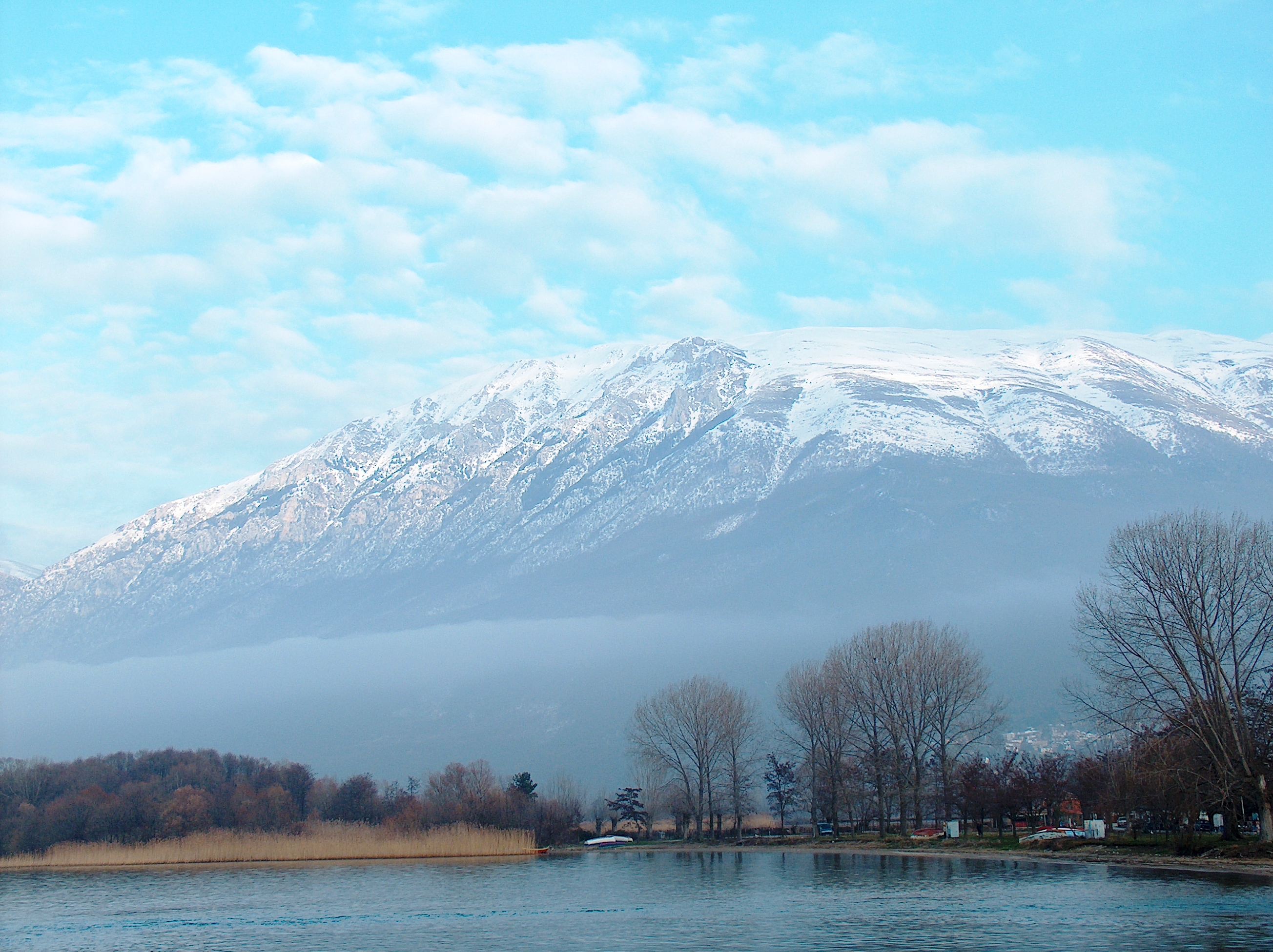
Galičica (, ) is a mountain situated across the border between North Macedonia and Albania. North Macedonia's side of the mountain is designated as a national park, positioned between the country's two largest lakes: Lake Ohrid and Lake Prespa, covering an area of . Rising to 2,265 metres above sea level, the mountain features varied terrain with steep slopes and significant elevational differences, creating diverse ecological zones dominated by forests and pastures. Since the 1950s, the landscape has undergone notable transformations, with forested areas increasing from 40% to 58% by 2007, while pasturelands decreased from 50% to 24% due to changing human activities. The mountain harbours exceptional biodiversity, with 180 woody plant taxa (56% of North Macedonia's dendroflora) and distinctive grassland communities that support numerous rare and endemic species. Human influence varies across the mountain, with Lake Ohrid shoreline settlements transitioning from agriculture to ... [...More Info...] [...Related Items...] OR: [Wikipedia] [Google] [Baidu] |
Lake Ohrid
Lake Ohrid is a lake which straddles the mountainous border between the southwestern part of North Macedonia and eastern Albania. It is one of Europe's deepest and oldest lakes, with a unique aquatic ecosystem of worldwide importance, with more than 200 endemic species. North Macedonia's side of Lake Ohrid was declared a World Heritage Site by UNESCO in 1979, with the site being extended to also include the cultural and historic area of Ohrid in 1980. In 2010, NASA named one of Lakes of Titan, Titan's lakes after it. In 2014, the Ohrid-Prespa Transboundary Reserve between Albania and North Macedonia was added to UNESCO's World Network of Biosphere Reserves. Albania's side of Lake Ohrid was also designated UNESCO world heritage status in 2019. North Macedonia's portion was designated as a protected Ramsar site in 2021, passing all nine criteria for proclamation.Ministry of Environment and Physical Planning (2021)Ramsar Information Sheet: Lake Ohrid. Ramsar Secretariat, Gland, Swit ... [...More Info...] [...Related Items...] OR: [Wikipedia] [Google] [Baidu] |
Lake Prespa
The Lake Prespa is located on the tripoint of North Macedonia, Albania and Greece. It is a system of two lakes separated by an isthmus: the Great Prespa Lake, divided between the three countries, and the Little Prespa Lake, mostly within Greece. They are the highest tectonic lakes in the Balkans, at an elevation of . The area contains three national parks: Galičica National Park in North Macedonia, Prespa National Park in Albania, and Prespa National Park in Greece. The largest town in the region is Resen in North Macedonia. In 2014, Ohrid-Prespa Transboundary Biosphere Reserve between Albania and North Macedonia was added to UNESCO's World Network of Biosphere Reserves. Geography The Great Prespa Lake (, ''Prespansko Ezero'', , , ''Megáli Préspa'') has the total surface of . The largest part of it, belongs to North Macedonia; to Albania; and to Greece. To the south, the Little Prespa Lake (Greek: Μικρή Πρέσπα, ''Mikri Prespa''; Albanian: ''Prespa e Vog ... [...More Info...] [...Related Items...] OR: [Wikipedia] [Google] [Baidu] |
North Macedonia
North Macedonia, officially the Republic of North Macedonia, is a landlocked country in Southeast Europe. It shares land borders with Greece to the south, Albania to the west, Bulgaria to the east, Kosovo to the northwest and Serbia to the north. It constitutes approximately the northern third of the larger geographical Macedonia (region), region of Macedonia. Skopje, the capital and largest city, is home to a quarter of the country's population of over 1.83 million. The majority of the residents are ethnic Macedonians (ethnic group), Macedonians, a South Slavs, South Slavic people. Albanians in North Macedonia, Albanians form a significant minority at around 25%, followed by Turks in North Macedonia, Turks, Romani people in North Macedonia, Roma, Serbs in North Macedonia, Serbs, Bosniaks in North Macedonia, Bosniaks, Aromanians in North Macedonia, Aromanians and a few other minorities. The region's history begins with the Paeonia (kingdom), kingdom of Paeonia. In the la ... [...More Info...] [...Related Items...] OR: [Wikipedia] [Google] [Baidu] |
Tree Line
The tree line is the edge of a habitat at which trees are capable of growing and beyond which they are not. It is found at high elevations and high latitudes. Beyond the tree line, trees cannot tolerate the environmental conditions (usually low temperatures, extreme snowpack, or associated lack of available moisture). The tree line is sometimes distinguished from a lower timberline, which is the line below which trees form a forest with a closed Canopy (biology), canopy. At the tree line, tree growth is often sparse, stunted, and deformed by wind and cold. This is sometimes known as (German for "crooked wood"). The tree line often appears well-defined, but it can be a more gradual transition. Trees grow shorter and often at lower densities as they approach the tree line, above which they are unable to grow at all. Given a certain latitude, the tree line is approximately 300 to 1000 meters below the permanent snow line and roughly parallel to it. Causes Due to their vertical s ... [...More Info...] [...Related Items...] OR: [Wikipedia] [Google] [Baidu] |
Pasture
Pasture (from the Latin ''pastus'', past participle of ''pascere'', "to feed") is land used for grazing. Types of pasture Pasture lands in the narrow sense are enclosed tracts of farmland, grazed by domesticated livestock, such as horses, cattle, sheep, or swine. The vegetation of tended pasture, forage, consists mainly of grasses, with an interspersion of legumes and other forbs (non-grass herbaceous plants). Pasture is typically grazed throughout the summer, in contrast to meadow which is ungrazed or used for grazing only after being mown to make hay for animal fodder. Pasture in a wider sense additionally includes rangelands, other unenclosed pastoral systems, and land types used by wild animals for grazing or browsing. Pasture lands in the narrow sense are distinguished from rangelands by being managed through more intensive agricultural practices of seeding, irrigation, and the use of fertilizers, while rangelands grow primarily native vegetation, managed with e ... [...More Info...] [...Related Items...] OR: [Wikipedia] [Google] [Baidu] |
Hydrology
Hydrology () is the scientific study of the movement, distribution, and management of water on Earth and other planets, including the water cycle, water resources, and drainage basin sustainability. A practitioner of hydrology is called a hydrologist. Hydrologists are scientists studying earth science, earth or environmental science, civil engineering, civil or environmental engineering, and physical geography. Using various analytical methods and scientific techniques, they collect and analyze data to help solve water related problems such as Environmentalism, environmental preservation, natural disasters, and Water resource management, water management. Hydrology subdivides into surface water hydrology, groundwater hydrology (hydrogeology), and marine hydrology. Domains of hydrology include hydrometeorology, surface-water hydrology, surface hydrology, hydrogeology, drainage basin, drainage-basin management, and water quality. Oceanography and meteorology are not included beca ... [...More Info...] [...Related Items...] OR: [Wikipedia] [Google] [Baidu] |
Flora
Flora (: floras or florae) is all the plant life present in a particular region or time, generally the naturally occurring (indigenous (ecology), indigenous) native plant, native plants. The corresponding term for animals is ''fauna'', and for fungi, it is ''funga''. Sometimes bacteria and fungi are also referred to as flora as in the terms ''gut flora'' or ''skin flora'' for purposes of specificity. Etymology The word "flora" comes from the Latin name of Flora (mythology), Flora, the goddess of plants, flowers, and fertility in Roman mythology. The technical term "flora" is then derived from a metonymy of this goddess at the end of the sixteenth century. It was first used in poetry to denote the natural vegetation of an area, but soon also assumed the meaning of a work cataloguing such vegetation. Moreover, "Flora" was used to refer to the flowers of an artificial garden in the seventeenth century. The distinction between vegetation (the general appearance of a community) and ... [...More Info...] [...Related Items...] OR: [Wikipedia] [Google] [Baidu] |
Orchard
An orchard is an intentional plantation of trees or shrubs that is maintained for food production. Orchards comprise fruit tree, fruit- or nut (fruit), nut-producing trees that are generally grown for commercial production. Orchards are also sometimes a feature of large gardens, where they serve an aesthetic as well as a productive purpose. A fruit garden is generally synonymous with an orchard, although it is set on a smaller, non-commercial scale and may emphasize berry shrubs in preference to fruit trees. Most temperate-zone orchards are laid out in a regular grid, with a grazed or mown lawn, grass or bare soil base that makes maintenance and fruit gathering easy. Most modern commercial orchards are planted for a single variety of fruit. While the importance of introducing biodiversity is recognized in forest plantations, introducing genetic diversity in orchard plantations by interspersing other trees might offer benefits. Genetic diversity in an orchard would provide resili ... [...More Info...] [...Related Items...] OR: [Wikipedia] [Google] [Baidu] |
Cirque
A (; from the Latin word ) is an amphitheatre-like valley formed by Glacier#Erosion, glacial erosion. Alternative names for this landform are corrie (from , meaning a pot or cauldron) and ; ). A cirque may also be a similarly shaped landform arising from fluvial erosion. The concave shape of a glacial cirque is open on the downhill side, while the cupped section is generally steep. Cliff-like slopes, down which ice and glaciated debris combine and converge, form the three or more higher sides. The floor of the cirque ends up bowl-shaped, as it is the complex convergence zone of combining ice flows from multiple directions and their accompanying rock burdens. Hence, it experiences somewhat greater erosion forces and is most often overdeepening, overdeepened below the level of the cirque's low-side outlet (stage) and its down-slope (backstage) valley. If the cirque is subject to seasonal melting, the floor of the cirque most often forms a tarn (lake), tarn (small lake) behind a d ... [...More Info...] [...Related Items...] OR: [Wikipedia] [Google] [Baidu] |
Pinus Peuce
''Pinus peuce'' (Macedonian pine or Balkan pine) (Serbo-Croatian and Macedonian: молика, molika; Bulgarian: бяла мура, byala mura) is a species of pine native to the mountains of North Macedonia, Bulgaria, Albania, Montenegro, Kosovo, the extreme southwest of Serbia, and the extreme north of Greece,Farjon, A. (2005). ''Pines. Drawings and descriptions of the genus Pinus'', ed.2. Brill, Leiden .Gymnosperm Databas''Pinus peuce''/ref> growing typically at (600-) 1,000-2,200 (-2,300) m altitude. It often reaches the alpine tree line in this area. The mature size is up to 35–40 m height, and 1.5 m trunk diameter. However, the height of the tree diminishes strongly near the upper tree line and may even obtain shrub sizes. It is a member of the white pine group, ''Pinus'' subgenus ''Strobus'', and like all members of that group, the leaves ('needles') are in fascicles (bundles) of five, with a deciduous sheath. They are 6–11 cm long. Its pine cones are mostly ... [...More Info...] [...Related Items...] OR: [Wikipedia] [Google] [Baidu] |
Forest
A forest is an ecosystem characterized by a dense ecological community, community of trees. Hundreds of definitions of forest are used throughout the world, incorporating factors such as tree density, tree height, land use, legal standing, and ecological function. The United Nations' Food and Agriculture Organization (FAO) defines a forest as, "Land spanning more than 0.5 hectares with trees higher than 5 meters and a Canopy (biology), canopy cover of more than 10 percent, or trees able to reach these thresholds ''in situ''. It does not include land that is predominantly under agricultural or urban use." Using this definition, ''Global Forest Resources Assessment (FRA), Global Forest Resources Assessment 2020'' found that forests covered , or approximately 31 percent of the world's land area in 2020. Forests are the largest Terrestrial ecosystem, terrestrial ecosystems of Earth by area, and are found around the globe. 45 percent of forest land is in the Tropical forest, trop ... [...More Info...] [...Related Items...] OR: [Wikipedia] [Google] [Baidu] |


