|
Galatea, New Zealand
Galatea () is a settlement in the Whakatāne District in the Bay of Plenty region of the North Island of New Zealand. The forested hills and mountains of the Ikawhenua Range and in particular Mount Tāwhiuau stand guard on the eastern flank of the ''Galatea Plains'' or Basin, an area surrounding the village. To the west, and over the Rangitaiki River stretch the of the Kaingaroa Forest. Demographics Galatea is in three surveyed SA1 statistical areas which covers a summed total of . The SA1 areas are a part of the Galatea statistical area. The SA1 area had a population of 444 at the 2018 New Zealand census, an increase of 6 people (1.37%) since the 2013 New Zealand census, 2013 census, and the 2006 New Zealand census, 2006 census. There were 165 households, comprising 222 males and 222 females, giving a sex ratio of 1.0 males per female. The median age was 33.9 years (compared with 37.4 years nationally), with 120 people (27.0%) aged under 15 years, 78 (17.6%) aged 15 to 29, ... [...More Info...] [...Related Items...] OR: [Wikipedia] [Google] [Baidu] |
Māori Language
Māori (; endonym: 'the Māori language', commonly shortened to ) is an Eastern Polynesian languages, Eastern Polynesian language and the language of the Māori people, the indigenous population of mainland New Zealand. The southernmost member of the Austronesian language family, it is related to Cook Islands Māori, Tuamotuan language, Tuamotuan, and Tahitian language, Tahitian. The Māori Language Act 1987 gave the language recognition as one of New Zealand's official languages. There are regional dialects of the Māori language. Prior to contact with Europeans, Māori lacked a written language or script. Written Māori now uses the Latin script, which was adopted and the spelling standardised by Northern Māori in collaboration with English Protestant clergy in the 19th century. In the second half of the 19th century, European children in rural areas spoke Māori with Māori children. It was common for prominent parents of these children, such as government officials, to us ... [...More Info...] [...Related Items...] OR: [Wikipedia] [Google] [Baidu] |
Pākehā
''Pākehā'' (or ''Pakeha''; ; ) is a Māori language, Māori-language word used in English, particularly in New Zealand. It generally means a non-Polynesians, Polynesian New Zealanders, New Zealander or more specifically a European New Zealanders, European New Zealander. It is not a legal term and has no definition under New Zealand law. ''Papa'a'' has a similar meaning in Cook Islands Māori. Etymology and history The etymology of is uncertain. The most likely sources are the Māori words or , which refer to an oral tale of a "mythical, human like being, with fair skin and hair who possessed canoes made of reeds which changed magically into sailing vessels". When Europeans first arrived they rowed to shore in longboats, facing backwards: In traditional Māori canoes or , paddlers face the direction of travel. This is supposed to have led to the belief by some, that the sailors were ''patupaiarehe'' (supernatural beings). There have been several dubious interpretati ... [...More Info...] [...Related Items...] OR: [Wikipedia] [Google] [Baidu] |
Polynesia
Polynesia ( , ) is a subregion of Oceania, made up of more than 1,000 islands scattered over the central and southern Pacific Ocean. The indigenous people who inhabit the islands of Polynesia are called Polynesians. They have many things in common, including Polynesian languages, linguistic relations, Polynesian culture, cultural practices, and Tradition, traditional beliefs. In centuries past, they had a strong shared tradition of sailing and Polynesian navigation, using stars to navigate at night. The term was first used in 1756 by the French writer Charles de Brosses, who originally applied it to all the list of islands in the Pacific Ocean, islands of the Pacific. In 1831, Jules Dumont d'Urville proposed a narrower definition during a lecture at the Société de Géographie of Paris. By tradition, the islands located in the South Seas, southern Pacific have also often been called the South Sea Islands, and their inhabitants have been called South Sea Islanders. The Hawai ... [...More Info...] [...Related Items...] OR: [Wikipedia] [Google] [Baidu] |
Frontage Road
A frontage road (also known as an access road, outer road, service road, feeder road, or parallel road) is a local road running parallel to a higher-speed, limited-access road. Where parallel high-speed roads are provided as part of a major highway, these are also known as local lanes. Sometimes a similar arrangement is used for city roads; for example, the collector portion of Commonwealth Avenue in Boston, Massachusetts, is known as a carriage road. A frontage road is often used to provide access to private driveways, shops, houses, industries or farms that would otherwise be cut off by a limited-access road. This can prevent the commercial disruption of an urban area that the freeway traverses or allow commercial development of bordering property. Advantages There are several advantages to using frontage roads. One advantage is to separate local traffic from through traffic. When frontage roads are lacking in an urban area, the highway is used as a local road, red ... [...More Info...] [...Related Items...] OR: [Wikipedia] [Google] [Baidu] |
Whakatāne
Whakatāne ( , ) is a town located in the Bay of Plenty Region, Bay of Plenty Region in the North Island of New Zealand, east of Tauranga and northeast of Rotorua. The town is situated at the mouth of the Whakatāne River. The Whakatāne District is the territorial authority that encompasses the town, covering an area to the south and west of the town, excluding the enclave of Kawerau, Kawerau District. Whakatāne has an urban population of , making it New Zealand's 33rd-largest urban area and the Bay of Plenty Region, Bay of Plenty's third-largest urban area, after Tauranga and Rotorua. Another people live in the rest of the Whakatāne District. Around 42% of the population identify as having Māori people, Māori ancestry, and 66% as having European/ ancestry, compared with 17% and 72% nationally (some people identify with multiple ethnicities). Whakatāne is part of the parliamentary electorate of East Coast, currently represented by Dana Kirkpatrick of the New Zealand N ... [...More Info...] [...Related Items...] OR: [Wikipedia] [Google] [Baidu] |
Te Urewera
Te Urewera is an area of mostly forested, sparsely populated rugged hill country in the North Island of New Zealand, located inland between the Bay of Plenty and Hawke Bay. Te Urewera is the ''rohe'' (historical home) of Tūhoe, a Māori iwi (tribe) known for its stance on Māori sovereignty. In 1954, a large area of Te Urewera was designated Te Urewera National Park by the New Zealand Government. In 2014 after a Waitangi Tribunal settlement with Tūhoe, the national park was disestablished and the former area was given environmental personhood. This area is now managed by Te Urewera Board, a body composed of both members who represent Tūhoe and the New Zealand Government. Outside of the protected area, Te Urewera includes land administered as Whirinaki Te Pua-a-Tāne Conservation Park, Onekawa Te Mawhai Regional Park, customary private land owned by Tūhoe, the settlements of Ruatoki North, Waimana, Tāneatua, and privately owned land. Geography The extent of T ... [...More Info...] [...Related Items...] OR: [Wikipedia] [Google] [Baidu] |
Whirinaki River (Hawke's Bay)
The Whirinaki River is a river of the Hawke's Bay and Bay of Plenty Regions of New Zealand's North Island. It flows generally north through the Whirinaki Te Pua-a-Tāne Conservation Park and Kaingaroa Forest to reach the Rangitaiki River north of Murupara. See also *List of rivers of New Zealand This is a list of all waterways named as rivers in New Zealand. A * Aan River * Acheron River (Canterbury) * Acheron River (Marlborough) * Ada River (New Zealand), Ada River * Adams River (New Zealand), Adams River * Ahaura River * Ahuriri R ... References Rivers of Hawke's Bay Rivers of the Bay of Plenty Region Te Urewera (protected area) {{HawkesBay-river-stub ... [...More Info...] [...Related Items...] OR: [Wikipedia] [Google] [Baidu] |
Religion Of Māori People
The Māori people, Māori people have a Polynesian mythology, Polynesian religion that, prior to the introduction of Christianity in New Zealand, Christianity to New Zealand was the main religious belief for Māori. By 1845, more than half of the Māori population attended church and Christianity remains the largest religion for Māori. Very few Māori still follow traditional Māori religion, although many elements of it are still observed. Several Māori religious movements have been born out of Christianity, such as the Ratana movement. Traditional Māori religion Traditional Māori religion, that is, the pre-European belief-system of the Māori people , Māori, differed little from that of their perceived homeland, Hawaiki, Hawaiki Nui, aka Raʻiātea or Raiatea, conceiving of everything – including natural elements and all living things – as connected by common descent through whakapapa or genealogy. Accordingly, Māori regarded all things as possessing a life force ( ... [...More Info...] [...Related Items...] OR: [Wikipedia] [Google] [Baidu] |
Christianity In New Zealand
Christianity in New Zealand dates to the arrival of missionary, missionaries from the Church Missionary Society who were welcomed onto the beach at Rangihoua Bay in December 1814. It soon became the predominant belief amongst the indigenous people, with over half of Māori people, Māori regularly attending church services within the first 30 years. Christianity remains New Zealand's largest religious group, but no one denomination is dominant and there is no official state church. According to the 2018 New Zealand census, 2018 census 38.17% of the population identified as Christians, Christian. The largest Christian groups are Anglican Church in New Zealand, Anglican, Catholic Church in New Zealand, Catholic and Presbyterian Church in New Zealand, Presbyterian. Christian organisations are the leading non-government providers of social services in New Zealand. History The first Christian church service, service conducted in New Zealand waters was probably to be carried out by F ... [...More Info...] [...Related Items...] OR: [Wikipedia] [Google] [Baidu] |
Pasifika New Zealanders
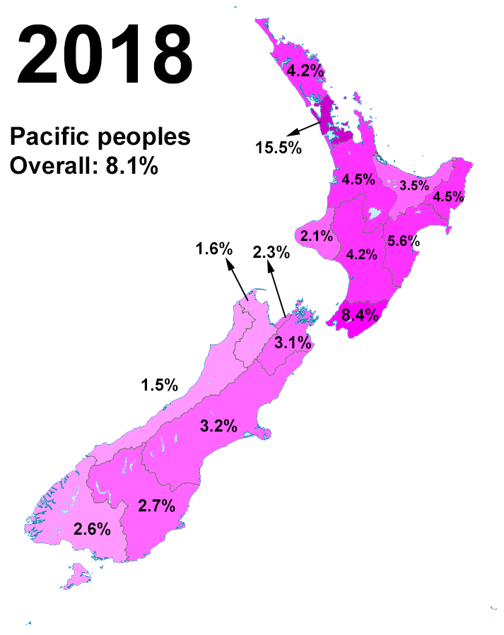
Pasifika New Zealanders (also called Pacific Peoples) are a pan-ethnic group of New Zealanders associated with, and descended from, the indigenous peoples of the Pacific Islands (also known as Pacific Islander#New Zealand, Pacific Islanders) outside New Zealand itself. They form the fourth-largest ethnic grouping in the country, after European New Zealanders, European descendants, indigenous Māori people, Māori, and Asian New Zealanders. Over 380,000 people identify as being of Pacific origin, representing 8% of the country's population, with the majority residing in Auckland. History Prior to the Second World War Pasifika in New Zealand numbered only a few hundred. Wide-scale Pasifika migration to New Zealand began in the 1950s and 1960s, typically from countries associated with the Commonwealth and the Realm of New Zealand, including Western Samoa (modern-day Samoa), the Cook Islands and Niue. In the 1970s, governments (both New Zealand Labour Party, Labour and New Zealand ... [...More Info...] [...Related Items...] OR: [Wikipedia] [Google] [Baidu] |
Murupara
Murupara is a town in the Whakatāne District and Bay of Plenty Region of New Zealand's North Island. The town is in an isolated part of the region between the Kaingaroa Forest and Te Urewera protected area, on the banks of the Rangitaiki River, 65 kilometres southeast of Rotorua. Indigenous Māori also make up over 90% of the population. It is on SH38 and is the terminus of the Murupara Railway Branch. The town's principal industries are all related to forestry. Murupara is in the ''rohe'' (tribal area) of the Ngāti Manawa iwi. The Māori language name means "to wipe off mud". History and culture History Murupara was previously a staging post on the road between Rotorua and Napier. In the early 1900s, the planting of exotic trees began on the surrounding scrubland. This area is now known as the Kaingaroa Forest, with 1,400 square kilometres of planted pines. As the main service centre for the many forestry workers and their families, Murupara grew to a population of ... [...More Info...] [...Related Items...] OR: [Wikipedia] [Google] [Baidu] |


