|
Frostastaðavatn
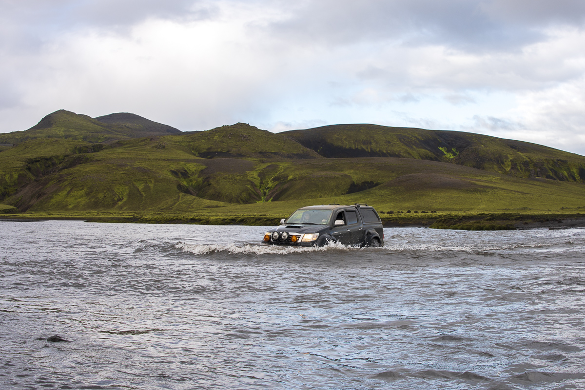
Frostastaðavatn (, Icelandic for ''lake of the frosty place'') is a lake in Iceland. It is situated in the Highlands of Iceland, not far from the famous mountains of Landmannalaugar and the volcano Hekla. Evidence of volcanism shows around this lake; for example in the famous mixed lava flows from the 1477 combined eruptions of the Torfajökull and Bárðarbunga volcanic systems reaching down to the shore (lava flows of rhyolitic as well as basaltic composition). Two highland roads run along its shore, ''Fjallabaksleið nyrðri'' (F 208) and ''Landmannaleið'' (F 225). See also * List of lakes in Iceland Iceland has over 20 lakes larger than 10 km2 (4 sq mi), and at least 40 others varying between 2.5 and 10 km2 (1 to 4 sq mi) in size. This list also includes a few smaller lakes and ponds that are considered notable (for example Tjörnin ... References External linksPhoto Lakes of Iceland {{Iceland-geo-stub ... [...More Info...] [...Related Items...] OR: [Wikipedia] [Google] [Baidu] |
List Of Lakes In Iceland
Iceland has over 20 lakes larger than 10 km2 (4 sq mi), and at least 40 others varying between 2.5 and 10 km2 (1 to 4 sq mi) in size. This list also includes a few smaller lakes and ponds that are considered notable (for example Tjörnin in Reykjavik). The figures for many of the smaller lakes are unreliable. Also, some larger lakes vary considerably in size between years or seasons or, for the reservoirs, according to the needs of power plants. Some power plant reservoirs may not be present despite being larger than listed lakes. Larger lakes (>10 km2) Smaller lakes (90 m (sensitive to climatic and geological change and was getting smaller - started recovering again in 2004) * Breiðárlón, 8 km2 * Reyðarvatn, 8.3 km2 * Hítarvatn, 7.6 km2, 24 m * Miklavatn (Fljót), 7.4 km2 * Miklavatn (Borgarsveit), 6.6 km2, 23 m * Árneslón, 6.5 km2, 116 * Sigríðarstaðavatn, 6.2 km2 * Laxárvatn, 6.0 km2 * Íshólsvatn, 5.2 km2, 39 m * Úlfljótsvatn, 60 m * Langa ... [...More Info...] [...Related Items...] OR: [Wikipedia] [Google] [Baidu] |
Highlands Of Iceland
The Highland (Icelandic language, Icelandic: ''Hálendið)'' or The Central Highland is an area that comprises much of the interior land of Iceland. The Highland is situated above and is mostly uninhabitable. The soil is primarily volcanic ash, and the terrain consists of basalt mountains and lava fields. Snow covers the Highland from October until the beginning of June. A few oasis-like areas, such as Herðubreiðarlindir and Thórsmörk, Þórsmörk, are also found in the Highland. The area has many notable natural features and hiking trails. Natural features in the Highland The Highland encompasses various geological features, including Landmannalaugar, Torfajökull, Eldgjá, Thórsmörk, Þórsmörk, Herðubreið, Askja, Hveradalir, Laki, Lakagígar, and the Fagrifoss waterfall. Sites in the Highland are difficult to access and may be accessible only during the summer months. Most sites require all-wheel drive or all-terrain vehicles for access due to the unpaved dirt ro ... [...More Info...] [...Related Items...] OR: [Wikipedia] [Google] [Baidu] |
Icelandic Language
Icelandic ( ; , ) is a North Germanic languages, North Germanic language from the Indo-European languages, Indo-European language family spoken by about 314,000 people, the vast majority of whom live in Iceland, where it is the national language. Since it is a West Scandinavian languages, West Scandinavian language, it is most closely related to Faroese language, Faroese, western Norwegian dialects, and the extinct language Norn language, Norn. It is not mutually intelligible with the continental Scandinavian languages (Danish language, Danish, Norwegian language, Norwegian, and Swedish language, Swedish) and is more distinct from the most widely spoken Germanic languages, English language, English and German language, German. The written forms of Icelandic and Faroese are very similar, but their spoken forms are not Mutual intelligibility, mutually intelligible. The language is more Linguistic conservatism, conservative than most other Germanic languages. While most of them hav ... [...More Info...] [...Related Items...] OR: [Wikipedia] [Google] [Baidu] |
Lake
A lake is often a naturally occurring, relatively large and fixed body of water on or near the Earth's surface. It is localized in a basin or interconnected basins surrounded by dry land. Lakes lie completely on land and are separate from the ocean, although they may be connected with the ocean by rivers. Lakes, as with other bodies of water, are part of the water cycle, the processes by which water moves around the Earth. Most lakes are fresh water and account for almost all the world's surface freshwater, but some are salt lakes with salinities even higher than that of seawater. Lakes vary significantly in surface area and volume of water. Lakes are typically larger and deeper than ponds, which are also water-filled basins on land, although there are no official definitions or scientific criteria distinguishing the two. Lakes are also distinct from lagoons, which are generally shallow tidal pools dammed by sandbars or other material at coastal regions of ocean ... [...More Info...] [...Related Items...] OR: [Wikipedia] [Google] [Baidu] |
Iceland
Iceland is a Nordic countries, Nordic island country between the Atlantic Ocean, North Atlantic and Arctic Oceans, on the Mid-Atlantic Ridge between North America and Europe. It is culturally and politically linked with Europe and is the region's westernmost and most list of countries and dependencies by population density, sparsely populated country. Its Capital city, capital and largest city is Reykjavík, which is home to about 36% of the country's roughly 380,000 residents (excluding nearby towns/suburbs, which are separate municipalities). The official language of the country is Icelandic language, Icelandic. Iceland is on a rift between Plate tectonics, tectonic plates, and its geologic activity includes geysers and frequent Types of volcanic eruptions, volcanic eruptions. The interior consists of a volcanic plateau with sand and lava fields, mountains and glaciers, and many Glacial stream, glacial rivers flow to the sea through the Upland and lowland, lowlands. Iceland i ... [...More Info...] [...Related Items...] OR: [Wikipedia] [Google] [Baidu] |
Landmannalaugar
Landmannalaugar () is a location in Iceland's Fjallabak Nature Reserve in the Highlands. It is on the edge of the Laugahraun lava field. This lava field was formed by an eruption in approximately 1477. It is largely known for its natural geothermal hot springs and surrounding landscape. Landmannalaugar is at the northern end of the Laugavegur hiking trail, and the Iceland Touring Association operates a mountain hut accommodating hikers. Activities Hiking Landmannalaugar is known for its hiking trails. Some routes include the hike through the Laugahraun Help:IPA/Icelandic, [ˈlœiːɣaˌr̥œiːn] lava field to Brennisteinsalda ("Sulphur Wave"), the one-hour hike up Bláhnjúkur ("Blue Peak"), and the four-hour hike to Ljótipollur Help:IPA/Icelandic, [ˈljouːtɪˌpʰɔtlʏr̥] crater lake ("Ugly Puddle"). Landmannalaugar can also be the starting point of several longer hiking trails, such as the Hellismannaleið Help:IPA/Icelandic, [ˈhɛtlɪsˌmanːa ... [...More Info...] [...Related Items...] OR: [Wikipedia] [Google] [Baidu] |
Volcano
A volcano is commonly defined as a vent or fissure in the crust of a planetary-mass object, such as Earth, that allows hot lava, volcanic ash, and gases to escape from a magma chamber below the surface. On Earth, volcanoes are most often found where tectonic plates are diverging or converging, and because most of Earth's plate boundaries are underwater, most volcanoes are found underwater. For example, a mid-ocean ridge, such as the Mid-Atlantic Ridge, has volcanoes caused by divergent tectonic plates whereas the Pacific Ring of Fire has volcanoes caused by convergent tectonic plates. Volcanoes resulting from divergent tectonic activity are usually non-explosive whereas those resulting from convergent tectonic activity cause violent eruptions."Mid-ocean ridge tectonics, volcanism and geomorphology." Geology 26, no. 455 (2001): 458. https://macdonald.faculty.geol.ucsb.edu/papers/Macdonald%20Mid-Ocean%20Ridge%20Tectonics.pdf Volcanoes can also form where there is str ... [...More Info...] [...Related Items...] OR: [Wikipedia] [Google] [Baidu] |
Hekla
Hekla (), or Hecla, is an active stratovolcano in the south of Iceland with a height of . Hekla is one of Iceland's most active volcanoes; over 20 eruptions have occurred in and around the volcano since the year 1210. During the Middle Ages, the Icelandic Norse called the volcano the "Gateway to Hell" and the idea spread over much of Europe. The volcano's frequent large and often initially explosive eruptions have covered much of Iceland with tephra, and these layers can be used to date eruptions of Iceland's other volcanoes. Approximately 10% of the tephra created in Iceland in the last thousand years has come from Hekla, amounting to . Cumulatively, the volcano has produced one of the largest volumes of lava of any in the world in the last millennium, around . Etymology In Icelandic language, Icelandic ''Hekla'' is the word for a short hooded cloak, which may relate to the frequent cloud cover on the summit. An early Latin source refers to the mountain as ''Mons chasuble, Cas ... [...More Info...] [...Related Items...] OR: [Wikipedia] [Google] [Baidu] |
Volcanism
Volcanism, vulcanism, volcanicity, or volcanic activity is the phenomenon where solids, liquids, gases, and their mixtures erupt to the surface of a solid-surface astronomical body such as a planet or a moon. It is caused by the presence of a heat source, usually internally generated, inside the body; the heat is generated by various processes, such as radioactive decay or tidal heating. This heat partially melts solid material in the body or turns material into gas. The mobilized material rises through the body's interior and may break through the solid surface. Causes For volcanism to occur, the temperature of the mantle must have risen to about half its melting point. At this point, the mantle's viscosity will have dropped to about 1021 Pascal-seconds. When large scale melting occurs, the viscosity rapidly falls to 103 Pascal-seconds or even less, increasing the heat transport rate a million-fold. The occurrence of volcanism is partially due to the fact that melted materi ... [...More Info...] [...Related Items...] OR: [Wikipedia] [Google] [Baidu] |
Torfajökull
Torfajökull ( Icelandic for "Torfi's glacier"; ) is a rhyolitic stratovolcano, with a large caldera (central volcano) capped by a glacier of the same name and associated with a complex of subglacial volcanoes. Torfajökull last erupted in 1477 and consists of the largest area of silicic extrusive rocks in Iceland. This is now known to be due to a VEI 5 eruption 55,000 years ago. Geography The volcano is located north of Mýrdalsjökull and south of Þórisvatn Lake, Iceland. To its south-west is the volcano and glacier of Tindfjallajökull and almost directly to its west is the volcano of Hekla. Adjacent to the southern edge of its glacier of Torfajökull it has a peak of but the south-eastern caldera margin also extends to the glacier of Kaldaklofsjökull which is on the western slopes of a peak called Háskerðingur that is high. Laufafell dome at is at the north-western edge of the Torfajökull volcanic system and almost halfway between Hekla and the glacier of Torfajö ... [...More Info...] [...Related Items...] OR: [Wikipedia] [Google] [Baidu] |
Bárðarbunga
Bárðarbunga (, alternative name Veiðivötn), is an active and productive stratovolcano located under Vatnajökull in Vatnajökull National Park which is Iceland's most extensive glacier. The second highest mountain in Iceland, above sea level, Bárðarbunga is also part of the Bárðarbunga-Veiðivötn volcanic system that is approximately long and wide. Bárðarbunga erupted in late August 2014, the eruption style effusive, which is common in Iceland, but had not been seen for a few years. Lava covered the surrounding landscape northwest of the Vatnajökull glacier. Description Bárðarbunga is a subglacial stratovolcano and central volcano under the ice cap of Vatnajökull glacier in the Vatnajökull National Park in Iceland. It is one of the six volcanic systems under Vatnajökull. The central volcano has a rim that rises to about above sea level, making it the second highest mountain in Iceland, being lower than Hvannadalshnjúkur. The caldera is about , u ... [...More Info...] [...Related Items...] OR: [Wikipedia] [Google] [Baidu] |


