|
Eask Tower
The Eask Tower is a solid stone tower on the top of Carhoo Hill, in County Kerry, Republic of Ireland, Ireland, overlooking Dingle harbour. Description Eask Tower was built in 1847 in order to guide the ships and boats into the mouth of the harbour. The wooden hand pointing from the Tower guides the boats to their destination. It is crowned with the 19th century's mariners beacon and a World War II look-out post. The harbour has a "blind" mouth, so the purpose of the tower is to advise the ships to retract their sails, lose speed and thus safely sail around the harbour mouth. The tower is of solid stone. The building of it on Carhoo (Ceathru) hill, above sea level, provided work during the Great Famine (Ireland), Great Famine, at the instigation of Reverend Charles Gayer, leader of the Protestants, in an attempt to win converts. The tower was originally high, but around the year 1900, the old hand was removed and an extra of stone was added to its height. A new hand was pla ... [...More Info...] [...Related Items...] OR: [Wikipedia] [Google] [Baidu] |
Dingle Peninsula
The Dingle Peninsula (; anglicised as Corkaguiny or Corcaguiny, the name of the corresponding barony) is the northernmost of the major peninsulas in County Kerry. It ends beyond the town of Dingle at Dunmore Head, the westernmost point of mainland Ireland. It is separated from the Iveragh Peninsula to the south by the Dingle Bay. Name The Dingle Peninsula is named after the town of Dingle. The peninsula is also commonly called ''Corca Dhuibhne'' ( Corcu Duibne) even when those referring to it are speaking in English. ''Corca Dhuibhne'', which means "seed or tribe of Duibhne" (a Goddess from Irish mythology and an Irish clan name), refers to the ''túath'' (people, nation) of ''Corco Dhuibhne'' who occupied the peninsula in the Middle Ages and who also held a number of territories in the south and east of County Kerry. Geography The peninsula exists because of the band of sandstone rock that forms the Slieve Mish mountain range at the neck of the peninsula, in the east, and ... [...More Info...] [...Related Items...] OR: [Wikipedia] [Google] [Baidu] |
Towers In The Republic Of Ireland
A tower is a tall Nonbuilding structure, structure, taller than it is wide, often by a significant factor. Towers are distinguished from guyed mast, masts by their lack of guy-wires and are therefore, along with tall buildings, self-supporting structures. Towers are specifically distinguished from buildings in that they are built not to be habitable but to serve other functions using the height of the tower. For example, the height of a clock tower improves the visibility of the clock, and the height of a tower in a fortified building such as a castle increases the visibility of the surroundings for defensive purposes. Towers may also be built for observation tower, observation, leisure, or telecommunication purposes. A tower can stand alone or be supported by adjacent buildings, or it may be a feature on top of a larger structure or building. Etymology Old English ''torr'' is from Latin ''turris'' via Old French ''tor''. The Latin term together with Greek language, Greek τύ ... [...More Info...] [...Related Items...] OR: [Wikipedia] [Google] [Baidu] |
Buildings And Structures In County Kerry
A building or edifice is an enclosed structure with a roof, walls and windows, usually standing permanently in one place, such as a house or factory. Buildings come in a variety of sizes, shapes, and functions, and have been adapted throughout history for numerous factors, from building materials available, to weather conditions, land prices, ground conditions, specific uses, prestige, and aesthetic reasons. To better understand the concept, see ''Nonbuilding structure'' for contrast. Buildings serve several societal needs – occupancy, primarily as shelter from weather, security, living space, privacy, to store belongings, and to comfortably live and work. A building as a shelter represents a physical separation of the human habitat (a place of comfort and safety) from the ''outside'' (a place that may be harsh and harmful at times). buildings have been objects or canvasses of much artistic expression. In recent years, interest in sustainable planning and building pract ... [...More Info...] [...Related Items...] OR: [Wikipedia] [Google] [Baidu] |
Mount Brandon
Mount Brandon or Brandon (), at , is one of the ten highest peaks in Ireland, being the 8th–highest peak in Ireland on the Arderin list, and the 9th–highest on the Vandeleur-Lynam list. Brandon is the highest Irish mountain outside the MacGillycuddy's Reeks range and has the greatest prominence of any Irish peak except Carrauntoohil, Ireland's highest mountain. Mount Brandon is at the centre of a long high ridge called the Brandon Group range of mountains in the Dingle Peninsula in County Kerry. The ridge contains seven other major peaks (i.e. above 2,000 ft in height); one is the similarly named Brandon Peak (840 metres). The positioning and dimensions of the Brandon Group ridge have made it the scene of several air accidents over the years. The mountain, and range, is named after Saint Brendan, and is the end of a Christian pilgrimage trail known as ''Cosán na Naomh''. It is also well regarded for hill walking with routes such as the 4–5-hour ''Faha Route'' (also call ... [...More Info...] [...Related Items...] OR: [Wikipedia] [Google] [Baidu] |
Carrauntoohil
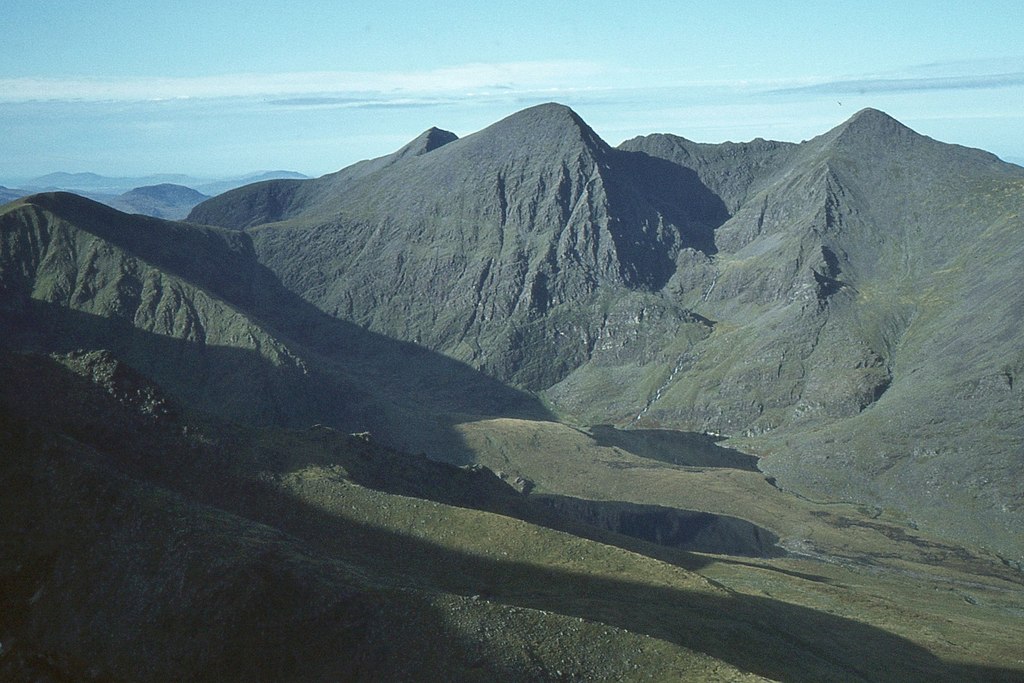
Carrauntoohil, Carrauntoohill or Carrantuohill ( ; , meaning "Tuathal's sickle") is the Lists of mountains in Ireland, highest mountain in Ireland at . It is on the Iveragh Peninsula in County Kerry, close to the centre of Ireland's highest mountain range, MacGillycuddy's Reeks. Carrauntoohil is composed mainly of sandstone, whose glaciation produced distinctive features on the mountain such as the Eagle's Nest cirque, corrie and some deep gullies and sharp arêtes in its east and northeastern faces that are popular with rock and winter climbers. As Ireland's highest mountain, Carrauntoohil is popular with mountain walkers, who most commonly ascend via the Devil's Ladder route; however, Carrauntoohil is also climbed as part of longer mountain walking routes in the MacGillycuddy's Reeks range, including the Coomloughra Horseshoe or the MacGillycuddy's Reeks Ridge Walk of the entire mountain range. Carrauntoohil, and most of the range is held in private ownership and is not par ... [...More Info...] [...Related Items...] OR: [Wikipedia] [Google] [Baidu] |
Iveragh Peninsula
The Iveragh Peninsula () is located in County Kerry in Republic of Ireland, Ireland. It is the largest peninsula in southwestern Ireland. A mountain range, the MacGillycuddy's Reeks, lies in the centre of the peninsula. Carrauntoohil, its highest mountain, is also the highest peak in Ireland. Geography Towns on the peninsula include Killorglin, Cahersiveen, Ballinskelligs, Portmagee, Knightstown, County Kerry, Knightstown, Waterville, County Kerry, Waterville, Caherdaniel, Sneem and Kenmare. The Ring of Kerry, a popular tourist trail, circles the coastlines as well as the Skellig Ring, beginning and ending at Killarney, just east of the peninsula. Valentia Island lies off the northwestern tip of the peninsula. It is connected with the peninsula by a bridge at Portmagee village, but it can also be reached by ferry crossing between Renard Point on the mainland and Knightstown, County Kerry, Knightstown on the island. The Skellig Islands lie about 12 kilometres (7.5 statu ... [...More Info...] [...Related Items...] OR: [Wikipedia] [Google] [Baidu] |
Ventry
Ventry (), officially ''Ceann Trá'', is a Gaeltacht village in County Kerry, Ireland, on the Dingle Peninsula, 7 kilometres west of Dingle. Due to its long sandy beach, Ventry is a tourist destination. History Six kilometres west of Ventry are the ruins of Dunbeg (''An Dún Beag''), an Iron Age promontory fort on the edge of a steep cliff. Near Dunbeg is Kilvickadownig, home to other archeological ruins, including examples of the beehive house and the grave of Caol or Cháil Mic Crimthainn, the last to die in the Battle of Ventry from the Fenian Cycle of Irish mythology. Also within Ventry parish is Rahinnane Castle, which was the residence of the Knight of Kerry. The Knight of Kerry lived there until Cromwellian conquest of Ireland. The castle was built on the site of an old ringfort. The ringfort was built up and a second added with walls of six metres (20 feet), giving the appearance that there may have been a moat, although there never was one. Rahinnane Castle ret ... [...More Info...] [...Related Items...] OR: [Wikipedia] [Google] [Baidu] |
Blasket Islands
The Blasket Islands () are an uninhabited group of islands off the west coast of the Dingle Peninsula in County Kerry, Ireland. The last island to hold a significant population, Great Blasket Island, was abandoned in 1954 due to population decline and is best known for a number of Irish language writers who vividly described their way of life and who kept alive old Irish folk tales of the land. Name The etymology of the name of the islands is uncertain, but it may be Old Norse in origin. It may have come from the word ''brasker'' meaning sharp reef of rock or dangerous place. The islands have also been called Ferriter's Islands. Topographer Charles Smith (topographer), Charles Smith referred to Great Blasket, the largest of the group of islands, as Inishmore. History The earliest known reference to the habitation of the islands is from the late 16th century. However, the Norman-Irish (Ferriter) family who rented the islands from the Earl of Desmond since maintained a castl ... [...More Info...] [...Related Items...] OR: [Wikipedia] [Google] [Baidu] |
Carhoo Hill
Carhoo Hill or Ballymacadoyle Hill () is a large hill south-west of Dingle in County Kerry, Ireland. Geography The high hill stands 4 km west of Dingle in an isolated position in the short peninsula dividing Dingle Harbour from the Atlantic Ocean. The top of the hill hosts the Eask Tower, a solid stone tower built in 1847. It offers a view on a long stretch of Dingle Peninsula and Iveragh Peninsula. Name The English meaning of ''Cnoc na Ceathrún '' is ''hill of the quarter''. Access to the summit The walk which leads up to the summit takes 1.6 km from the asphalted road. Due to the very interesting panorama it's advisable to choose a clear day for it. See also * List of Marilyns in Ireland * Dingle Bay Dingle Bay (''Bá an Daingin'' in Irish language, Irish) is a bay located in County Kerry, western Ireland. The outer parts of the Dingle Peninsula and Dingle Bay mark one of the westernmost points of mainland Ireland. The harbour town of Ding ... Re ... [...More Info...] [...Related Items...] OR: [Wikipedia] [Google] [Baidu] |
Great Famine (Ireland)
The Great Famine, also known as the Great Hunger ( ), the Famine and the Irish Potato Famine, was a period of mass starvation and disease in Ireland lasting from 1845 to 1852 that constituted a historical social crisis and had a major impact on Irish society and history as a whole. The most severely affected areas were in the western and southern parts of Ireland—where the Irish language was dominant—hence the period was contemporaneously known in Irish as , which literally translates to "the bad life" and loosely translates to "the hard times". The worst year of the famine was 1847, which became known as "Black '47".Éamon Ó Cuív – the impact and legacy of the Great Irish Famine The population of Ireland on the eve of the famine was about 8.5 million; by 1901, it was just 4.4 million. During the Great Hunger, roughly 1 million people died and more than 1 million more Irish diaspora, fled the country, causing the country's population to fall by 20–25% between 18 ... [...More Info...] [...Related Items...] OR: [Wikipedia] [Google] [Baidu] |


