|
Dras
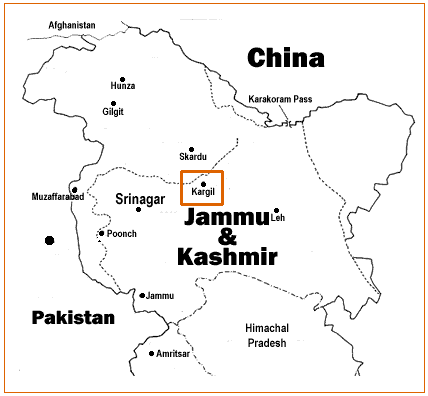
Dras (also spelt Drass, ISO transliteration: '), also known locally in Shina as Himababs, Hembabs, or Humas, is a town and hill station in Kargil district of the union territory of Ladakh in India. It is on the NH 1 between Zoji La pass and Kargil town. A tourist hub for its high-altitude trekking routes and tourist sites, it is often called "The Gateway to Ladakh". The government's official spelling of the town's name is "Drass". Etymology Traditionally, Dras is known as ''Hem-babs'', which means "snow land"; the word "Hem" means snow. The average temperature of Dras in winter is -20 degrees Celsius. Geography Dras is often called "The Gateway to Ladakh". It is at a height of Dras lies in the centre of the valley of the same name (Dras valley). Dras is 140 km from Srinagar and 63 km from Sonmarg. Kargil town is 58 km from Dras on the national highway NH 1 from Srinagar to Leh. History In the princely state of Jammu and Kashmir (1846–1947), Dras ... [...More Info...] [...Related Items...] OR: [Wikipedia] [Google] [Baidu] |
Kargil District
Kargil district is a district in Indian-administered Ladakh in the Kashmir#Dispute, disputed Kashmir-region,The application of the term "administered" to the various regions of Kashmir and a mention of the Kashmir dispute is supported by the WP:TERTIARY, tertiary sources (a) through (e), reflecting WP:DUE, due weight in the coverage. Although "controlled" and "held" are also applied neutrally to the names of the disputants or to the regions administered by them, as evidenced in sources (h) through (i) below, "held" is also considered politicised usage, as is the term "occupied," (see (j) below). (a) (subscription required) Quote: "Kashmir, region of the northwestern Indian subcontinent ... has been the subject of dispute between India and Pakistan since the partition of the Indian subcontinent in 1947. The northern and western portions are administered by Pakistan and comprise three areas: Azad Kashmir, Gilgit, and Baltistan, the last two being part of a territory called the ... [...More Info...] [...Related Items...] OR: [Wikipedia] [Google] [Baidu] |
Ladakh
Ladakh () is a region administered by India as a union territory and constitutes an eastern portion of the larger Kashmir region that has been the subject of a Kashmir#Kashmir dispute, dispute between India and Pakistan since 1947 and India and China since 1959.The application of the term "administered" to the various regions of Kashmir and a mention of the Kashmir dispute is supported by the WP:TERTIARY, tertiary sources (a) through (e), reflecting WP:DUE, due weight in the coverage. Although "controlled" and "held" are also applied neutrally to the names of the disputants or to the regions administered by them, as evidenced in sources (h) through (i) below, "held" is also considered politicised usage, as is the term "occupied", (see (j) below). (a) (subscription required) Quote: "Kashmir, region of the northwestern Indian subcontinent ... has been the subject of dispute between India and Pakistan since the partition of the Indian subcontinent in 1947. The northern and wester ... [...More Info...] [...Related Items...] OR: [Wikipedia] [Google] [Baidu] |
Shina Language
Shina ( , ) is a Dardic languages, Dardic language of Indo-Aryan languages, Indo-Aryan language family spoken by the Shina people. In Pakistan, Shina is the major language in Gilgit-Baltistan spoken by an estimated 1,146,000 people living mainly in Gilgit-Baltistan and Kohistan District, Pakistan, Kohistan. A small community of Shina speakers is also found in India, in the Gurez valley of Jammu and Kashmir (union territory), Jammu and Kashmir and in Dras valley of Ladakh. Shina languages, Outliers of Shina language such as Brokskat are found in Ladakh, Kundal Shahi language, Kundal Shahi in Azad Kashmir, Palula language, Palula and Sawi language (Dardic), Sawi in Chitral, Ushoji language, Ushojo in the Swat District, Swat Valley and Kalkoti language, Kalkoti in Dir, Pakistan, Dir. Until recently, there was no writing system for the language. A number of schemes have been proposed, but presently, there is no single writing system used by speakers of Shina. Shina is mostly a spoke ... [...More Info...] [...Related Items...] OR: [Wikipedia] [Google] [Baidu] |
Kargil War Memorial, Operation Vijay
Kargil or Kargyil is a City in Indian-administered Ladakh in the disputed Kashmir region. The application of the term "administered" to the various regions of Kashmir and a mention of the Kashmir dispute is supported by the tertiary sources (a) through (e), reflecting due weight in the coverage. Although "controlled" and "held" are also applied neutrally to the names of the disputants or to the regions administered by them, as evidenced in sources (h) through (i) below, "held" is also considered politicized usage, as is the term "occupied," (see (j) below). (a) (subscription required) Quote: "Kashmir, region of the northwestern Indian subcontinent ... has been the subject of dispute between India and Pakistan since the partition of the Indian subcontinent in 1947. The northern and western portions are administered by Pakistan and comprise three areas: Azad Kashmir, Gilgit, and Baltistan, the last two being part of a territory called the Northern Areas. Administered by Indi ... [...More Info...] [...Related Items...] OR: [Wikipedia] [Google] [Baidu] |
National Highway 1 (India)
National Highway 1 (NH 1) in India runs between the States and territories of India, union territories of Jammu and Kashmir (union territory), Jammu & Kashmir and Ladakh. It comprises parts of old National Highway 1A (India, old numbering), NH1A and National Highway 1D , NH1D. The number 1 indicates, under the new numbering system, that it is the northernmost East–west highway in India. History A track between Srinagar in the Kashmir Valley and Leh in Ladakh had existed since medieval times, and it was a prime trade route for many centuries. It passed through the Zoji La pass——over the Great Himalayan range, which is snowbound for half the year. After the Independence of India, the Government of Jammu and Kashmir (state), Jammu and Kashmir started building a motorable road along the route in 1954. The construction was suspended in 1958 after discovery of corruption among the contractors and engineers, and an enquiry was initiated. In 1960, the Government of India cr ... [...More Info...] [...Related Items...] OR: [Wikipedia] [Google] [Baidu] |
List Of Hill Stations In India
Hill stations are high-altitude towns for recreation, enjoyment and used as a place of refuge to escape the blistering heat in India during summertime. As India is a vast country with limited amounts of the coastal area most of its towns and districts face Continental climate, continental type of climate with summer being very hot so hill stations (as situated on high altitude due to which it faces low temperature) becomes a spot to escape such hot and humid conditions. Indian subcontinent, The Indian subcontinent has seven principal mountain ranges and the largest of all is the Himalayas that lies in the northern part of India. The famous peaks and ranges include the Kangchenjunga range in the Eastern Himalayas which frames the hill stations of Darjeeling and Gangtok as well as the Nanda Devi in Uttarakhand. The Sivalik Hills, Shivalik range that also lies within the same region also has some famous hill stations that include Shimla, Manali, Himachal Pradesh, Manali, Kasauli, Mu ... [...More Info...] [...Related Items...] OR: [Wikipedia] [Google] [Baidu] |
Operation Bison (Jammu & Kashmir 1948)
Operation Bison is the codename of the assault and capture of Zoji La, Dras and Kargil district in Ladakh by the Indian Army during the Indo-Pakistani War of 1947-1948. Zoji La had been seized by Pakistani raiders in 1948 in their campaign to capture Ladakh. The pass was recaptured by Indian forces on 1 November in a daring assault, which achieved success primarily due to the surprise use of armour, then the highest altitude at which armour had operated in combat in the world. Initially, an unsuccessful attack was launched by the 77th Parachute Brigade (Brig Atal) to capture Zoji La. Operation Duck, the earlier name for this assault, was renamed as Operation Bison by Lt Gen Cariappa, the Western Army commander. M5 Stuart light tanks of the 7th Cavalry regiment were moved in dismantled condition through Srinagar and winched across bridges while two field companies of the Madras Sappers converted the mule track from Baltal up the Zoji La to Gumri into a jeep track. The surp ... [...More Info...] [...Related Items...] OR: [Wikipedia] [Google] [Baidu] |
Zoji La
Zoji La (sometimes Zojila Pass) is a high mountain pass in the Himalayas. It is located in the Ganderbal district of Jammu and Kashmir and the Kargil district of Ladakh, both union territories of India. This pass connects the Kashmir Valley to its west with the Dras and Suru valleys to its northeast and the Indus valley further east. National Highway #1 between Srinagar and Leh in the western section of the Himalayan mountain range, traverses the pass. As of late 2022, an all-weather Zoji-la Tunnel is under construction to mitigate seasonal road blockages due to heavy snowfall. Etymology According to some sources, ''Zoji La'' means the "mountain pass of blizzards".Zojila Battle of 1948—When Indians Surp ... [...More Info...] [...Related Items...] OR: [Wikipedia] [Google] [Baidu] |
Gilgit Scouts
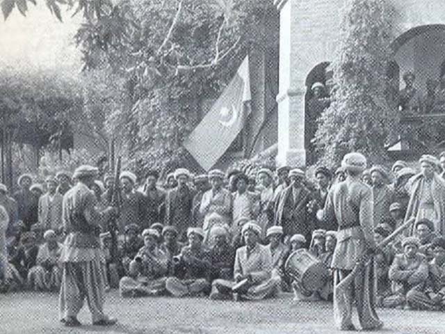
The Gilgit Scouts was a paramilitary force within the Gilgit-Baltistan region in northern Pakistan. They were raised by the British Raj in 1913, to assist the Gilgit-based British Political Agent in managing Gilgit Agency which formed the northern frontier of British India. The force had a strength of almost 600 composed of local men recruited by British commanders. Not only Gilgit Tehsil, which had been leased to the British Raj for 60 years starting in 1935 by Hari Singh the ruler of Jammu & Kashmir but the whole of Gilgit Agency which was under British control was ceded to Hari Singh on 1st July 1947. Following Jammu & Kashmir's accession to India on 26th October 1947, the Gilgit Scouts under the command of Major William Brown, staged a rebellion and overthrew the Governor of Gilgit. In a matter of days the 6th Battalion of Jammu & Kashmir in Bunji was routed by a Gilgit Scouts force under command Captain Mathieson the deputy commandant and Assistant Political Agent operati ... [...More Info...] [...Related Items...] OR: [Wikipedia] [Google] [Baidu] |
Jammu And Kashmir (princely State)
Jammu and Kashmir, also known as Kashmir and Jammu, was a princely state in a subsidiary alliance with the Company rule in India, British East India Company from 1846 to 1858 and under the ''Suzerainty#British_paramountcy, paramountcy'' (or tutelage) of the The Crown, British Crown, from 1858 until the Partition of India in 1947, when it became a Kashmir#Kashmir_dispute, disputed territory, now administered by three countries: China, India, and Pakistan. Quote: "Kashmir, region of the northwestern Indian subcontinent. It is bounded by the Uygur Autonomous Region of Xinjiang to the northeast and the Tibet Autonomous Region to the east (both parts of China), by the Indian states of Himachal Pradesh and Punjab to the south, by Pakistan to the west, and by Afghanistan to the northwest. The northern and western portions are administered by Pakistan and comprise three areas: Azad Kashmir, Gilgit, and Baltistan, ... The southern and southeastern portions constitute the Indian state of ... [...More Info...] [...Related Items...] OR: [Wikipedia] [Google] [Baidu] |


